119:
112:
26:
375:
349:
The mountain is however a very important site for unpowered aerial sports because it has the only suitable terrain for the demanding sport of model gliders with an east–west disposition for about 50 km around and was also previously used by kite flyers and paragliders.
371:) is situated on the western slope at a height of 835 m. There are plans to move the hut to a "place more compatible with nature preservation", and also to reach an agreement with the glider flyers who are not allowed to use the mountain any more.
515:
68:
398:
288:
327:
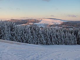
The northern slope falls steeply away and is covered with mixed, deciduous forest. The arc from southwest to east is open; mainly covered by grasses,
264:("Long Rhön") which is in turn part of the High Rhön. 2 km south is the village of Oberweißenbrunn, 4 km to the southeast is the town of
346:
The
Himmeldunkberg lies in a nature reserve of the same name; for that reason mountain bikes may only be used on tracks with mountain bike signs.
550:
476:
545:
530:
111:
481:
506:
489:
535:
61:
461:
540:
265:
171:
275:
The Rhine-Weser watershed runs over the summit of the
Himmeldunkberg and neighbouring hill of
367:
362:
8:
394:
296:
292:
184:
402:
31:
422:
438:
410:
510:
493:
390:("witches' beeches") nature monument, which is a favourite photographic subject.
336:
151:
25:
524:
503:
406:
83:
70:
276:
374:
291:(RHW). Border stones erected in 1872 show where the old border between the
205:
457:
487:
Conflict between sport and environmental protection e.g at
Himmeldunkberg
486:
426:
414:
358:
418:
328:
241:
52:
340:
482:
332:
308:
269:
393:
From the plateau there is a superb view over
Bischofsheim to the
280:
235:
177:
139:
131:
248:
158:
312:
189:
135:
45:
252:) in Germany. It straddles the Bavarian-Hessian state border.
284:
316:
193:
497:
260:
504:
Himmeldunkberg in hanggliding guide for model flyers
522:
386:About 50 m south, below the summit, is the
255:
425:can be seen. From the northeastern flank the
451:
307:The Himmeldunkberg consists mainly of the
405:, the Black Mountains, the Schachen, the
373:
287:as well as the long-distance trail, the
523:
462:Federal Agency for Nature Conservation
118:
13:
413:, the Reesberg, the valley of the
14:
562:
516:Walking around the Himmeldunkberg
470:
477:More information at rhoenline.de
117:
110:
34:north towards the Himmeldunkberg
24:
551:Mountains and hills of the Rhön
279:and forms the boundary between
421:. In very good conditions the
322:
1:
444:
256:Location and surrounding area
382:, view towards the Kreuzberg
7:
546:Mountains under 1000 metres
531:Extinct volcanoes of Europe
432:
268:and 3 km northwest is
240:888 m above
51:888 m above
10:
567:
302:
245:m high, in the High Rhön (
204:
199:
183:
170:
165:
150:
104:
99:
60:
44:
39:
23:
18:
266:Bischofsheim an der Rhön
383:
377:
363:German Alpine Society
536:Mountains of Bavaria
84:50.42278°N 9.95972°E
357:, belonging to the
80: /
541:Mountains of Hesse
509:2007-09-27 at the
492:2005-04-29 at the
384:
353:A refuge hut, the
297:Kingdom of Prussia
293:Kingdom of Bavaria
40:Highest point
429:is also visible.
423:Fichtel Mountains
224:
223:
89:50.42278; 9.95972
558:
464:
455:
355:Würzburger Hütte
244:
208:
154:
121:
120:
114:
95:
94:
92:
91:
90:
85:
81:
78:
77:
76:
73:
55:
28:
16:
15:
566:
565:
561:
560:
559:
557:
556:
555:
521:
520:
511:Wayback Machine
494:Wayback Machine
473:
468:
467:
456:
452:
447:
435:
337:silver thistles
325:
305:
258:
239:
218:Schwedenschanze
206:
152:
146:
145:
144:
143:
142:
129:
128:
127:
126:
122:
88:
86:
82:
79:
74:
71:
69:
67:
66:
56:(2,913 ft)
50:
35:
12:
11:
5:
564:
554:
553:
548:
543:
538:
533:
519:
518:
513:
501:
484:
479:
472:
471:External links
469:
466:
465:
449:
448:
446:
443:
442:
441:
439:Rhön Mountains
434:
431:
417:and the upper
361:branch of the
324:
321:
304:
301:
289:Rhön-Höhen-Weg
257:
254:
242:sea level (NN)
234:is an extinct
228:Himmeldunkberg
222:
221:
210:
202:
201:
197:
196:
187:
181:
180:
174:
168:
167:
163:
162:
156:
148:
147:
130:
125:Himmeldunkberg
124:
123:
116:
115:
109:
108:
107:
106:
105:
102:
101:
97:
96:
64:
58:
57:
53:sea level (NN)
48:
42:
41:
37:
36:
29:
21:
20:
19:Himmeldunkberg
9:
6:
4:
3:
2:
563:
552:
549:
547:
544:
542:
539:
537:
534:
532:
529:
528:
526:
517:
514:
512:
508:
505:
502:
499:
495:
491:
488:
485:
483:
480:
478:
475:
474:
463:
459:
454:
450:
440:
437:
436:
430:
428:
424:
420:
416:
412:
408:
404:
400:
396:
391:
389:
381:
376:
372:
370:
369:
364:
360:
356:
351:
347:
344:
342:
338:
334:
330:
320:
318:
314:
310:
300:
298:
294:
290:
286:
282:
278:
273:
271:
267:
263:
253:
251:
250:
243:
237:
233:
229:
219:
215:
211:
209:
207:Easiest route
203:
198:
195:
191:
188:
186:
182:
179:
175:
173:
172:Mountain type
169:
164:
160:
157:
155:
149:
141:
137:
133:
113:
103:
98:
93:
65:
63:
59:
54:
49:
47:
43:
38:
33:
27:
22:
17:
458:Map services
453:
392:
387:
385:
379:
366:
354:
352:
348:
345:
326:
306:
274:
261:
259:
246:
231:
227:
225:
217:
214:Schwedenwall
213:
185:Type of rock
153:Parent range
427:Heidelstein
411:Dammersfeld
401:ruins, the
388:Hexenbuchen
380:Hexenbuchen
341:bellflowers
323:Description
262:Langen Rhön
161:(Hohe Rhön)
87: /
62:Coordinates
525:Categories
445:References
329:blackthorn
277:Hohe Hölle
232:Himmeldunk
72:50°25′22″N
30:View from
407:Eierhauck
399:Osterburg
395:Kreuzberg
333:rose hips
220:car parks
212:from the
100:Geography
75:9°57′35″E
46:Elevation
507:Archived
490:Archived
433:See also
403:Arnsberg
359:Würzburg
309:volcanic
295:and the
270:Gersfeld
200:Climbing
176:Extinct
32:Arnsberg
460:of the
303:Geology
281:Bavaria
236:volcano
178:volcano
166:Geology
140:Germany
132:Bavaria
409:, the
397:, the
313:basalt
311:rocks
190:Basalt
136:Hessen
415:Brend
299:ran.
285:Hesse
247:Hohe
419:Sinn
378:The
339:and
317:tuff
315:and
283:and
249:Rhön
226:The
194:tuff
192:and
159:Rhön
498:pdf
368:DAV
230:or
216:or
527::
343:.
335:,
331:,
319:.
272:.
238:,
138:,
500:)
496:(
365:(
134:/
Text is available under the Creative Commons Attribution-ShareAlike License. Additional terms may apply.

