20:
264:
287:
302:
443:
The
Ptolemy map shows three rivers which are joined together to form as their source a single river which does not actually exist. It has however been suggested that this might be an indication of the existence of an ancient transpeninsular route that linked Perak and Pahang, a short cut between the
434:
as they may not be based on astronomical observation, and therefore cannot be reliably used for identification. Ptolemy's work was also copied and translated over many hundreds of years, with the oldest surviving version copied over a thousand years after it was written, and errors may have been
430:, including towns and rivers. Different identities however have been suggested by different scholars for these names. Although coordinates are given for many of these places, they are not considered reliable for places so far away from the
319:, which gives some geographical locations on the peninsula. The earliest surviving maps of Ptolemy, however, came from the end of the 13th century. Note that Ptolemy, like many early geographers, believed the
734:– the name appears to refer to a "Malay Point", perhaps the south east corner of the Malay Peninsula. Some have identified it as Tanjung Penyabong or Tanjung Tenggaroh in Johor to Tanjung Gelang in Pahang.
650:– at least 10 different sets of coordinates have been given in different texts for this site, it is therefore difficult to pinpoint and there is no agreement in its identification.
942:
Udai
Prakash Arora, “Greek Geographers on the Indian Ocean and Southeast Asia”, in Chattopadhyaya, D. P. and Project of History of Indian Science, Philosophy, and Culture (eds.),
235:, the term is now generally accepted to mean the Malay Peninsula. The Malay Peninsula is thought to have been a producer of gold in ancient times, and gold mines in
1312:
997:
453:
river, meaning "River of Gold", proposed to be various rivers on the west coast, from the Trang River (in southern
Thailand) or Lungu River, to the
116:
The earliest references to a fabulous land of gold that could be interpreted as places in
Southeast Asia may be found in Indian literature. In the
537:
19:
227:
includes information added by later geographers, and the first specific mention of the Golden
Chersonese may be in the work of
1301:
327:
were aware that the idea of the Indian Ocean as a closed basin was a mistake by the 8th century, for example in the work of
278:. The Indian Ocean is depicted as a closed basin. The Golden Chersonese is the peninsula to the far east, just prior to the
1379:
333:
231:. Chersonese means peninsula in Greek, and although a few early scholars had attempted to link the Golden Chersonese with
1335:
268:
592:
in
Thailand. It is thought to be an Indian name, but it has also been proposed to be a hybrid of Malay and Sanskrit –
1194:
1119:
1073:
1394:
1027:
91:
802:
323:
to be a closed sea, and maps based on
Ptolemy's work show the Golden Chersonese located within a closed basin.
807:
1399:
545:
1346:
639:
354:
236:
1090:
324:
1384:
1351:
The Golden
Khersonese: Studies in the Historical Geography of the Malay Peninsula before A.D. 1500
1028:
Were the
Hawaiian Islands visited by the Spaniards before their Discovery by Captain Cook in 1778?
812:
424:
The names of various geographical features and settlements of the Golden
Chersonese are given in
188:
150:, but specific references to places in Southeast Asia did not appear until after the rise of the
223:, contains the best-known and perhaps the earliest reference to the Golden Chersonese. However,
682:– thought to be located on the north east coast of the Malay Peninsula, and suggested to be in
426:
63:
1109:
1063:
1184:
412:. An expedition was sent to find the purported islands in this location under the command of
1303:
Researches on Ptolemy's geography of Eastern Asia (further India and Indo-Malay archipelago)
248:
1354:
785:
505:
159:
244:
8:
1017:
tr. and annotated by W.F. Sinclair, London, Hakluyt Society, Series 2, Vol.9, 1902, p.10.
817:
346:
228:
211:
147:
104:
95:
28:
799:", another gold-related name used for Southeast Asia by Chinese emigrants in later times
1327:
516:
is another suggestion. Takola was known to the Indians in ancient times; a place named
367:
294:
247:. Although gold is no longer a major product of modern-day Malaysia, it is still being
1358:
1190:
1115:
1069:
752:
671:
513:
397:
389:
328:
305:
194:
24:
1389:
879:
796:
711:
541:
413:
99:
47:
1306:. Asiatic Society Monographs. Vol. 1. Royal Asiatic Society. pp. 77–111.
822:
350:
216:
183:
87:
35:
884:
1313:"The Identifications of Some of Ptolemy's Place Names in the Golden Khersonese"
1059:
747:, although alternative proposals ranging from the Bay of Patani to the lake of
707:
573:
509:
163:
75:
1373:
1362:
1186:
Hubungan Politik dan Sosiobudaya China-Dunia Melayu Hingga Kurun ke-15 Masihi
932:
748:
715:
702:- placed on the north east coast of the Malay Peninsula, suggestions include
687:
605:
569:
528:
431:
252:
232:
220:
780:
744:
627:
486:
458:
379:
320:
279:
263:
155:
151:
130:
124:
946:
New Delhi, Oxford University Press, 1999, Vol.1, Pt.3, C.G. Pande (ed.),
659:
474:
454:
362:
338:
146:) Greek knowledge of lands to their east improved after the conquests of
1331:
871:
604:, meaning "the country of mines". Some writers have suggested link with
243:
were still mentioned in the 17th century by the Malay-Portuguese writer
46:, which is misplaced too far north due to its being calculated from the
577:
462:
409:
383:
199:
50:
using the Ptolemaic degree, which is only five-sixths of a true degree.
998:"At least 5 gold mines in Malaysia are under foreign listed companies"
576:, or along the Bernam river), but some placed it further north on the
775:
293:, the Golden Peninsula, near Java in the Indian Ocean, on the map of
139:
1182:
929:
Bijdragen tot de Taal-, Land- en Volkenkunde van Nederlandsch-Indië,
683:
623:
371:
309:
301:
118:
39:
944:
History of Science, Philosophy and Culture in Indian Civilization,
674:
in southern Thailand to the Pahang River basin have been proposed.
691:
631:
522:
401:
342:
316:
179:
43:
1058:
927:
H. Kern, "Java en het Goudeiland Volgens de Oudste Berichten",
790:
765:
589:
286:
240:
203:
143:
1256:
1254:
841:
839:
837:
770:
703:
635:
585:
581:
565:
405:
393:
1128:
1278:
1251:
1239:
1203:
1152:
977:
337:. They showed that the Indian Ocean might be linked to the
1320:
Journal of the Malayan Branch of the Royal Asiatic Society
953:
851:
834:
1215:
1164:
1037:
42:
in the modern world. The horizontal line represents the
1227:
909:
1266:
1183:
Nazaruddin Zainun; Nasha Rodziadi Khaw, eds. (2016).
1140:
520:
is mentioned in the 2nd or 3rd century Indian texts
178:), which some in modern times have argued refers to
16:
Ancient Greek and Roman name for the Malay Peninsula
965:
622:– the second emporion, variously proposed to be in
869:
532:, and it is also considered to be the same as the
1034:Band 57. No.1, 1916-1917, pp.1-222, pp.47-48, 66.
1032:Kungliga Svenska Vetenskapsakademiens Handlingar,
548:. These Indian sources indicate the existence of
1371:
512:in southern Thailand according to most authors.
386:who worshipped the newborn Christ at Bethlehem.
1091:"Manuscript Tradition in Ptolemy's Geography"
1054:
1052:
995:
444:east and west coasts of the Malay Peninsula.
271:, done according to Ptolemy's 1st projection
1107:
898:May also be translated in forms such as the
315:The Golden Chersonese appears in the map of
485:river, which most authors agreed to be the
1049:
408:), which was said to be "rich in gold" by
258:
34:, showing the Golden Chersonese, i.e. the
883:
419:
400:("Gold" and "Silver") in the vicinity of
353:. The Ptolemaic eastern shore became the
1345:
1284:
1260:
1245:
1233:
1209:
1158:
983:
959:
948:India's Interaction with Southeast Asia,
857:
845:
300:
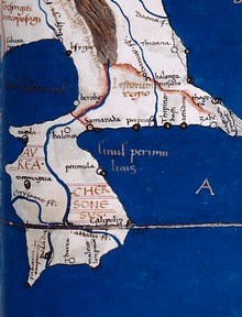
285:
262:
18:
1310:
1272:
1221:
1170:
1146:
1134:
1043:
374:around 1448. It bears the inscription,
134:(the Golden Island or Peninsula, where
1372:
1299:
971:
915:
360:The Golden Chersonese is shown on the
345:beyond the Malay Peninsula being the
182:while excluding the Malay Peninsula.
334:Book of the Description of the Earth
1062:; Goh Geok Yian (14 October 2016).
564:, with many scholars placing it in
13:
540:as one of the places conquered by
14:
1411:
1088:
722:
1114:. Scarecrow Press. p. 107.
996:Choong En Han (March 16, 2014).
341:, with the eastern limit of the
1293:
1176:
1101:
1082:
1020:
1008:
989:
1015:The Travels of Pedro Teixeira,
936:
921:
892:
872:"Gold in early Southeast Asia"
863:
493:
154:. Greek and Roman geographers
1:
828:
670:– various sites ranging from
552:from the 3rd to 11th century.
272:
1108:Ooi Keat Gin (7 June 2010).
931:Volume 16, 1869, pp.638-648.
86:, was the name used for the
7:
1380:Geography of Southeast Asia
885:10.4000/archeosciences.2072
870:Anna T. N. Bennett (2009).
759:
92:Greek and Roman geographers
27:'s 1467 copy of a map from
10:
1416:
1355:University of Malaya Press
803:Greece–Indonesia relations
378:(here lived King Caspar).
67:
808:Greece–Malaysia relations
438:
396:, located the islands of
1095:University of St Andrews
477:by a number of scholars.
376:hic rex caspar habitavit
138:might refer to either a
122:, there are mentions of
1395:Ancient Greek geography
813:Mainland Southeast Asia
686:, or somewhere between
461:, or further south the
355:Dragon's Tail peninsula
259:Cartographic references
215:, based on the work by
192:, however, referred to
111:
1300:Gerini, G. E. (1909).
1111:The A to Z of Malaysia
1065:Ancient Southeast Asia
950:Chapter 6, pp.184-185.
797:Great Golden Peninsula
536:mentioned in the 1030
473:river, proposed to be
420:Geographical locations
312:
298:
283:
79:
51:
1137:, pp. 86, 88–91.
546:invasion of Srivijaya
304:
289:
266:
22:
1341:on 25 February 2017.
1311:Linehan, W. (1951).
786:Sino-Roman relations
755:have been suggested.
743:gulf – possibly the
166:had written about a
160:Dionysius Periegetes
1287:, pp. 153–154.
1263:, pp. 154–155.
1248:, pp. 152–153.
1212:, pp. 151–152.
1161:, pp. 268–272.
986:, pp. 131–136.
962:, pp. 128–129.
860:, pp. 177–184.
848:, pp. 138–159.
818:History of Malaysia
630:, or just south of
560:– a place near the
538:Tanjore inscription
427:Ptolemy's Geography
347:Island of the Jewel
267:The world map from
229:Marcian of Heraclea
148:Alexander the Great
128:(Land of Gold) and
98:, most famously in
96:classical antiquity
1400:Historical regions
1060:John Norman Miksic
658:– suggested to be
394:geographical globe
368:Andreas Walsperger
313:
299:
295:Andreas Walsperger
284:
72:Chrysḗ Chersónēsos
52:
1224:, pp. 92–93.
1173:, pp. 91–92.
1046:, pp. 86–98.
918:, pp. 78–79.
672:Chumphon Province
662:by a few authors.
398:Chryse and Argyre
390:Martin of Bohemia
306:Martin of Bohemia
251:, for example in
245:Godinho de Erédia
80:Chersonesus Aurea
60:Golden Khersonese
56:Golden Chersonese
25:Nicolaus Germanus
1407:
1366:
1353:. Kuala Lumpur:
1342:
1340:
1334:. Archived from
1317:
1307:
1288:
1282:
1276:
1270:
1264:
1258:
1249:
1243:
1237:
1231:
1225:
1219:
1213:
1207:
1201:
1200:
1189:. Penerbit USM.
1180:
1174:
1168:
1162:
1156:
1150:
1144:
1138:
1132:
1126:
1125:
1105:
1099:
1098:
1086:
1080:
1079:
1056:
1047:
1041:
1035:
1026:E.W. Dahlgren, “
1024:
1018:
1012:
1006:
1005:
993:
987:
981:
975:
969:
963:
957:
951:
940:
934:
925:
919:
913:
907:
896:
890:
889:
887:
867:
861:
855:
849:
843:
706:, the deltas of
414:Pedro de Unamuno
325:Arab geographers
277:
274:
100:Claudius Ptolemy
84:Golden Peninsula
69:
68:Χρυσῆ Χερσόνησος
48:Tropic of Cancer
1415:
1414:
1410:
1409:
1408:
1406:
1405:
1404:
1385:Malay Peninsula
1370:
1369:
1338:
1315:
1296:
1291:
1283:
1279:
1271:
1267:
1259:
1252:
1244:
1240:
1232:
1228:
1220:
1216:
1208:
1204:
1197:
1181:
1177:
1169:
1165:
1157:
1153:
1145:
1141:
1133:
1129:
1122:
1106:
1102:
1089:Mintz, Daniel.
1087:
1083:
1076:
1057:
1050:
1042:
1038:
1025:
1021:
1013:
1009:
994:
990:
982:
978:
970:
966:
958:
954:
941:
937:
926:
922:
914:
910:
897:
893:
868:
864:
856:
852:
844:
835:
831:
823:Malay Peninsula
762:
725:
712:Trengganu River
496:
441:
422:
382:was one of the
351:Sea of Darkness
343:inhabited world
291:Aurea Cersonese
275:
261:
189:Natural History
184:Pliny the Elder
114:
102:'s 2nd-century
88:Malay Peninsula
82:), meaning the
36:Malay Peninsula
17:
12:
11:
5:
1413:
1403:
1402:
1397:
1392:
1387:
1382:
1368:
1367:
1347:Wheatley, Paul
1343:
1326:(III): 86–98.
1308:
1295:
1292:
1290:
1289:
1277:
1265:
1250:
1238:
1236:, p. 156.
1226:
1214:
1202:
1195:
1175:
1163:
1151:
1139:
1127:
1120:
1100:
1081:
1074:
1048:
1036:
1019:
1007:
988:
976:
964:
952:
935:
920:
908:
900:Isle of Chryse
891:
878:(33): 99–107.
876:Archeosciences
862:
850:
832:
830:
827:
826:
825:
820:
815:
810:
805:
800:
793:
788:
783:
778:
773:
768:
761:
758:
757:
756:
735:
724:
723:Other features
721:
720:
719:
695:
675:
663:
651:
643:
609:
574:Kinta District
553:
542:Rajendra Chola
534:Talaittakkōlam
495:
492:
491:
490:
478:
466:
440:
437:
421:
418:
392:, on his 1492
260:
257:
164:Pomponius Mela
113:
110:
15:
9:
6:
4:
3:
2:
1412:
1401:
1398:
1396:
1393:
1391:
1388:
1386:
1383:
1381:
1378:
1377:
1375:
1364:
1360:
1356:
1352:
1348:
1344:
1337:
1333:
1329:
1325:
1321:
1314:
1309:
1305:
1304:
1298:
1297:
1286:
1285:Wheatley 1961
1281:
1275:, p. 97.
1274:
1269:
1262:
1261:Wheatley 1961
1257:
1255:
1247:
1246:Wheatley 1961
1242:
1235:
1234:Wheatley 1961
1230:
1223:
1218:
1211:
1210:Wheatley 1961
1206:
1198:
1196:9789674610234
1192:
1188:
1187:
1179:
1172:
1167:
1160:
1159:Wheatley 1961
1155:
1149:, p. 88.
1148:
1143:
1136:
1131:
1123:
1121:9781461671992
1117:
1113:
1112:
1104:
1096:
1092:
1085:
1077:
1075:9781317279037
1071:
1068:. Routledge.
1067:
1066:
1061:
1055:
1053:
1045:
1040:
1033:
1029:
1023:
1016:
1011:
1003:
1002:Media Checker
999:
992:
985:
984:Wheatley 1961
980:
974:, p. 78.
973:
968:
961:
960:Wheatley 1961
956:
949:
945:
939:
933:
930:
924:
917:
912:
905:
904:Chryse Island
901:
895:
886:
881:
877:
873:
866:
859:
858:Wheatley 1961
854:
847:
846:Wheatley 1961
842:
840:
838:
833:
824:
821:
819:
816:
814:
811:
809:
806:
804:
801:
798:
794:
792:
789:
787:
784:
782:
779:
777:
774:
772:
769:
767:
764:
763:
754:
750:
746:
742:
741:
736:
733:
732:
727:
726:
717:
716:Redang Island
713:
709:
705:
701:
700:
696:
693:
689:
688:Kemaman River
685:
681:
680:
676:
673:
669:
668:
664:
661:
657:
656:
652:
649:
648:
644:
641:
638:, as well as
637:
633:
629:
625:
621:
620:
615:
614:
610:
607:
606:Gangga Negara
603:
599:
595:
594:kolong-kolong
591:
587:
583:
579:
575:
571:
570:Kuala Kangsar
567:
563:
559:
558:
554:
551:
547:
543:
539:
535:
531:
530:
529:Milinda Panha
525:
524:
519:
515:
511:
508:, located at
507:
503:
502:
498:
497:
488:
484:
483:
479:
476:
472:
471:
467:
464:
460:
456:
452:
451:
447:
446:
445:
436:
433:
432:Mediterranean
429:
428:
417:
415:
411:
407:
403:
399:
395:
391:
387:
385:
381:
377:
373:
369:
365:
364:
358:
356:
352:
348:
344:
340:
336:
335:
330:
326:
322:
318:
311:
307:
303:
296:
292:
288:
281:
270:
265:
256:
254:
250:
246:
242:
238:
234:
230:
226:
222:
218:
214:
213:
207:
205:
201:
197:
196:
191:
190:
185:
181:
177:
176:Chryse Insula
173:
169:
165:
161:
157:
153:
149:
145:
141:
137:
133:
132:
127:
126:
121:
120:
109:
107:
106:
101:
97:
93:
89:
85:
81:
77:
73:
65:
64:Ancient Greek
61:
57:
49:
45:
41:
37:
33:
32:
26:
23:Details from
21:
1350:
1336:the original
1323:
1319:
1302:
1294:Bibliography
1280:
1273:Linehan 1951
1268:
1241:
1229:
1222:Linehan 1951
1217:
1205:
1185:
1178:
1171:Linehan 1951
1166:
1154:
1147:Linehan 1951
1142:
1135:Linehan 1951
1130:
1110:
1103:
1094:
1084:
1064:
1044:Linehan 1951
1039:
1031:
1022:
1014:
1010:
1001:
991:
979:
967:
955:
947:
943:
938:
928:
923:
911:
903:
899:
894:
875:
865:
853:
781:Suvarnabhumi
745:Gulf of Siam
739:
738:
731:Maleou-kolon
730:
729:
698:
697:
678:
677:
666:
665:
654:
653:
646:
645:
618:
617:
612:
611:
601:
597:
593:
561:
556:
555:
549:
533:
527:
523:Maha Niddesa
521:
517:
504:– a trading
500:
499:
487:Pahang River
481:
480:
469:
468:
459:Bernam River
449:
448:
442:
435:introduced.
425:
423:
388:
375:
361:
359:
339:World Oceans
332:
329:al-Khwārizmī
321:Indian Ocean
314:
290:
224:
210:
208:
193:
187:
175:
171:
167:
156:Eratosthenes
152:Roman Empire
135:
131:Suvarnadvipa
129:
125:Suvarnabhumi
123:
117:
115:
103:
83:
71:
59:
55:
53:
30:
972:Gerini 1909
916:Gerini 1909
740:Perimulikos
660:Kota Tinggi
634:, or south
557:Konkonagara
494:Settlements
475:Johor River
455:Perak River
363:mappa mundi
276: 1300
269:Urb. Gr. 82
255:in Pahang.
233:Lower Burma
168:Golden Isle
1374:Categories
829:References
679:Kole polis
578:Muda River
562:Khrysoanas
463:Muar River
450:Khrysoanas
410:Marco Polo
384:Three Magi
280:Great Gulf
209:Ptolemy's
200:promontory
198:as both a
29:Ptolemy's
1363:504030596
906:, &c.
776:Kattigara
640:Singapore
588:opposite
572:, in the
568:(e.g. at
416:in 1587.
372:Constance
225:Geography
212:Geography
140:peninsula
105:Geography
31:Geography
1349:(1961).
1332:41503002
760:See also
753:Songkhla
749:Tale Sap
708:Kelantan
699:Perimula
684:Kelantan
626:or near
624:Selangor
598:kekolong
584:, or in
514:Takua Pa
506:emporion
470:Palandas
370:made in
310:Erdapfel
297:, c.1448
119:Ramayana
40:Malaysia
1390:Ptolemy
692:Kuantan
667:Kalonka
655:Palanda
632:Malacca
544:in his
518:Takkola
482:Attabas
457:or the
402:Zipangu
349:in the
317:Ptolemy
217:Marinus
202:and an
180:Sumatra
44:Equator
1361:
1330:
1193:
1118:
1072:
791:Serica
766:Cathay
714:, and
647:Tharra
619:Sabana
613:Sabara
602:negara
600:) and
590:Phuket
550:Takola
501:Takola
439:Rivers
380:Caspar
241:Pahang
237:Patani
204:island
195:Chryse
172:Khrysē
162:, and
144:island
142:or an
1339:(PDF)
1328:JSTOR
1316:(PDF)
771:Daqin
728:Cape
704:Ligor
636:Johor
628:Klang
586:Krabi
582:Kedah
566:Perak
510:Trang
406:Japan
249:mined
136:dvipa
76:Latin
1359:OCLC
1324:xxiv
1191:ISBN
1116:ISBN
1070:ISBN
737:The
690:and
596:(or
526:and
253:Raub
239:and
221:Tyre
112:Name
54:The
1030:”,
880:doi
751:in
710:or
616:or
580:in
366:of
308:'s
219:of
186:in
94:in
90:by
58:or
38:of
1376::
1357:.
1322:.
1318:.
1253:^
1093:.
1051:^
1000:.
902:,
874:.
836:^
357:.
331:,
273:c.
206:.
174:,
158:,
108:.
78::
74:;
70:,
66::
1365:.
1199:.
1124:.
1097:.
1078:.
1004:.
888:.
882::
795:"
718:.
694:.
642:.
608:.
489:.
465:.
404:(
282:.
170:(
62:(
Text is available under the Creative Commons Attribution-ShareAlike License. Additional terms may apply.