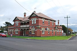
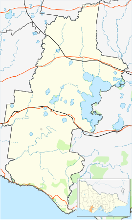
55:
586:
385:
39:
265:
424:
62:
276:
people – held ceremonies, bartered goods and settled disputes. There are conflicting reports about the number of
Indigenous people living in the district at the time of white settlement, but in 1841, the population of the Mount Noorat clan numbered only four people. An outbreak of
238:, Noorat had a population of 252. By 2011, according to the census, the population had dropped to 167, although this drop in numbers is a bit deceptive as the town boundary was changed in between the 2006 and 2011 census.
303:
and the establishment of
Glenormiston. Noorat ostensibly grew as a service centre for the Black family estate and many of the early residents either emigrated with Niel Black or worked at Glenormiston.
253:
elder, Ngoora. Europeans first settled the Noorat area in early 1839 when MacKillop and Smith established a run called
Strathdownie – which was renamed Glenormiston by Niel Black, a
771:
763:
909:
899:
781:
750:
740:
950:
894:
804:
649:
626:
855:
704:
696:
683:
827:
665:
329:
960:
863:
281:
during the 1830s was one cause of the population decline and it has been suggested that an alleged massacre of
Indigenous people by white settlers was another.
889:
837:
735:
657:
644:
945:
922:
914:
608:
868:
850:
845:
822:
786:
758:
730:
673:
631:
455:
198:
186:
970:
965:
935:
881:
809:
621:
616:
927:
832:
814:
799:
776:
904:
725:
54:
339:
Noorat has a local football team, the Kolora-Noorat Power, who merged in 2002 from the Noorat
Bombers and Kolora Magpies. They compete in the
340:
87:
448:
398:
1020:
441:
1010:
990:
272:
Prior to
European settlement, the area near Mount Noorat was a traditional meeting site where Indigenous tribes – the
311:
318:
363:
191:
1015:
333:
328:, which houses the year 7 and 8 students of the school. There is also the senior campus at Camperdown. The
174:
80:
367:
246:
585:
873:
285:
791:
536:
428:
258:
940:
546:
528:
499:
489:
325:
284:
Frederick Taylor, MacKillop and Smith's manager at
Strathdownie was responsible for one of the
250:
131:
123:
235:
494:
717:
709:
541:
479:
465:
336:
is located a few kilometres north-east of the township, on the other side of the mountain.
215:
8:
636:
433:
384:
307:
The post office opened on 1 August 1874 as Mount Noorat, and was renamed Noorat in 1875.
203:
678:
600:
575:
559:
551:
515:
179:
955:
745:
688:
567:
520:
507:
484:
165:
29:
317:
There is currently one place of public worship in Noorat, the Neil Black
Memorial
289:
254:
292:(once known as Taylor's River) near Noorat in August 1839. This was verified by
324:
The township has two schools, Noorat
Primary School, and the Noorat campus of
1004:
273:
102:
89:
242:
227:
159:
38:
300:
293:
264:
234:, which is considered to have Australia's largest dry crater. At the
223:
219:
147:
278:
231:
153:
423:
362:
299:
The settlement history of Noorat is closely linked with the
463:
296:, who found a mass grave on the Glenormiston property.
222:. Noorat is located approximately 211 km west of
288:
in the western district of
Victoria somewhere along
396:
1002:
314:, was born in Noorat's general store, in 1902.
261:in Argyll who purchased the property in 1840.
449:
343:. Their colours are teal, black and white.
456:
442:
383:
341:Warrnambool & District Football League
37:
268:Walkers on the crater rim of Mount Noorat
226:. The township is located at the base of
263:
1003:
245:, a dormant volcano named by explorer
437:
358:
356:
214:is a small township in southwestern
13:
353:
14:
1032:
417:
584:
422:
390:
146:211 km (131 mi) SW of
60:
53:
989:Territory divided with another
364:Australian Bureau of Statistics
158:52 km (32 mi) NE of
152:145 km (90 mi) W of
61:
1:
346:
241:Noorat derives its name from
334:South West Institute of TAFE
7:
1021:Western District (Victoria)
164:8 km (5 mi) N of
18:Town in Victoria, Australia
10:
1037:
1011:Towns in Victoria (state)
982:
593:
582:
472:
197:
185:
173:
140:
130:
118:
79:
48:
36:
23:
397:Premier Postal History,
257:-speaking Scotsman from
372:2011 Census QuickStats
326:Mercy Regional College
269:
103:38.18333°S 142.93333°E
431:at Wikimedia Commons
267:
247:Major Thomas Mitchell
1016:Shire of Corangamite
466:Shire of Corangamite
108:-38.18333; 142.93333
366:(31 October 2012).
199:Federal division(s)
187:State electorate(s)
99: /
772:Glenormiston South
764:Glenormiston North
464:Localities in the
270:
43:Mount Noorat Hotel
998:
997:
427:Media related to
209:
208:
180:Corangamite Shire
1028:
910:South Purrumbete
900:Pomborneit North
782:Heytesbury Lower
751:Gellibrand Lower
741:Elingamite North
588:
458:
451:
444:
435:
434:
426:
411:
410:
409:
407:
400:Post Office List
394:
388:
387:
382:
380:
378:
360:
114:
113:
111:
110:
109:
104:
100:
97:
96:
95:
92:
64:
63:
57:
41:
32:
26:
21:
20:
1036:
1035:
1031:
1030:
1029:
1027:
1026:
1025:
1001:
1000:
999:
994:
978:
951:Vite Vite North
895:Pomborneit East
589:
580:
468:
462:
420:
415:
414:
405:
403:
395:
391:
376:
374:
361:
354:
349:
290:Mount Emu Creek
286:worst massacres
107:
105:
101:
98:
93:
90:
88:
86:
85:
75:
74:
73:
72:
71:
70:
69:
65:
44:
28:
27:
24:
19:
12:
11:
5:
1034:
1024:
1023:
1018:
1013:
996:
995:
983:
980:
979:
977:
976:
968:
963:
958:
953:
948:
943:
938:
933:
925:
920:
912:
907:
902:
897:
892:
887:
879:
874:Pirron Yallock
871:
866:
861:
853:
848:
843:
835:
830:
825:
820:
812:
807:
805:Kennedys Creek
802:
797:
789:
784:
779:
774:
769:
761:
756:
748:
743:
738:
733:
728:
723:
715:
707:
702:
694:
686:
681:
676:
671:
663:
655:
650:Carlisle River
647:
642:
634:
629:
627:Bostocks Creek
624:
619:
614:
606:
597:
595:
591:
590:
583:
581:
579:
578:
573:
565:
557:
549:
544:
539:
534:
526:
518:
513:
505:
497:
492:
487:
482:
476:
474:
470:
469:
461:
460:
453:
446:
438:
419:
418:External links
416:
413:
412:
389:
351:
350:
348:
345:
310:Noted author,
274:Kirrae Wuurong
249:after a local
207:
206:
201:
195:
194:
189:
183:
182:
177:
171:
170:
169:
168:
162:
156:
150:
142:
138:
137:
134:
128:
127:
120:
116:
115:
83:
77:
76:
67:
66:
59:
58:
52:
51:
50:
49:
46:
45:
42:
34:
33:
17:
9:
6:
4:
3:
2:
1033:
1022:
1019:
1017:
1014:
1012:
1009:
1008:
1006:
993:
992:
986:
981:
975:
972:
969:
967:
964:
962:
959:
957:
954:
952:
949:
947:
944:
942:
939:
937:
934:
932:
929:
926:
924:
921:
919:
916:
913:
911:
908:
906:
903:
901:
898:
896:
893:
891:
888:
886:
883:
880:
878:
875:
872:
870:
867:
865:
862:
860:
857:
856:Nirranda East
854:
852:
849:
847:
844:
842:
839:
836:
834:
831:
829:
826:
824:
821:
819:
816:
813:
811:
808:
806:
803:
801:
798:
796:
793:
792:Jancourt East
790:
788:
785:
783:
780:
778:
775:
773:
770:
768:
765:
762:
760:
757:
755:
752:
749:
747:
744:
742:
739:
737:
734:
732:
729:
727:
724:
722:
719:
716:
714:
711:
708:
706:
705:Curdies River
703:
701:
698:
697:Cundare North
695:
693:
690:
687:
685:
684:Cowleys Creek
682:
680:
677:
675:
672:
670:
667:
664:
662:
659:
656:
654:
651:
648:
646:
643:
641:
638:
635:
633:
630:
628:
625:
623:
620:
618:
615:
613:
610:
607:
605:
602:
599:
598:
596:
592:
587:
577:
574:
572:
569:
566:
564:
561:
558:
556:
553:
550:
548:
545:
543:
540:
538:
537:Port Campbell
535:
533:
530:
527:
525:
522:
519:
517:
514:
512:
509:
506:
504:
501:
498:
496:
493:
491:
488:
486:
483:
481:
478:
477:
475:
471:
467:
459:
454:
452:
447:
445:
440:
439:
436:
432:
430:
425:
402:
401:
393:
386:
373:
369:
365:
359:
357:
352:
344:
342:
337:
335:
331:
327:
322:
320:
315:
313:
312:Alan Marshall
308:
305:
302:
297:
295:
291:
287:
282:
280:
275:
266:
262:
260:
256:
252:
248:
244:
239:
237:
233:
229:
225:
221:
217:
213:
205:
202:
200:
196:
193:
190:
188:
184:
181:
178:
176:
172:
167:
163:
161:
157:
155:
151:
149:
145:
144:
143:
139:
135:
133:
129:
125:
121:
117:
112:
84:
82:
78:
56:
47:
40:
35:
31:
22:
16:
988:
984:
973:
941:Timboon West
930:
917:
884:
876:
858:
840:
828:Leslie Manor
817:
794:
766:
753:
720:
712:
699:
691:
668:
666:Chapple Vale
660:
652:
639:
611:
603:
570:
562:
554:
547:Scotts Creek
531:
529:Peterborough
523:
510:
502:
500:Ecklin South
490:Cooriemungle
421:
404:, retrieved
399:
392:
375:. Retrieved
371:
338:
330:Glenormiston
323:
319:Presbyterian
316:
309:
306:
301:Black family
298:
283:
271:
243:Mount Noorat
240:
230:, a dormant
228:Mount Noorat
211:
210:
15:
961:Wattle Hill
864:Noorat East
495:Derrinallum
236:2006 census
160:Warrnambool
132:Postcode(s)
124:2016 census
106: /
81:Coordinates
1005:Categories
890:Pomborneit
838:Mount Bute
736:Elingamite
718:Darlington
710:Curdievale
658:Carpendeit
645:Bullaharre
542:Princetown
480:Camperdown
347:References
332:campus of
294:Niel Black
251:Indigenous
122:219 (
119:Population
94:142°56′0″E
946:Vite Vite
923:Tandarook
915:Stonyford
637:Brucknell
609:Berrybank
377:8 January
224:Melbourne
220:Australia
148:Melbourne
91:38°11′0″S
869:Paaratte
851:Newfield
846:Naroghid
823:Larralea
787:Jancourt
759:Glenfyne
731:Duverney
674:Chocolyn
632:Bradvale
594:Locality
406:11 April
368:"Noorat"
321:Church.
279:smallpox
216:Victoria
192:Polwarth
141:Location
30:Victoria
971:Werneth
966:Weerite
936:Tesbury
882:Pittong
810:Koallah
679:Cobrico
622:Boorcan
617:Bookaar
601:Ayrford
576:Timboon
560:Skipton
552:Simpson
516:Lismore
232:volcano
154:Geelong
956:Waarre
928:Taroon
833:Mingay
815:Kolora
800:Kariah
777:Gnotuk
746:Foxhow
689:Cressy
568:Terang
521:Noorat
508:Garvoc
485:Cobden
429:Noorat
259:Cowall
255:Gaelic
212:Noorat
204:Wannon
175:LGA(s)
166:Terang
68:Noorat
25:Noorat
905:Skibo
726:Dixie
473:Town
408:2008
379:2014
136:3265
991:LGA
1007::
987:-
370:.
355:^
218:,
985:^
974:^
931:^
918:^
885:^
877:^
859:^
841:^
818:^
795:^
767:^
754:^
721:^
713:^
700:^
692:^
669:^
661:^
653:^
640:^
612:^
604:^
571:^
563:^
555:^
532:^
524:^
511:^
503:^
457:e
450:t
443:v
381:.
126:)
Text is available under the Creative Commons Attribution-ShareAlike License. Additional terms may apply.


