370:
210:
217:
27:
42:
198:
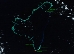
of 382 square kilometers (147 sq mi). The eastern portion of the reef is deeply submerged. Its total land area of the nine islets is only 0.4 square kilometers (0.15 sq mi). Nugulu is located approximately 104 kilometers (65 mi) south-southwest of
445:
440:
163:
67:
411:
256:
230:
350:
291:
194:. Ngulu extends for 36 kilometers (22 mi) by 22 kilometers (14 mi) with 18 reef segments enclosing a deep central
209:
322:
404:
435:
377:
295:
191:
138:
203:
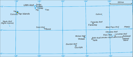
and is the westernmost atoll in the
Federated States of Micronesia. The population of Ngulu was 26 in 2000.
397:
287:
430:
369:
8:
279:
245:
385:
267:
179:
354:
271:
381:
263:
424:
183:
82:
69:
283:
275:
175:
187:
244:
First recorded sighting of Ngulu Atoll was by the
Spanish navigator
249:
195:
262:
As with all of the
Caroline Islands, sovereignty was sold by
31:
16:
Pacific atoll in Yap State, Federated States of
Micronesia
200:
26:
255:. In 1802 it was explored by Spanish naval officer Don
41:
270:in 1899. The island came under the control of the
422:
446:Federated States of Micronesia geography stubs
278:, and was subsequently administered under the
405:
441:Atolls of the Federated States of Micronesia
286:, the island came under the control of the
412:
398:
40:
423:
335:The discovery of the Pacific Islands
292:Trust Territory of the Pacific Islands
234:Location of Ngulu in the Pacific Ocean
186:, and forms a legislative district in
364:
290:and was administered as part of the
248:on 23 January 1565 on board of the
13:
294:from 1947, and became part of the
118:0.4 km (0.15 sq mi)
14:
457:
357: (archived December 23, 2010)
344:
368:
215:
208:
25:
308:Columbia Gazetteer of the World
378:Federated States of Micronesia
327:
316:
296:Federated States of Micronesia
192:Federated States of Micronesia
139:Federated States of Micronesia
1:
301:
216:
384:. You can help Knowledge by
7:
10:
462:
363:
239:
159:
151:
146:
135:
130:
122:
114:
106:
98:
61:
53:
48:
39:
24:
288:United States of America
178:of three islands in the
380:location article is a
351:Entry at Oceandots.com
123:Highest elevation
34:picture of Ngulu Atoll
436:Municipalities of Yap
310:. Vol. 1, p. 900
231:class=notpageimage|
126:2 m (7 ft)
337:Oxford, 1960, p.36.
79: /
21:
323:2000 census of Yap
280:South Seas Mandate
246:Alonso de Arellano
19:
393:
392:
268:Empire of Germany
169:
168:
83:8.450°N 137.483°E
453:
414:
407:
400:
372:
365:
338:
331:
325:
320:
219:
218:
212:
180:Caroline Islands
94:
93:
91:
90:
89:
84:
80:
77:
76:
75:
72:
44:
29:
22:
18:
461:
460:
456:
455:
454:
452:
451:
450:
421:
420:
419:
418:
361:
355:Wayback Machine
347:
342:
341:
332:
328:
321:
317:
304:
272:Empire of Japan
242:
237:
236:
235:
233:
227:
226:
225:
224:
220:
142:
87:
85:
81:
78:
73:
70:
68:
66:
65:
35:
17:
12:
11:
5:
459:
449:
448:
443:
438:
433:
431:Islands of Yap
417:
416:
409:
402:
394:
391:
390:
373:
359:
358:
346:
345:External links
343:
340:
339:
333:Sharp, Andrew
326:
314:
313:
312:
311:
303:
300:
241:
238:
229:
228:
222:
221:
214:
213:
207:
206:
205:
167:
166:
161:
157:
156:
153:
149:
148:
144:
143:
136:
133:
132:
131:Administration
128:
127:
124:
120:
119:
116:
112:
111:
108:
104:
103:
100:
96:
95:
88:8.450; 137.483
63:
59:
58:
55:
51:
50:
46:
45:
37:
36:
30:
15:
9:
6:
4:
3:
2:
458:
447:
444:
442:
439:
437:
434:
432:
429:
428:
426:
415:
410:
408:
403:
401:
396:
395:
389:
387:
383:
379:
374:
371:
367:
366:
362:
356:
352:
349:
348:
336:
330:
324:
319:
315:
309:
306:
305:
299:
297:
293:
289:
285:
281:
277:
273:
269:
265:
260:
258:
254:
251:
247:
232:
211:
204:
202:
197:
193:
189:
185:
184:Pacific Ocean
181:
177:
173:
165:
162:
160:Ethnic groups
158:
154:
150:
145:
141:
140:
134:
129:
125:
121:
117:
113:
109:
107:Total islands
105:
101:
97:
92:
64:
60:
57:North Pacific
56:
52:
47:
43:
38:
33:
28:
23:
386:expanding it
375:
360:
334:
329:
318:
307:
284:World War II
282:. Following
261:
252:
243:
171:
170:
147:Demographics
137:
298:from 1979.
276:World War I
257:Juan Lafita
176:coral atoll
172:Ngulu Atoll
164:Micronesian
99:Archipelago
86: /
62:Coordinates
425:Categories
302:References
152:Population
253:San Lucas
188:Yap State
155:26 (2000)
49:Geography
102:Caroline
74:137°29′E
54:Location
353:at the
266:to the
250:patache
240:History
190:in the
182:in the
274:after
196:lagoon
71:8°27′N
376:This
264:Spain
223:Ngulu
174:is a
20:Ngulu
382:stub
115:Area
32:NASA
201:Yap
427::
259:.
413:e
406:t
399:v
388:.
110:9
Text is available under the Creative Commons Attribution-ShareAlike License. Additional terms may apply.


