260:
148:
731:
141:
306:
29:
410:
CAI carried out in parallel the construction work, on the part of the land that was the
Vittorio Emanuele II refuge, of the Falco Maiorano bivouac, named after the club's mountain guide of the same name. However, the new construction was short-lived: it was completely swept away by a severe blizzard
401:
In 1964 the Ciro
Manzini refuge was built on the upper part of the Cinnamon Valley, but still on Mount Amaro, named after the Farese mountaineer who in 1937 was the first to reach the summit of the Murelle and who perished on 23 December 1940, while fighting on the Greek-Albanian front during World
271:
massif, surrounded to the north by Mount Pesco
Falcone, to the northeast by Mount Tre Portoni, to the east by the Altare peak, and to the south by Mount Macellaro, to which it is separated by the Femmina Morta valley. More precisely, it is located on the western slope of the massif, which descends
418:
aviators, began construction work on the Cesare Mario Pelino bivouac, which would end the following year, with the new structure then being inaugurated on 18 July 1982 and named after one of the members of a well-known
Sulmona confectionery.
385:
massif, was occupied by the
Germans, intent on thwarting the moves of the Allies, who equipped the area with anti-aircraft guns and the construction there of an observatory and a cable car that allowed them to reach the peak from
276:
and San
Leonardo Pass. The eastern slope, on the other hand, overlooks the various scattered mountains to the northwest, including Mount Acquaviva, separated by valleys and deep gorges, and the valleys of
335:
In the 11th century, excavations were carried out in the depths of the mount to extract marbles and stones that were used in the construction of the columns found in a chapel of the
332:, which, as the language changed over time, was altered to the name in use, which, like the previous name, refers to the ruggedness that characterizes its summit.
398:, already heavily damaged by the partisans, would be finally demolished by the Germans themselves on 7 June 1945, as the outcome of the war worsened.
97:
704:
390:. The funicular was noticed by the partisans of the Maiella Brigade, who initiated actions to spoil the cable car and had British
470:. The direct routes bear the name "rava", a term for a landslide gully made of stony debris that descends between two slopes.
336:
752:
140:
394:
bomb the
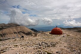
Germans positioned on the summit, leading to the destruction of the Vittorio Emanuele II shelter. The
762:
90:
757:
414:
In 1981, with a completely different project from the previous ones, the CAI of
Sulmona, assisted by the
347:
83:
583:
439:
708:
431:
403:
194:
244:
58:
561:
544:
455:
354:" and privately owned by Giuseppe Andrea Angeloni, was acquired in 1890 by donation from the
68:
767:
606:
539:
537:
459:
391:
355:
645:
Alesi & Calibani (2007), p. 23; Istituto
Poligrafico e Zecca dello Stato (1949), p. 7.
8:
534:
463:
259:
363:
240:
189:
78:
329:
669:
736:
489:
278:
177:
285:
to the east and southeast, respectively. On the summit is the Cesare Mario Pelino
655:
494:
294:
286:
282:
517:
713:. Vol. 1ª parte, anno 90º. Roma: Istituto Poligrafico e Zecca dello Stato.
467:
427:
387:
367:
201:
746:
112:
99:
362:
to build in the same year the
Vittorio Emanuele II refuge, dedicated to the
378:
309:
248:
351:
325:
305:
28:
415:
395:
208:
703:
547:(2020), north sheet (back); Peakbagger.com; Sapere.it; Treccani.it.
484:
435:
343:
273:
225:
690:. Vol. 4, 1ª parte. Milano: Giuseppe Civelli & Co. 1852.
479:
407:
382:
268:
236:
229:
212:
182:
34:
371:
232:
48:
321:
290:
170:
359:
717:
324:
meaning of "Bad Mount", as documented in a 13th-century
297:, with the Ciro Manzini refuge below on the north side.
632:
630:
628:
726:
625:
267:
The mountain occupies a central position within the
263:
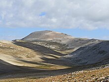
Mount Amaro as seen from the valley of Femmina Morta
744:
578:
576:
574:
572:
570:
688:Dizionario corografico-universale dell'Italia
710:Gazzetta Ufficiale della Repubblica Italiana
694:
567:
430:to reach the summit include the so-called "
406:. Also in the same year and until 1966 the
695:Alberico Alesi; Maurizio Calibani (2007).
37:, with the red bivouac Cesare Mario Pelino
705:Istituto Poligrafico e Zecca dello Stato
422:
312:placed on the highest point of Mt. Amaro
304:
258:
699:. Folignano: Società Editrice Ricerche.
342:The peak of Mount Amaro, listed in the
33:Summit of Mount Amaro, highest peak of
745:
718:Parco nazionale della Maiella (2020).
720:Carta escursionistica. Scala 1:25.000
557:
555:
553:
512:
510:
337:hermitage of Santo Spirito a Majella
596:Alesi & Calibani (2007), p. 23.
370:, later sold in 1937 to the CAI of
316:Mount Amaro was originally called "
147:
13:
550:
438:, at Passo San Leonardo, and from
239:region and the entire continental
14:
779:
507:
402:War II, being awarded the silver
293:, painted red and containing the
729:
466:, some of them via Blockhaus or
146:
139:
27:
680:
662:
648:
636:Alesi e Calibani (2007), p. 76.
381:, the peak, like others in the
224:(2793 m a.s.l.) is the highest
639:
613:
599:
590:
377:In the spring of 1945, during
254:
235:and the second highest in the
1:
670:"Sentiero B5: rava del ferro"
500:
73:60.18 km (37.39 mi)
63:1,810 m (5,940 ft)
53:2,793 m (9,163 ft)
7:
686:
619:
584:"Storia del Bivacco Pelino"
564:(2020), north sheet (back).
473:
454:"), as well as some hybrid
348:Kingdom of the Two Sicilies
10:
784:
448:rava della giumenta bianca
434:" routes that ascend from
350:as "productive pasture or
300:
16:Mountain in Abruzzo, Italy
200:
188:
176:
166:
133:
128:
89:
77:
67:
57:
47:
42:
26:
21:
753:Two-thousanders of Italy
722:. Pistoia: DREAm Italia.
697:Majella Parco Nazionale
404:medal of military valor
113:42.086332°N 14.085911°E
440:Sant'Eufemia a Maiella
313:
264:
562:Maiella National Park
545:Maiella National Park
456:Maiella National Park
428:Mountaineering routes
423:Mountaineering routes
308:
262:
763:Mountains of Abruzzo
518:"Monte Amaro, Italy"
118:42.086332; 14.085911
543:Abruzzoturismo.it;
464:Grand Italian Trail
109: /
758:Mountains of Italy
707:(3 January 1949).
607:"Fara San Martino"
314:
265:
84:Mountains of Italy
43:Highest point
330:Pope Honorius III
289:, shaped like an
219:
218:
775:
739:
737:Mountains portal
734:
733:
732:
723:
714:
700:
691:
674:
673:
666:
660:
659:
652:
646:
643:
637:
634:
623:
617:
611:
610:
603:
597:
594:
588:
587:
580:
565:
559:
548:
541:
532:
531:
529:
528:
514:
490:Fara San Martino
458:trails with the
452:rava della vespa
279:Fara San Martino
204:
150:
149:
143:
124:
123:
121:
120:
119:
114:
110:
107:
106:
105:
102:
31:
19:
18:
783:
782:
778:
777:
776:
774:
773:
772:
743:
742:
735:
730:
728:
683:
678:
677:
668:
667:
663:
654:
653:
649:
644:
640:
635:
626:
618:
614:
605:
604:
600:
595:
591:
582:
581:
568:
560:
551:
542:
535:
526:
524:
516:
515:
508:
503:
495:Taranta Peligna
476:
425:
303:
283:Taranta Peligna
272:steeply toward
257:
202:
162:
161:
160:
159:
158:
157:
156:
155:
151:
117:
115:
111:
108:
103:
100:
98:
96:
95:
38:
17:
12:
11:
5:
781:
771:
770:
765:
760:
755:
741:
740:
725:
724:
715:
701:
692:
682:
679:
676:
675:
661:
647:
638:
624:
612:
598:
589:
566:
549:
533:
522:Peakbagger.com
505:
504:
502:
499:
498:
497:
492:
487:
482:
475:
472:
468:Campo di Giove
444:rava del ferro
424:
421:
388:Campo di Giove
368:House of Savoy
302:
299:
256:
253:
217:
216:
206:
198:
197:
192:
186:
185:
180:
174:
173:
168:
164:
163:
153:
152:
145:
144:
138:
137:
136:
135:
134:
131:
130:
126:
125:
93:
87:
86:
81:
75:
74:
71:
65:
64:
61:
55:
54:
51:
45:
44:
40:
39:
32:
24:
23:
15:
9:
6:
4:
3:
2:
780:
769:
766:
764:
761:
759:
756:
754:
751:
750:
748:
738:
727:
721:
716:
712:
711:
706:
702:
698:
693:
689:
685:
684:
671:
665:
657:
651:
642:
633:
631:
629:
622:, p. 534
621:
616:
608:
602:
593:
585:
579:
577:
575:
573:
571:
563:
558:
556:
554:
546:
540:
538:
523:
519:
513:
511:
506:
496:
493:
491:
488:
486:
483:
481:
478:
477:
471:
469:
465:
461:
457:
453:
449:
445:
441:
437:
433:
429:
420:
417:
412:
409:
405:
399:
397:
393:
389:
384:
380:
375:
373:
369:
365:
364:King of Italy
361:
357:
353:
349:
345:
340:
338:
333:
331:
327:
323:
319:
311:
307:
298:
296:
292:
288:
284:
280:
275:
270:
261:
252:
250:
246:
242:
238:
234:
231:
227:
223:
214:
210:
207:
205:
199:
196:
193:
191:
187:
184:
181:
179:
175:
172:
169:
165:
142:
132:
127:
122:
94:
92:
88:
85:
82:
80:
76:
72:
70:
66:
62:
60:
56:
52:
50:
46:
41:
36:
30:
25:
20:
719:
709:
696:
687:
681:Bibliography
664:
650:
641:
615:
601:
592:
525:. Retrieved
521:
451:
447:
443:
432:direttissime
426:
413:
400:
379:World War II
376:
341:
334:
320:", with the
317:
315:
266:
249:Corno Grande
228:peak in the
221:
220:
203:Parent range
352:fallow land
295:summit book
255:Description
222:Mount Amaro
154:Monte Amaro
116: /
91:Coordinates
22:Monte Amaro
747:Categories
527:2023-07-19
501:References
328:issued by
318:Mons Malus
245:Gran Sasso
104:14°05′09″E
101:42°05′11″N
59:Prominence
656:"Abruzzo"
416:Frosinone
411:in 1974.
396:funicular
392:Spitfires
241:Apennines
209:Apennines
129:Geography
69:Isolation
49:Elevation
768:L'Aquila
485:Pacentro
474:See also
436:Pacentro
344:cadastre
274:Pacentro
243:, after
226:mountain
195:L'Aquila
190:Province
480:Maiella
450:" and "
408:Sulmona
383:Maiella
366:of the
346:of the
301:History
287:bivouac
269:Maiella
237:Abruzzo
230:Maiella
213:Maiella
183:Abruzzo
167:Country
79:Listing
35:Maiella
372:Chieti
233:massif
178:Region
322:Latin
310:Cross
291:igloo
171:Italy
620:1852
446:", "
360:Rome
326:bull
281:and
462:'s
460:CAI
358:of
356:CAI
247:'s
749::
627:^
569:^
552:^
536:^
520:.
509:^
442:("
374:.
339:.
251:.
672:.
658:.
609:.
586:.
530:.
215:)
211:(
Text is available under the Creative Commons Attribution-ShareAlike License. Additional terms may apply.


