317:
bar, accessed by a rock staircase with protection cable. The 2nd
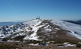
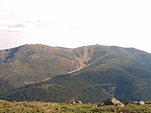
Guarramilla was located at elevation 2210 m and to the W of the 1st, to the left of the concrete track (as we go towards the TV antennas) and topped with a metal cross, although its highest point is a small rock promontory a few meters further to the E. The 3rd Guarramilla is the highest, it is located to the ESE of the 2nd and in its summit plain the TV antennas are located; it has a geodesic vertex of the IGN at 2262m according to Cayetano E. de S. (to the S of the TV installations). Finally the 4th Guarramilla is a small projection seen from the N, and a plain approaching from the 3rd, and to the NNE of this one; about 300 m from this last one, Cayetano said to be at 2246 m. On the summit plateau an old rain gauge has been "recycled" as an information panel of the surrounding summits. To the N and at the foot of this elevation we can see the cone where the Valdesquí alpine ski resort is located. With the progress and improvement of current measuring equipment, the elevations cited by Cayetano E. de Salamanca are those corresponding to 2179 m, 2227 m, 2258 m, and 2248 m of the 1st, 2nd, 3rd and 4th Guarramillas according to the IGN maps in their latest editions.
29:
357:
337:
232:
309:
203:), whose emissions began with an image of the globe and on it, in the center of Spain, appeared some rocket-shaped antennas that emitted semicircular waves, motivating that this name was given to the place where the television signal came from, whose toponym is Alto de Guarramillas. This stop is part of the Guarramas, a group of relief elements located in the surroundings of this mountain. "
348:(1880 m) and ascends the western slope of this mountain, until reaching the summit after approximately 40 minutes of walking. Halfway and at 2170 meters of altitude is Dos Castillas, a place where there is a bar-restaurant and is the head of a chairlift that leaves the Puerto de Navacerrada. It is open in winter and on weekends during the non-ski season, including the summer season.
301:(page 107), a person who was careful with the toponymy of the mountains, described the situation of the four Guarramillas: ".... the Guarramillas, a group of four summits about which there is an evident toponymic confusion, since some of them are called Guarramas, although this name does not exist (already in the 14th century Alfonso XI called them "
364:
At its summit there are antennas, whose function was to broadcast the radio and television signal and send it to the two plateaus. In 2010, the
Spanish Government decided to close the powerful television repeater of Navacerrada due to the analogical blackout, leaving it exclusively for the FM radio
316:
The same author placed them from W to E, coinciding the 1st
Guarramilla with the elevation 2181 m, is the most rocky and is located in it a sculpture of the Virgen de las Nieves, and the station / upper bar of the chairlift of the Puerto de Navacerrada; its highest point is attached and behind the
394:
and arrived after almost 169 km with four scoring difficulties, one third category, two first category and the summit of the Bola del Mundo of special category, at 2250 m. The winner of this stage and therefore the first winner at the top of the Bola del Mundo was
198:
The origin of the name is recent, since it appeared with the installation of the television and radio signal repeater antennas in 1959. At the time of the installation of these repeater antennas there was only one television channel in Spain
372:
in the shape of a rocket to protect them from the ice. They are visible from several kilometers around and constitute the greatest peculiarity of this mountain, which is easily accessible from the
420:. The climb has an average gradient of 6.1% over the 22 km of ascent, although some ramps reach 20%, making it one of the toughest climbs in the national and international cycling calendar.
290:
390:, the Bola del Mundo was a stage finish for the first time in the history of the race. Specifically, the 20th stage, which took place on Saturday, September 18, 2010, started from
503:
320:
The route starts at the
Navacerrada pass, climbs to the Alto de las Guarramillas, begins the descent at the source of the Manzanares River and, after a long descent, reaches
407:, although months later the National Court annulled the sanction, the victory is still invalidated by the UCI; entering the finish followed by 1 second by the winner of the
448:
280:
183:
256:
263:(1858 m) and to the east the rest of Cuerda Larga. To the north of the summit there is a small mountainous branch, called Loma del Noruego, which separates the
236:
268:
453:
244:
179:
71:
553:
279:
ski resort is located on its western slopes. Near its summit, at an altitude of 2000 meters and on its southeastern slope, is the
538:
365:
broadcasting of RNE 1 Madrid (104.9 MHz) RNE-CLAS (98.8 MHz), RNE Radio 3 (95.8 MHz) and Onda Madrid (106.0 MHz).
391:
579:
64:
178:. It has an altitude of 2257 meters with a prominence of 103 meters, and is the westernmost summit of the
589:
584:
200:
594:
424:
408:
386:
54:
271:, to the east. In the vicinity of the summit, on the northeastern slope, is the ski resort of
504:"Bola del Mundo 2.258 m desde Puerto Navacerrada descenso por Barranco Arroyo de los Puentes"
135:
248:
216:
155:
8:
400:
171:
167:
477:
28:
321:
284:
220:
187:
344:
The quickest access to the summit is by a hard concrete forest track, which starts at
534:
396:
163:
373:
345:
276:
260:
458:
417:
404:
159:
115:
356:
340:
Southwest side of the Bola del Mundo as seen from the viewpoint of Las
Canchas.
264:
108:
573:
432:
336:
86:
73:
294:
283:, a place where there are several water springs that are the source of the
252:
127:
272:
325:
423:
The Bola del Mundo was climbed again in the penultimate stage of the
403:
team, but then the UCI annulled his victory for an alleged case of
231:
186:, an area with water emanations that constitutes the source of the
182:
mountain range. Very close to the summit, on the east side, is the
151:
308:
478:"NAVACERRADA-BOLA DEL MUNDO - Altimetrías de Puertos de Montaña"
369:
44:
175:
533:(2nd ed.). Madrid: Ediciones La Librería. p. 188.
190:, and where great thicknesses of snow accumulate in winter.
247:
mountain range and is located in the central area of the
243:
The Bola del Mundo is the westernmost mountain of the
368:These three large antennas are covered by a heated
219:. The antennas are located in the municipality of
207:" is a toponym that comes from the medieval word "
571:
529:Vías, Julio (2002). "Las "Guadarramiellas"".
217:mountain range where the mountain is located
251:, having on its southern slope the peak of
355:
335:
307:
230:
572:
439:was confirmed as the virtual winner.
528:
235:The Bola del Mundo (right) from the
33:Eastern slope of the Bola del Mundo.
13:
14:
606:
565:
431:where the winner was the Russian
27:
360:Antennas of the Bola del Mundo.
134:On the western slope, from the
547:
522:
496:
470:
291:Cayetano Enríquez de Salamanca
1:
554:Profile of the 20th stage in
464:
211:", which in turn comes from "
193:
7:
442:
392:San Martín de Valdeiglesias
351:
312:Snowy view of the mountain.
299:Por la Sierra de Guadarrama
226:
170:, near the border with the
10:
611:
399:, Galician cyclist of the
379:
508:Wikiloc | Rutas del Mundo
449:Ventisquero de la Condesa
331:
281:Ventisquero de la Condesa
184:Ventisquero de la Condesa
126:
121:
107:
102:
63:
53:
43:
38:
26:
21:
148:Alto de las Guarramillas
59:103 m (338 ft)
531:Memorias del Guadarrama
166:. It is located in the
361:
341:
313:
240:
359:
346:Puerto de Navacerrada
339:
311:
277:Puerto de Navacerrada
257:valley of La Barranca
234:
136:Puerto de Navacerrada
580:Sierra de Guadarrama
387:2010 Vuelta a España
249:Sierra de Guadarrama
156:Sierra de Guadarrama
87:40.78500°N 3.98000°W
482:www.altimetrias.net
267:, to the west, and
215:", the name of the
172:province of Segovia
168:Community of Madrid
83: /
590:Mountains of Spain
362:
342:
322:Manzanares el Real
314:
265:valleys of Valsaín
259:, to the west the
241:
221:Manzanares el Real
92:40.78500; -3.98000
39:Highest point
397:Ezequiel Mosquera
293:in his book (now
275:. Similarly, the
255:(2227 m) and the
164:Iberian Peninsula
141:
140:
16:Mountain in Spain
602:
560:
551:
545:
544:
526:
520:
519:
517:
515:
500:
494:
493:
491:
489:
474:
437:Alberto Contador
374:Navacerrada pass
285:Manzanares river
261:Navacerrada pass
188:Manzanares river
130:
111:
98:
97:
95:
94:
93:
88:
84:
81:
80:
79:
76:
31:
19:
18:
610:
609:
605:
604:
603:
601:
600:
599:
595:Sistema Central
585:Vuelta a España
570:
569:
568:
563:
552:
548:
541:
527:
523:
513:
511:
502:
501:
497:
487:
485:
476:
475:
471:
467:
459:Puerto de Cotos
445:
418:Vincenzo Nibali
401:Xacobeo-Galicia
382:
354:
334:
303:Guadarramiellas
237:Peñalara massif
229:
209:Guadarramiellas
196:
160:Sistema Central
128:
116:Sistema Central
109:
91:
89:
85:
82:
77:
74:
72:
70:
69:
34:
17:
12:
11:
5:
608:
598:
597:
592:
587:
582:
567:
566:External links
564:
562:
561:
546:
539:
521:
495:
468:
466:
463:
462:
461:
456:
451:
444:
441:
416:, the Italian
381:
378:
353:
350:
333:
330:
228:
225:
195:
192:
144:Bola del Mundo
139:
138:
132:
124:
123:
119:
118:
113:
105:
104:
100:
99:
67:
61:
60:
57:
51:
50:
47:
41:
40:
36:
35:
32:
24:
23:
22:Bola del Mundo
15:
9:
6:
4:
3:
2:
607:
596:
593:
591:
588:
586:
583:
581:
578:
577:
575:
558:
557:
550:
542:
540:84-89411-72-7
536:
532:
525:
510:(in Galician)
509:
505:
499:
483:
479:
473:
469:
460:
457:
455:
452:
450:
447:
446:
440:
438:
434:
433:Denis Menchov
430:
426:
421:
419:
415:
414:
411:
406:
402:
398:
393:
389:
388:
377:
375:
371:
366:
358:
349:
347:
338:
329:
327:
323:
318:
310:
306:
304:
300:
296:
292:
288:
286:
282:
278:
274:
270:
266:
262:
258:
254:
250:
246:
238:
233:
224:
222:
218:
214:
210:
206:
202:
191:
189:
185:
181:
177:
173:
169:
165:
161:
157:
153:
149:
145:
137:
133:
131:
129:Easiest route
125:
120:
117:
114:
112:
106:
101:
96:
68:
66:
62:
58:
56:
52:
49:2265 m.a.s.l.
48:
46:
42:
37:
30:
25:
20:
559:(in Spanish)
555:
549:
530:
524:
512:. Retrieved
507:
498:
488:December 11,
486:. Retrieved
484:(in Spanish)
481:
472:
454:Cuerda Larga
436:
428:
425:2012 edition
422:
412:
409:
385:
383:
367:
363:
343:
319:
315:
302:
298:
295:out of print
289:
253:La Maliciosa
245:Cuerda Larga
242:
212:
208:
204:
197:
180:Cuerda Larga
147:
143:
142:
110:Parent range
556:lavuelta.es
90: /
65:Coordinates
574:Categories
465:References
326:La Pedriza
324:bordering
213:Guadarrama
75:40°47′06″N
55:Prominence
273:Valdesquí
205:Guarramas
194:Etymology
158:, in the
103:Geography
78:3°58′48″W
45:Elevation
514:July 19,
443:See also
352:Antennas
305:")...".
227:Location
152:mountain
122:Climbing
427:of the
384:In the
380:Cycling
162:of the
154:in the
537:
429:Vuelta
413:Vuelta
405:doping
370:radome
332:Access
269:Lozoya
201:TVE 1
176:Spain
174:, in
150:is a
535:ISBN
516:2020
490:2016
435:and
410:2010
146:or
576::
506:.
480:.
376:.
328:.
297:)
287:.
223:.
543:.
518:.
492:.
239:.
199:(
Text is available under the Creative Commons Attribution-ShareAlike License. Additional terms may apply.

