197:
204:
167:
624:
160:
347:
54:
429:
The island was inhabited in the middle of the first millennium BC by Bantu tribes from the mainland, who formed the Bubi ethnic group. Unlike other islands in the area, Bioko had an indigenous
African population. The Bubi speak a Bantu language. The island has probably been inhabited by this or other
342:
runs near the summit. All three shield volcanoes on Bioko Island are listed within the
Smithsonian Global Volcanism Program database of active volcanoes, though only Pico Basilé has erupted in historic times (most recently in 1923).
440:
The first ascent of the mountain by
Europeans was made by English commanders between 1827 and 1828 under the Owen expedition. Its first official ascent was made in 1839 by the British
327:. The very top is used as a broadcast transmitting station for RTVGE (Radio Television Guinea Ecuatorial) and microwave relay station for various communication networks.
540:
568:
665:
696:
115:
1093:
1006:
705:
1113:
196:
1098:
1088:
996:
658:
689:
453:
1108:
1103:
886:
651:
97:
609:
682:
537:
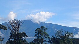
312:. With an elevation of 9,878 ft (3,011 m), it is the summit of the largest and highest of three overlapping
159:
108:
331:
270:
84:
17:
558:
Pérez del Val, Jaime 1996. Las Aves de Bioko, Guinea
Ecuatorial: Guia de Campo. Edilesa, Léon, Spain.
791:
713:
597:
906:
602:
572:
258:
76:
921:
1062:
1032:
841:
831:
415:
379:
101:
639:
505:
8:
1021:
901:
92:
961:
931:
851:
631:
434:
309:
246:
1057:
971:
966:
956:
821:
741:
1011:
981:
941:
936:
916:
736:
544:
483:
836:
816:
623:
1083:
986:
881:
871:
771:
751:
635:
592:
519:(1). Consejo Superior de Investigaciones Científicas “Real Jardín Botánico”: 46
504:
Fero, Maximiliano; Cabezas, Francisco; Aedo, Carlos; Velayos, Mauricio (2003).
387:
367:
359:
316:
263:
1077:
976:
911:
876:
776:
458:
441:
399:
383:
355:
130:
117:
414:. Multiple range restricted species occur on Pico Basilé, and one bird, the
926:
856:
781:
756:
731:
674:
444:
who was later governor of the island that was once
Fernando Po, now Bioko.
320:
437:
was the first
European to sight the island while seeking a path to India.
1047:
896:
866:
861:
846:
761:
721:
335:
375:
1037:
811:
801:
766:
746:
726:
371:
1042:
786:
390:. The other island volcanoes to the SW of Bioko Island are extinct.
339:
323:
can be seen to the northeast. Pico Basilé lies close to the city of
407:
363:
346:
53:
406:
as a whole are similar to that of the montane regions of adjacent
951:
891:
826:
806:
411:
1052:
946:
324:
313:
66:
577:(in French). Peuples Noirs Peuples Africains. pp. 27–92.
403:
305:
242:
421:, is wholly restricted to the volcano's higher elevations.
430:
Bantu-speaking groups since before the 7th century BC.
503:
506:"Check-List of the Piperaceae of Equatorial Guinea"
366:. This line includes other volcanic islands in the
567:
1075:
538:Network for Protected areas in Equatorial Guinea
690:
659:
291:
282:
220:
210:
173:
42:
33:
704:
697:
683:
666:
652:
478:
476:
474:
334:, created in April 2000 The boundaries of
1063:Saint Helena, Ascension, Tristan da Cunha
402:, the flora and fauna of Pico Basilé and
345:
319:which form the island. From the summit,
471:
362:that runs from the Atlantic Ocean into
14:
1076:
454:List of volcanoes in Equatorial Guinea
1094:Shield volcanoes of Equatorial Guinea
1043:French Southern & Antarctic Lands
678:
610:Bioko Biodiversity Protection Program
27:Tallest mountain of Equatorial Guinea
618:
513:Anales del Jardín Botánico de Madrid
497:
203:
166:
24:
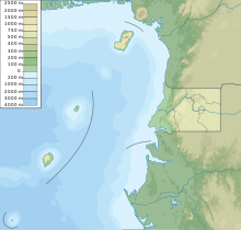
433:In 1472, the Portuguese navigator
393:
25:
1125:
1114:Equatorial Guinea geography stubs
1007:Sahrawi Arab Democratic Republic
777:Democratic Republic of the Congo
622:
202:
195:
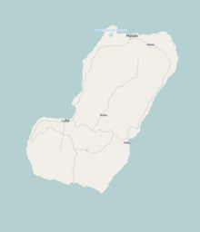
183:Location of Pico Basilé in Bioko
165:
158:
52:
1099:Volcanoes of the Atlantic Ocean
574:Connaître la Guinée équatoriale
1089:Mountains of Equatorial Guinea
561:
552:
531:
13:
1:
464:
358:, a major northeast-trending
308:, is the tallest mountain of
228:Show map of Equatorial Guinea
1109:Polygenetic shield volcanoes
1048:Heard & McDonald Islands
638:. You can help Knowledge by
304:), located on the island of
81:3,011 m (9,879 ft)
71:3,011 m (9,879 ft)
7:
1104:Highest points of countries
447:
354:Bioko was formed along the
10:
1130:
617:
585:
484:"Africa Ultra-Prominences"
424:
1020:
995:
712:
382:, along with the massive
332:Pico Basilé National Park
330:The peak forms a part of
283:
269:
257:
252:
238:
221:
211:
174:
151:
146:
107:
91:
75:
65:
60:
51:
41:
34:
32:
762:Central African Republic
706:Highest points of Africa
598:Global Volcanism Program
603:Smithsonian Institution
634:location article is a
351:
292:
43:
922:São Tomé and Príncipe
782:Republic of the Congo
349:
293:Pico de Santa Isabel
44:Pico de Santa Isabel
999:limited recognition
225:(Equatorial Guinea)
131:3.58333°N 8.76667°E
127: /
569:Max Liniger-Goumaz
543:2011-02-02 at the
352:
98:Country high point
61:Highest point
1071:
1070:
1026:other territories
797:Equatorial Guinea
647:
646:
632:Equatorial Guinea
418:Zoterops brunneus
310:Equatorial Guinea
279:
278:
247:Equatorial Guinea
186:Show map of Bioko
87:
16:(Redirected from
1121:
714:Sovereign states
699:
692:
685:
676:
675:
668:
661:
654:
626:
619:
606:
579:
578:
565:
559:
556:
550:
549:
535:
529:
528:
526:
524:
510:
501:
495:
494:
492:
491:
480:
317:shield volcanoes
295:
286:
229:
224:
214:
206:
205:
199:
187:
177:
169:
168:
162:
142:
141:
139:
138:
137:
136:3.58333; 8.76667
132:
128:
125:
124:
123:
120:
83:
56:
46:
37:
30:
29:
21:
1129:
1128:
1124:
1123:
1122:
1120:
1119:
1118:
1074:
1073:
1072:
1067:
1025:
1016:
998:
991:
708:
703:
673:
672:
615:
591:
588:
583:
582:
566:
562:
557:
553:
547:
545:Wayback Machine
536:
532:
522:
520:
508:
502:
498:
489:
487:
482:
481:
472:
467:
450:
427:
416:Bioko Speirops
396:
394:Flora and fauna
234:
233:
232:
231:
230:
227:
226:
218:
217:
216:
215:
207:
190:
189:
188:
185:
184:
181:
180:
179:
178:
170:
135:
133:
129:
126:
121:
118:
116:
114:
113:
100:
82:
47:, Clarence Peak
28:
23:
22:
15:
12:
11:
5:
1127:
1117:
1116:
1111:
1106:
1101:
1096:
1091:
1086:
1069:
1068:
1066:
1065:
1060:
1055:
1050:
1045:
1040:
1035:
1029:
1027:
1018:
1017:
1015:
1014:
1009:
1003:
1001:
993:
992:
990:
989:
984:
979:
974:
969:
964:
959:
954:
949:
944:
939:
934:
929:
924:
919:
914:
909:
904:
899:
894:
889:
884:
879:
874:
869:
864:
859:
854:
849:
844:
839:
834:
829:
824:
819:
814:
809:
804:
799:
794:
789:
784:
779:
774:
769:
764:
759:
754:
749:
744:
739:
734:
729:
724:
718:
716:
710:
709:
702:
701:
694:
687:
679:
671:
670:
663:
656:
648:
645:
644:
627:
613:
612:
607:
593:"Santa Isabel"
587:
584:
581:
580:
560:
551:
530:
496:
486:. Peaklist.org
469:
468:
466:
463:
462:
461:
456:
449:
446:
426:
423:
395:
392:
388:Mount Cameroon
368:Gulf of Guinea
360:geologic fault
277:
276:
273:
267:
266:
264:Shield volcano
261:
255:
254:
250:
249:
240:
236:
235:
219:
209:
208:
201:
200:
194:
193:
192:
191:
182:
172:
171:
164:
163:
157:
156:
155:
154:
153:
152:
149:
148:
144:
143:
111:
105:
104:
95:
89:
88:
79:
73:
72:
69:
63:
62:
58:
57:
49:
48:
39:
38:
26:
9:
6:
4:
3:
2:
1126:
1115:
1112:
1110:
1107:
1105:
1102:
1100:
1097:
1095:
1092:
1090:
1087:
1085:
1082:
1081:
1079:
1064:
1061:
1059:
1056:
1054:
1051:
1049:
1046:
1044:
1041:
1039:
1038:Bouvet Island
1036:
1034:
1031:
1030:
1028:
1023:
1019:
1013:
1010:
1008:
1005:
1004:
1002:
1000:
994:
988:
985:
983:
980:
978:
975:
973:
970:
968:
965:
963:
960:
958:
955:
953:
950:
948:
945:
943:
940:
938:
935:
933:
930:
928:
925:
923:
920:
918:
915:
913:
910:
908:
905:
903:
900:
898:
895:
893:
890:
888:
885:
883:
880:
878:
875:
873:
870:
868:
865:
863:
860:
858:
855:
853:
850:
848:
845:
843:
840:
838:
837:Guinea-Bissau
835:
833:
830:
828:
825:
823:
820:
818:
815:
813:
810:
808:
805:
803:
800:
798:
795:
793:
790:
788:
785:
783:
780:
778:
775:
773:
770:
768:
765:
763:
760:
758:
755:
753:
750:
748:
745:
743:
740:
738:
735:
733:
730:
728:
725:
723:
720:
719:
717:
715:
711:
707:
700:
695:
693:
688:
686:
681:
680:
677:
669:
664:
662:
657:
655:
650:
649:
643:
641:
637:
633:
628:
625:
621:
620:
616:
611:
608:
604:
600:
599:
594:
590:
589:
576:
575:
570:
564:
555:
546:
542:
539:
534:
518:
514:
507:
500:
485:
479:
477:
475:
470:
460:
459:Cameroon line
457:
455:
452:
451:
445:
443:
442:John Beecroft
438:
436:
431:
422:
420:
419:
413:
409:
405:
401:
400:Cameroon line
391:
389:
385:
384:stratovolcano
381:
377:
373:
369:
365:
361:
357:
356:Cameroon line
348:
344:
341:
337:
333:
328:
326:
322:
318:
315:
311:
307:
303:
302:
301:Clarence Peak
297:
296:
294:
287:
285:
274:
272:
271:Last eruption
268:
265:
262:
260:
259:Mountain type
256:
251:
248:
244:
241:
237:
223:
213:
198:
176:
161:
150:
145:
140:
112:
110:
106:
103:
99:
96:
94:
90:
86:
80:
78:
74:
70:
68:
64:
59:
55:
50:
45:
40:
36:
31:
19:
1022:Dependencies
947:South Africa
937:Sierra Leone
796:
742:Burkina Faso
640:expanding it
629:
614:
596:
573:
563:
554:
533:
521:. Retrieved
516:
512:
499:
488:. Retrieved
439:
435:Fernão do Pó
432:
428:
417:
398:Part of the
397:
353:
329:
321:Mt. Cameroon
300:
299:
290:
289:
281:
280:
997:States with
952:South Sudan
842:Ivory Coast
548:(in French)
350:Pico Basilé
336:Bioko Norte
284:Pico Basilé
222:Pico Basilé
212:Pico Basilé
175:Pico Basilé
134: /
109:Coordinates
85:Ranked 90th
35:Pico Basilé
18:Pico Basile
1078:Categories
1012:Somaliland
932:Seychelles
897:Mozambique
882:Mauritania
867:Madagascar
757:Cape Verde
490:2013-02-10
465:References
288:(formerly
77:Prominence
1033:Bir Tawil
887:Mauritius
807:Swaziland
523:15 August
147:Geography
122:8°46′00″E
119:3°35′00″N
67:Elevation
987:Zimbabwe
962:Tanzania
812:Ethiopia
787:Djibouti
752:Cameroon
737:Botswana
571:(1985).
541:Archived
448:See also
408:Cameroon
380:São Tomé
376:Príncipe
370:such as
364:Cameroon
314:basaltic
239:Location
1058:Réunion
1053:Mayotte
972:Tunisia
942:Somalia
927:Senegal
912:Nigeria
902:Namibia
892:Morocco
857:Liberia
852:Lesotho
802:Eritrea
772:Comoros
747:Burundi
722:Algeria
586:Sources
425:History
412:Nigeria
372:Annobón
253:Geology
93:Listing
982:Zambia
977:Uganda
917:Rwanda
872:Malawi
832:Guinea
822:Gambia
727:Angola
325:Malabo
1084:Bioko
957:Sudan
907:Niger
862:Libya
847:Kenya
827:Ghana
817:Gabon
792:Egypt
732:Benin
630:This
509:(PDF)
404:Bioko
306:Bioko
243:Bioko
102:Ultra
967:Togo
877:Mali
767:Chad
636:stub
525:2022
410:and
378:and
338:and
275:1923
1024:and
386:of
340:Sur
298:or
1080::
601:.
595:.
517:60
515:.
511:.
473:^
374:,
245:,
698:e
691:t
684:v
667:e
660:t
653:v
642:.
605:.
527:.
493:.
20:)
Text is available under the Creative Commons Attribution-ShareAlike License. Additional terms may apply.


