36:
308:
115:
122:
252:
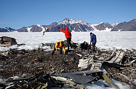
on a patrol mission crashed into the slope of the
Kronborg Glacier close to this range, killing all twelve men aboard. The crash site was finally discovered in 1966 when four geologists found it, but it was not until 2004 that the
35:
235:
382:
294:
282:
274:
161:
278:
114:
421:
436:
328:
239:
441:
154:
307:
311:
211:
333:
265:
The
Wiedemann Range is an up to 1,715 m (5,627 ft) high mountain massif made up of
249:
8:
446:
338:
286:
49:
370:
257:
recovered all the crew remains and memorialized the deceased at the crash site.
231:
199:
290:
270:
207:
430:
176:
163:
406:
45:
219:
215:
147:
230:
The range was visited in 1932 by a team of geologists belonging to
266:
254:
42:
269:. The southern end of the range rises close to the sea, in the
72:
246:
359:
Lands That Hold One
Spellbound: A Story of East Greenland
422:
The East
Greenland rifted volcanic margin - ResearchGate
297:to the east. The area of the range is uninhabited.
52:with the Wiedeman Range rising in the background.
428:
281:. It stretches northwards at the head of the
218:. Administratively this range is part of the
371:The fifty-year saga of the aircraft LA-9
306:
238:. It was named after German naturalist
121:
429:
329:List of mountain ranges of Greenland
289:to the west —beyond which rises the
375:
240:Christian Rudolph Wilhelm Wiedemann
13:
14:
458:
415:
400:
351:
236:Second East-Greenland Expedition
120:
113:
98:15 km (9.3 mi) E/W
34:
90:30 km (19 mi) N/S
364:
1:
344:
437:Mountain ranges of Greenland
260:
7:
322:
16:Mountain range in Greenland
10:
463:
334:List of Nunataks§Greenland
304:
225:
67:Wiedemann Range High Point
153:
143:
107:
102:
94:
86:
81:
71:
63:
58:
33:
26:
21:
77:115 m (377 ft)
314:map of Greenland sheet.
315:
312:Defense Mapping Agency
212:King Christian IX Land
203:
442:Nunataks of Greenland
310:
250:Lockheed P-2 Neptune
48:that crashed in the
357:Spencer Apollonio,
173: /
383:"Wiedemann Bjerge"
316:
295:Borggraven Glacier
59:Highest point
339:Blosseville Coast
320:
319:
192:
191:
177:68.650°N 28.483°W
155:Range coordinates
53:
454:
409:
404:
398:
397:
395:
393:
379:
373:
368:
362:
355:
303:
302:
287:Kronborg Glacier
204:Wiedemann Bjerge
188:
187:
185:
184:
183:
178:
174:
171:
170:
169:
166:
124:
123:
117:
50:Kronborg Glacier
40:
38:
28:Wiedemann Bjerge
19:
18:
462:
461:
457:
456:
455:
453:
452:
451:
427:
426:
418:
413:
412:
405:
401:
391:
389:
381:
380:
376:
369:
365:
356:
352:
347:
325:
300:
285:, bound by the
283:Wiedemann Fjord
275:Cape Stephensen
273:area, north of
263:
232:Ejnar Mikkelsen
228:
196:Wiedemann Range
182:68.650; -28.483
181:
179:
175:
172:
167:
164:
162:
160:
159:
139:
138:
137:
136:
135:
132:
131:
130:
129:
128:Wiedemann Range
125:
54:
22:Wiedemann Range
17:
12:
11:
5:
460:
450:
449:
444:
439:
425:
424:
417:
416:External links
414:
411:
410:
399:
374:
363:
349:
348:
346:
343:
342:
341:
336:
331:
324:
321:
318:
317:
291:Lilloise Range
277:and NW of the
271:Denmark Strait
262:
259:
227:
224:
222:Municipality.
208:mountain range
190:
189:
157:
151:
150:
145:
141:
140:
133:
127:
126:
119:
118:
112:
111:
110:
109:
108:
105:
104:
100:
99:
96:
92:
91:
88:
84:
83:
79:
78:
75:
69:
68:
65:
61:
60:
56:
55:
41:Wreckage of a
39:
31:
30:
24:
23:
15:
9:
6:
4:
3:
2:
459:
448:
445:
443:
440:
438:
435:
434:
432:
423:
420:
419:
408:
403:
388:
384:
378:
372:
367:
361:, 2008 p. 218
360:
354:
350:
340:
337:
335:
332:
330:
327:
326:
313:
309:
305:
301:
298:
296:
292:
288:
284:
280:
276:
272:
268:
258:
256:
251:
248:
243:
242:(1770–1840).
241:
237:
233:
223:
221:
217:
213:
209:
205:
201:
197:
186:
158:
156:
152:
149:
146:
142:
116:
106:
101:
97:
93:
89:
85:
80:
76:
74:
70:
66:
62:
57:
51:
47:
44:
37:
32:
29:
25:
20:
407:Google Earth
402:
390:. Retrieved
386:
377:
366:
358:
353:
299:
264:
244:
229:
195:
193:
46:P-2V Neptune
27:
279:Vedel Fjord
245:In 1962, a
180: /
447:Sermersooq
431:Categories
345:References
293:— and the
220:Sermersooq
214:, eastern
82:Dimensions
261:Geography
216:Greenland
148:Greenland
103:Geography
73:Elevation
323:See also
267:nunataks
134:Location
392:17 June
387:GeoHack
255:US Navy
226:History
206:) is a
168:28°29′W
165:68°39′N
144:Country
43:US Navy
200:Danish
87:Length
95:Width
394:2021
247:VP-5
194:The
64:Peak
234:'s
210:in
433::
385:.
202::
396:.
198:(
Text is available under the Creative Commons Attribution-ShareAlike License. Additional terms may apply.


