177:
471:
312:
377:
365:
169:
459:
498:
441:
114:
334:
296:
423:
402:
51:
238:. At the core of the district was Jackson Alley located next to the Government Printing Office Building, between G and H Streets and crossing North Capitol Street. It was a considered a virtual no-go area for the police and new recruits were often sent there for their training. The problem was more with the younger generation than the older folks. Gangs of young men known as "poodles" were the main cause of concern. But it was also a place to find work for its inhabitants. For a very long time, Jackson Alley was inhabited by "tinkers" or "tinners" because they were tinworkers.
521:
346:
289:. It was located on a block bounded by North Capitol Street NE and tracks (west); F Street NE (south); Delaware Avenue NE (east); and G Street NE (north). The McDowell and Sons plant, seen in the background of the ballpark photo behind right field, was listed in city directories as the corner of Massachusetts Avenue and North Capitol Street.
582:
The name "Swampoodle" has lost its negative connotation in the local community. As a result, a park at the intersection of 3rd Street NE and L Street NE, a block from the border of the old neighborhood, was named
Swampoodle Park in 2018 in honor of the historic neighborhood. The announcement was made
394:
in 1907. The plan involved the demolition of over 10 blocks of residential houses in the core of
Swampoodle. Over 100 houses were demolished to make way for the massive station and the rail yard. Squares 714 through 720 were razed. As part of the plan, the remainder of Tiber Creek was covered up in a
257:
As
Swampoodle was then on the edge of the city, many of the residents kept goats and cows, sometimes in livestock pens among the alleys dividing their modest houses. Until the 1880s, the north side of K Street was not built and the only things there were swamps, pasters, and the railway track. This
745:
Statement of Mr. Charles E. Smith, Private, Class 3, Metropolitan Police
Department of the District of Columbia. Report of hearings on H. R. 22322. Police and Firemen's Relief Fund. Subcommittee of Committee on the District of Columbia, House of Representatives, Washington, D. C, Friday, April 29,
573:
The
Capitol Hill Restoration Society (CHRS) has begun walking tours of four square blocks of the neighborhood that remains today between F and H Streets NE and 2nd and 4th Streets NE. CHRS is proposing to expand the Capitol Hill Historic District to include these blocks as part of their Beyond the
205:
remained undeveloped until the 1870s. The development of west of North
Capitol started developing in the 1850s with two major construction projects. In 1856, the first Government Printing Office building was built on the southeastern corner of Square 624 and the following year, H Street was grated
265:
In the 1870s, Tiber Creek was channeled underground along North
Capitol Street. From Florida Ave to M Street, the sewer was 20 feet in diameter and grew to 30 feet for the section below M Street. Due to the elevation of the ground level, many found themselves with one level under the level of the
129:
above
Judiciary Square was known as "English Hill" from E Street NE/NW on the South and 4th Street NW on the west all the way to Boundary Road. It was a rural area with almost no buildings and gravel sidewalks. This original settlement contracted to the area bordered by 4th Street NW, 1st NW, E
470:
395:
tunnel and the low-lying land in the area was filed in. The section of
Delaware Avenue between Florida Avenue (Previously known as Boundary Road) and Massachusetts Avenue was buried under the railway tracks with the exception of a small section between L Street and M Street NE.
583:
on
December 13, 2017 after an online survey was conducted asking the community to vote for one of three possible names, the other two options being Old City Corner and 3rd and L Park. A bill codifying the name was introduced on April 9, 2018, and sponsored by
481:
This major project physically divided the neighborhood and led to many of the 1,600 former residents moving to other parts of the city. Rezoning led to increased heavy industry in the area, making it unattractive for residential use.
311:
559:
with support from the Ireland-based Performance Corporation to help combat stereotypes about the Irish. It consists of colorful, disparate stories about life in the predominantly Irish neighborhood.
376:
333:
952:
364:
620:
between 4th, 5th, E and F Street NE where various events took place including picnics with dances which could lead to both fights and frolics. These picnics were apparently known as
295:
101:
on the border of Northwest and Northeast in the second half of 19th and early 20th century. This neighborhood is no longer known as Swampoodle and has been replaced in large part by
458:
855:
1001:
440:
41:
1869:
1864:
176:
1854:
1849:
1879:
1844:
141:
to the North, G Street NE to the South, 2nd Street NW to the West, and 2nd Street NE to the East. Through the center of it ran the principal branch of
944:
50:
994:
567:
633:
769:
1839:
234:
The neighborhood gained a reputation for being a lawless shantytown, where crime, prostitution, drunkenness were rife during and after the
17:
726:
584:
172:
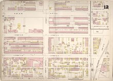
Sanborn Fire Insurance Map # 12 in 1888, showing the notorious Jackson Alley next to the Government Printing Office Building (square 624)
1800:
1874:
987:
168:
148:
The origin of the name "Swampoodle" is believed to come from a newspaper reporter covering the ground-breaking of the Roman Catholic
401:
1780:
422:
505:
210:
149:
1859:
1604:
1240:
784:
1755:
1669:
1124:
1038:
1033:
548:, it is under the Government Printing Office Building. On the east side of North Capitol, it is now known as G Place NE.
190:
Swampoodle developed during the second half of the 19th century, providing a place of refuge for emigrants following the
497:
1664:
1250:
1068:
231:
population had left the neighborhood. They were replaced by Greeks and Italians immigrants and some African-Americans.
152:
in 1857, who referred to the land at the site at the intersection of North Capitol and I Street as containing numerous
125:
A geographic approximation can only be evaluated as it was never clearly defined. Originally, the northeastern part of
1523:
1058:
1010:
1699:
1462:
1452:
1255:
1245:
529:
318:
278:
1579:
1538:
1427:
1397:
1280:
1200:
1129:
1078:
1735:
1629:
1432:
1331:
1311:
1185:
113:
1654:
1619:
1472:
1341:
1301:
1119:
540:, a legacy of its original settlers. It is surrounded by some of the original dwellings, particularly in the
1760:
1649:
1644:
1634:
1574:
1487:
1417:
1407:
1402:
1392:
1336:
1321:
1265:
1099:
1063:
843:
533:
905:
1785:
1750:
1745:
1730:
1639:
1477:
1422:
1351:
1154:
1104:
1073:
537:
509:
221:
138:
345:
1775:
1704:
1674:
1559:
1447:
1437:
1205:
1175:
880:
643:
613:
130:
Street NE/NW, H Street NE/NW. "Swampoodle" was the name of a smaller settlement along H Street between
684:
The Sunday Star, July 4, 1909, Part 4, page 3 - When Old "Swampoodle" was in the height of its "Glory"
544:
section to the east of Delaware Avenue. Jackson Alley is no longer known as such. On the west side of
1376:
1371:
1170:
1149:
766:
513:
407:
391:
383:
259:
1220:
1144:
856:"Restoration Society Hears Recommendations for Major Expansion of Capitol Hill Historic District"
616:(also known as Mount Vernon Lager Beer Brewery and Pleasure Garden). It was a gathering place on
563:
191:
1518:
1225:
302:
820:
1533:
1346:
1275:
1235:
545:
501:
202:
131:
591:. Resolution R22-0478 effective from April 10, 2018 passed on April 20, 2018 by 12 votes.
8:
1457:
1134:
253:. But Swampoodle was a thriving community, whose Irish construction workers helped build
706:
Department of Transportation Headquarters: Environmental Impact Statement, GSA June 2000
390:
The demise of Swampoodle as a community and neighborhood began with the construction of
1684:
1326:
1210:
727:"Two Plumbers and a Plasterer Go Looking for Trouble and Find It (1895) | Ghosts of DC"
339:
Houses on 1st Street NE which were razed to make way for the Tiber Creek tunnel in 1904
274:
235:
1584:
1180:
973:
Looking Backward by Capt. J. Walter Mitchell - The Washington Herald - April 13, 1919
608:
979:
756:
Wallace, Arminta (3 June 2011). "If we can make it there.". Irish Times. p. 12.
520:
1740:
1694:
1609:
1589:
1513:
1316:
1014:
592:
286:
282:
254:
126:
118:
98:
78:
56:
945:"NoMa Is Getting Its First Public Park. There Will Be A Puppy Parade To Celebrate"
821:"Capitol Hill Restoration Society » Walking Tour of Swampoodle June 29, 2013"
1770:
1614:
1564:
1412:
1306:
930:
773:
214:
668:
Pictures of the city of Washington in the past, Samuel C. Busey, MD, LL.D., 1898
1679:
1482:
1270:
1230:
1190:
1043:
588:
541:
228:
528:
Today, the area is occupied primarily by office complexes, rail yards serving
1833:
1815:
1802:
1569:
1503:
1467:
1366:
1356:
1296:
1109:
1053:
68:
612:
on April 13, 1919, Capt. J. Walter Mitchell talks about the 1860s and 1870s
1659:
1508:
1139:
1114:
1048:
1028:
617:
486:
217:
1765:
1689:
1624:
1599:
1215:
1195:
476:
Aerial view northeast of Washington Union Station, where Swampoodle stood
142:
844:
http://chrs.org/wp-content/uploads/2013/06/WTswampoodleHandout1307BP.pdf
566:" which stands for "North of Massachusetts Avenue." It is served by the
277:, a stadium with a capacity of approximately 6,000, was the home of the
1725:
1361:
1260:
1720:
556:
250:
1594:
1442:
1094:
881:"Capitol Hill Restoration Society » Beyond the Boundaries Map"
562:
Since 2007, the neighborhood has been included in the rebranded "
246:
242:
195:
180:
Detail showing the paved areas in Swampoodle around Tiber Creek,
624:
probably due to the rough nature of the events and the fights.
157:
134:
and 1st NE but extended to take a big part of "English Hill".
153:
213:
is built at 19 I Street NE on square 622. It catered to the
1528:
796:
638:
160:
that often occurred when Tiber Creek overflowed its banks.
102:
206:
and graveled between New Jersey Avenue and North Capitol.
933:
It was published in the DC Register Vol 65 on page 4314.
702:
700:
698:
696:
694:
692:
690:
489:
period, even the name Swampoodle was largely forgotten.
258:
almost rural lifestyle continued until about 1907, when
145:
running between North Capitol Street and 1st Street NE.
551:
The neighborhood got some press after a play about it,
785:
Swampoodle: The neighborhood behind the play | TBD.com
664:
662:
660:
1009:
687:
485:
The identity of Swampoodle died away and by the post-
241:
The area was known for overcrowding and outbreaks of
749:
657:
555:by Tom Swift, debuted in 2011. It was produced by
446:The train concourse at Washington Union Station,
1831:
715:The Washington Herald, November 24, 1918, page 3
680:
678:
676:
674:
464:Tracks and platforms at Washington Union Station
931:http://lims.dccouncil.us/Legislation/PR22-0826
634:History of Irish Americans in Washington, D.C.
598:The park officially opened November 17, 2018.
1870:Neighborhoods in Northeast (Washington, D.C.)
995:
906:"Meet NoMa's first new park: Swampoodle Park"
671:
1865:Italian-American culture in Washington, D.C.
929:Washington D.C. Council Resolution 220826 -
370:Map showing the impact of the railway tracks
601:
1855:Irish-American culture in Washington, D.C.
1850:Greek-American culture in Washington, D.C.
1002:
988:
724:
1880:Working-class culture in Washington, D.C.
1845:Former neighborhoods in the United States
568:NoMa – Gallaudet University Metro station
305:taken on June 27, 1861 showing Swampoodle
614:Humphrey and Juenemann's Pleasure Garden
519:
516:several blocks in the opposite direction
496:
356:
175:
167:
112:
903:
755:
227:By the early 20th century, most of the
14:
1832:
955:from the original on November 18, 2018
983:
942:
904:Russell, Edward (December 13, 2017).
269:
137:Later on, its borders contracted to
1840:Ethnic enclaves in Washington, D.C.
943:Sadon, Rachel (November 16, 2018).
593:Council Member Elissa Silverman (I)
24:
577:
224:moved to the same square in 1871.
59:with Swampoodle highlighted in red
25:
1891:
1875:Near Northeast (Washington, D.C.)
1074:U Street Corridor (Cardozo/Shaw)
585:Council Member Charles Allen (D)
469:
457:
439:
421:
400:
375:
363:
344:
332:
310:
294:
49:
42:Neighborhood of Washington, D.C.
967:
936:
923:
897:
873:
848:
837:
813:
789:
606:In an article published in the
778:
760:
739:
718:
709:
13:
1:
650:
447:
429:
411:
322:
181:
1860:Irish-American neighborhoods
534:Government Publishing Office
317:Swampoodle Grounds with the
211:St. Aloysius Catholic Church
108:
18:Swampoodle, Washington, D.C.
7:
627:
589:Chairman Phil Mendelson (D)
538:Gonzaga College High School
510:Gonzaga College High School
222:Gonzaga College High School
10:
1896:
1473:Stronghold-Metropolis View
910:Greater Greater Washington
644:Washington Brewery Company
492:
428:Washington Union Station,
382:Map showing the impact of
220:population of Swampoodle.
163:
27:Place in the United States
1713:
1552:
1496:
1385:
1289:
1163:
1087:
1021:
725:ghostsofdc (2012-01-12).
351:St. Aloysius Church today
84:
74:
64:
48:
39:
32:
1372:Sixteenth Street Heights
1171:American University Park
1150:Southwest Federal Center
602:References to Swampoodle
514:Washington Union Station
408:Washington Union Station
384:Washington Union Station
260:Washington Union Station
1816:38.900194°N 77.008194°W
574:Boundaries initiative.
198:between 1845 and 1849.
192:Great Famine of Ireland
525:
517:
187:
173:
122:
97:was a neighborhood in
1821:38.900194; -77.008194
1519:Mount Vernon Triangle
1226:Massachusetts Heights
523:
500:
357:The end of Swampoodle
303:United States Capitol
179:
171:
117:Map of Swampoodle in
116:
1781:Washington Highlands
1534:Southwest Waterfront
1347:North Portal Estates
1276:Woodland Normanstone
1236:North Cleveland Park
546:North Capitol Street
524:Swampoodle Park sign
502:North Capitol Street
319:Washington Statesmen
279:Washington Statesmen
203:North Capitol Street
132:North Capitol Street
1812: /
1458:North Michigan Park
1135:Mount Vernon Square
860:CAPITOL HILL CORNER
570:and Union Station.
506:St. Aloysius Church
281:baseball team from
150:St. Aloysius Church
1685:Northeast Boundary
1605:East River Heights
1327:Fort Stevens Ridge
1241:Observatory Circle
1211:Friendship Heights
772:2013-04-15 at the
526:
518:
275:Swampoodle Grounds
270:Swampoodle Grounds
188:
174:
123:
1794:
1793:
1585:Central Northeast
1181:Cathedral Heights
1125:Sheridan-Kalorama
1039:Kalorama Triangle
609:Washington Herald
201:The area east of
92:
91:
16:(Redirected from
1887:
1827:
1826:
1824:
1823:
1822:
1817:
1813:
1810:
1809:
1808:
1805:
1756:Garfield Heights
1741:Congress Heights
1695:Randle Highlands
1670:Marshall Heights
1610:Eastland Gardens
1590:Civic Betterment
1514:Judiciary Square
1317:Colonial Village
1034:Columbia Heights
1015:Washington, D.C.
1004:
997:
990:
981:
980:
974:
971:
965:
964:
962:
960:
940:
934:
927:
921:
920:
918:
916:
901:
895:
894:
892:
891:
877:
871:
870:
868:
867:
852:
846:
841:
835:
834:
832:
831:
817:
811:
810:
808:
807:
793:
787:
782:
776:
764:
758:
757:
753:
747:
743:
737:
736:
734:
733:
722:
716:
713:
707:
704:
685:
682:
669:
666:
622:Swampoodle Walks
473:
461:
452:
449:
443:
434:
431:
425:
416:
413:
404:
379:
367:
348:
336:
327:
326: 1886-1889
324:
314:
301:View north from
298:
255:Washington, D.C.
194:that devastated
186:
183:
127:Washington, D.C.
119:Washington, D.C.
99:Washington, D.C.
79:Washington, D.C.
57:Washington, D.C.
53:
30:
29:
21:
1895:
1894:
1890:
1889:
1888:
1886:
1885:
1884:
1830:
1829:
1820:
1818:
1814:
1811:
1806:
1803:
1801:
1799:
1798:
1797:
1795:
1790:
1771:Shipley Terrace
1709:
1665:Lincoln Heights
1615:Fairfax Village
1565:Benning Heights
1548:
1492:
1413:Carver Langston
1381:
1307:Brightwood Park
1285:
1251:Potomac Heights
1159:
1083:
1069:Pleasant Plains
1017:
1008:
978:
977:
972:
968:
958:
956:
941:
937:
928:
924:
914:
912:
902:
898:
889:
887:
879:
878:
874:
865:
863:
854:
853:
849:
842:
838:
829:
827:
819:
818:
814:
805:
803:
801:www.nomabid.org
795:
794:
790:
783:
779:
774:Wayback Machine
765:
761:
754:
750:
744:
740:
731:
729:
723:
719:
714:
710:
705:
688:
683:
672:
667:
658:
653:
646:on Capitol Hill
630:
604:
580:
578:Swampoodle Park
495:
477:
474:
465:
462:
453:
450:
444:
435:
432:
426:
417:
414:
405:
386:
380:
371:
368:
359:
352:
349:
340:
337:
328:
325:
321:baseball team,
315:
306:
299:
272:
184:
166:
111:
60:
44:
35:
28:
23:
22:
15:
12:
11:
5:
1893:
1883:
1882:
1877:
1872:
1867:
1862:
1857:
1852:
1847:
1842:
1792:
1791:
1789:
1788:
1783:
1778:
1773:
1768:
1763:
1758:
1753:
1748:
1743:
1738:
1733:
1728:
1723:
1717:
1715:
1711:
1710:
1708:
1707:
1702:
1697:
1692:
1687:
1682:
1680:Naylor Gardens
1677:
1672:
1667:
1662:
1657:
1652:
1647:
1642:
1637:
1632:
1627:
1622:
1617:
1612:
1607:
1602:
1597:
1592:
1587:
1582:
1577:
1572:
1567:
1562:
1556:
1554:
1550:
1549:
1547:
1546:
1541:
1536:
1531:
1526:
1524:Near Northeast
1521:
1516:
1511:
1506:
1500:
1498:
1494:
1493:
1491:
1490:
1485:
1483:Truxton Circle
1480:
1475:
1470:
1465:
1460:
1455:
1450:
1445:
1440:
1435:
1430:
1425:
1420:
1415:
1410:
1405:
1400:
1395:
1389:
1387:
1383:
1382:
1380:
1379:
1374:
1369:
1364:
1359:
1354:
1349:
1344:
1339:
1334:
1329:
1324:
1319:
1314:
1309:
1304:
1299:
1293:
1291:
1287:
1286:
1284:
1283:
1278:
1273:
1271:Wesley Heights
1268:
1263:
1258:
1253:
1248:
1243:
1238:
1233:
1231:McLean Gardens
1228:
1223:
1218:
1213:
1208:
1203:
1198:
1193:
1191:Cleveland Park
1188:
1183:
1178:
1173:
1167:
1165:
1161:
1160:
1158:
1157:
1152:
1147:
1142:
1137:
1132:
1127:
1122:
1117:
1112:
1107:
1102:
1097:
1091:
1089:
1085:
1084:
1082:
1081:
1076:
1071:
1066:
1061:
1059:Mount Pleasant
1056:
1051:
1046:
1044:Lanier Heights
1041:
1036:
1031:
1025:
1023:
1019:
1018:
1007:
1006:
999:
992:
984:
976:
975:
966:
935:
922:
896:
872:
847:
836:
812:
788:
777:
759:
748:
738:
717:
708:
686:
670:
655:
654:
652:
649:
648:
647:
641:
636:
629:
626:
603:
600:
595:did not vote.
579:
576:
542:Near Northeast
494:
491:
479:
478:
475:
468:
466:
463:
456:
454:
445:
438:
436:
427:
420:
418:
406:
399:
388:
387:
381:
374:
372:
369:
362:
358:
355:
354:
353:
350:
343:
341:
338:
331:
329:
316:
309:
307:
300:
293:
271:
268:
229:Irish American
215:Roman Catholic
165:
162:
110:
107:
90:
89:
86:
82:
81:
76:
72:
71:
66:
62:
61:
54:
46:
45:
40:
37:
36:
33:
26:
9:
6:
4:
3:
2:
1892:
1881:
1878:
1876:
1873:
1871:
1868:
1866:
1863:
1861:
1858:
1856:
1853:
1851:
1848:
1846:
1843:
1841:
1838:
1837:
1835:
1828:
1825:
1787:
1784:
1782:
1779:
1777:
1774:
1772:
1769:
1767:
1764:
1762:
1759:
1757:
1754:
1752:
1749:
1747:
1744:
1742:
1739:
1737:
1734:
1732:
1729:
1727:
1724:
1722:
1719:
1718:
1716:
1712:
1706:
1703:
1701:
1700:River Terrace
1698:
1696:
1693:
1691:
1688:
1686:
1683:
1681:
1678:
1676:
1673:
1671:
1668:
1666:
1663:
1661:
1658:
1656:
1653:
1651:
1648:
1646:
1643:
1641:
1638:
1636:
1633:
1631:
1628:
1626:
1623:
1621:
1618:
1616:
1613:
1611:
1608:
1606:
1603:
1601:
1598:
1596:
1593:
1591:
1588:
1586:
1583:
1581:
1578:
1576:
1573:
1571:
1570:Benning Ridge
1568:
1566:
1563:
1561:
1558:
1557:
1555:
1551:
1545:
1542:
1540:
1537:
1535:
1532:
1530:
1527:
1525:
1522:
1520:
1517:
1515:
1512:
1510:
1507:
1505:
1504:Barney Circle
1502:
1501:
1499:
1495:
1489:
1486:
1484:
1481:
1479:
1476:
1474:
1471:
1469:
1468:Queens Chapel
1466:
1464:
1463:Pleasant Hill
1461:
1459:
1456:
1454:
1453:Michigan Park
1451:
1449:
1446:
1444:
1441:
1439:
1436:
1434:
1431:
1429:
1426:
1424:
1421:
1419:
1416:
1414:
1411:
1409:
1406:
1404:
1401:
1399:
1396:
1394:
1391:
1390:
1388:
1384:
1378:
1375:
1373:
1370:
1368:
1367:Shepherd Park
1365:
1363:
1360:
1358:
1357:Queens Chapel
1355:
1353:
1350:
1348:
1345:
1343:
1340:
1338:
1335:
1333:
1330:
1328:
1325:
1323:
1320:
1318:
1315:
1313:
1310:
1308:
1305:
1303:
1300:
1298:
1297:Barnaby Woods
1295:
1294:
1292:
1288:
1282:
1279:
1277:
1274:
1272:
1269:
1267:
1264:
1262:
1259:
1257:
1256:Spring Valley
1254:
1252:
1249:
1247:
1246:The Palisades
1244:
1242:
1239:
1237:
1234:
1232:
1229:
1227:
1224:
1222:
1219:
1217:
1214:
1212:
1209:
1207:
1204:
1202:
1199:
1197:
1194:
1192:
1189:
1187:
1184:
1182:
1179:
1177:
1174:
1172:
1169:
1168:
1166:
1162:
1156:
1153:
1151:
1148:
1146:
1143:
1141:
1138:
1136:
1133:
1131:
1128:
1126:
1123:
1121:
1118:
1116:
1113:
1111:
1110:Dupont Circle
1108:
1106:
1103:
1101:
1098:
1096:
1093:
1092:
1090:
1086:
1080:
1077:
1075:
1072:
1070:
1067:
1065:
1062:
1060:
1057:
1055:
1054:Meridian Hill
1052:
1050:
1047:
1045:
1042:
1040:
1037:
1035:
1032:
1030:
1027:
1026:
1024:
1020:
1016:
1012:
1011:Neighborhoods
1005:
1000:
998:
993:
991:
986:
985:
982:
970:
954:
950:
946:
939:
932:
926:
911:
907:
900:
886:
882:
876:
861:
857:
851:
845:
840:
826:
822:
816:
802:
798:
792:
786:
781:
775:
771:
768:
763:
752:
742:
728:
721:
712:
703:
701:
699:
697:
695:
693:
691:
681:
679:
677:
675:
665:
663:
661:
656:
645:
642:
640:
637:
635:
632:
631:
625:
623:
619:
615:
611:
610:
599:
596:
594:
590:
586:
575:
571:
569:
565:
560:
558:
554:
549:
547:
543:
539:
535:
531:
530:Union Station
522:
515:
512:visible, and
511:
507:
504:in 2014 with
503:
499:
490:
488:
483:
472:
467:
460:
455:
442:
437:
424:
419:
409:
403:
398:
397:
396:
393:
392:Union Station
385:
378:
373:
366:
361:
360:
347:
342:
335:
330:
320:
313:
308:
304:
297:
292:
291:
290:
288:
284:
280:
276:
267:
263:
261:
256:
252:
248:
244:
239:
237:
232:
230:
225:
223:
219:
216:
212:
207:
204:
199:
197:
193:
178:
170:
161:
159:
155:
151:
146:
144:
140:
135:
133:
128:
120:
115:
106:
104:
100:
96:
87:
83:
80:
77:
73:
70:
69:United States
67:
63:
58:
52:
47:
43:
38:
31:
19:
1796:
1660:Kingman Park
1630:Fort Stanton
1580:Capitol View
1543:
1539:Sursum Corda
1509:Capitol Hill
1428:Fort Lincoln
1398:Bloomingdale
1281:Woodley Park
1201:Forest Hills
1140:Penn Quarter
1130:Logan Circle
1115:Foggy Bottom
1079:Woodley Park
1049:LeDroit Park
1029:Adams Morgan
969:
957:. Retrieved
948:
938:
925:
913:. Retrieved
909:
899:
888:. Retrieved
884:
875:
864:. Retrieved
862:. 2011-02-16
859:
850:
839:
828:. Retrieved
824:
815:
804:. Retrieved
800:
791:
780:
767:DCist review
762:
751:
741:
730:. Retrieved
720:
711:
621:
618:Capitol Hill
607:
605:
597:
581:
572:
561:
552:
550:
527:
487:World War II
484:
480:
389:
273:
264:
240:
233:
226:
208:
200:
189:
147:
136:
124:
94:
93:
1819: /
1807:77°0′29.5″W
1804:38°54′0.7″N
1766:Park Naylor
1736:Buena Vista
1690:Penn Branch
1625:Fort Dupont
1600:Dupont Park
1433:Fort Totten
1332:Fort Totten
1312:Chevy Chase
1216:Glover Park
1196:Colony Hill
1186:Chevy Chase
451: 1920
433: 1920
415: 1910
262:was built.
185: 1873
143:Tiber Creek
139:K Street NE
1834:Categories
1726:Barry Farm
1655:Kenilworth
1620:Fort Davis
1544:Swampoodle
1362:Riggs Park
1342:Manor Park
1302:Brightwood
1261:Tenleytown
1120:Georgetown
959:5 November
915:5 November
890:2021-12-30
866:2021-12-30
830:2021-12-30
806:2021-12-30
797:"NoMa BID"
732:2019-12-31
651:References
553:Swampoodle
95:Swampoodle
34:Swampoodle
1761:Navy Yard
1721:Anacostia
1650:Hillcrest
1645:Hillbrook
1635:Good Hope
1575:Burrville
1488:Woodridge
1418:Eckington
1408:Brookland
1403:Brentwood
1393:Arboretum
1337:Hawthorne
1322:Crestwood
1266:Wakefield
1100:Chinatown
1064:Park View
557:Solas Nua
251:dysentery
236:Civil War
209:In 1859,
109:Geography
1786:Woodland
1751:Fairlawn
1746:Douglass
1731:Bellevue
1640:Greenway
1595:Deanwood
1478:Trinidad
1443:Ivy City
1423:Edgewood
1352:Petworth
1155:West End
1105:Downtown
1095:Burleith
953:Archived
885:chrs.org
825:chrs.org
770:Archived
628:See also
266:street.
75:District
1776:Skyland
1705:Twining
1675:Mayfair
1560:Benning
1448:Langdon
1438:Gateway
1206:Foxhall
1176:Berkley
493:Present
247:typhoid
243:malaria
196:Ireland
164:History
158:puddles
121:in 1893
65:Country
55:Map of
1714:Ward 8
1553:Ward 7
1497:Ward 6
1386:Ward 5
1377:Takoma
1290:Ward 4
1164:Ward 3
1088:Ward 2
1022:Ward 1
532:, the
249:, and
154:swamps
88:Ward 6
949:dcist
746:1910.
218:Irish
1529:NoMa
1221:Kent
1145:Shaw
961:2022
917:2022
639:NoMa
587:and
564:NoMa
536:and
508:and
287:1889
283:1886
156:and
103:NoMa
85:Ward
1013:in
285:to
1836::
951:.
947:.
908:.
883:.
858:.
823:.
799:.
689:^
673:^
659:^
448:c.
430:c.
412:c.
410:,
323:c.
245:,
182:c.
105:.
1003:e
996:t
989:v
963:.
919:.
893:.
869:.
833:.
809:.
735:.
20:)
Text is available under the Creative Commons Attribution-ShareAlike License. Additional terms may apply.


.png)