379:
530:
367:
59:
76:
101:
1193:
343:
355:
319:
391:
331:
1204:
108:
83:
278:, which opened up real estate, and two disastrous fires in 1886 and 1896, which destroyed many of the commercial buildings on Water Street. A hydroelectric power canal was constructed in the early 20th century, and the commercial district expanded even more rapidly in response. Construction slowed down in the 1910s and 20s, and even more in the 1930s due to the
270:
increased, Sault Ste. Marie grew, due to its strategic location on the portage route around the rapids. This was accelerated by the 1840s copper boom, and more so by the construction of the first
American lock in 1855. By this time, the early commercial center of the city along Water Street was
294:
The Sault Ste. Marie
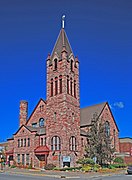
Commercial Historic District includes the historic business district in the center of the city, and the nearby houses of early residents and business leaders. This district contains 146 buildings, of which 104 contribute to the historical character of the neighborhood. The
306:
The commercial blocks of the district are located along the five blocks of Ashmun Street south to the Power Canal, and the adjacent blocks east and west along
Portage Avenue. Although the district is predominantly commercial, it also includes with several government buildings and religious
302:
and 1968, although most date from the late nineteenth century. Architectural styles include
Italianate, Late Victorian, Richardsonian Romanesque, and Commercial Brick commercial buildings, Neoclassical public buildings, and vernacular and Colonial Revival houses.
485:
1082:
478:
1233:
286:, but the downtown declined in the 1950s and 1960s as urban sprawl drew people away from the commercial core of the city. However, more recently, the Downtown Development Authority has reinvigorated the downtown area.
1243:
1177:
1113:
471:
1097:
1087:
1238:
701:
274:
The city boomed in the 1880 and 1890s, with a number of buildings constructed. The move of the commercial center from Water Street to Ashmun was accelerated by two things: the 1892 relocation of
1172:
1118:
759:
1139:
1041:
1072:
1006:
971:
556:
231:
1228:
1046:
951:
911:
736:
141:
128:
Ashmun St. between Water and
Easterday Sts., Portage Ave. between Brady and Ferris Sts., and Ashmun St. cross street blocks of Ridge, Maple, Arlington, Ann, and Spruce Sts.,
1011:
1001:
996:
976:
656:
586:
1092:
926:
841:
606:
961:
956:
831:
1051:
1016:
921:
896:
1036:
986:
966:
941:
931:
916:
906:
891:
871:
846:
836:
826:
1056:
1031:
936:
876:
856:
851:
821:
811:
991:
946:
886:
861:
816:
1123:
1021:
901:
866:
100:
1077:
1026:
981:
881:
789:
774:
538:
75:
729:
805:
611:
705:
1207:
722:
596:
1197:
546:
235:
366:
591:
566:
378:
769:
581:
506:
307:
properties, as well as historic residences along Water and
Bingham streets, most of which have been converted to commercial use.
223:
45:
641:
263:
745:
576:
529:
494:
219:
36:
250:
Sault Ste. Marie was first settled by
European immigrants in 1668. It was controlled by Britain or France until after the
1160:
626:
463:
616:
354:
448:
271:
expanded along nearby Ashmun Street. The twelve commercial enterprises in the city in 1856 grew to 70 by 1879.
342:
418:
1165:
1144:
679:
561:
318:
227:
215:
129:
621:
498:
450:
National
Register of Historic Places Registration Form: Sault Ste. Marie Historic Commercial District
646:
390:
180:
330:
779:
784:
764:
669:
58:
714:
651:
631:
8:
194:
571:
493:
1178:
University and college buildings listed on the
National Register of Historic Places
279:
267:
661:
1222:
259:
156:
143:
1234:
Commercial buildings on the
National Register of Historic Places in Michigan
283:
1244:
Historic districts on the National Register of Historic Places in Michigan
702:
National Register of Historic Places listings in Chippewa County, Michigan
601:
551:
295:
buildings are mostly two stories in height, and were constructed between
251:
239:
636:
514:
275:
176:
1173:
List of jails and prisons on the National Register of Historic Places
687:
107:
82:
1239:
National Register of Historic Places in Chippewa County, Michigan
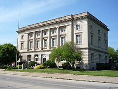
419:"Weekly List of Actions Taken on Properties: 10/19/20 - 10/22/20"
255:
242:, all of which are listed separately on the National Register.
744:
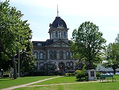
214:
is a primarily commercial historic district located in
183:, and Commercial Brick, Neoclassical, Colonial Revival
1229:
Buildings and structures in Chippewa County, Michigan
775:
History of the National Register of Historic Places
806:List of U.S. National Historic Landmarks by state
1220:
1198:National Register of Historic Places portal
706:List of National Historic Landmarks in Michigan
446:
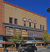
730:
520:Sault Ste. Marie Historic Commercial District
479:
456:, Michigan State Historic Preservation Office
212:Sault Ste. Marie Historic Commercial District
29:Sault Ste. Marie Historic Commercial District
597:Garfield School (Sault Ste. Marie, Michigan)
737:
723:
486:
472:
57:
746:U.S. National Register of Historic Places
567:Church of Our Saviour, Friend of Children
421:. National Park Service. October 23, 2020
37:U.S. National Register of Historic Places
1221:
718:
467:
442:
440:
438:
436:
413:
411:
495:National Register of Historic Places
220:National Register of Historic Places
222:in 2020. The district includes the
13:
1161:National Historic Preservation Act
642:Parker Road–Charlotte River Bridge
557:Central Methodist Episcopal Church
433:
408:
372:Central Methodist Episcopal Church
232:Central Methodist Episcopal Church
14:
1255:
447:William Rutter (March 20, 2019),
1203:
1202:
1191:
617:Kinross Township Hall and School
587:First United Presbyterian Church
528:
389:
377:
365:
353:
341:
329:
317:
106:
99:
81:
74:
607:Holy Name of Mary Pro-Cathedral
282:. Construction picked up after
1114:Federated States of Micronesia
760:Architectural style categories
289:
266:. As settlement of Michigan's
189:
1:
657:Saint James' Episcopal Church
627:M-28–Tahquamenon River Bridge
401:
296:
115:Show map of the United States
18:United States historic place
7:
10:
1260:
1166:Historic Preservation Fund
1145:American Legation, Morocco
680:National Historic Landmark
562:Chippewa County Courthouse
360:Chippewa County Courthouse
310:
254:, when the border between
245:
228:Chippewa County Courthouse
216:Sault Ste. Marie, Michigan
1186:
1153:
1132:
1107:Lists by associated state
1106:
1065:
798:
752:
696:
678:
622:Lipsett Hardware Building
537:
526:
505:
499:Chippewa County, Michigan
200:
188:NRHP reference
187:
172:
135:
124:
68:
56:
52:
43:
34:
27:
23:
1088:Northern Mariana Islands
647:Philetus S. Church House
218:. It was listed on the
181:Richardsonian Romanesque
173:Architectural style
1083:Minor Outlying Islands
1066:Lists by insular areas
780:Keeper of the Register
46:U.S. Historic district
785:National Park Service
765:Contributing property
688:St. Marys Falls Canal
670:Whitefish Point Light
157:46.50028°N 84.34583°W
1140:District of Columbia
652:Point Iroquois Light
632:Naomikong Point Site
348:Old Federal Building
224:Old Federal Building
90:Show map of Michigan
612:John Johnston House
539:Historic properties
162:46.50028; -84.34583
153: /
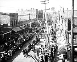
63:Ashmun Street, 1905
507:Historic districts
179:, Late Victorian,
1216:
1215:
770:Historic district
712:
711:
572:DeTour Reef Light
262:was fixed at the
208:
207:
1251:
1206:
1205:
1196:
1195:
1194:
1119:Marshall Islands
739:
732:
725:
716:
715:
582:Federal Building
532:
488:
481:
474:
465:
464:
458:
457:
455:
444:
431:
430:
428:
426:
415:
393:
381:
369:
357:
345:
333:
321:
301:
298:
280:Great Depression
204:October 19, 2020
191:
168:
167:
165:
164:
163:
158:
154:
151:
150:
149:
146:
130:Sault Ste. Marie
116:
110:
109:
103:
91:
85:
84:
78:
61:
21:
20:
1259:
1258:
1254:
1253:
1252:
1250:
1249:
1248:
1219:
1218:
1217:
1212:
1192:
1190:
1182:
1149:
1128:
1102:
1061:
794:
748:
743:
713:
708:
692:
674:
533:
524:
501:
492:
462:
461:
453:
445:
434:
424:
422:
417:
416:
409:
404:
397:
394:
385:
382:
373:
370:
361:
358:
349:
346:
337:
334:
325:
322:
313:
299:
292:
268:Upper Peninsula
264:St. Marys River
248:
161:
159:
155:
152:
147:
144:
142:
140:
139:
120:
119:
118:
117:
114:
113:
112:
111:
94:
93:
92:
89:
88:
87:
86:
64:
48:
39:
30:
19:
12:
11:
5:
1257:
1247:
1246:
1241:
1236:
1231:
1214:
1213:
1211:
1210:
1200:
1187:
1184:
1183:
1181:
1180:
1175:
1170:
1169:
1168:
1157:
1155:
1151:
1150:
1148:
1147:
1142:
1136:
1134:
1130:
1129:
1127:
1126:
1121:
1116:
1110:
1108:
1104:
1103:
1101:
1100:
1098:Virgin Islands
1095:
1090:
1085:
1080:
1075:
1073:American Samoa
1069:
1067:
1063:
1062:
1060:
1059:
1054:
1049:
1044:
1039:
1034:
1029:
1024:
1019:
1014:
1009:
1007:South Carolina
1004:
999:
994:
989:
984:
979:
974:
972:North Carolina
969:
964:
959:
954:
949:
944:
939:
934:
929:
924:
919:
914:
909:
904:
899:
894:
889:
884:
879:
874:
869:
864:
859:
854:
849:
844:
839:
834:
829:
824:
819:
814:
809:
802:
800:
799:Lists by state
796:
795:
793:
792:
790:Property types
787:
782:
777:
772:
767:
762:
756:
754:
750:
749:
742:
741:
734:
727:
719:
710:
709:
697:
694:
693:
691:
690:
684:
682:
676:
675:
673:
672:
667:
659:
654:
649:
644:
639:
637:Old Fort Brady
634:
629:
624:
619:
614:
609:
604:
599:
594:
589:
584:
579:
574:
569:
564:
559:
554:
549:
547:Adams Building
543:
541:
535:
534:
527:
525:
523:
522:
517:
515:New Fort Brady
511:
509:
503:
502:
491:
490:
483:
476:
468:
460:
459:
432:
406:
405:
403:
400:
399:
398:
395:
388:
386:
383:
376:
374:
371:
364:
362:
359:
352:
350:
347:
340:
338:
335:
328:
326:
324:Adams Building
323:
316:
312:
309:
291:
288:
247:
244:
236:Adams Building
206:
205:
202:
198:
197:
192:
185:
184:
174:
170:
169:
137:
133:
132:
126:
122:
121:
105:
104:
98:
97:
96:
95:
80:
79:
73:
72:
71:
70:
69:
66:
65:
62:
54:
53:
50:
49:
44:
41:
40:
35:
32:
31:
28:
25:
24:
17:
9:
6:
4:
3:
2:
1256:
1245:
1242:
1240:
1237:
1235:
1232:
1230:
1227:
1226:
1224:
1209:
1201:
1199:
1189:
1188:
1185:
1179:
1176:
1174:
1171:
1167:
1164:
1163:
1162:
1159:
1158:
1156:
1152:
1146:
1143:
1141:
1138:
1137:
1135:
1131:
1125:
1122:
1120:
1117:
1115:
1112:
1111:
1109:
1105:
1099:
1096:
1094:
1091:
1089:
1086:
1084:
1081:
1079:
1076:
1074:
1071:
1070:
1068:
1064:
1058:
1055:
1053:
1050:
1048:
1047:West Virginia
1045:
1043:
1040:
1038:
1035:
1033:
1030:
1028:
1025:
1023:
1020:
1018:
1015:
1013:
1010:
1008:
1005:
1003:
1000:
998:
995:
993:
990:
988:
985:
983:
980:
978:
975:
973:
970:
968:
965:
963:
960:
958:
955:
953:
952:New Hampshire
950:
948:
945:
943:
940:
938:
935:
933:
930:
928:
925:
923:
920:
918:
915:
913:
912:Massachusetts
910:
908:
905:
903:
900:
898:
895:
893:
890:
888:
885:
883:
880:
878:
875:
873:
870:
868:
865:
863:
860:
858:
855:
853:
850:
848:
845:
843:
840:
838:
835:
833:
830:
828:
825:
823:
820:
818:
815:
813:
810:
807:
804:
803:
801:
797:
791:
788:
786:
783:
781:
778:
776:
773:
771:
768:
766:
763:
761:
758:
757:
755:
751:
747:
740:
735:
733:
728:
726:
721:
720:
717:
707:
703:
700:
695:
689:
686:
685:
683:
681:
677:
671:
668:
666:
665:
660:
658:
655:
653:
650:
648:
645:
643:
640:
638:
635:
633:
630:
628:
625:
623:
620:
618:
615:
613:
610:
608:
605:
603:
600:
598:
595:
593:
592:Fort Drummond
590:
588:
585:
583:
580:
578:
575:
573:
570:
568:
565:
563:
560:
558:
555:
553:
550:
548:
545:
544:
542:
540:
536:
531:
521:
518:
516:
513:
512:
510:
508:
504:
500:
496:
489:
484:
482:
477:
475:
470:
469:
466:
452:
451:
443:
441:
439:
437:
420:
414:
412:
407:
392:
387:
384:Ojibway Hotel
380:
375:
368:
363:
356:
351:
344:
339:
332:
327:
320:
315:
314:
308:
304:
287:
285:
281:
277:
272:
269:
265:
261:
260:United States
257:
253:
243:
241:
237:
233:
229:
225:
221:
217:
213:
203:
201:Added to NRHP
199:
196:
193:
186:
182:
178:
175:
171:
166:
138:
134:
131:
127:
123:
102:
77:
67:
60:
55:
51:
47:
42:
38:
33:
26:
22:
16:
1012:South Dakota
1002:Rhode Island
997:Pennsylvania
977:North Dakota
698:
663:
519:
449:
423:. Retrieved
305:
293:
284:World War II
273:
249:
211:
209:
15:
1133:Other areas
1093:Puerto Rico
927:Mississippi
842:Connecticut
664:Valley Camp
602:Gowan Block
552:Birch Lodge
425:October 23,
396:Allen House
336:Gowan Block
300: 1820
290:Description
252:War of 1812
240:Gowan Block
160: /
136:Coordinates
1223:Categories
1042:Washington
962:New Mexico
957:New Jersey
832:California
402:References
276:Fort Brady
238:, and the
177:Italianate
148:84°20′45″W
1052:Wisconsin
1017:Tennessee
922:Minnesota
897:Louisiana
699:See also:
195:100005683
145:46°30′1″N
1208:Category
1037:Virginia
987:Oklahoma
967:New York
942:Nebraska
932:Missouri
917:Michigan
907:Maryland
892:Kentucky
872:Illinois
847:Delaware
837:Colorado
827:Arkansas
258:and the
125:Location
1154:Related
1057:Wyoming
1032:Vermont
937:Montana
877:Indiana
857:Georgia
852:Florida
822:Arizona
812:Alabama
577:Elmwood
311:Gallery
246:History
992:Oregon
947:Nevada
887:Kansas
862:Hawaii
817:Alaska
753:Topics
256:Canada
234:, the
1124:Palau
1022:Texas
902:Maine
867:Idaho
454:(PDF)
1078:Guam
1027:Utah
982:Ohio
882:Iowa
704:and
427:2020
210:The
662:SS
497:in
190:No.
1225::
435:^
410:^
297:c.
230:,
226:,
808::
738:e
731:t
724:v
487:e
480:t
473:v
429:.
Text is available under the Creative Commons Attribution-ShareAlike License. Additional terms may apply.
