610:
398:
420:
967:
499:
47:
59:
761:. In its middle section, the Saar had been made navigable in 1866 and was used for the transport of coal (upstream) and of iron ore (downstream) in southbound direction. The 17.5 km (10.9 mi) section between Saarbrücken and Sarreguemines is navigable for smaller Class I ships. At Sarreguemines the 64 km (40 mi)
640:. Until the early 20th century, much more wine was grown on the banks of the Saar, reaching much further up from the mouth of the river, up to Saarbrücken. Only in the early 21st century have some enterprising farmers from the Saarland area started experimenting with winegrowing again.
793:
421:
753:
In 2001, the lowermost 87.2 km (54.2 mi) section from the confluence of Saar and
Moselle at Konz up to the city of Saarbrücken was upgraded for navigation with
814:
1061:
1036:
668:
891:
686:
1051:
1026:
1006:
656:
680:
1031:
857:
662:
1041:
125:
215:
1046:
1011:
754:
886:
1056:
810:
946:
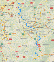
483:, the highest peak of the northern Vosges. After 246 kilometres (153 mi) (129 kilometres; 80 miles in France and on the
1137:
1117:
1097:
1107:
299:
1082:
826:
1132:
850:
1112:
843:
643:
The name Saar stems from the Celtic word sara (streaming water), and the Roman name of the river, saravus.
1122:
1092:
609:
17:
1127:
757:
ships. Since then, goods can be transported in northbound direction, for instance, to the sea port of
1087:
797:
484:
414:
966:
1142:
766:
625:
507:
594:
488:
201:
704:
460:
8:
1102:
951:
622:
585:
487:, and 117 kilometres; 73 miles in Germany) the Saar flows into the Moselle at Konz (
632:
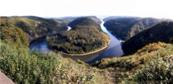
the Saar passes the well-known Saar loop. The lower Saar in
Rhineland-Palatinate is a
762:
511:
996:
911:
835:
452:
197:
107:
397:
991:
698:
534:
435:
427:
936:
931:
901:
722:
492:
565:
1076:
710:
577:
556:
522:
314:
301:
231:
217:
141:
127:
811:
569:
916:
716:
31:
1021:
941:
896:
770:
765:(also navigable for Class I ships) connects the Saar since 1866 with the
633:
543:
270:
530:
480:
498:
981:
758:
581:
573:
389:
740:
637:
629:
598:
561:
552:
539:
111:
986:
956:
867:
548:
526:
518:
476:
448:
444:
381:
285:
78:
906:
618:
589:
456:
440:
74:
46:
1016:
921:
881:
728:
692:
464:
385:
813:, Bundesministerium für Verkehr und digitale Infrastruktur (
926:
734:
674:
602:
815:
Federal
Ministry of Transport and Digital Infrastructure
58:
865:
495:
of 7,431 square kilometres (2,869 sq mi).
491:) between Trier and the Luxembourg border. It has a
651:Tributaries of the Saar are, from source to mouth:
1074:
851:
636:region of some importance, producing mostly
463:and flows northwards into the Moselle near
858:
844:
57:
798:"Fiche cours d'eau - La Sarre (A9--0100)"
788:
786:
608:
497:
396:
14:
1075:
613:Confluence of Saar and Moselle in Konz
839:
820:
783:
506:The Saar flows through the following
434:
413:
364:75 m/s (2,600 cu ft/s)
342:7,431 km (2,869 sq mi)
401:Bridge over the Saar at Saarbrücken
24:
792:
30:For the river in Switzerland, see
25:
1154:
965:
617:On the banks of the Saar is the
45:
447:, and a right tributary of the
1138:International rivers of Europe
1118:Rivers of Moselle (department)
1098:Rivers of Rhineland-Palatinate
804:
646:
467:. It has two headstreams (the
293: • coordinates
209: • coordinates
119: • coordinates
13:
1:
776:
748:
439:) is a river in northeastern
85:Physical characteristics
1108:Federal waterways in Germany
257: • elevation
167: • elevation
7:
281: • location
261:±670 m (2,200 ft)
193: • location
171:±800 m (2,600 ft)
103: • location
27:River in France and Germany
10:
1159:
1083:Tributaries of the Moselle
360: • average
29:
974:
963:
874:
866:Tributaries of the river
502:Course of the Saar (1703)
377:
372:
368:
358:
350:
346:
338:
334:246 km (153 mi)
330:
291:
279:
269:
265:
255:
207:
191:
183:
179:
175:
165:
117:
101:
93:
89:
84:
70:
65:
56:
44:
39:
479:), that both start near
614:
503:
431:
402:
1133:France–Germany border
612:
508:departments of France
501:
400:
51:Saar loop at Mettlach
595:Rhineland-Palatinate
489:Rhineland-Palatinate
485:French-German border
315:49.70139°N 6.56972°E
232:48.53472°N 7.16806°E
142:48.52694°N 7.16250°E
1113:Rivers of Grand Est
829:, Canal de la Sarre
623:World Heritage Site
373:Basin features
311: /
227: /
137: /
1123:Rivers of Bas-Rhin
1093:Rivers of Saarland
615:
504:
451:. It rises in the
403:
1128:Rivers of Germany
1070:
1069:
767:Marne–Rhine Canal
763:Canal de la Sarre
512:states of Germany
455:on the border of
395:
394:
320:49.70139; 6.56972
237:48.53472; 7.16806
147:48.52694; 7.16250
16:(Redirected from
1150:
1088:Rivers of France
969:
860:
853:
846:
837:
836:
830:
824:
818:
808:
802:
801:
790:
626:Völklinger Hütte
475:, which join in
453:Vosges mountains
438:
425:
424:
423:
417:
412:
361:
326:
325:
323:
322:
321:
316:
312:
309:
308:
307:
304:
258:
251:
250:
248:
247:
246:
244:
239:
238:
233:
228:
225:
224:
223:
220:
210:
198:Vosges mountains
194:
168:
161:
160:
158:
157:
156:
154:
149:
148:
143:
138:
135:
134:
133:
130:
120:
108:Vosges mountains
104:
61:
49:
37:
36:
21:
1158:
1157:
1153:
1152:
1151:
1149:
1148:
1147:
1073:
1072:
1071:
1066:
970:
961:
870:
864:
834:
833:
825:
821:
809:
805:
791:
784:
779:
751:
746:
649:
525:(Sarre Rouge),
419:
418:
415:[zaːɐ̯]
410:
359:
319:
317:
313:
310:
305:
302:
300:
298:
297:
294:
282:
256:
242:
240:
236:
234:
230:
229:
226:
221:
218:
216:
214:
213:
208:
192:
166:
152:
150:
146:
144:
140:
139:
136:
131:
128:
126:
124:
123:
118:
102:
52:
35:
28:
23:
22:
15:
12:
11:
5:
1156:
1146:
1145:
1140:
1135:
1130:
1125:
1120:
1115:
1110:
1105:
1100:
1095:
1090:
1085:
1068:
1067:
1065:
1064:
1059:
1054:
1049:
1044:
1039:
1034:
1029:
1024:
1019:
1014:
1009:
1004:
999:
994:
989:
984:
978:
976:
975:From the right
972:
971:
964:
962:
960:
959:
954:
949:
944:
939:
934:
929:
924:
919:
914:
909:
904:
899:
894:
889:
884:
878:
876:
872:
871:
863:
862:
855:
848:
840:
832:
831:
819:
803:
781:
780:
778:
775:
750:
747:
745:
744:
738:
732:
726:
720:
714:
708:
702:
696:
690:
684:
678:
672:
666:
660:
653:
648:
645:
607:
606:
592:
559:
546:
537:
493:catchment area
393:
392:
379:
375:
374:
370:
369:
366:
365:
362:
356:
355:
352:
348:
347:
344:
343:
340:
336:
335:
332:
328:
327:
295:
292:
289:
288:
283:
280:
277:
276:
273:
267:
266:
263:
262:
259:
253:
252:
211:
205:
204:
195:
189:
188:
185:
181:
180:
177:
176:
173:
172:
169:
163:
162:
121:
115:
114:
105:
99:
98:
95:
91:
90:
87:
86:
82:
81:
72:
68:
67:
63:
62:
54:
53:
50:
42:
41:
26:
9:
6:
4:
3:
2:
1155:
1144:
1143:Border rivers
1141:
1139:
1136:
1134:
1131:
1129:
1126:
1124:
1121:
1119:
1116:
1114:
1111:
1109:
1106:
1104:
1101:
1099:
1096:
1094:
1091:
1089:
1086:
1084:
1081:
1080:
1078:
1063:
1060:
1058:
1055:
1053:
1052:Altlayer Bach
1050:
1048:
1045:
1043:
1040:
1038:
1035:
1033:
1030:
1028:
1025:
1023:
1020:
1018:
1015:
1013:
1010:
1008:
1007:Olewiger Bach
1005:
1003:
1000:
998:
995:
993:
990:
988:
985:
983:
980:
979:
977:
973:
968:
958:
955:
953:
950:
948:
945:
943:
940:
938:
935:
933:
930:
928:
925:
923:
920:
918:
915:
913:
910:
908:
905:
903:
900:
898:
895:
893:
890:
888:
885:
883:
880:
879:
877:
875:From the left
873:
869:
861:
856:
854:
849:
847:
842:
841:
838:
828:
823:
816:
812:
807:
799:
795:
789:
787:
782:
774:
772:
768:
764:
760:
756:
742:
739:
736:
733:
730:
727:
724:
721:
718:
715:
712:
709:
706:
703:
700:
697:
694:
691:
688:
685:
682:
679:
676:
673:
670:
667:
664:
661:
658:
657:Sarre Blanche
655:
654:
652:
644:
641:
639:
635:
631:
627:
624:
620:
611:
604:
600:
596:
593:
591:
587:
583:
579:
575:
571:
567:
563:
560:
558:
557:Sarreguemines
554:
550:
547:
545:
541:
538:
536:
532:
528:
524:
523:Abreschviller
520:
517:
516:
515:
513:
509:
500:
496:
494:
490:
486:
482:
478:
474:
473:Sarre Blanche
470:
466:
462:
458:
454:
450:
446:
442:
437:
436:[saʁ]
433:
429:
422:
416:
408:
399:
391:
387:
383:
380:
376:
371:
367:
363:
357:
353:
349:
345:
341:
337:
333:
329:
324:
296:
290:
287:
284:
278:
274:
272:
268:
264:
260:
254:
249:
212:
206:
203:
199:
196:
190:
186:
182:
178:
174:
170:
164:
159:
153:Sarre Blanche
122:
116:
113:
109:
106:
100:
97:Sarre Blanche
96:
92:
88:
83:
80:
76:
73:
69:
64:
60:
55:
48:
43:
38:
33:
19:
1001:
822:
806:
752:
650:
642:
616:
505:
472:
468:
443:and western
406:
404:
32:Saar (Rhine)
1032:Ahringsbach
1022:Feller Bach
897:Rupt de Mad
827:Fluviacarte
771:Gondrexange
663:Sarre Rouge
647:Tributaries
634:winegrowing
566:Saarbrücken
544:Sarre-Union
514:and towns:
469:Sarre Rouge
378:Progression
318: /
243:Sarre Rouge
235: /
187:Sarre Rouge
145: /
18:Sarre river
1103:Saar basin
1077:Categories
1037:Kautenbach
777:References
749:Navigation
705:Köllerbach
570:Völklingen
535:Fénétrange
531:Sarrebourg
481:Mont Donon
339:Basin size
241: (
219:48°32′05″N
184:2nd source
151: (
129:48°31′37″N
1047:Flaumbach
1012:Avelsbach
982:Moselotte
952:Brohlbach
759:Rotterdam
586:Dillingen
582:Saarlouis
574:Wadgassen
390:North Sea
351:Discharge
306:6°34′11″E
303:49°42′5″N
222:7°10′05″E
132:7°09′45″E
71:Countries
1042:Lützbach
887:Terrouin
755:Class Vb
741:Leukbach
699:Rohrbach
638:Riesling
630:Mettlach
599:Saarburg
562:Saarland
553:Sarralbe
540:Bas-Rhin
461:Lorraine
112:Bas-Rhin
66:Location
1062:Ehrbach
1057:Baybach
992:Meurthe
987:Vologne
868:Moselle
731:(right)
725:(right)
723:Ellbach
707:(right)
701:(right)
695:(right)
689:(right)
677:(right)
671:(right)
665:(right)
549:Moselle
527:Lorquin
519:Moselle
477:Lorquin
449:Moselle
445:Germany
411:German:
382:Moselle
286:Moselle
202:Moselle
79:Germany
997:Seille
947:Endert
937:Lieser
912:Gander
907:Fensch
794:Sandre
743:(left)
737:(left)
719:(left)
713:(left)
711:Rossel
687:Eichel
683:(left)
669:Bièvre
659:(left)
619:UNESCO
590:Merzig
457:Alsace
441:France
428:French
354:
331:Length
275:
94:Source
75:France
1027:Dhron
1017:Ruwer
922:Sauer
882:Madon
729:Prims
693:Blies
628:. At
597:(D):
564:(D):
551:(F):
542:(F):
521:(F):
465:Trier
432:Sarre
386:Rhine
271:Mouth
1002:Saar
932:Salm
927:Kyll
917:Syre
902:Orne
892:Esch
735:Nied
717:Bist
681:Albe
675:Isch
603:Konz
578:Bous
471:and
459:and
407:Saar
405:The
77:and
40:Saar
957:Elz
942:Alf
773:.
769:at
588:,
1079::
796:.
785:^
601:,
584:,
580:,
576:,
572:,
568:,
555:,
533:,
529:,
510:,
430::
426:;
388:→
384:→
200:,
110:,
859:e
852:t
845:v
817:)
800:.
621:-
605:.
409:(
245:)
155:)
34:.
20:)
Text is available under the Creative Commons Attribution-ShareAlike License. Additional terms may apply.


