267:
374:
131:
246:
25:
444:
425:
268:
319:
apparently occurred in the south part of the crater during the eruption, which accounts for the disruption to the round shape of the mountain. During the Age of
Settlement, lava flowed from Svörtuborgir
341:
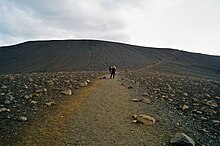
The rim of the crater is only accessible by two paths, from the northwest and south. It is strictly forbidden to use other routes in ascent or descent.
408:
332:, around Hverfjall, which was nearly engulfed by the lava. At the same time an eruption occurred in the slopes above the valley of Hlíðardalur
392:
163:
485:
519:
355:
89:
61:
108:
287:
224:
524:
68:
478:
46:
504:
360:
156:
75:
234:
429:
42:
57:
509:
471:
389:
35:
215:
514:
350:
8:
334:
328:
322:
316:
278:
261:
82:
459:
396:
455:
305:
498:
220:
178:
165:
373:
130:
245:
298:
24:
315:
Tephra has been carried from
Hverfjall all over the Mývatn area. A
312:
fissure swarm. The crater is approximately 1 km in diameter.
451:
294:
290:
227:
203:
424:
309:
283:
146:
443:
49:. Unsourced material may be challenged and removed.
496:
479:
486:
472:
109:Learn how and when to remove this message
372:
244:
497:
356:List of volcanic eruptions in Iceland
333:
327:
321:
277:
260:
438:
47:adding citations to reliable sources
18:
326:, at the southern end of Námafjall
135:The Hverfjall crater from the south
13:
14:
536:
418:
442:
423:
129:
23:
34:needs additional citations for
520:North Volcanic Zone of Iceland
402:
390:The Hverfjall fissure eruption
383:
1:
368:
458:. You can help Knowledge by
361:List of volcanoes in Iceland
308:in the southern part of the
7:
344:
16:Volcano in northern Iceland
10:
541:
437:
335:[ˈl̥iːðarˌtaːlʏr̥]
323:[ˈsvœr̥tʏˌpɔrcɪr̥]
151:420 m (1,380 ft)
233:
214:
209:
199:
194:
155:
145:
140:
128:
123:
411:Accessed 29 October 2008
409:Rough Guide on Hverfjall
399:Accessed 29 October 2008
329:[ˈnauːmaˌfjatl̥]
258:Icelandic pronunciation:
525:Iceland geography stubs
377:Inner rim of Hverfjall.
262:[ˈkʰvɛrˌfjatl̥]
454:location article is a
378:
279:[ˈkʰvɛrˌfɛtl̥]
250:
432:at Wikimedia Commons
376:
248:
179:65.60000°N 16.88333°W
505:Volcanoes of Iceland
351:Volcanism of Iceland
43:improve this article
304:It erupted in 2500
249:Trails to Hverfjall
184:65.60000; -16.88333
175: /
395:2011-07-28 at the
379:
251:
141:Highest point
467:
466:
428:Media related to
297:, to the east of
243:
242:
119:
118:
111:
93:
532:
510:Active volcanoes
488:
481:
474:
446:
439:
427:
412:
406:
400:
387:
337:
331:
325:
281:
273:; also known as
272:
271:
270:
264:
259:
190:
189:
187:
186:
185:
180:
176:
173:
172:
171:
168:
133:
121:
120:
114:
107:
103:
100:
94:
92:
51:
27:
19:
540:
539:
535:
534:
533:
531:
530:
529:
495:
494:
493:
492:
435:
421:
416:
415:
407:
403:
397:Wayback Machine
388:
384:
371:
347:
266:
265:
257:
183:
181:
177:
174:
169:
166:
164:
162:
161:
136:
115:
104:
98:
95:
52:
50:
40:
28:
17:
12:
11:
5:
538:
528:
527:
522:
517:
512:
507:
491:
490:
483:
476:
468:
465:
464:
447:
420:
419:External links
417:
414:
413:
401:
381:
380:
370:
367:
366:
365:
364:
363:
358:
346:
343:
241:
240:
237:
231:
230:
218:
212:
211:
207:
206:
201:
197:
196:
192:
191:
159:
153:
152:
149:
143:
142:
138:
137:
134:
126:
125:
117:
116:
31:
29:
22:
15:
9:
6:
4:
3:
2:
537:
526:
523:
521:
518:
516:
513:
511:
508:
506:
503:
502:
500:
489:
484:
482:
477:
475:
470:
469:
463:
461:
457:
453:
448:
445:
441:
440:
436:
433:
431:
426:
410:
405:
398:
394:
391:
386:
382:
375:
362:
359:
357:
354:
353:
352:
349:
348:
342:
339:
336:
330:
324:
318:
313:
311:
307:
302:
300:
296:
292:
289:
285:
280:
276:
269:
263:
255:
247:
238:
236:
235:Last eruption
232:
229:
226:
222:
219:
217:
216:Mountain type
213:
208:
205:
202:
198:
193:
188:
160:
158:
154:
150:
148:
144:
139:
132:
127:
122:
113:
110:
102:
91:
88:
84:
81:
77:
74:
70:
67:
63:
60: –
59:
55:
54:Find sources:
48:
44:
38:
37:
32:This article
30:
26:
21:
20:
515:Cinder cones
460:expanding it
449:
434:
422:
404:
385:
340:
314:
303:
293:in northern
274:
253:
252:
105:
96:
86:
79:
72:
65:
53:
41:Please help
36:verification
33:
221:Tephra cone
182: /
157:Coordinates
99:August 2021
58:"Hverfjall"
499:Categories
369:References
170:16°53′00″W
167:65°36′00″N
69:newspapers
430:Hverfjall
317:landslide
288:tuff ring
254:Hverfjall
225:tuff ring
195:Geography
147:Elevation
124:Hverfjall
393:Archived
345:See also
286:cone or
275:Hverfell
200:Location
452:Iceland
295:Iceland
291:volcano
282:) is a
239:2500 BP
228:volcano
210:Geology
204:Iceland
83:scholar
310:Krafla
299:Mývatn
284:tephra
85:
78:
71:
64:
56:
450:This
90:JSTOR
76:books
456:stub
62:news
45:by
501::
338:.
306:BP
301:.
223:,
487:e
480:t
473:v
462:.
256:(
112:)
106:(
101:)
97:(
87:·
80:·
73:·
66:·
39:.
Text is available under the Creative Commons Attribution-ShareAlike License. Additional terms may apply.

