405:
372:
250:
258:
29:
228:, one 2 miles (3.2 km) wide and two others about 1.5 miles (2.4 km) wide. Small peaks rising 2,000 feet (600 m) and 2,031 feet (619 m) are also present in the caldera. Fisher Caldera is located just 13 miles (21 km) from the
500:
475:
446:
61:
490:
439:
390:
319:
385:
432:
412:
465:
54:
485:
179:
495:
404:
480:
344:
288:
349:
470:
149:
225:
8:
420:
315:
249:
377:
210:
262:
239:
131:
416:
339:
229:
124:
117:
205:, measuring about 6.8 miles (11 km) by 11 miles (18 km), located on
459:
221:
206:
167:
154:
110:
101:
76:
63:
172:
163:
236:
218:
257:
202:
28:
214:
105:
44:
314:. Cambridge: Cambridge University Press. pp. 355–356.
242:(the last 11,700 years) occurred at Fisher Caldera in 8700
136:
243:
33:
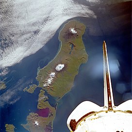
Satellite picture of Unimak Island with Fisher
Caldera
367:
235:The largest volcanic eruption on Earth during the
16:Volcanic caldera in the Aleutian Islands of Alaska
457:
501:Aleutians East Borough, Alaska geography stubs
303:
440:
253:Maps of Alaskan volcanoes with Fisher Caldera
289:"Fisher Caldera Description and Information"
476:Volcanoes of Aleutians East Borough, Alaska
309:
217:. Formed by the destructive eruption of an
447:
433:
310:Oppenheimer, Clive (2011). "Appendix A".
291:. Alaska Volcano Observatory. 4 June 2012
224:about 9,100 years ago, it contains three
256:
248:
458:
391:List of volcanoes in the United States
411:This article about a location in the
283:
281:
279:
491:Stratovolcanoes of the United States
399:
261:Aerial view of Fisher Caldera, with
13:
386:List of volcanic craters in Alaska
276:
14:
512:
332:
403:
370:
27:
413:Aleutians East Borough, Alaska
312:Eruptions that Shook the World
1:
269:
419:. You can help Knowledge by
49:3,648 ft (1,112 m)
7:
363:
10:
517:
398:
178:
161:
148:
143:
130:
116:
97:
92:
53:
43:
38:
26:
21:
345:Global Volcanism Program
350:Smithsonian Institution
266:
254:
201:, is a large volcanic
260:
252:
265:in upper left corner
466:Volcanoes of Alaska
73: /
486:Calderas of Alaska
267:
255:
77:54.667°N 164.383°W
39:Highest point
496:Holocene calderas
428:
427:
321:978-0-521-64112-8
188:
187:
508:
449:
442:
435:
407:
400:
380:
378:mountains portal
375:
374:
373:
359:
357:
356:
326:
325:
307:
301:
300:
298:
296:
285:
211:Aleutian Islands
193:, also known as
120:
88:
87:
85:
84:
83:
82:54.667; -164.383
78:
74:
71:
70:
69:
66:
31:
19:
18:
516:
515:
511:
510:
509:
507:
506:
505:
481:VEI-6 volcanoes
456:
455:
454:
453:
396:
376:
371:
369:
366:
354:
352:
338:
335:
330:
329:
322:
308:
304:
294:
292:
287:
286:
277:
272:
263:Eickelberg Peak
118:
109:
81:
79:
75:
72:
67:
64:
62:
60:
59:
34:
17:
12:
11:
5:
514:
504:
503:
498:
493:
488:
483:
478:
473:
468:
452:
451:
444:
437:
429:
426:
425:
408:
394:
393:
388:
382:
381:
365:
362:
361:
360:
334:
333:External links
331:
328:
327:
320:
302:
274:
273:
271:
268:
230:Mount Westdahl
199:Fisher Volcano
191:Fisher Caldera
186:
185:
182:
176:
175:
170:
159:
158:
152:
146:
145:
141:
140:
134:
128:
127:
125:Aleutian Range
122:
114:
113:
99:
95:
94:
90:
89:
57:
51:
50:
47:
41:
40:
36:
35:
32:
24:
23:
22:Fisher Caldera
15:
9:
6:
4:
3:
2:
513:
502:
499:
497:
494:
492:
489:
487:
484:
482:
479:
477:
474:
472:
471:Unimak Island
469:
467:
464:
463:
461:
450:
445:
443:
438:
436:
431:
430:
424:
422:
418:
414:
409:
406:
402:
401:
397:
392:
389:
387:
384:
383:
379:
368:
351:
347:
346:
341:
337:
336:
323:
317:
313:
306:
290:
284:
282:
280:
275:
264:
259:
251:
247:
245:
241:
238:
233:
231:
227:
223:
222:stratovolcano
220:
216:
212:
208:
207:Unimak Island
204:
200:
196:
192:
183:
181:
180:Last eruption
177:
174:
171:
169:
165:
160:
156:
155:Stratovolcano
153:
151:
150:Mountain type
147:
142:
138:
135:
133:
129:
126:
123:
121:
115:
112:
111:United States
107:
103:
102:Unimak Island
100:
96:
91:
86:
58:
56:
52:
48:
46:
42:
37:
30:
25:
20:
421:expanding it
410:
395:
353:. Retrieved
343:
311:
305:
293:. Retrieved
234:
226:crater lakes
198:
195:Mount Fisher
194:
190:
189:
173:Aleutian Arc
119:Parent range
184:August 1830
80: /
55:Coordinates
460:Categories
355:2021-06-27
270:References
295:15 August
232:volcano.
219:andesitic
162:Volcanic
139:Unimak C4
93:Geography
45:Elevation
364:See also
340:"Fisher"
237:Holocene
132:Topo map
98:Location
68:164°23′W
209:in the
203:caldera
157:remnant
144:Geology
65:54°40′N
318:
215:Alaska
106:Alaska
415:is a
240:Epoch
417:stub
316:ISBN
297:2012
197:and
168:belt
137:USGS
244:BCE
213:of
164:arc
462::
348:.
342:.
278:^
246:.
104:,
448:e
441:t
434:v
423:.
358:.
324:.
299:.
166:/
108:,
Text is available under the Creative Commons Attribution-ShareAlike License. Additional terms may apply.


