42:
26:
49:
240:
One of the original ideas proposed for linking
Birmingham to its southern neighbors was the Red Mountain Tunnel project. This was seriously considered by the city and state highway engineers. Two alternate routes were proposed, one starting at 18th Street and the other from 22nd Street. Eventually
198:
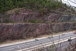
The resultant cut exposes geological strata spanning millions of years (150 million years of geological time within 650 feet or 200 metres of exposure), including the red ore seam that spurred
Birmingham's development. A new species of Lower Silurian (middle
399:
85:
241:
the tunnel idea was abandoned due to its high cost and extended amount of time it would have taken. The Red
Mountain Expressway Cut was built instead.
364:
409:
404:
394:
41:
274:
384:
187:. It has spurred suburban growth towards the south of Birmingham. This section also provides the route for
168:
78:
389:
369:
Red
Mountain Cut National Natural Landmark, U.S. 280 at Red Mountain, Birmingham, Jefferson County, AL
307:
229:
192:
164:
130:
188:
316:
184:
180:
414:
335:
8:
250:
172:
71:
281:
225:
176:
200:
217:, was first collected from exposures on Red Mountain. Named for the city, the new
212:
25:
378:
100:
87:
368:
207:
218:
204:
57:
371:", 2 photos, 8 data pages, 1 photo caption page
272:
175:. This highway links Birmingham with its southern suburbs of
191:(US 31) to the south (the Montgomery Highway) and
167:
that was blasted and removed in the 1960s to allow the
336:"Tunnel Board Pondering Two Routes Under Red Mountain"
30:
Looking east across the Red
Mountain Expressway Cut.
48:
280:. National Park Service. p. 1. Archived from
376:
400:Historic American Engineering Record in Alabama
312:, a new lower Silurian trilobite from Alabama"
275:"National Registry of Natural Landmarks"
305:
377:
410:Transportation in Birmingham, Alabama
405:National Natural Landmarks in Alabama
268:
266:
365:Historic American Engineering Record
273:National Natural Landmarks Program.
13:
263:
235:
14:
426:
358:
395:Geography of Birmingham, Alabama
47:
40:
24:
328:
299:
131:U.S. National Natural Landmark
1:
385:Freeways in the United States
256:
7:
306:Norford, B. S. (May 1972).
244:
221:was published in May 1972.
161:Red Mountain Geological Cut
157:Red Mountain Expressway Cut
19:Red Mountain Expressway Cut
10:
431:
230:National Natural Landmark
149:
145:
137:
128:
124:
116:
77:
67:
35:
23:
18:
367:(HAER) No. AL-85, "
317:Journal of Paleontology
169:Red Mountain Expressway
310:Acaste birminghamensis
120:8 acres (3.2 ha)
159:, also known as the
251:Birmingham District
173:Birmingham, Alabama
97: /
72:Birmingham, Alabama
390:Geology of Alabama
195:to the southeast.
189:U.S. Route 31
171:to enter downtown
163:, is a section of
228:was designated a
153:
152:
101:33.496°N 86.788°W
422:
352:
351:
349:
347:
332:
326:
325:
303:
297:
296:
294:
292:
286:
279:
270:
201:Llandovery epoch
112:
111:
109:
108:
107:
102:
98:
95:
94:
93:
90:
51:
50:
44:
28:
16:
15:
430:
429:
425:
424:
423:
421:
420:
419:
375:
374:
361:
356:
355:
345:
343:
342:. February 1947
340:Birmingham News
334:
333:
329:
304:
300:
290:
288:
284:
277:
271:
264:
259:
247:
238:
236:Proposed tunnel
215:birminghamensis
133:
106:33.496; -86.788
105:
103:
99:
96:
91:
88:
86:
84:
83:
63:
62:
61:
60:
54:
53:
52:
31:
12:
11:
5:
428:
418:
417:
412:
407:
402:
397:
392:
387:
373:
372:
360:
359:External links
357:
354:
353:
327:
298:
287:on 16 May 2011
261:
260:
258:
255:
254:
253:
246:
243:
237:
234:
185:Vestavia Hills
181:Mountain Brook
151:
150:
147:
146:
143:
142:
139:
135:
134:
129:
126:
125:
122:
121:
118:
114:
113:
81:
75:
74:
69:
65:
64:
55:
46:
45:
39:
38:
37:
36:
33:
32:
29:
21:
20:
9:
6:
4:
3:
2:
427:
416:
415:U.S. Route 31
413:
411:
408:
406:
403:
401:
398:
396:
393:
391:
388:
386:
383:
382:
380:
370:
366:
363:
362:
341:
337:
331:
324:(3): 348–352.
323:
319:
318:
313:
311:
302:
283:
276:
269:
267:
262:
252:
249:
248:
242:
233:
231:
227:
222:
220:
216:
214:
209:
206:
202:
196:
194:
190:
186:
182:
178:
174:
170:
166:
162:
158:
148:
144:
140:
136:
132:
127:
123:
119:
115:
110:
82:
80:
76:
73:
70:
66:
59:
43:
34:
27:
22:
17:
344:. Retrieved
339:
330:
321:
315:
309:
301:
289:. Retrieved
282:the original
239:
223:
211:
197:
165:Red Mountain
160:
156:
154:
346:October 26,
193:US 280
104: /
79:Coordinates
379:Categories
257:References
138:Designated
92:86°47′17″W
89:33°29′46″N
232:in 1987.
208:trilobite
205:phacopsid
291:7 August
245:See also
177:Homewood
68:Location
219:species
58:Alabama
56:Map of
213:Acaste
183:, and
285:(PDF)
278:(PDF)
348:2012
293:2011
224:The
155:The
141:1987
117:Area
226:cut
381::
338:.
322:46
320:.
314:.
265:^
210:,
203:)
179:,
350:.
308:"
295:.
Text is available under the Creative Commons Attribution-ShareAlike License. Additional terms may apply.

