228:
50:
220:
236:
buffalo carts are used as a means of transportation between Yubu Island and
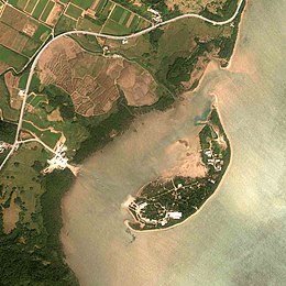
Iriomote Island, and have become an important tourist attraction for the island. When it is low tide and the waves are calm, it is possible to cross between islands on foot. Utility poles are built in the sea from Iriomote Island to Yubu Island in order to guide foot traffic. A botanical garden encompasses most of the island.
235:
Yubu Island is a small island with a total area of 0.15 km and a circumference of 2.0 km. It is located 0.5 km east of
Iriomote Island. The water level between Yubu Island and Iriomote Island is usually no more than around knee deep, even during high tide the maximum depth is around 1 meter. Water
266:
On April 1, 1981, the "Subtropical
Botanical Garden" was opened on the island. The garden has gradually expanded over time to encompass most of the island. The island is a popular tourist attraction to visitors of Iriomote because of its botanical garden and water buffalo cart rides. In 2017,
314:
256:
to
Iriomote Island, established a settlement on Yubu Island. Fruit trees and sugar canes were cultivated, and water buffaloes were raised.
260:
84:
208:
321:
344:
8:
253:
227:
159:
263:
struck Yubu Island and most of the island's inhabitants moved to
Iriomote soon after.
169:
49:
249:
204:
196:
119:
338:
99:
86:
72:
290:
231:
Water buffalo carts carrying people between
Iriomote Island and Yubu Island
245:
267:
approximately 201,600 tourist visited Yubu, with a peak day of 1,117.
219:
292:
200:
291:
The Yubu Island
Subtropical Botanical Garden (2021-09-28).
54:
Yubu Island (right) next to
Iriomote Island (left), 2012
336:
188:
28:
182:
35:
312:
214:
48:
226:
218:
203:, it is located about 0.5 miles east of
337:
286:
284:
282:
280:
248:, in 1947, people who migrated from
129:0.15 km (0.058 sq mi)
13:
211:" encompasses most of the island.
14:
356:
277:
306:
1:
313:Taketomi Town (May 4, 2020).
270:
209:Subtropical Botanical Garden
16:Island within Ryukyu Islands
7:
189:
29:
10:
361:
239:
223:Street view of Yubu Island
183:
165:
155:
146:
141:
133:
125:
115:
78:
68:
63:
59:
47:
36:
24:
137:1.9 m (6.2 ft)
259:On September 26, 1969,
215:Geography and transport
315:"竹富町地区別人口動態票(令和2年3月末)"
232:
224:
134:Highest elevation
100:24.34500°N 123.93500°E
230:
222:
195:is an island of the
105:24.34500; 123.93500
96: /
21:
233:
225:
160:Okinawa Prefecture
19:
175:
174:
170:Taketomi, Okinawa
352:
329:
328:
326:
320:. Archived from
319:
310:
304:
303:
301:
300:
288:
254:Kuroshima Island
194:
192:
186:
185:
111:
110:
108:
107:
106:
101:
97:
94:
93:
92:
89:
52:
41:
39:
38:
32:
22:
18:
360:
359:
355:
354:
353:
351:
350:
349:
345:Yaeyama Islands
335:
334:
333:
332:
324:
317:
311:
307:
298:
296:
289:
278:
273:
250:Taketomi Island
242:
217:
205:Iriomote Island
197:Yaeyama Islands
180:
151:
120:Yaeyama Islands
104:
102:
98:
95:
90:
87:
85:
83:
82:
55:
43:
42:
33:
17:
12:
11:
5:
358:
348:
347:
331:
330:
327:on 2020-05-04.
305:
275:
274:
272:
269:
241:
238:
216:
213:
173:
172:
167:
163:
162:
157:
153:
152:
147:
144:
143:
142:Administration
139:
138:
135:
131:
130:
127:
123:
122:
117:
113:
112:
80:
76:
75:
70:
66:
65:
61:
60:
57:
56:
53:
45:
44:
27:
25:
15:
9:
6:
4:
3:
2:
357:
346:
343:
342:
340:
323:
316:
309:
295:(in Japanese)
294:
287:
285:
283:
281:
276:
268:
264:
262:
261:Typhoon Elsie
257:
255:
251:
247:
237:
229:
221:
212:
210:
206:
202:
198:
191:
179:
171:
168:
164:
161:
158:
154:
150:
145:
140:
136:
132:
128:
124:
121:
118:
114:
109:
81:
77:
74:
73:Pacific Ocean
71:
67:
62:
58:
51:
46:
31:
26:Native name:
23:
322:the original
308:
297:. Retrieved
265:
258:
243:
234:
177:
176:
148:
246:Pacific War
178:Yubu Island
116:Archipelago
103: /
91:123°56′06″E
79:Coordinates
20:Yubu Island
299:2022-08-08
271:References
244:After the
156:Prefecture
88:24°20′42″N
190:Yubu-jima
64:Geography
30:Yubu-jima
339:Category
293:"由布島の歴史"
69:Location
240:History
207:. The "
325:(PDF)
318:(PDF)
201:Japan
149:Japan
252:and
166:Town
126:Area
199:of
184:由布島
37:由布島
341::
279:^
187:,
302:.
193:)
181:(
40:)
34:(
Text is available under the Creative Commons Attribution-ShareAlike License. Additional terms may apply.


