89:
416:
55:
65:
321:
40:
80:
297:
In 2001, the village of
Rockanje had 4805 inhabitants. The built-up area of the village was 1.2 km, and contained 2004 residences. The statistical area "Rockanje", which also can include the peripheral parts of the village, as well as the surrounding countryside, has a population of around
88:
342:
372:
481:
457:
476:
106:
162:
262:
491:
450:
93:
The village centre (dark green) and the statistical district (light green) of
Rockanje in the former municipality of
443:
254:
150:
138:
64:
39:
486:
233:
243:
8:
54:
314:
431:
386:
427:
291:
287:
167:
470:
423:
283:
155:
121:
108:
279:
143:
301:
Rockanje was a separate municipality until 1980, when it became part of
415:
302:
94:
224:
79:
30:
320:
250:
229:
357:
347:. (Statistics are for the continuous built-up area).
359:Statline: Kerncijfers wijken en buurten 2003-2005
468:
451:
458:
444:
319:
290:, and lies about 7 km northwest of
482:Former municipalities of South Holland
469:
286:. It is a part of the municipality of
384:
373:Repertorium van Nederlandse gemeenten
190:29.75 km (11.49 sq mi)
182:30.03 km (11.59 sq mi)
16:Village in South Holland, Netherlands
410:
371:Ad van der Meer and Onno Boonstra,
350:
198:0.26 km (0.10 sq mi)
13:
344:Bevolkingskernen in Nederland 2001
335:
14:
503:
477:Populated places in South Holland
414:
87:
78:
63:
53:
38:
378:
365:
356:Statistics Netherlands (CBS),
341:Statistics Netherlands (CBS),
1:
492:South Holland geography stubs
328:
430:. You can help Knowledge by
7:
10:
508:
409:
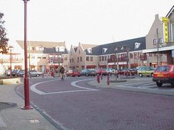
44:Village centre of Rockanje
308:
261:
240:
223:
215:
207:
202:
194:
186:
178:
173:
161:
149:
137:
102:
86:
77:
49:
37:
28:
21:
387:"Meet Annelous Lammerts"
362:. As of January 1, 2005.
317:was born here in 1993.
219:220/km (570/sq mi)
426:location article is a
325:
323:
242: • Summer (
385:Mikel (2012-04-02).
278:is a village in the
216: • Density
122:51.87056°N 4.06889°E
118: /
326:
208: • Total
195: • Water
179: • Total
439:
438:
324:Rockanje in 1866.
315:Annelous Lammerts
273:
272:
187: • Land
127:51.87056; 4.06889
499:
460:
453:
446:
418:
411:
401:
400:
398:
397:
382:
376:
369:
363:
354:
348:
339:
247:
133:
132:
130:
129:
128:
123:
119:
116:
115:
114:
111:
91:
82:
67:
57:
42:
19:
18:
507:
506:
502:
501:
500:
498:
497:
496:
467:
466:
465:
464:
407:
405:
404:
395:
393:
383:
379:
370:
366:
355:
351:
340:
336:
331:
313:The windsurfer
311:
269:
241:
126:
124:
120:
117:
112:
109:
107:
105:
104:
98:
73:
72:
71:
70:
61:
60:
45:
33:
24:
17:
12:
11:
5:
505:
495:
494:
489:
487:Voorne aan Zee
484:
479:
463:
462:
455:
448:
440:
437:
436:
419:
403:
402:
377:
375:, KNAW, 2011.
364:
349:
333:
332:
330:
327:
310:
307:
292:Hellevoetsluis
288:Voorne aan Zee
271:
270:
267:
265:
259:
258:
248:
238:
237:
227:
221:
220:
217:
213:
212:
209:
205:
204:
200:
199:
196:
192:
191:
188:
184:
183:
180:
176:
175:
171:
170:
168:Voorne aan Zee
165:
159:
158:
153:
147:
146:
141:
135:
134:
100:
99:
92:
84:
83:
75:
74:
68:
62:
58:
52:
51:
50:
47:
46:
43:
35:
34:
29:
26:
25:
22:
15:
9:
6:
4:
3:
2:
504:
493:
490:
488:
485:
483:
480:
478:
475:
474:
472:
461:
456:
454:
449:
447:
442:
441:
435:
433:
429:
425:
424:South Holland
420:
417:
413:
412:
408:
392:
388:
381:
374:
368:
361:
360:
353:
346:
345:
338:
334:
322:
318:
316:
306:
304:
299:
295:
293:
289:
285:
284:South Holland
281:
277:
266:
264:
260:
256:
252:
249:
245:
239:
235:
231:
228:
226:
222:
218:
214:
210:
206:
201:
197:
193:
189:
185:
181:
177:
172:
169:
166:
164:
160:
157:
156:South Holland
154:
152:
148:
145:
142:
140:
136:
131:
103:Coordinates:
101:
96:
90:
85:
81:
76:
66:
56:
48:
41:
36:
32:
27:
20:
432:expanding it
421:
406:
394:. Retrieved
390:
380:
367:
358:
352:
343:
337:
312:
300:
296:
282:province of
275:
274:
163:Municipality
69:Coat of arms
391:Ridersguide
263:Postal code
144:Netherlands
125: /
471:Categories
396:2024-07-16
329:References
303:Westvoorne
203:Population
110:51°52′14″N
95:Westvoorne
225:Time zone
276:Rockanje
151:Province
23:Rockanje
139:Country
113:4°4′8″E
31:Village
309:People
298:5710.
422:This
280:Dutch
251:UTC+2
230:UTC+1
211:6,560
428:stub
268:3235
255:CEST
174:Area
59:Flag
244:DST
234:CET
473::
389:.
305:.
294:.
459:e
452:t
445:v
434:.
399:.
257:)
253:(
246:)
236:)
232:(
97:.
Text is available under the Creative Commons Attribution-ShareAlike License. Additional terms may apply.


