464:
47:
440:
476:
92:
125:
72:
452:
62:
132:
99:
393:
The Dutch
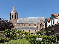
Reformed church is a basilica like cruciform church which was dedicated to St Pancratius. The lower parts of the tower date from around 1350. The church was rebuilt after a fire in 1586. During a restoration in 1778, the entire choir was removed.
401:
De
Korenaar was built in 1710. The wind mill started to lean during construction and is smaller than intended. In 2010s, the displacement was 66 centimeters. In 1950, an electro motor was installed. In 2010, it was restored and back in service until 2018.
463:
731:
700:
46:
842:
439:
160:
866:
216:
91:
724:
308:
475:
861:
320:
379:
and streaming water. Poortvliet is a circular church village. The
Poortvlietpolder and the Mallandpolder are the oldest
124:
717:
741:
596:
71:
424:
was merged with
Poortvliet. Poortvliet remained a separate municipality until 1971, when it was merged with
300:
204:
805:
586:
451:
671:
192:
709:
414:
375:
The village was first mentioned in 1200 as
Portfliet, and the name is a combination of words for
61:
831:
619:
279:
221:
289:
17:
8:
505:
413:
intended for
Antwerp which killed four people. Poortvliet was severely affected by the
209:
800:
775:
592:
380:
871:
556:
410:
364:
339:
855:
826:
795:
780:
421:
175:
162:
790:
405:
Poortvliet was home to 1,113 people in 1840. Poortvliet was evacuated and
645:
584:
352:
197:
810:
398:
344:
270:
406:
739:
530:
356:
759:
745:
425:
387:
360:
296:
275:
376:
111:
Location in the province of
Zeeland in the Netherlands
585:Piet van Cruyningen & Ronald Stenvert (2003).
853:
843:List of cities, towns and villages in Zeeland
725:
695:
693:
732:
718:
690:
580:
578:
575:
363:and lies about 12 km northwest of
854:
500:
498:
496:
359:. It is a part of the municipality of
713:
701:Repertorium van Nederlandse gemeenten
638:
338:
664:
506:"Kerncijfers wijken en buurten 2021"
236:22.18 km (8.56 sq mi)
699:Ad van der Meer and Onno Boonstra,
493:
445:Steam pumping station Oosterschelde
13:
557:"Poortvliet - (geografische naam)"
523:
131:
98:
14:
883:
867:Former municipalities of Zeeland
474:
462:
450:
438:
409:in 1944. In 1945, it was hit by
130:
123:
97:
90:
70:
60:
45:
537:(in Dutch). Het Waterschapshuis
535:Actueel Hoogtebestand Nederland
25:Village in Zeeland, Netherlands
612:
591:(in Dutch). Zwolle: Waanders.
549:
1:
486:
510:Central Bureau of Statistics
7:
862:Populated places in Zeeland
10:
888:
431:
386:s of the former island of
370:
244:−0.5 m (−1.6 ft)
15:
840:
819:
768:
752:
531:"Postcodetool for 4693BA"
319:
307:
286:
269:
261:
253:
248:
240:
232:
227:
215:
203:
191:
156:
84:
56:
44:
37:
30:
740:Populated places in the
420:In 1813, the village of
144:Poortvliet (Netherlands)
51:The St Pancratius Church
415:North Sea flood of 1953
147:Show map of Netherlands
469:Entrance to the church
351:) is a village in the
265:77/km (200/sq mi)
457:Wind mill De Korenaar
288: • Summer (
340:[ˈpoːrtflit]
336:Dutch pronunciation:
262: • Density
176:51.54444°N 4.14417°E
18:Poortvliet (surname)
16:For other uses, see
172: /
114:Show map of Zeeland
481:Farm in Poortvliet
254: • Total
233: • Total
849:
848:
801:Sint-Maartensdijk
776:Anna Jacobapolder
329:
328:
181:51.54444; 4.14417
879:
806:Sint Philipsland
734:
727:
720:
711:
710:
704:
697:
688:
687:
685:
683:
668:
662:
661:
659:
657:
642:
636:
635:
633:
631:
616:
610:
609:
607:
605:
582:
573:
572:
570:
568:
553:
547:
546:
544:
542:
527:
521:
520:
518:
516:
502:
478:
466:
454:
442:
342:
337:
293:
187:
186:
184:
183:
182:
177:
173:
170:
169:
168:
165:
148:
134:
133:
127:
115:
101:
100:
94:
74:
64:
49:
28:
27:
887:
886:
882:
881:
880:
878:
877:
876:
852:
851:
850:
845:
836:
815:
764:
748:
738:
708:
707:
698:
691:
681:
679:
670:
669:
665:
655:
653:
644:
643:
639:
629:
627:
618:
617:
613:
603:
601:
599:
583:
576:
566:
564:
555:
554:
550:
540:
538:
529:
528:
524:
514:
512:
504:
503:
494:
489:
482:
479:
470:
467:
458:
455:
446:
443:
434:
411:V-1 flying bomb
373:
335:
315:
287:
180:
178:
174:
171:
166:
163:
161:
159:
158:
152:
151:
150:
149:
146:
145:
142:
141:
140:
139:
135:
118:
117:
116:
113:
112:
109:
108:
107:
106:
102:
80:
79:
78:
77:
68:
67:
52:
40:
33:
26:
21:
12:
11:
5:
885:
875:
874:
869:
864:
847:
846:
841:
838:
837:
835:
834:
829:
823:
821:
817:
816:
814:
813:
808:
803:
798:
793:
788:
783:
778:
772:
770:
766:
765:
763:
762:
756:
754:
750:
749:
737:
736:
729:
722:
714:
706:
705:
703:, KNAW, 2011.
689:
663:
637:
611:
597:
574:
561:Etymologiebank
548:
522:
491:
490:
488:
485:
484:
483:
480:
473:
471:
468:
461:
459:
456:
449:
447:
444:
437:
433:
430:
372:
369:
365:Bergen op Zoom
327:
326:
323:
317:
316:
313:
311:
305:
304:
294:
284:
283:
273:
267:
266:
263:
259:
258:
255:
251:
250:
246:
245:
242:
238:
237:
234:
230:
229:
225:
224:
219:
213:
212:
207:
201:
200:
195:
189:
188:
154:
153:
143:
137:
136:
129:
128:
122:
121:
120:
119:
110:
104:
103:
96:
95:
89:
88:
87:
86:
85:
82:
81:
75:
69:
65:
59:
58:
57:
54:
53:
50:
42:
41:
38:
35:
34:
31:
24:
9:
6:
4:
3:
2:
884:
873:
870:
868:
865:
863:
860:
859:
857:
844:
839:
833:
830:
828:
825:
824:
822:
818:
812:
809:
807:
804:
802:
799:
797:
796:Sint-Annaland
794:
792:
789:
787:
784:
782:
781:Oud-Vossemeer
779:
777:
774:
773:
771:
767:
761:
758:
757:
755:
751:
747:
743:
735:
730:
728:
723:
721:
716:
715:
712:
702:
696:
694:
677:
676:Zalig Zeeland
673:
667:
651:
647:
641:
625:
624:Molendatabase
621:
620:"De Korenaar"
615:
600:
598:90 400 8830 6
594:
590:
589:
581:
579:
562:
558:
552:
536:
532:
526:
511:
507:
501:
499:
497:
492:
477:
472:
465:
460:
453:
448:
441:
436:
435:
429:
427:
423:
422:Nieuw-Strijen
418:
416:
412:
408:
403:
400:
395:
391:
389:
385:
382:
378:
368:
366:
362:
358:
354:
350:
346:
341:
333:
324:
322:
318:
312:
310:
306:
302:
298:
295:
291:
285:
281:
277:
274:
272:
268:
264:
260:
256:
252:
247:
243:
239:
235:
231:
226:
223:
220:
218:
214:
211:
208:
206:
202:
199:
196:
194:
190:
185:
157:Coordinates:
155:
126:
93:
83:
73:
63:
55:
48:
43:
36:
29:
23:
19:
791:Scherpenisse
785:
742:municipality
680:. Retrieved
675:
672:"Poortvliet"
666:
654:. Retrieved
650:Plaatsengids
649:
646:"Poortvliet"
640:
628:. Retrieved
623:
614:
602:. Retrieved
587:
565:. Retrieved
560:
551:
539:. Retrieved
534:
525:
513:. Retrieved
509:
419:
404:
396:
392:
383:
374:
355:province of
348:
331:
330:
321:Dialing code
217:Municipality
76:Coat of arms
22:
309:Postal code
198:Netherlands
179: /
856:Categories
811:Stavenisse
786:Poortvliet
678:(in Dutch)
652:(in Dutch)
626:(in Dutch)
588:Poortvliet
563:(in Dutch)
487:References
399:grist mill
332:Poortvliet
249:Population
164:51°32′40″N
138:Poortvliet
105:Poortvliet
32:Poortvliet
832:Westkerke
407:inundated
345:Zeelandic
271:Time zone
241:Elevation
769:Villages
682:22 April
656:22 April
630:22 April
604:22 April
567:22 April
541:22 April
515:22 April
349:Poôfliet
205:Province
167:4°8′39″E
820:Hamlets
432:Gallery
371:History
357:Zeeland
210:Zeeland
193:Country
39:Village
872:Tholen
760:Tholen
746:Tholen
595:
426:Tholen
388:Tholen
384:polder
361:Tholen
222:Tholen
827:Sluis
753:Towns
381:diked
353:Dutch
297:UTC+2
276:UTC+1
257:1,715
684:2022
658:2022
632:2022
606:2022
593:ISBN
569:2022
543:2022
517:2022
397:The
377:port
325:0166
314:4693
301:CEST
228:Area
66:Flag
744:of
417:.
290:DST
280:CET
858::
692:^
674:.
648:.
622:.
577:^
559:.
533:.
508:.
495:^
428:.
390:.
367:.
347::
343:;
733:e
726:t
719:v
686:.
660:.
634:.
608:.
571:.
545:.
519:.
334:(
303:)
299:(
292:)
282:)
278:(
20:.
Text is available under the Creative Commons Attribution-ShareAlike License. Additional terms may apply.


