156:
149:
296:
26:
305:
These mountains have not seen extensive exploration, due to their remoteness, typically poor weather, and lack of truly high peaks. However they are rugged and offer many climbing possibilities of an exploratory nature. Noted climber
310:
visited the range in the early 1970s; in 1991, when he was "spiritual leader" of the expedition which made the first ascent of Mount
Neacola; and again in 2004. Other recorded climbing visits occurred in 1979 and 1995.
468:
463:
201:
66:
267:
130:
423:
270:
which bounds it to the north and drains the highest and most rugged peaks of the group. They are bordered on the southeast by the
283:
148:
414:
419:
409:
194:
59:
290:(also known as "Neacola Peak"), 9,426 feet (2,873 m) although the name is not officially recognized.
458:
8:
279:
271:
380:
353:
275:
259:
233:
452:
287:
216:
203:
81:
68:
307:
124:
263:
49:
282:, and on the west and southwest by the lakes and lowlands of
295:
25:
326:
248:
Chigmit
Mountains, Tordrillo Mountains and Alaska Range
442:
The USGS GNIS does not contain an entry for this peak.
450:
469:Mountains of Lake and Peninsula Borough, Alaska
375:
373:
464:Mountains of Kenai Peninsula Borough, Alaska
370:
348:
346:
343:
155:
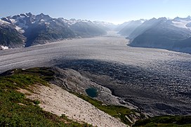
30:Blockade Glacier in the Neacola Mountains
424:United States Department of the Interior
294:
106:88 mi (142 km) North-South
114:157 mi (253 km) East-West
451:
404:
402:
400:
327:Wood, Michael; Coombs, Colby (2001).
284:Lake Clark National Park and Preserve
258:are the northernmost subrange of the
415:Geographic Names Information System
397:
13:
14:
480:
154:
147:
24:
420:United States Geological Survey
299:Meadow in the Neacola Mountains
436:
1:
336:
266:. The range is named for the
168:Location of Neacola Mountains
54:9,426 ft (2,873 m)
7:
10:
485:
314:
278:, on the northeast by the
274:, another subrange of the
323:, 1980, 1992, 1996, 2005.
244:
232:
193:
185:
177:
141:
136:
123:
118:
110:
102:
97:
58:
48:
40:
35:
23:
18:
329:Alaska: a climbing guide
321:American Alpine Journal
300:
286:. The highest peak is
82:60.79861°N 153.39389°W
298:
262:in the U.S. state of
87:60.79861; -153.39389
410:"Neacola Mountains"
381:"Neacola Mountains"
331:. The Mountaineers.
280:Tordrillo Mountains
213: /
78: /
301:
217:60.617°N 154.083°W
36:Highest point
272:Chigmit Mountains
256:Neacola Mountains
252:
251:
195:Range coordinates
162:Neacola Mountains
19:Neacola Mountains
476:
443:
440:
434:
433:
431:
430:
406:
395:
394:
392:
391:
377:
368:
367:
365:
364:
350:
332:
236:
228:
227:
225:
224:
223:
222:60.617; -154.083
218:
214:
211:
210:
209:
206:
158:
157:
151:
93:
92:
90:
89:
88:
83:
79:
76:
75:
74:
71:
28:
16:
15:
484:
483:
479:
478:
477:
475:
474:
473:
449:
448:
447:
446:
441:
437:
428:
426:
408:
407:
398:
389:
387:
379:
378:
371:
362:
360:
354:"Mount Neacola"
352:
351:
344:
339:
317:
303:
302:
234:
221:
219:
215:
212:
207:
204:
202:
200:
199:
173:
172:
171:
170:
169:
166:
165:
164:
163:
159:
86:
84:
80:
77:
72:
69:
67:
65:
64:
31:
12:
11:
5:
482:
472:
471:
466:
461:
459:Aleutian Range
445:
444:
435:
396:
385:Peakbagger.com
369:
358:Peakbagger.com
341:
340:
338:
335:
334:
333:
324:
316:
313:
293:
292:
276:Aleutian Range
260:Aleutian Range
250:
249:
246:
242:
241:
240:Aleutian Range
238:
230:
229:
197:
191:
190:
187:
183:
182:
179:
175:
174:
167:
161:
160:
153:
152:
146:
145:
144:
143:
142:
139:
138:
134:
133:
129:Named for the
127:
121:
120:
116:
115:
112:
108:
107:
104:
100:
99:
95:
94:
62:
56:
55:
52:
46:
45:
42:
38:
37:
33:
32:
29:
21:
20:
9:
6:
4:
3:
2:
481:
470:
467:
465:
462:
460:
457:
456:
454:
439:
425:
421:
417:
416:
411:
405:
403:
401:
386:
382:
376:
374:
359:
355:
349:
347:
342:
330:
325:
322:
319:
318:
312:
309:
297:
291:
289:
288:Mount Neacola
285:
281:
277:
273:
269:
268:Neacola River
265:
261:
257:
247:
243:
239:
237:
231:
226:
198:
196:
192:
188:
184:
181:United States
180:
176:
150:
140:
135:
132:
131:Neacola River
128:
126:
122:
117:
113:
109:
105:
101:
96:
91:
63:
61:
57:
53:
51:
47:
44:Mount Neacola
43:
39:
34:
27:
22:
17:
438:
427:. Retrieved
413:
388:. Retrieved
384:
361:. Retrieved
357:
328:
320:
304:
255:
253:
235:Parent range
308:Fred Beckey
220: /
85: /
73:153°23′38″W
60:Coordinates
453:Categories
429:2007-12-09
390:2014-11-16
363:2014-11-16
337:References
245:Borders on
98:Dimensions
70:60°47′55″N
137:Geography
125:Etymology
50:Elevation
208:154°05′W
315:Sources
205:60°37′N
178:Country
264:Alaska
189:Alaska
119:Naming
103:Length
186:State
111:Width
254:The
41:Peak
455::
422:,
418:.
412:.
399:^
383:.
372:^
356:.
345:^
432:.
393:.
366:.
Text is available under the Creative Commons Attribution-ShareAlike License. Additional terms may apply.


