218:
27:
39:
229:
was built on
Manamansalo in 1559. It became the center of the Oulujärvi parish, separated from Liminka on that year. The church was destroyed by Russians in 1581, after which the Oulujärvi parish was reintegrated into Liminka. A new church was built in
238:. Manamansalo remained part of Paltamo until Säräisniemi was separated from it in 1864. The Säräisniemi municipality was renamed Vaala in 1954 after its seat was moved from the village of Säräisniemi to the village of Vaala.
196:
The road 8820 (Manamansalontie) goes through the island. The northeastern part has a bridge connected to the mainland, but crossing the
Alassalmi strait in the southwest has to be done via the
241:
An open-air church was built on the island in 1959 in commemoration of the 400th anniversary of the original church. It is located on the same site as the 16th century church.
401:
59:
320:
473:
375:
349:
265:
483:
409:
193:
The main village on the island is also known as
Manamansalo. Other villages include Puronranta and Unelanperä.
478:
210:
Manamansalo was settled by Finns in the 16th century. It was first mentioned in 1555 as a part of the
432:"Varastettu kirkonkello kumisi tarinoissa - löytyi Venäjältä satoja vuosia myöhemmin - Yle Uutiset"
463:
245:
8:
170:
until 2016. It is the seventh largest inland island in
Finland, or the fifth largest if
175:
163:
294:
197:
468:
217:
457:
74:
61:
151:
116:
26:
231:
186:
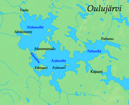
Manamansalo is located between the Ärjänselkä and
Niskanselkä areas (
235:
211:
171:
155:
226:
167:
38:
431:
187:
159:
126:
248:
of Russia in the 1970s, having been brought there in 1596.
234:
in 1599, after which the reestablished parish was known as
402:"Manamansalon muistomerkkikirkko - Vaalan seurakunta"
244:
The bell of the 16th century church was found in the
321:"SuomalainenPaikannimikirja_e-kirja_kuvallinen.pdf"
455:
37:
25:
216:
456:
158:. Administratively it belongs to the
43:Map of Oulujärvi showing Manamansalo
13:
295:"Karttapaikka - Maanmittauslaitos"
14:
495:
16:Island in the country of Finland
474:Geography of North Ostrobothnia
94:76 km (29 sq mi)
424:
394:
368:
342:
313:
287:
266:"Suomi: Saarten ja vetten maa"
258:
1:
299:asiointi.maanmittauslaitos.fi
251:
221:The memorial open-air church.
150:is the largest island in the
408:(in Finnish). Archived from
181:
178:are not counted as islands.
154:, the fifth largest lake in
7:
225:The first church in all of
10:
500:
376:"Suomen Sukututkimusseura"
350:"Suomen Sukututkimusseura"
205:
330:(in Finnish). p. 260
137:
132:
122:
112:
103:
98:
90:
75:64.3592527°N 27.0607030°E
53:
48:
36:
24:
484:Lake islands of Finland
275:(in Finnish). p. 6
222:
80:64.3592527; 27.0607030
220:
246:Solovetsky Monastery
479:Geography of Kainuu
406:vaalanseurakunta.fi
380:hiski.genealogia.fi
354:hiski.genealogia.fi
71: /
21:
223:
164:North Ostrobothnia
19:
145:
144:
31:Kultahiekat beach
491:
448:
447:
445:
443:
428:
422:
421:
419:
417:
412:on July 13, 2015
398:
392:
391:
389:
387:
372:
366:
365:
363:
361:
346:
340:
339:
337:
335:
325:
317:
311:
310:
308:
306:
291:
285:
284:
282:
280:
270:
262:
190:) of Oulujärvi.
162:municipality in
86:
85:
83:
82:
81:
76:
72:
69:
68:
67:
64:
41:
29:
22:
18:
499:
498:
494:
493:
492:
490:
489:
488:
454:
453:
452:
451:
441:
439:
430:
429:
425:
415:
413:
400:
399:
395:
385:
383:
374:
373:
369:
359:
357:
348:
347:
343:
333:
331:
323:
319:
318:
314:
304:
302:
293:
292:
288:
278:
276:
268:
264:
263:
259:
254:
208:
198:Alassalmi Ferry
184:
108:
79:
77:
73:
70:
65:
62:
60:
58:
57:
44:
32:
17:
12:
11:
5:
497:
487:
486:
481:
476:
471:
466:
450:
449:
423:
393:
367:
341:
328:kaino.kotus.fi
312:
286:
256:
255:
253:
250:
207:
204:
183:
180:
143:
142:
139:
135:
134:
130:
129:
124:
123:Municipalities
120:
119:
114:
110:
109:
104:
101:
100:
99:Administration
96:
95:
92:
88:
87:
55:
51:
50:
46:
45:
42:
34:
33:
30:
15:
9:
6:
4:
3:
2:
496:
485:
482:
480:
477:
475:
472:
470:
467:
465:
462:
461:
459:
437:
433:
427:
411:
407:
403:
397:
381:
377:
371:
355:
351:
345:
329:
322:
316:
300:
296:
290:
274:
267:
261:
257:
249:
247:
242:
239:
237:
233:
228:
219:
215:
213:
203:
201:
199:
194:
191:
189:
179:
177:
176:Sääminginsalo
173:
169:
165:
161:
157:
153:
149:
140:
136:
131:
128:
125:
121:
118:
115:
111:
107:
102:
97:
93:
89:
84:
56:
52:
47:
40:
35:
28:
23:
442:December 28,
440:. Retrieved
438:(in Finnish)
435:
426:
416:December 28,
414:. Retrieved
410:the original
405:
396:
386:December 28,
384:. Retrieved
382:(in Finnish)
379:
370:
360:December 28,
358:. Retrieved
356:(in Finnish)
353:
344:
334:December 28,
332:. Retrieved
327:
315:
305:December 28,
303:. Retrieved
301:(in Finnish)
298:
289:
279:December 28,
277:. Retrieved
272:
260:
243:
240:
224:
209:
202:
195:
192:
185:
147:
146:
133:Demographics
105:
148:Manamansalo
78: /
54:Coordinates
20:Manamansalo
458:Categories
252:References
232:Paltaniemi
66:27°03′39″E
63:64°21′33″N
464:Oulujärvi
182:Geography
152:Oulujärvi
138:Languages
117:Oulujärvi
49:Geography
214:parish.
236:Paltamo
212:Liminka
206:History
172:Soisalo
156:Finland
141:Finnish
106:Finland
436:mmm.fi
273:mmm.fi
227:Kainuu
188:fjards
168:Kainuu
469:Vaala
324:(PDF)
269:(PDF)
166:, or
160:Vaala
127:Vaala
444:2022
418:2022
388:2022
362:2022
336:2022
307:2022
281:2022
174:and
113:Lake
91:Area
460::
434:.
404:.
378:.
352:.
326:.
297:.
271:.
200:.
446:.
420:.
390:.
364:.
338:.
309:.
283:.
Text is available under the Creative Commons Attribution-ShareAlike License. Additional terms may apply.


