46:
74:
29:
122:
81:
53:
278:
The colony was located on
Eastern Bay between two present-day piers and down Kent Fort Road. Three wooden wells were located approximately 75 feet off shore and other artifacts were found in the vicinity. Notable were blue Indian trade beads which dated to 1631 from other sites. Also found were
260:, the Indigenous tribe of the island. Beads imported from Italy were given to the Matapeake people in exchange for furs. By the end of the century, however, activity had shifted northward to the port town of
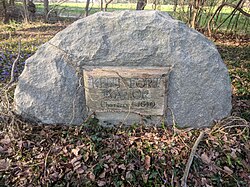
275:, and the only known traces of the settlement are well bases in the bay. A stone marker marks where the settlement was located, and Kent Fort Manor is also located at the site of the Kent Fort settlement.
441:
490:
188:
141:
485:
470:
475:
434:
73:
460:
45:
427:
296:
465:
322:
403:
480:
256:
in 1631, and was a central part of early Kent Island. Claiborne made Kent Fort into a trading post with the
348:
134:
279:
melted beads which were probably in a fire recorded in the store house which burned on
October 17, 1631.
372:
249:
415:
261:
217:
109:
225:
8:
327:
241:
221:
253:
245:
352:
257:
411:
300:
454:
237:
203:
190:
156:
143:
127:
28:
272:
33:
A stoner marker on Kent Island, near the historic location of the fort.
407:
233:
268:
229:
376:
236:
and the fourth oldest permanent
English settlement in the
16:
Human settlement in "Kent Island, Maryland", Maryland, US
349:"Kent Island: Third Oldest US Settlement - 2002-02-19"
267:
Today, the land on which the fort once stood has been
297:"Historic Sites and Landmarks of Queen Annes County"
452:
435:
80:
52:
442:
428:
373:"Kent Fort Manor - Kent Island Maryland"
491:Eastern Shore, Maryland geography stubs
185:was a fort and settlement located near
88:Kent Fort, Maryland (the United States)
453:
320:
486:Populated places in colonial Maryland
252:(1620). The fort was established by
471:English-American culture in Maryland
397:
232:settlement within the boundaries of
476:Former populated places in Maryland
13:
14:
502:
402:This article about a location in
120:
79:
72:
51:
44:
27:
461:1631 establishments in Maryland
323:"Somewhere Over the Bay Bridge"
365:
341:
314:
289:
1:
282:
91:Show map of the United States
414:. You can help Knowledge by
321:Smardz, Zofia (2007-07-11).
7:
10:
507:
466:Colonial forts in Maryland
396:
172:
133:
115:
105:
100:
38:
26:
21:
60:Location within Maryland
250:Plymouth, Massachusetts
481:Kent Island, Maryland
110:Kent Island, Maryland
234:present-day Maryland
228:, and was the first
63:Show map of Maryland
404:Queen Anne's County
328:The Washington Post
242:Jamestown, Virginia
200: /
153: /
101:General information
423:
422:
254:William Claiborne
246:Hampton, Virginia
222:colonial Virginia
180:
179:
498:
444:
437:
430:
398:
388:
387:
385:
384:
375:. Archived from
369:
363:
362:
360:
359:
353:Voice of America
345:
339:
338:
336:
335:
318:
312:
311:
309:
308:
299:. Archived from
293:
258:Matapeake people
215:
214:
212:
211:
210:
205:
201:
198:
197:
196:
193:
168:
167:
165:
164:
163:
158:
154:
151:
150:
149:
146:
126:
124:
123:
92:
83:
82:
76:
64:
55:
54:
48:
31:
19:
18:
506:
505:
501:
500:
499:
497:
496:
495:
451:
450:
449:
448:
394:
392:
391:
382:
380:
371:
370:
366:
357:
355:
347:
346:
342:
333:
331:
319:
315:
306:
304:
295:
294:
290:
285:
248:(1609–10), and
208:
206:
204:38.84°N 76.37°W
202:
199:
194:
191:
189:
187:
186:
161:
159:
157:38.84°N 76.37°W
155:
152:
147:
144:
142:
140:
139:
121:
119:
96:
95:
94:
93:
90:
89:
86:
85:
84:
67:
66:
65:
62:
61:
58:
57:
56:
34:
17:
12:
11:
5:
504:
494:
493:
488:
483:
478:
473:
468:
463:
447:
446:
439:
432:
424:
421:
420:
390:
389:
364:
340:
313:
287:
286:
284:
281:
178:
177:
174:
170:
169:
137:
131:
130:
117:
113:
112:
107:
103:
102:
98:
97:
87:
78:
77:
71:
70:
69:
68:
59:
50:
49:
43:
42:
41:
40:
39:
36:
35:
32:
24:
23:
15:
9:
6:
4:
3:
2:
503:
492:
489:
487:
484:
482:
479:
477:
474:
472:
469:
467:
464:
462:
459:
458:
456:
445:
440:
438:
433:
431:
426:
425:
419:
417:
413:
409:
405:
400:
399:
395:
379:on 2008-06-02
378:
374:
368:
354:
350:
344:
330:
329:
324:
317:
303:on 2016-06-02
302:
298:
292:
288:
280:
276:
274:
270:
265:
263:
259:
255:
251:
247:
243:
239:
238:United States
235:
231:
227:
223:
219:
213:
209:38.84; -76.37
184:
175:
171:
166:
162:38.84; -76.37
138:
136:
132:
129:
118:
114:
111:
108:
104:
99:
75:
47:
37:
30:
25:
20:
416:expanding it
401:
393:
381:. Retrieved
377:the original
367:
356:. Retrieved
343:
332:. Retrieved
326:
316:
305:. Retrieved
301:the original
291:
277:
266:
216:on southern
182:
181:
106:Town or city
273:Eastern Bay
262:Broad Creek
218:Kent Island
207: /
160: /
135:Coordinates
455:Categories
383:2008-05-16
358:2023-08-13
334:2013-03-09
307:2009-11-28
283:References
224:and later
271:into the
183:Kent Fort
173:Completed
22:Kent Fort
408:Maryland
244:(1607),
240:, after
226:Maryland
230:English
195:76°22′W
192:38°50′N
148:76°22′W
145:38°50′N
116:Country
269:eroded
125:
410:is a
412:stub
176:1631
220:in
128:USA
457::
406:,
351:.
325:.
264:.
443:e
436:t
429:v
418:.
386:.
361:.
337:.
310:.
Text is available under the Creative Commons Attribution-ShareAlike License. Additional terms may apply.


