3912:(RPII) reported that in 2005 average quantities of radioactive contamination found in seafood ranged from less than 1 Bq/kg (12 pCi/lb) for fish to under 44 Bq/kg (540 pCi/lb) for mussels. Doses of man-made radioactivity received by the heaviest consumers of seafood in Ireland in 2005 was 1.10 μSv (0.000110 rem). This compares with a corresponding dosage of radioactivity naturally occurring in the seafood consumed by this group of 148 μSv (0.0148 rem) and a total average dosage in Ireland from all sources of 3,620 μSv (0.362 rem). In terms of risk to this group, heavy consumption of seafood generates a 1 in 18 million chance of causing cancer. The general risk of contracting cancer in Ireland is 1 in 522. In the UK, the heaviest seafood consumers in Cumbria received a radioactive dosage attributable to Sellafield discharges of 220 μSv (0.022 rem) in 2005. This compares to average annual dose of naturally sourced radiation received in the UK of 2,230 μSv (0.223 rem).
1020:
43:
5510:
5527:
271:
3961:
1361:
3901:. The highest concentration is found in the eastern Irish Sea in sediment banks lying parallel to the Cumbrian coast. This area acts as a significant source of wider contamination as radionuclides are dissolved once again. Studies have revealed that 80% of current seawater contamination by caesium is sourced from sediment banks, whilst plutonium levels in the western sediment banks between the Isle of Man and the Irish coast are being maintained by contamination redistributed from the eastern sediment banks.
1097:
1072:, such as those that crop out nearby on the coastline of north Wales. (Floodpage et al., 1999) have invoked this second phase of Paleogene hydrocarbon generation as an important factor in the charging of the East Irish Sea Basin's oil and gas fields. It is not clear as yet whether aeromagnetic anomalies in the southeast of Caernarfon Bay are imaging a continuation of the dyke swarm into this area too, or whether they are instead associated with deeply buried Permian syn-rift
6819:
7199:
6807:
300:
1133:, or earlier if Cretaceous strata, now missing, were never deposited in the basin. Despite the Tertiary structuration, the Dragon discovery has proved that potentially commercial volumes of hydrocarbons were retained at least locally in Cardigan Bay. In addition to undrilled structural traps, the basin contains the untested potential for stratigraphic entrapment of hydrocarbons near synsedimentary faults, especially in the Middle Jurassic section.
290:
31:
1215:
263:
1652:
1498:
1536:
1702:
1686:
1444:
1426:
1388:
1864:
1768:
1736:
1636:
1462:
1408:
1784:
1720:
1518:
1368:
1848:
1588:
1480:
1800:
1670:
1604:
1832:
1572:
1554:
1816:
1752:
1620:
1346:
undrilled prospect still has significant risk and the partners are currently advancing a focused work programme in order to better understand and hopefully mitigate these risks. However, given its location in shallow water and close proximity to shore, the prospect is of great interest as exploration drilling, together with any future development costs, are likely to be low.
1113:
up to 2 km (1.2 mi) of
Paleogene fluvio-deltaic sediments. The basin has a proven petroleum system, with potentially producible gas reserves at the Dragon discovery near the UK/ROI median line, and oil shows in a further three wells. The Cardigan Bay Basin contains multiple reservoir targets, which include the Lower Triassic (Sherwood Sandstone),
3893:
after peak discharge. Less soluble elements such as plutonium are subject to much slower redistribution. Whilst concentrations have declined in line with the reduction in discharges they are markedly higher in the eastern Irish Sea compared to the western areas. The dispersal of these elements is closely associated with sediment activity, with
3586:
larger body of salt water until wind and temperature changes mix it in. Similarly, warmer water is less dense and seawater warmed in the inter-tidal zone may "float" on the colder offshore water. The amount of light penetrating the seawater also varies with depth and turbidity. This leads to differing populations of
5423:
3634:, dominate the zooplankton. However, many animals of the seabed, the open sea and the seashore spend their juvenile stages as part of the zooplankton. The whole plankton "soup" is vitally important, directly or indirectly, as a food source for most species in the Irish Sea, even the largest. The enormous
3942:. The idea for a 34-kilometre (21 mi) long rail bridge or tunnel continues to be mooted. Several potential projects have been proposed, including one between Dublin and Holyhead put forward in 1997 by the British engineering firm Symonds. At 80 km (50 mi), it would have been by far the
1112:
near the Welsh coastline, although its internal structure becomes increasingly complex towards the southwest. Permian to
Triassic, syn-rift sediments within the basin are less than 3 km (1.9 mi) thick and are overlain by up to 4 km (2.5 mi) of Jurassic strata, and locally also by
3892:
being flushed out of the Irish Sea through the North
Channel about a year after discharge. Measurements of technetium concentrations post-1994 has produced estimated transit times to the North Channel of around six months with peak concentrations off the northeast Irish coast occurring 18–24 months
3490:
of the seabed of the Irish Sea is rather patchy because it is difficult to survey such a large area, where underwater visibility is often poor and information often depends upon looking at material brought up from the seabed in mechanical grabs. However, the groupings of animals present depend to a
1128:
marine mudstones. These are fully mature for oil generation in the west of the
British sector and are mature for gas generation nearby in the Irish sector. Gas-prone, Westphalian pre-rift coal measures may also be present at depth locally. The Cardigan Bay Basin was subjected to two Tertiary phases
3585:
The open sea is a complex habitat in its own right. It exists in three spatial dimensions and also varies over time and tide. For example, where freshwater flows into the Irish Sea in river estuaries its influence can extend far offshore as the freshwater is lighter and "floats" on top of the much
1345:
exploration prospect, may be prospective for oil, as there are prolific oil productive Lower
Triassic reservoirs nearby in the eastern Irish Sea offshore Liverpool. Whilst the Dalkey Island exploration prospect could contain about 870 million barrels (140,000,000 m) of oil in place, this
1196:
The
Liverpool Bay development comprises four offshore platforms. Offshore storage and loading facilities. The onshore gas processing terminal at Point of Ayr. Production first started at each field as follows: Hamilton North in 1995, Hamilton in 1996, Douglas in 1996, Lennox (oil only) in 1996 and
3880:
in particular rose from 6.1 TBq (160 Ci) in 1993 to a peak of 192 TBq (5,200 Ci) in 1995 before dropping back to 14 TBq (380 Ci) in 2004. In total 22 petabecquerels (590 kCi) of Pu was discharged over the period 1952 to 1998. Current rates of discharge for many
1165:
Oil is produced from the Lennox and
Douglas fields. It is then treated at the Douglas Complex and piped 17 km (11 mi) to an oil storage barge ready for export by tankers. Gas is produced from the Hamilton, Hamilton North and Hamilton East reservoirs. After initial processing at the
4138:, King of the Island of the Mighty. Branwen and Matholwch marry, but when she becomes abused by Matholwch, her brother crosses the sea from Wales to Ireland to rescue her. Within the story the Irish Sea is said to be shallow; in addition, it contains two rivers, the Lli and the Archan.
3863:
waste has been discharged into the Irish Sea as part of operations at
Sellafield since 1952. The rate of discharge began to accelerate in the mid- to late 1960s, reaching a peak in the 1970s and generally declining significantly since then. As an example of this profile, discharges of
3590:
in different parts of the sea and varying communities of animals that feed on these populations. However, increasing seasonal storminess leads to greater mixing of water and tends to break down these divisions, which are more apparent when the weather is calm for long periods.
4937:
4926:
1336:
has confirmed the potential for petroleum generation with oil shows seen in a number of wells together with natural hydrocarbon seeps recorded from airborne surveys. New analysis of vintage 2-D seismic data has revealed the presence of a large undrilled structural closure at
5420:
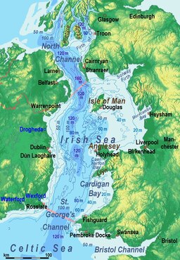
467:. It is composed of a deeper channel about 300 km (190 mi) long and 30–50 km (20–30 mi) wide on its western side and shallower bays to the east. The depth of the western channel ranges from 80 m (260 ft) to 275 m (900 ft).
477:, are less than 50 m (160 ft) deep. With a total water volume of 2,430 km (580 cu mi) and a surface area of 47,000 km (18,000 sq mi), 80% is to the west of the Isle of Man. The largest sandbanks are the
1046:. As in the East Irish Sea Basin, the principal target reservoir is the Lower Triassic, Sherwood Sandstone, top-sealed by younger Triassic mudstones and evaporites. Wells in the Irish Sector to the west have demonstrated that pre-rift,
4934:
4923:
3732:
all frequent the Irish Sea, but knowledge of how many there may be and where they go is somewhat sketchy. About a dozen species have been recorded since 1980, but only three are seen fairly often. These are the
1200:
The quality of the water in
Liverpool Bay was historically contaminated by dumping of sewage sludge at sea but this practice became illegal in December 1988 and no further sludge was deposited after that date.
5715:
3676:. These build up large structures over many years and, in turn, provide surfaces, nooks and crannies where other marine animals and plants may become established and live out some or all of their lives.
1275:
With 210 billion cubic metres (7.5 trillion cubic feet) of natural gas and 176 million barrels (28,000,000 m) of petroleum estimated by the field operators as initially recoverable
3872:) peaked in 1973 at 2,755 terabecquerels (74,500 Ci) falling to 8.1 TBq (220 Ci) by 2004. Improvements in the treatment of waste in 1985 and 1994 resulted in further reductions in
3691:
are found very occasionally in the Irish Sea but are generally unwell or dead when discovered. They have strayed or been swept out of their natural range further south into colder waters.
4516:
489:, Codling Bank, Arklow Bank and Blackwater Bank near the coast of Ireland. The Irish Sea, at its greatest width, is 200 km (120 mi) and narrows to 75 km (47 mi).
3664:. Some of the most significant for other wildlife are the reef-building species like the inshore horse mussel of Strangford Lough, the inter-tidal honeycomb worm of Morecambe Bay,
1060:
The timing of gas generation presents the greatest exploration risk. Maximum burial of, and primary gas migration from, the source rocks could have terminated as early as the
6857:
5106:
423:. Annual traffic between Great Britain and Ireland is over 12 million passengers and 17 million tonnes (17,000,000 long tons; 19,000,000 short tons) of traded goods.
3624:
that propel them through the water. Phytoplankton populations in the Irish Sea have a spring "bloom" every April and May, when the seawater is generally at its greenest.
3554:
are found in more gravelly areas. In the estuaries, where the bed is more sandy or muddy, the number of species is smaller but the size of their populations is larger.
1108:
Basin forms a continuation into
British waters of Ireland's North Celtic Sea Basin, which has two producing gas fields. The basin comprises a south-easterly deepening
5858:
R. W. Ryan; A. Dowdall; M. F. Fegan; E. Hayden; K. Kelleher; S. Long; I. McEvoy; L. McKittrick; C. A. McMahon; M. Murray; K. Smith; S. Sequeira; J. Wong; D. Pollard.
3542:
Parts of the bed of the Irish Sea are very rich in wildlife. The seabed southwest of the Isle of Man is particularly noted for its rarities and diversity, as are the
5697:
5576:
5183:
4868:
5152:
The Past, Current and Future Radiological Impact of the Sellafield Marine Discharges on the People Living in the Coastal Communities Surrounding the Irish Sea,
5073:
7267:
5395:
4952:
Barne, J.H., Robson, C.F., Kaznowska, S.S., Doody, J.P., & Davidson, N.C., eds. 1996. Coasts and seas of the United Kingdom. Region 13 Northern Irish Sea:
3888:
Analysis of the distribution of radioactive contamination after discharge reveals that mean sea currents result in much of the more soluble elements such as
5134:
4657:
5263:
1313:
reservoirs. This play requires intraformational mudstone seal units to be present, as there is no top-seal for reservoirs sub cropping the regional base
1068:
inversion of the basin. However, it is also possible that a secondary gas charge occurred during regional heating associated with intrusion of Paleogene
5554:
4582:
4174:
3926:
Discussions of linking Britain to Ireland began in 1895, with an application for £15,000 towards the cost of carrying out borings and soundings in the
3679:
There are quite regular records of live and stranded leatherback turtles in and around the Irish Sea. This species travels north to the waters off the
4119:
6850:
5489:
5465:
1333:
125:
5270:, Transfer of conservative and non-conservative radionuclides from the Sellafield Nuclear Fuel Reprocessing plant to the coastal waters of Ireland
3876:
discharge although the subsequent processing of a backlog resulted in increased discharges of certain types of radioactive waste. Discharges of
5156:
3816:
breed in Strangford Lough, grey seals in southwest Wales and, in small numbers, on the Isle of Man. Grey seals haul out, but do not breed, off
4344:
4509:
721:
handle 7.6 million tonnes (7,500,000 long tons; 8,400,000 short tons), representing 50% and 40% respectively of total trade by weight.
7232:
6843:
5868:
3955:
3909:
4697:
4612:
4541:
4382:
4369:
Cambridge Medieval Celtic Studies, Issues 33–35 University of Cambridge (Gran Bretaña). Department of Anglo-Saxon, Norse and Celtic 1997
1057:
clearly image these strata continuing beneath a basal Permian unconformity into at least the western part of the Caernarfon Bay Basin.
4788:
4677:
4322:
2918:
Listed are the islands in the Irish Sea which are either at least one square kilometre in area, or which have a permanent population.
603:
ended and was replaced by warmer conditions. At the height of the glaciation, the central part of the modern sea was probably a long
504:
436:
334:
330:
4760:
7272:
3921:
411:
to the west. The Irish Sea is of significant economic importance to regional trade, shipping and transport, as well as fishing and
4844:
5371:
5098:
4418:
1019:
493:
1129:
of compressive uplift, whereas maximum burial that terminated primary hydrocarbon generation was probably around the end of the
5966:
5859:
4903:
5901:
5744:
5067:
4996:
4965:
1031:
basin contains up to 7 cubic kilometres (1.7 cu mi) of Permian and Triassic syn-rift sediments in an asymmetrical
5839:
4685:
3620:
dominate the phytoplankton. Although they are microscopic plants, diatoms have hard shells and dinoflagellates have little
5666:
4842:. eds. P.Saundry & C.Cleveland. Encyclopedia of Earth. National Council for Science and the Environment. Washington DC
4482:
1291:
formation, principally the aeolian Sherwood Sandstone reservoir, top-sealed by younger Triassic continental mudstones and
7277:
7227:
5803:
3938:
MP for North Belfast, called for the building of such a tunnel. A tunnel project has been discussed several times in the
3927:
3904:
The consumption of seafood harvested from the Irish Sea is the main pathway for exposure of humans to radioactivity. The
1145:'s largest operated asset. It comprises the integrated development of five offshore oil and gas fields in the Irish Sea:
1042:. Only two exploration wells have been drilled so far, and there remain numerous undrilled targets in tilted fault block
5584:
5283:
5223:
5180:
4731:
743:
Ports in the Republic handle 3,600,000 travellers crossing the sea each year, amounting to 92% of all Irish Sea travel.
5929:
5606:
4860:
4812:
4169:
1360:
7237:
5934:
5052:
4637:
1262:
728:
handles 32 million tonnes (31,000,000 long tons; 35,000,000 short tons) of cargo and 734,000 passengers a year.
713:
ports handle 10 million tonnes (9,800,000 long tons; 11,000,000 short tons) of goods trade with the rest of the
209:
78:
5392:
1244:
7282:
4044:
Thirty 90-metre (300 ft) 3 MW turbines are operating in a wind farm 7 km (4.3 mi) the coast of
3233:
1279:
reserves from eight producing fields (DTI, 2001), the East Irish Sea Basin is at a mature exploration phase. Early
5759:
4184:
1879:
1287:
are the source rocks for these hydrocarbons. Production from all fields is from fault-bounded traps of the Lower
5127:
5030:
4654:
1240:
5441:
5260:
3706:
and Africa. Others depend on the milder climate as a refuge when continental Europe is in the grip of winter.
4028:
3801:
to the Irish Sea was claimed to be logically and ethically feasible; it has not been implemented as of 2013.
5544:
5008:
4574:
3694:
The estuaries of the Irish Sea are of international importance for birds. They are vital feeding grounds on
2414:
925:
893:
861:
829:
7262:
7257:
7242:
4189:
1053:
are excellent hydrocarbon source rocks, and are at peak maturity for gas generation (Maddox et al., 1995).
567:
532:
5486:
5462:
5912:
4389:
7035:
6185:
5959:
4988:
3762:
1236:
1183:
634:
624:
5636:
4754:"DTI Strategic Environmental Assessment Area 6, Irish Sea, seabed and surficial geology and processes"
7247:
5781:
4789:"Petroleum prospectivity of the principal sedimentary basins on the United Kingdom Continental Shelf"
3845:
3770:
3713:
are reported as regularly nesting on beaches or cliffs around the Irish Sea. Huge populations of the
3652:
live in the Irish Sea and its surrounding coastline, ranging from flower-like fan-worms to predatory
686:
674:
650:
5153:
5403:
4256:
4248:
4142:
3905:
3428:
1225:
976:
381:
4348:
740:
ports, as well as 3.3 million tonnes (3,200,000 long tons; 3,600,000 short tons) of freight.
6137:
3943:
3774:
1229:
990:
sank in the Irish sea and was discovered in March 2020. In September 2021, the British Navy ship
7252:
6458:
4318:
1142:
452:
326:
987:
5983:
5979:
5952:
5191:
4701:
4604:
4549:
4261:
3976:
3897:
deposits on the seabed acting as sinks, soaking up an estimated 200 kg (440 lb) of
3019:
2925:
218:
110:
4131:
42:
6999:
6305:
4795:
4179:
4038:
3782:
3566:
in Morecambe Bay and the Dee Estuary and the estuaries are also important as nurseries for
3536:
2841:
2544:
2358:
2311:
2280:
1676:
1626:
1341:
level situated about 10 kilometres (6 mi) offshore Dublin. This feature, known as the
956:
599:
The Irish Sea has undergone a series of dramatic changes over the last 20,000 years as the
5829:
Luis León Vintró; Kilian J. Smith; Julie A. Lucey; Peter I. Mitchell (4–6 December 2000).
4674:
4306:
8:
7165:
6606:
6400:
6029:
5416:
4753:
4414:
3935:
3136:
3106:
2072:
1578:
1296:
1047:
718:
600:
420:
408:
313:
is a 46,007 km (17,763 sq mi) body of water that separates the islands of
283:
270:
154:
3602:) that drift in the sea. Most are microscopic, but some, such as the various species of
7222:
6601:
6498:
6142:
6004:
5179:
Monitoring our Environment – Discharges and Monitoring in the UK – Annual Report 2004,
5164:
4838:
4155:
4150:
3790:
3738:
3639:
2901:
2523:
2471:
2445:
2342:
2332:
2264:
2186:
2160:
2150:
2134:
2108:
2056:
2030:
2004:
1952:
1659:
1561:
620:
522:
482:
6835:
5368:
1303:, but there remains largely untested potential also for gas and oil within widespread
7125:
7004:
6360:
6310:
6102:
6044:
5897:
5740:
5707:
5549:
5531:
5514:
5497:
5473:
5063:
4992:
4961:
4794:. United Kingdom: Department of Trade and Industry. 11 September 2002. Archived from
4445:
3939:
3873:
3860:
3684:
3543:
3452:
2124:
1506:
820:
763:
755:
725:
5872:
3683:
every year following the swarms of jellyfish that form its prey. Loggerhead turtle,
3519:
seven types of community have been provisionally identified, variously dominated by
435:
at both its northern and southern ends. To the north, the connection is through the
6621:
6473:
6024:
5944:
4900:
4314:
4063:
4032:
3960:
3829:
3734:
3579:
3575:
3559:
3448:
2881:
2674:
1190:
995:
710:
694:
508:
444:
412:
404:
242:
2409:
1709:
1354:
Below is a list of cities and towns around the Irish Sea coasts in order of size:
737:
275:
7040:
6969:
6964:
6948:
6907:
6741:
6711:
6691:
6611:
6275:
6270:
6255:
6225:
6190:
6112:
6009:
5799:
5763:
5493:
5469:
5447:
5427:
5399:
5375:
5287:
5267:
5227:
5187:
5160:
5138:
4941:
4930:
4907:
4848:
4681:
4661:
4641:
4056:
3786:
3555:
3464:
3377:
2176:
1543:
1178:
gas terminal for further processing. The gas is then sent by onshore pipeline to
1171:
1167:
1121:), and Upper Jurassic fluvial sandstone, the reservoir for the Dragon discovery.
1114:
759:
666:
7150:
6385:
5830:
4347:(in Manx). Centre for Manx Studies ("Laare-Studeyrys Manninagh"). Archived from
3991:, the world's first commercial application of offshore wind turbines over three
7180:
7170:
6989:
6974:
6867:
6681:
6661:
6626:
6616:
6596:
6591:
6586:
6415:
6405:
6295:
6280:
6162:
6014:
5991:
5795:
5674:
4486:
4277:
4269:
4240:
4227:
4216:
4208:
4100:
4093:
3980:
3930:
to see if a tunnel between Ireland and Scotland was viable. Sixty years later,
3758:
3742:
3695:
3617:
3492:
3440:
3424:
3173:
2861:
2851:
2622:
2570:
2285:
1338:
1300:
1280:
1125:
1069:
1043:
1028:
714:
561:
432:
366:
358:
230:
150:
144:
3721:, spend winters feeding in shallow waters off eastern Ireland, Lancashire and
1002:
in 1918 and discovered in 2022. This ship is well known for sailing near the
7216:
7203:
7140:
7110:
7080:
7070:
7045:
6994:
6984:
6902:
6823:
6811:
6631:
6523:
6493:
6478:
6468:
6448:
6375:
6345:
6300:
6290:
6265:
6245:
6215:
6195:
6107:
6082:
5711:
5280:
5220:
4723:
4449:
4232:
4146:
4135:
4067:
4045:
3965:
3882:
3869:
3849:
3821:
3817:
3798:
3718:
3680:
3635:
3595:
3551:
3444:
3432:
3143:
3083:
3051:
2809:
2729:
2709:
2596:
2388:
2383:
1973:
1921:
1692:
1342:
1304:
1186:
1064:, whereas many of the tilted fault blocks were reactivated or created during
960:
940:
927:
908:
895:
876:
863:
844:
831:
805:
706:
582:
569:
547:
534:
460:
373:
318:
279:
238:
234:
93:
80:
64:
5614:
4816:
4388:. International Hydrographic Organization. 1971. p. 42 . Archived from
1193:. PowerGen is the sole purchaser of gas from the Liverpool Bay development.
30:
7175:
7160:
7145:
7120:
7105:
7100:
7065:
7050:
7020:
6979:
6917:
6912:
6676:
6551:
6503:
6488:
6483:
6463:
6430:
6410:
6395:
6380:
6355:
6340:
6330:
6285:
6240:
6230:
6220:
6205:
6170:
6092:
6074:
5999:
5702:
4957:
4891:
Populations of smaller islands are estimated at 5 per known inhabited house
4104:
3984:
3931:
3805:
3688:
3673:
3646:
3520:
3487:
3436:
3349:
2891:
2831:
2779:
2769:
2492:
2233:
2207:
1317:
1175:
1105:
1096:
1050:
496:
defines the limits of the Irish Sea (with St George's Channel) as follows,
470:
4634:
7155:
7130:
7085:
7030:
6932:
6754:
6726:
6706:
6701:
6696:
6651:
6646:
6576:
6571:
6566:
6531:
6443:
6438:
6390:
6365:
6180:
6132:
6127:
6097:
6087:
6064:
6034:
4911:
4085:
4052:
4023:
4019:
4007:
3766:
3765:
which are now considered to be almost extinct in eastern North Atlantic,
3746:
3722:
3599:
3456:
3420:
3321:
3226:
3203:
3113:
3012:
2987:
2824:
2819:
2749:
2643:
2373:
2363:
2077:
1870:
1276:
1109:
991:
964:
787:
733:
658:
478:
474:
350:
342:
303:
226:
222:
158:
4889:
Population figures are from 2001 Census, except: Isle of Man, from 2006.
3856:
reprocessing plants, contaminating seawater, sediments and marine life.
7185:
7115:
7090:
7075:
7055:
7025:
6922:
6897:
6881:
6790:
6764:
6731:
6721:
6666:
6546:
6453:
6420:
6350:
6320:
6315:
6260:
6250:
6210:
6200:
6175:
6147:
6122:
6054:
6039:
5580:
5131:
4953:
4115:
3996:
3877:
3853:
3841:
3825:
3794:
3669:
3661:
3653:
3627:
3607:
3524:
3468:
3460:
3293:
3263:
2871:
2799:
2739:
2719:
2648:
2513:
2461:
2440:
2337:
2306:
2259:
2181:
2155:
2103:
2051:
2046:
2025:
1999:
1947:
1774:
1742:
1642:
1469:
1130:
1088:
as a direct result of the Tertiary uplift (cf. Doré and Jensen, 1996).
1077:
1054:
972:
809:
800:
791:
662:
642:
638:
604:
464:
416:
322:
293:
137:
7198:
6806:
5756:
5053:"Background Document for the Northern right whale Eubalaena glacialis"
697:, the departure becoming permanently known as King's Gap as a result.
299:
7135:
7060:
6927:
6686:
6656:
6581:
6561:
6556:
6541:
6513:
6370:
6335:
6235:
6152:
6059:
6019:
5038:
4127:
4108:
4015:
3898:
3865:
3809:
3754:
3750:
3699:
3657:
3603:
3563:
3472:
3416:
2539:
2435:
2254:
2020:
1994:
1942:
1790:
1726:
1525:
1451:
1433:
1396:
1310:
1292:
1065:
1036:
999:
783:
771:
486:
448:
289:
3999:, has indefinite plans for nearly 100 further turbines on the site.
3983:
in the south Irish Sea. The site currently has seven GE 3.6 MW
1214:
1076:. Alternatively, the fault block traps could have been recharged by
262:
6759:
6749:
6716:
6671:
6641:
6636:
6536:
6117:
6049:
3992:
3813:
3729:
3714:
3587:
3567:
3516:
3412:
2955:
2921:
2669:
2627:
2575:
2419:
2290:
2238:
2212:
2202:
2098:
1926:
1854:
1594:
1487:
1288:
1284:
1179:
1073:
1061:
980:
968:
767:
729:
670:
654:
633:
era. Notable crossings include several invasions from Britain. The
512:
440:
392:
338:
214:
5016:
4987:
Irish Sea Study Group Report, Part 1, (1990) Nature Conservation,
6508:
5009:"Unravelling the secret lives of jellyfish using electronic tags"
4673:
Direct Passenger Movement by Sea from and to Ireland (Republic),
4123:
4096:
to the Irish Sea after the United States entered the war in 1917.
4071:
3988:
3889:
3710:
3665:
3649:
3631:
3571:
3547:
3532:
3496:
3342:
3286:
3256:
3076:
2789:
2759:
2679:
2565:
2518:
2466:
2228:
2129:
1968:
1806:
1610:
1415:
1321:
1314:
1307:
1081:
1006:
and for attempting to warn the Titanic about dangerous icebergs.
1003:
775:
751:
705:
Because Ireland has neither tunnel nor bridge to connect it with
690:
682:
678:
630:
456:
396:
314:
132:
4605:"Chapter 7: The Cambro-Norman Reaction: The Invasion of Ireland"
3578:. Muddy seabeds in deeper waters are home to populations of the
5406:– Ionising Radiation Exposure of the UK Population: 2005 Review
4089:
3972:
3703:
3613:
3528:
3500:
3480:
2617:
2601:
2393:
2082:
1978:
1916:
1838:
1376:
1197:
Hamilton East 2001. The first contract gas sales were in 1996.
1118:
1039:
1032:
346:
6780:
5975:
5379:
5291:
5231:
3476:
3398:
3370:
3314:
3196:
3166:
3044:
2980:
2653:
2591:
2549:
2497:
2316:
1822:
1085:
779:
747:
646:
611:
retreated 10,000 years ago, the lake reconnected to the sea.
526:
400:
5698:"World's largest offshore windfarm opens off Cumbrian coast"
4724:"Titanic: Ship that sent iceberg warning found in Irish Sea"
4575:"Ships and Boats: Prehistory to Present | Historic England"
4011:
3778:
3621:
3512:
3504:
2487:
1758:
795:
5939:
5644:
4092:
Alley", because the U-boats moved their emphasis from the
3885:
are at least 100 times lower than they were in the 1970s.
6785:
5861:
Radioactive Monitoring of the Irish Environment 2003–2005
4569:
4567:
3946:
on earth with an estimated cost approaching £20 billion.
3894:
3508:
3467:. However, a lot of wildlife also depends on the cliffs,
816:
766:, Holyhead to Dún Laoghaire and Holyhead to Dublin. From
709:, the vast majority of heavy goods trade is done by sea.
608:
451:. The southern end is linked to the Atlantic through the
115:
6865:
5031:"The INTERREG Irish Sea Leatherback Sea Turtle Project"
983:
with through rail tickets for the train and the ferry.
637:
took place in stages during the late 12th century from
4564:
4383:"Limits of Oceans and Seas, 3rd edition + corrections"
3915:
3393:
3382:
3365:
3354:
3337:
3326:
3309:
3298:
3281:
3276:
3268:
3251:
3246:
3238:
3218:
3213:
3208:
3191:
3183:
3178:
3158:
3153:
3148:
3131:
3123:
3118:
3101:
3093:
3088:
3071:
3066:
3061:
3056:
3039:
3034:
3029:
3024:
3007:
3002:
2997:
2992:
2975:
2970:
2965:
2960:
5832:
The environmental impact of the Sellafield discharges
1327:
515:
and Ballyquintin Point (54°20'N) in Northern Ireland.
507:, defined as a line joining the South extreme of the
5974:
4159:
based on Awdry's books, is located in the Irish Sea.
4022:, containing thirty 2 MW turbines. operated by
3908:
report for the period 2003 to 2005 published by the
3848:
sea in the world with some "eight million litres of
3832:, St Annes, Barrow-in-Furness Borough, and Cumbria.
4515:. United Kingdom Department of Trade and Industry.
4130:, the Irish King, who has come to seek the hand of
2693:
5440:
3979:, about 10 km (6.2 mi) off the coast of
3638:, for example, lives entirely on plankton and the
3491:large extent on whether the seabed is composed of
994:was discovered; it sank in 1940. The British ship
5796:"Where is Sodor, home of Thomas the Tank Engine?"
4983:
4981:
4979:
4977:
4975:
4973:
4010:site 8 kilometres (5 mi) off the coast from
485:to the east and north of the Isle of Man and the
7214:
5367:Radioactivity in Food and the Environment 2005,
5175:
5173:
4542:"DISCOVERING FOSSILS | How Great Britain formed"
1035:that is bounded to the north and south by Lower
732:port handles most of the passenger traffic from
473:in the south, and the waters to the east of the
71:
4471:. New York: Caledonian Publishing Co.: 25 1903.
4031:site 10 kilometres (6.2 mi) off the north
1117:shallow marine sandstones and limestone (Great
4970:
4107:centres and home to the United Kingdom's only
3411:The most accessible and possibly the greatest
6851:
5960:
5910:
5894:Ferries of the Irish Sea: across four decades
5891:
5170:
4910:(excluding the population of 2 living on the
4415:"Electronic Dictionary of the Irish Language"
3987:, each with 104-metre (341 ft) diameter
1299:will initially concentrate on extending this
1124:The most likely hydrocarbon source rocks are
685:. In 1690 the English fleet set sail for the
5869:Radiological Protection Institute of Ireland
5485:Written Answers. – Irish Sea Railway Ferry,
5148:
5146:
4690:
4051:Turbines are being erected off the coast of
3956:List of offshore wind farms in the Irish Sea
3910:Radiological Protection Institute of Ireland
1320:in the east of the basin, and Carboniferous
5940:The Wildlife Trusts Living Seas – Irish Sea
5896:. Ramsey, Isle of Man: Ferry Publications.
5099:"Plan to bring grey whales back to Britain"
4664:, UK Maritime Statistics, Dept of Transport
4221:
4122:the Irish Sea is crossed from the south to
3971:An offshore wind farm was developed on the
3812:are both resident in the Irish Sea. Common
1243:. Unsourced material may be challenged and
815:"Irish Sea" is also the name of one of the
812:also operates between Britain and Ireland.
6858:
6844:
5967:
5953:
5911:Herdman, W. A.; Dawson, Robert A. (1902).
5279:Quality Status Report – Regional QSR III,
5219:Quality Status Report – Regional QSR III,
4444:. Edinburgh: Oliver and Boyd. p. 84.
3672:, and the sub-tidal honeycomb worm of the
1651:
1009:
7268:Republic of Ireland–United Kingdom border
5143:
4956:to Stranraer, including the Isle of Man.
4924:National Statistics – Walney North (Ward)
4815:. BHP Oil Ltd. 7 May 2005. Archived from
4783:
4781:
4442:The Birds of the British Isles: Volume 12
4439:
4114:The Irish Sea figures prominently in the
4074:. As of 2018, it is the largest on Earth.
1497:
1263:Learn how and when to remove this message
505:Inner Seas off the West Coast of Scotland
331:Inner Seas off the West Coast of Scotland
5739:by Roy Stokes, published by Compuwreck,
5128:Sellafield nuclear reprocessing facility
4485:. Irish Sea Conservation. Archived from
4111:-building complex, is only a minor port.
3959:
3922:British Isles fixed sea link connections
1095:
1018:
298:
288:
269:
261:
5892:Cowsill, Miles; Hislip, Gordon (2016).
5695:
4960:, Joint Nature Conservation Committee,
4507:
1884:Cities and towns on the Irish Sea coast
1535:
1204:
1014:
494:International Hydrographic Organization
180:46,007 km (17,763 sq mi)
7215:
5917:. London: George Philip & Son Ltd.
5629:
5526:Written Answers – Transport Projects,
5509:Written Answers. – Ireland-UK Tunnel,
4778:
3415:resource of the Irish Sea lies in its
675:Tudors crossed the Irish Sea to invade
6839:
5948:
5914:Fishes and fisheries of the Irish Sea
5845:from the original on 21 February 2007
5718:from the original on 6 September 2018
4615:from the original on 24 February 2019
4377:
4375:
4311:téarma.ie – Dictionary of Irish Terms
4299:
4276:
4255:
4226:
4215:
4078:
1701:
1685:
1332:Previous exploration drilling in the
1324:crop out at the sea bed in the west.
1091:
998:was sunk by the Imperial German Navy
782:. There is also a connection between
253:
16:Sea between Ireland and Great Britain
5838:. SCOPE-RADSITE Workshop. Brussels.
5775:
5438:
5109:from the original on 1 February 2014
5013:Irish Sea Leatherback Turtle Project
4734:from the original on 12 October 2022
4686:Central Statistics Office of Ireland
4421:from the original on 27 January 2023
4195:
4002:Further wind turbine sites include:
3840:The Irish Sea has been described by
3594:Plankton includes bacteria, plants (
1241:adding citations to reliable sources
1208:
7233:Bodies of water of Northern Ireland
5545:"Bridge to Northern Ireland mooted"
4759:. British Geological Survey. 2005.
4585:from the original on 15 August 2019
4501:
3916:Proposed fixed sea link connections
3852:" discharged into it each day from
3745:. The more rarely seen species are
1863:
1349:
808:on the Dublin Port–Holyhead route;
126:Rivers that flow into the Irish Sea
13:
5884:
5821:
5696:Vaughan, Adam (6 September 2018).
5461:Written Answers. – Sea Transport,
4871:from the original on 10 March 2018
4653:UK Port Traffic Highlights: 2002,
4440:Bannerman, David Armitage (1963).
4372:
4170:List of crossings of the Irish Sea
4066:14 kilometres (9 mi) west of
3797:by airlifting 50 of them from the
1767:
1735:
1635:
1461:
1328:Dalkey Island exploration prospect
823:areas defined by the coordinates:
349:in the Irish Sea, followed by the
14:
7294:
5923:
5806:from the original on 4 March 2016
5079:from the original on 3 March 2016
4522:from the original on 4 March 2016
3793:. In 2005, a plan to reintroduce
3562:and edible mussels support local
1783:
1719:
1517:
1443:
1425:
1387:
1141:The Liverpool Bay Development is
357:may occasionally be encountered (
7197:
6818:
6817:
6805:
5755:The War in Maps: The Irish Sea,
5557:from the original on 1 July 2008
5439:Boyd, Wesley (7 February 2004).
4325:from the original on 10 May 2017
3995:in size. The operating company,
3835:
2694:Counties bordering the Irish Sea
1862:
1847:
1846:
1830:
1814:
1798:
1782:
1766:
1750:
1734:
1718:
1700:
1684:
1668:
1650:
1634:
1618:
1602:
1587:
1586:
1570:
1552:
1534:
1516:
1496:
1479:
1478:
1460:
1442:
1424:
1406:
1386:
1366:
1359:
1213:
1136:
629:The Irish Sea was formed in the
41:
29:
7273:Seas of the Republic of Ireland
5930:Fylde Coast Marine Life Project
5828:
5788:
5769:
5749:
5730:
5689:
5659:
5599:
5569:
5537:
5534:– Volume 597 – 15 February 2005
5520:
5503:
5479:
5476:– Volume 384 – 16 November 1988
5455:
5432:
5409:
5385:
5361:
5345:
5329:
5313:
5297:
5273:
5253:
5243:
5237:
5213:
5203:
5197:
5121:
5091:
5045:
5023:
5001:
4946:
4917:
4894:
4883:
4853:
4831:
4805:
4766:from the original on 9 May 2023
4746:
4716:
4667:
4647:
4627:
4597:
4534:
4185:Transport in the United Kingdom
4088:the Irish Sea became known as "
1799:
1669:
1603:
1407:
188:80–275 m (262–902 ft)
5500:– Volume 434 – 19 October 1993
4700:. Irishrail.ie. Archived from
4510:"Hydrography of the Irish Sea"
4475:
4456:
4433:
4407:
4363:
4337:
4202:
3964:Barrow Offshore windfarm, off
3406:
1831:
1571:
1553:
1367:
1:
4288:
4175:North Channel bridge proposal
4120:second branch of the Mabinogi
3949:
1815:
754:across the Irish Sea include
426:
5935:Irish Sea Conservation Zones
5517:– Volume 517 – 29 March 2000
4546:www.discoveringfossils.co.uk
4293:
4190:Transport on the Isle of Man
4153:and the children's TV show,
1751:
1619:
7:
5667:"Oriel Wind project status"
4163:
4103:, one of Britain's largest
3763:North Atlantic right whales
3642:'s main food is jellyfish.
717:annually; the ports in the
700:
278:a suburban seaside town in
10:
7299:
7278:Seas of the United Kingdom
7228:Bodies of water of Ireland
7036:American Mediterranean Sea
6186:American Mediterranean Sea
5637:"Barrow Offshore windfarm"
5294:– Chapter 4 Chemistry, p66
5234:– Chapter 4 Chemistry, p64
4989:Liverpool University Press
4861:"Pollution: Liverpool Bay"
3953:
3919:
3846:radioactively contaminated
3582:, also known as "scampi".
3546:beds of Strangford Lough.
2912:
1184:combined cycle gas turbine
635:Norman invasion of Ireland
625:Norman invasion of Ireland
618:
614:
503:The Southern limit of the
7194:
7013:
6957:
6941:
6890:
6874:
6799:
6773:
6740:
6522:
6429:
6161:
6073:
5990:
5857:
5782:University of Wales Press
5351:
5335:
5319:
5303:
5286:27 September 2007 at the
5266:30 September 2007 at the
5226:27 September 2007 at the
4640:24 September 2005 at the
4101:Port of Barrow-in-Furness
3771:northern bottlenose whale
3483:and the open sea itself.
965:Northern Ireland Railways
687:Williamite War in Ireland
266:Location of the Irish Sea
248:
208:
204:
192:
184:
176:
172:200 km (120 mi)
168:
164:
143:
131:
121:
109:
70:
60:
40:
28:
23:
7238:Bodies of water of Wales
5992:Antarctic/Southern Ocean
5492:29 November 2007 at the
5415:"TUNNEL UNDER THE SEA",
5404:Health Protection Agency
4813:"Liverpool Bay, England"
4217:[mˠɪɾʲˈeːɾʲən̪ˠ]
3906:environmental monitoring
3645:A colossal diversity of
2928:are included separately.
1161:Lennox oil and gas field
1155:Hamilton North gas field
977:Transport for Wales Rail
431:The Irish Sea joins the
7283:Shipping Forecast areas
6138:Prince Gustaf Adolf Sea
5778:Pedeir Keinc y Mabinogi
5577:"Arklow Bank Wind Park"
5426:3 November 2012 at the
4906:17 January 2013 at the
4901:Isle of Man Census 2006
4837:C.Michael Hogan. 2011.
4680:23 October 2008 at the
4660:8 November 2006 at the
4257:[murʲˈeːrʲən̪ˠ]
4244:
4228:[ənˠwɪrʲvʲan̪ˠ]
3932:Harford Montgomery Hyde
3775:long-finned pilot whale
3702:travelling between the
3486:The information on the
1158:Hamilton East gas field
1010:Oil and gas exploration
746:Ferry connections from
6459:Great Australian Bight
5762:19 August 2005 at the
5259:McMahon et al., 2005,
5186:3 October 2008 at the
5159:3 October 2008 at the
4644:, Mersey Docks Website
4579:historicengland.org.uk
4319:Dublin City University
4278:[moːrɪuˈɛrðɔn]
4273:
4252:
4236:
4222:
4212:
3968:
3709:Twenty-one species of
3610:, can be much bigger.
2415:Dún Laoghaire–Rathdown
1143:BHP Billiton Petroleum
1101:
1024:
794:. The world's largest
385:
377:
370:
362:
321:. It is linked to the
306:
296:
286:
267:
6866:Marginal seas of the
5468:12 March 2007 at the
5442:"An Irishman's Diary"
5192:British Nuclear Group
4730:. 27 September 2022.
3977:Arklow Bank Wind Park
3963:
3728:Whales, dolphins and
1099:
1022:
619:Further information:
391:On its shoreline are
302:
292:
273:
265:
7000:Gulf of St. Lawrence
6306:Gulf of St. Lawrence
5398:7 March 2008 at the
5391:Watson et al., 2005
5137:3 March 2016 at the
5060:The OSPAR Convention
5019:on 28 November 2008.
4940:14 July 2014 at the
4929:14 July 2014 at the
4581:. 18 December 2017.
4180:Transport in Ireland
4145:, an island in both
4039:Robin Rigg Wind Farm
3783:white-beaked dolphin
3539:, and tower-shells.
2944:Permanent Population
2866:Republic of Ireland
2856:Republic of Ireland
2784:Republic of Ireland
2774:Republic of Ireland
2714:Republic of Ireland
2635:Republic of Ireland
2583:Republic of Ireland
2427:Republic of Ireland
2298:Republic of Ireland
2246:Republic of Ireland
2220:Republic of Ireland
1934:Republic of Ireland
1880:class=notpageimage|
1237:improve this section
1205:East Irish Sea Basin
1170:the gas is piped by
1015:Caernarfon Bay Basin
786:and Belfast via the
421:nuclear power plants
333:in the north by the
7263:Maritime boundaries
7258:Geography of Europe
7243:Borders of Scotland
7166:Sea of the Hebrides
6607:Gulf of Carpentaria
6401:Sea of the Hebrides
6030:King Haakon VII Sea
5587:on 21 December 2007
5417:The Washington Post
5374:7 June 2007 at the
4935:Walney South (Ward)
4847:2 June 2013 at the
4801:on 15 October 2005.
4041:in the Solway Firth
3944:longest rail tunnel
3419:: particularly the
3137:Republic of Ireland
3107:Republic of Ireland
1297:mineral exploration
937: /
905: /
873: /
841: /
774:connects with both
719:Republic of Ireland
601:last glacial period
579: /
544: /
453:St George's Channel
409:Republic of Ireland
327:St George's Channel
155:Republic of Ireland
90: /
65:Britain and Ireland
6602:Gulf of California
6499:Mozambique Channel
6143:Queen Victoria Sea
6005:Bellingshausen Sea
5553:. 22 August 2007.
5165:Environment Agency
4704:on 8 February 2014
4463:"The Caledonian".
4156:Thomas and Friends
4151:The Railway Series
4132:Branwen ferch Llŷr
4079:In popular culture
4055:(to be called the
3969:
3739:bottlenose dolphin
3640:leatherback turtle
2902:Kirkcudbrightshire
2333:Thornton-Cleveleys
1660:Thornton-Cleveleys
1152:Hamilton gas field
1102:
1092:Cardigan Bay Basin
1025:
621:Geology of Ireland
483:King William Banks
403:to the southeast,
307:
297:
287:
268:
196:2,800 km (2.3
47:Limits and ports:
7210:
7209:
7204:Oceans portal
7126:Mediterranean Sea
7005:Gulf of Venezuela
6833:
6832:
6812:Oceans portal
6361:Mediterranean Sea
6311:Gulf of Venezuela
6103:East Siberian Sea
6045:Riiser-Larsen Sea
5903:978-1-906608-64-4
5878:on 27 March 2009.
5745:978-0-9549186-0-6
5611:NPower Renewables
5550:BBC News Scotland
5069:978-1-907390-37-1
5041:on 9 August 2011.
4997:978-0-85323-227-8
4966:978-1-873701-87-4
4865:www.parliament.uk
4633:Port Statistics,
4552:on 1 October 2018
4483:"Irish Sea Facts"
4395:on 8 October 2011
4196:Explanatory notes
4070:off the coast of
4064:Warmley Extension
4024:NPower Renewables
3874:radioactive waste
3685:ridley sea turtle
3475:of the adjoining
3453:Carlingford Lough
3404:
3403:
2910:
2909:
2754:Northern Ireland
2734:Northern Ireland
2691:
2690:
2609:Northern Ireland
2401:Northern Ireland
2125:Barrow-in-Furness
2090:Northern Ireland
1986:Northern Ireland
1507:Barrow-in-Furness
1273:
1272:
1265:
1149:Douglas oil field
986:The British ship
821:Shipping Forecast
804:, is operated by
756:Fishguard Harbour
726:Port of Liverpool
345:, is the largest
274:From the pier at
260:
259:
133:Ocean/sea sources
7290:
7248:Borders of Wales
7202:
7201:
6860:
6853:
6846:
6837:
6836:
6821:
6820:
6810:
6809:
6742:Endorheic basins
6622:Gulf of Thailand
6474:Gulf of Khambhat
5969:
5962:
5955:
5946:
5945:
5918:
5907:
5879:
5877:
5871:. Archived from
5866:
5854:
5852:
5850:
5844:
5837:
5816:
5815:
5813:
5811:
5792:
5786:
5785:
5776:Williams, Ifor.
5773:
5767:
5753:
5747:
5734:
5728:
5727:
5725:
5723:
5693:
5687:
5686:
5684:
5682:
5673:. Archived from
5663:
5657:
5656:
5654:
5652:
5643:. Archived from
5633:
5627:
5626:
5624:
5622:
5613:. Archived from
5603:
5597:
5596:
5594:
5592:
5583:. Archived from
5573:
5567:
5566:
5564:
5562:
5541:
5535:
5524:
5518:
5507:
5501:
5483:
5477:
5459:
5453:
5452:
5444:
5436:
5430:
5413:
5407:
5389:
5383:
5365:
5359:
5349:
5343:
5333:
5327:
5317:
5311:
5301:
5295:
5277:
5271:
5257:
5251:
5241:
5235:
5217:
5211:
5201:
5195:
5177:
5168:
5150:
5141:
5125:
5119:
5118:
5116:
5114:
5105:. 18 July 2005.
5095:
5089:
5088:
5086:
5084:
5078:
5057:
5049:
5043:
5042:
5037:. Archived from
5027:
5021:
5020:
5015:. Archived from
5005:
4999:
4985:
4968:
4950:
4944:
4921:
4915:
4898:
4892:
4887:
4881:
4880:
4878:
4876:
4857:
4851:
4835:
4829:
4828:
4826:
4824:
4809:
4803:
4802:
4800:
4793:
4785:
4776:
4775:
4773:
4771:
4765:
4758:
4750:
4744:
4743:
4741:
4739:
4720:
4714:
4713:
4711:
4709:
4694:
4688:
4671:
4665:
4651:
4645:
4631:
4625:
4624:
4622:
4620:
4601:
4595:
4594:
4592:
4590:
4571:
4562:
4561:
4559:
4557:
4548:. Archived from
4538:
4532:
4531:
4529:
4527:
4521:
4514:
4505:
4499:
4498:
4496:
4494:
4479:
4473:
4472:
4460:
4454:
4453:
4437:
4431:
4430:
4428:
4426:
4411:
4405:
4404:
4402:
4400:
4394:
4387:
4379:
4370:
4367:
4361:
4360:
4358:
4356:
4341:
4335:
4334:
4332:
4330:
4315:Foras na Gaeilge
4303:
4282:
4280:
4259:
4230:
4225:
4219:
4206:
3940:Irish parliament
3735:harbour porpoise
3580:Dublin Bay prawn
3449:Strangford Lough
3395:
3384:
3367:
3356:
3339:
3328:
3311:
3300:
3283:
3278:
3270:
3253:
3248:
3240:
3220:
3215:
3210:
3193:
3185:
3180:
3160:
3155:
3150:
3133:
3125:
3120:
3103:
3095:
3090:
3073:
3068:
3063:
3058:
3041:
3036:
3031:
3026:
3009:
3004:
2999:
2994:
2977:
2972:
2967:
2962:
2932:
2931:
2882:Isle of Anglesey
2698:
2697:
2675:Isle of Anglesey
1902:Region/province
1890:
1889:
1866:
1865:
1850:
1849:
1834:
1833:
1818:
1817:
1802:
1801:
1786:
1785:
1770:
1769:
1754:
1753:
1738:
1737:
1722:
1721:
1712:
1704:
1703:
1688:
1687:
1672:
1671:
1662:
1654:
1653:
1638:
1637:
1622:
1621:
1606:
1605:
1590:
1589:
1574:
1573:
1564:
1556:
1555:
1546:
1538:
1537:
1528:
1520:
1519:
1510:
1509:
1500:
1499:
1490:
1482:
1481:
1472:
1464:
1463:
1446:
1445:
1428:
1427:
1410:
1409:
1400:
1390:
1389:
1380:
1370:
1369:
1363:
1350:Cities and towns
1268:
1261:
1257:
1254:
1248:
1217:
1209:
1055:Seismic profiles
952:
951:
949:
948:
947:
942:
941:52.000°N 5.083°W
938:
935:
934:
933:
930:
920:
919:
917:
916:
915:
910:
909:52.500°N 6.250°W
906:
903:
902:
901:
898:
888:
887:
885:
884:
883:
878:
877:54.750°N 5.750°W
874:
871:
870:
869:
866:
856:
855:
853:
852:
851:
846:
845:54.833°N 5.083°W
842:
839:
838:
837:
834:
711:Northern Ireland
594:
593:
591:
590:
589:
584:
583:52.167°N 6.367°W
580:
577:
576:
575:
572:
559:
558:
556:
555:
554:
549:
548:51.900°N 5.317°W
545:
542:
541:
540:
537:
523:St. David's Head
509:Mull of Galloway
445:Northern Ireland
413:power generation
405:Northern Ireland
325:in the south by
200:10 acre⋅ft)
199:
134:
105:
104:
102:
101:
100:
95:
91:
88:
87:
86:
83:
73:
54:
50:
45:
33:
21:
20:
7298:
7297:
7293:
7292:
7291:
7289:
7288:
7287:
7213:
7212:
7211:
7206:
7196:
7190:
7041:Archipelago Sea
7009:
6970:Gulf of Finland
6965:Gulf of Bothnia
6953:
6949:English Channel
6937:
6908:Bay of Campeche
6886:
6870:
6864:
6834:
6829:
6804:
6795:
6769:
6736:
6712:South China Sea
6692:Seto Inland Sea
6612:Gulf of Fonseca
6518:
6425:
6276:Gulf of Finland
6271:Gulf of Bothnia
6256:English Channel
6226:Bay of Campeche
6191:Archipelago Sea
6157:
6113:Gulf of Boothia
6069:
6010:Cooperation Sea
5986:
5973:
5926:
5921:
5904:
5887:
5885:Further reading
5882:
5875:
5864:
5848:
5846:
5842:
5835:
5824:
5822:General sources
5819:
5809:
5807:
5802:. 4 July 2011.
5800:BBC News Online
5794:
5793:
5789:
5774:
5770:
5764:Wayback Machine
5754:
5750:
5735:
5731:
5721:
5719:
5694:
5690:
5680:
5678:
5665:
5664:
5660:
5650:
5648:
5635:
5634:
5630:
5620:
5618:
5617:on 22 July 2005
5605:
5604:
5600:
5590:
5588:
5575:
5574:
5570:
5560:
5558:
5543:
5542:
5538:
5525:
5521:
5508:
5504:
5494:Wayback Machine
5484:
5480:
5470:Wayback Machine
5460:
5456:
5448:The Irish Times
5437:
5433:
5428:Wayback Machine
5414:
5410:
5400:Wayback Machine
5390:
5386:
5376:Wayback Machine
5366:
5362:
5350:
5346:
5334:
5330:
5318:
5314:
5302:
5298:
5288:Wayback Machine
5278:
5274:
5268:Wayback Machine
5258:
5254:
5250:, sections 3–4.
5242:
5238:
5228:Wayback Machine
5218:
5214:
5202:
5198:
5188:Wayback Machine
5178:
5171:
5161:Wayback Machine
5151:
5144:
5139:Wayback Machine
5126:
5122:
5112:
5110:
5097:
5096:
5092:
5082:
5080:
5076:
5070:
5055:
5051:
5050:
5046:
5029:
5028:
5024:
5007:
5006:
5002:
4986:
4971:
4951:
4947:
4942:Wayback Machine
4931:Wayback Machine
4922:
4918:
4908:Wayback Machine
4899:
4895:
4890:
4888:
4884:
4874:
4872:
4859:
4858:
4854:
4849:Wayback Machine
4836:
4832:
4822:
4820:
4811:
4810:
4806:
4798:
4791:
4787:
4786:
4779:
4769:
4767:
4763:
4756:
4752:
4751:
4747:
4737:
4735:
4722:
4721:
4717:
4707:
4705:
4696:
4695:
4691:
4682:Wayback Machine
4672:
4668:
4662:Wayback Machine
4652:
4648:
4642:Wayback Machine
4632:
4628:
4618:
4616:
4603:
4602:
4598:
4588:
4586:
4573:
4572:
4565:
4555:
4553:
4540:
4539:
4535:
4525:
4523:
4519:
4512:
4506:
4502:
4492:
4490:
4481:
4480:
4476:
4462:
4461:
4457:
4438:
4434:
4424:
4422:
4413:
4412:
4408:
4398:
4396:
4392:
4385:
4381:
4380:
4373:
4368:
4364:
4354:
4352:
4351:on 4 March 2011
4343:
4342:
4338:
4328:
4326:
4305:
4304:
4300:
4296:
4291:
4286:
4285:
4249:Scottish Gaelic
4237:Y Keayn Yernagh
4223:An Mhuir Mheann
4207:
4203:
4198:
4166:
4081:
4057:Oriel Wind Farm
3958:
3952:
3924:
3918:
3838:
3791:Risso's dolphin
3787:striped dolphin
3618:dinoflagellates
3598:) and animals (
3465:Wexford Harbour
3409:
3378:Ynys Gored Goch
2915:
2696:
2177:Lytham St Annes
1888:
1887:
1886:
1885:
1882:
1876:
1875:
1874:
1873:
1867:
1859:
1858:
1857:
1851:
1843:
1842:
1841:
1835:
1827:
1826:
1825:
1819:
1811:
1810:
1809:
1803:
1795:
1794:
1793:
1787:
1779:
1778:
1777:
1771:
1763:
1762:
1761:
1755:
1747:
1746:
1745:
1739:
1731:
1730:
1729:
1723:
1715:
1714:
1713:
1708:
1705:
1697:
1696:
1695:
1689:
1681:
1680:
1679:
1673:
1665:
1664:
1663:
1658:
1655:
1647:
1646:
1645:
1639:
1631:
1630:
1629:
1623:
1615:
1614:
1613:
1607:
1599:
1598:
1597:
1591:
1583:
1582:
1581:
1575:
1567:
1566:
1565:
1560:
1557:
1549:
1548:
1547:
1544:Lytham St Annes
1542:
1539:
1531:
1530:
1529:
1524:
1521:
1513:
1512:
1511:
1505:
1504:
1501:
1493:
1492:
1491:
1486:
1483:
1475:
1474:
1473:
1468:
1465:
1457:
1456:
1455:
1447:
1439:
1438:
1437:
1429:
1421:
1420:
1419:
1411:
1403:
1402:
1401:
1394:
1391:
1383:
1382:
1381:
1374:
1371:
1352:
1334:Kish Bank Basin
1330:
1269:
1258:
1252:
1249:
1234:
1218:
1207:
1172:subsea pipeline
1168:Douglas Complex
1139:
1115:Middle Jurassic
1094:
1084:from formation
1017:
1012:
957:Iarnród Éireann
945:
943:
939:
936:
931:
928:
926:
924:
923:
913:
911:
907:
904:
899:
896:
894:
892:
891:
881:
879:
875:
872:
867:
864:
862:
860:
859:
849:
847:
843:
840:
835:
832:
830:
828:
827:
790:or direct from
703:
667:Wexford Harbour
627:
617:
587:
585:
581:
578:
573:
570:
568:
566:
565:
552:
550:
546:
543:
538:
535:
533:
531:
530:
521:A line joining
429:
415:in the form of
382:Scottish Gaelic
197:
147: countries
98:
96:
92:
89:
84:
81:
79:
77:
76:
56:
52:
48:
36:
35:Satellite image
17:
12:
11:
5:
7296:
7286:
7285:
7280:
7275:
7270:
7265:
7260:
7255:
7250:
7245:
7240:
7235:
7230:
7225:
7208:
7207:
7195:
7192:
7191:
7189:
7188:
7183:
7181:Tyrrhenian Sea
7178:
7173:
7171:Sea of Marmara
7168:
7163:
7158:
7153:
7148:
7143:
7138:
7133:
7128:
7123:
7118:
7113:
7108:
7103:
7098:
7093:
7088:
7083:
7078:
7073:
7068:
7063:
7058:
7053:
7048:
7043:
7038:
7033:
7028:
7023:
7017:
7015:
7011:
7010:
7008:
7007:
7002:
6997:
6992:
6990:Gulf of Mexico
6987:
6982:
6977:
6975:Gulf of Guinea
6972:
6967:
6961:
6959:
6955:
6954:
6952:
6951:
6945:
6943:
6939:
6938:
6936:
6935:
6930:
6925:
6920:
6915:
6910:
6905:
6900:
6894:
6892:
6888:
6887:
6885:
6884:
6878:
6876:
6872:
6871:
6868:Atlantic Ocean
6863:
6862:
6855:
6848:
6840:
6831:
6830:
6828:
6827:
6815:
6800:
6797:
6796:
6794:
6793:
6788:
6783:
6777:
6775:
6771:
6770:
6768:
6767:
6762:
6757:
6752:
6746:
6744:
6738:
6737:
6735:
6734:
6729:
6724:
6719:
6714:
6709:
6704:
6699:
6694:
6689:
6684:
6682:Sea of Okhotsk
6679:
6674:
6669:
6664:
6662:Philippine Sea
6659:
6654:
6649:
6644:
6639:
6634:
6629:
6627:Gulf of Tonkin
6624:
6619:
6617:Gulf of Panama
6614:
6609:
6604:
6599:
6597:Gulf of Anadyr
6594:
6592:Gulf of Alaska
6589:
6587:East China Sea
6584:
6579:
6574:
6569:
6564:
6559:
6554:
6549:
6544:
6539:
6534:
6528:
6526:
6520:
6519:
6517:
6516:
6511:
6506:
6501:
6496:
6491:
6486:
6481:
6476:
6471:
6466:
6461:
6456:
6451:
6446:
6441:
6435:
6433:
6427:
6426:
6424:
6423:
6418:
6416:Tyrrhenian Sea
6413:
6408:
6406:Sea of Marmara
6403:
6398:
6393:
6388:
6383:
6378:
6373:
6368:
6363:
6358:
6353:
6348:
6343:
6338:
6333:
6328:
6323:
6318:
6313:
6308:
6303:
6298:
6296:Gulf of Mexico
6293:
6288:
6283:
6281:Gulf of Guinea
6278:
6273:
6268:
6263:
6258:
6253:
6248:
6243:
6238:
6233:
6228:
6223:
6221:Bay of Bothnia
6218:
6213:
6208:
6203:
6198:
6193:
6188:
6183:
6178:
6173:
6167:
6165:
6163:Atlantic Ocean
6159:
6158:
6156:
6155:
6150:
6145:
6140:
6135:
6130:
6125:
6120:
6115:
6110:
6105:
6100:
6095:
6090:
6085:
6079:
6077:
6071:
6070:
6068:
6067:
6062:
6057:
6052:
6047:
6042:
6037:
6032:
6027:
6022:
6017:
6015:Cosmonauts Sea
6012:
6007:
6002:
5996:
5994:
5988:
5987:
5972:
5971:
5964:
5957:
5949:
5943:
5942:
5937:
5932:
5925:
5924:External links
5922:
5920:
5919:
5908:
5902:
5888:
5886:
5883:
5881:
5880:
5855:
5825:
5823:
5820:
5818:
5817:
5787:
5768:
5748:
5729:
5688:
5677:on 7 July 2008
5671:Oriel Windfarm
5658:
5647:on 8 July 2012
5628:
5598:
5568:
5536:
5519:
5502:
5478:
5454:
5431:
5421:(Archive link)
5408:
5384:
5360:
5344:
5328:
5312:
5296:
5272:
5252:
5236:
5212:
5196:
5169:
5142:
5120:
5090:
5068:
5044:
5022:
5000:
4969:
4945:
4916:
4893:
4882:
4852:
4830:
4804:
4777:
4745:
4715:
4689:
4666:
4646:
4626:
4596:
4563:
4533:
4500:
4489:on 11 May 2011
4474:
4465:The Caledonian
4455:
4432:
4406:
4371:
4362:
4345:"Ellan Vannin"
4336:
4307:"Muir Éireann"
4297:
4295:
4292:
4290:
4287:
4284:
4283:
4200:
4199:
4197:
4194:
4193:
4192:
4187:
4182:
4177:
4172:
4165:
4162:
4161:
4160:
4141:The fictional
4139:
4112:
4097:
4080:
4077:
4076:
4075:
4060:
4049:
4042:
4036:
4026:
3981:County Wicklow
3951:
3948:
3920:Main article:
3917:
3914:
3868:(specifically
3837:
3834:
3804:The common or
3759:humpback whale
3743:common dolphin
3654:swimming crabs
3608:sea gooseberry
3552:queen scallops
3515:. In the soft
3441:Firth of Clyde
3429:Ribble Estuary
3425:Mersey Estuary
3408:
3405:
3402:
3401:
3396:
3391:
3388:
3385:
3380:
3374:
3373:
3368:
3363:
3360:
3357:
3352:
3346:
3345:
3340:
3335:
3332:
3329:
3324:
3318:
3317:
3312:
3307:
3304:
3301:
3296:
3290:
3289:
3284:
3279:
3274:
3271:
3266:
3260:
3259:
3254:
3249:
3244:
3241:
3236:
3230:
3229:
3224:
3221:
3216:
3211:
3206:
3200:
3199:
3194:
3189:
3186:
3181:
3176:
3174:Bardsey Island
3170:
3169:
3164:
3161:
3156:
3151:
3146:
3140:
3139:
3134:
3129:
3126:
3121:
3116:
3110:
3109:
3104:
3099:
3096:
3091:
3086:
3080:
3079:
3074:
3069:
3064:
3059:
3054:
3048:
3047:
3042:
3037:
3032:
3027:
3022:
3016:
3015:
3010:
3005:
3000:
2995:
2990:
2984:
2983:
2978:
2973:
2968:
2963:
2958:
2952:
2951:
2948:
2945:
2942:
2939:
2936:
2930:
2929:
2919:
2914:
2911:
2908:
2907:
2904:
2898:
2897:
2894:
2888:
2887:
2884:
2878:
2877:
2874:
2868:
2867:
2864:
2862:County Wicklow
2858:
2857:
2854:
2852:County Wexford
2848:
2847:
2844:
2838:
2837:
2834:
2828:
2827:
2822:
2816:
2815:
2812:
2806:
2805:
2802:
2796:
2795:
2792:
2786:
2785:
2782:
2776:
2775:
2772:
2766:
2765:
2762:
2756:
2755:
2752:
2746:
2745:
2742:
2736:
2735:
2732:
2726:
2725:
2722:
2716:
2715:
2712:
2706:
2705:
2702:
2695:
2692:
2689:
2688:
2685:
2682:
2677:
2672:
2667:
2663:
2662:
2659:
2656:
2651:
2646:
2641:
2637:
2636:
2633:
2630:
2625:
2623:County Wicklow
2620:
2615:
2611:
2610:
2607:
2604:
2599:
2594:
2589:
2585:
2584:
2581:
2578:
2573:
2571:County Wexford
2568:
2563:
2559:
2558:
2555:
2552:
2547:
2542:
2537:
2533:
2532:
2529:
2526:
2521:
2516:
2511:
2507:
2506:
2503:
2500:
2495:
2490:
2485:
2481:
2480:
2477:
2474:
2469:
2464:
2459:
2455:
2454:
2451:
2448:
2443:
2438:
2433:
2429:
2428:
2425:
2422:
2417:
2412:
2407:
2403:
2402:
2399:
2396:
2391:
2386:
2381:
2377:
2376:
2371:
2368:
2366:
2361:
2356:
2352:
2351:
2348:
2345:
2340:
2335:
2330:
2326:
2325:
2322:
2319:
2314:
2309:
2304:
2300:
2299:
2296:
2293:
2288:
2286:County Wicklow
2283:
2278:
2274:
2273:
2270:
2267:
2262:
2257:
2252:
2248:
2247:
2244:
2241:
2236:
2231:
2226:
2222:
2221:
2218:
2215:
2210:
2205:
2200:
2196:
2195:
2192:
2189:
2184:
2179:
2174:
2170:
2169:
2166:
2163:
2158:
2153:
2148:
2144:
2143:
2140:
2137:
2132:
2127:
2122:
2118:
2117:
2114:
2111:
2106:
2101:
2096:
2092:
2091:
2088:
2085:
2080:
2075:
2070:
2066:
2065:
2062:
2059:
2054:
2049:
2044:
2040:
2039:
2036:
2033:
2028:
2023:
2018:
2014:
2013:
2010:
2007:
2002:
1997:
1992:
1988:
1987:
1984:
1981:
1976:
1971:
1966:
1962:
1961:
1958:
1955:
1950:
1945:
1940:
1936:
1935:
1932:
1929:
1924:
1919:
1914:
1910:
1909:
1906:
1903:
1900:
1897:
1894:
1883:
1878:
1877:
1869:
1868:
1861:
1860:
1853:
1852:
1845:
1844:
1837:
1836:
1829:
1828:
1821:
1820:
1813:
1812:
1805:
1804:
1797:
1796:
1789:
1788:
1781:
1780:
1773:
1772:
1765:
1764:
1757:
1756:
1749:
1748:
1741:
1740:
1733:
1732:
1725:
1724:
1717:
1716:
1707:
1706:
1699:
1698:
1691:
1690:
1683:
1682:
1675:
1674:
1667:
1666:
1657:
1656:
1649:
1648:
1641:
1640:
1633:
1632:
1625:
1624:
1617:
1616:
1609:
1608:
1601:
1600:
1593:
1592:
1585:
1584:
1577:
1576:
1569:
1568:
1559:
1558:
1551:
1550:
1541:
1540:
1533:
1532:
1523:
1522:
1515:
1514:
1503:
1502:
1495:
1494:
1485:
1484:
1477:
1476:
1467:
1466:
1459:
1458:
1449:
1448:
1441:
1440:
1431:
1430:
1423:
1422:
1413:
1412:
1405:
1404:
1393:
1392:
1385:
1384:
1373:
1372:
1365:
1364:
1358:
1357:
1356:
1351:
1348:
1339:Lower Triassic
1329:
1326:
1271:
1270:
1221:
1219:
1212:
1206:
1203:
1163:
1162:
1159:
1156:
1153:
1150:
1138:
1135:
1126:Early Jurassic
1093:
1090:
1029:Caernarfon Bay
1023:Caernarfon Bay
1016:
1013:
1011:
1008:
954:
953:
946:52.000; -5.083
921:
914:52.500; -6.250
889:
882:54.750; -5.750
857:
850:54.833; -5.083
715:United Kingdom
702:
699:
616:
613:
597:
596:
588:52.167; -6.367
562:Carnsore Point
553:51.900; -5.317
516:
433:North Atlantic
428:
425:
395:to the north,
258:
257:
250:
246:
245:
231:Bardsey Island
212:
206:
205:
202:
201:
194:
190:
189:
186:
182:
181:
178:
174:
173:
170:
166:
165:
162:
161:
151:United Kingdom
148:
141:
140:
135:
129:
128:
123:
119:
118:
113:
107:
106:
74:
68:
67:
62:
58:
57:
46:
38:
37:
34:
26:
25:
15:
9:
6:
4:
3:
2:
7295:
7284:
7281:
7279:
7276:
7274:
7271:
7269:
7266:
7264:
7261:
7259:
7256:
7254:
7253:European seas
7251:
7249:
7246:
7244:
7241:
7239:
7236:
7234:
7231:
7229:
7226:
7224:
7221:
7220:
7218:
7205:
7200:
7193:
7187:
7184:
7182:
7179:
7177:
7174:
7172:
7169:
7167:
7164:
7162:
7159:
7157:
7154:
7152:
7149:
7147:
7144:
7142:
7141:Norwegian Sea
7139:
7137:
7134:
7132:
7129:
7127:
7124:
7122:
7119:
7117:
7114:
7112:
7111:Levantine Sea
7109:
7107:
7104:
7102:
7099:
7097:
7094:
7092:
7089:
7087:
7084:
7082:
7081:Greenland Sea
7079:
7077:
7074:
7072:
7071:Caribbean Sea
7069:
7067:
7064:
7062:
7059:
7057:
7054:
7052:
7049:
7047:
7046:Argentine Sea
7044:
7042:
7039:
7037:
7034:
7032:
7029:
7027:
7024:
7022:
7019:
7018:
7016:
7012:
7006:
7003:
7001:
6998:
6996:
6995:Gulf of Sidra
6993:
6991:
6988:
6986:
6985:Gulf of Maine
6983:
6981:
6978:
6976:
6973:
6971:
6968:
6966:
6963:
6962:
6960:
6956:
6950:
6947:
6946:
6944:
6940:
6934:
6931:
6929:
6926:
6924:
6921:
6919:
6916:
6914:
6911:
6909:
6906:
6904:
6903:Bay of Biscay
6901:
6899:
6896:
6895:
6893:
6889:
6883:
6880:
6879:
6877:
6873:
6869:
6861:
6856:
6854:
6849:
6847:
6842:
6841:
6838:
6826:
6825:
6816:
6814:
6813:
6808:
6802:
6801:
6798:
6792:
6789:
6787:
6784:
6782:
6779:
6778:
6776:
6772:
6766:
6763:
6761:
6758:
6756:
6753:
6751:
6748:
6747:
6745:
6743:
6739:
6733:
6730:
6728:
6725:
6723:
6720:
6718:
6715:
6713:
6710:
6708:
6705:
6703:
6700:
6698:
6695:
6693:
6690:
6688:
6685:
6683:
6680:
6678:
6675:
6673:
6670:
6668:
6665:
6663:
6660:
6658:
6655:
6653:
6650:
6648:
6645:
6643:
6640:
6638:
6635:
6633:
6632:Halmahera Sea
6630:
6628:
6625:
6623:
6620:
6618:
6615:
6613:
6610:
6608:
6605:
6603:
6600:
6598:
6595:
6593:
6590:
6588:
6585:
6583:
6580:
6578:
6575:
6573:
6570:
6568:
6565:
6563:
6560:
6558:
6555:
6553:
6550:
6548:
6545:
6543:
6540:
6538:
6535:
6533:
6530:
6529:
6527:
6525:
6524:Pacific Ocean
6521:
6515:
6512:
6510:
6507:
6505:
6502:
6500:
6497:
6495:
6494:Laccadive Sea
6492:
6490:
6487:
6485:
6482:
6480:
6479:Gulf of Kutch
6477:
6475:
6472:
6470:
6469:Gulf of Aqaba
6467:
6465:
6462:
6460:
6457:
6455:
6452:
6450:
6449:Bay of Bengal
6447:
6445:
6442:
6440:
6437:
6436:
6434:
6432:
6428:
6422:
6419:
6417:
6414:
6412:
6409:
6407:
6404:
6402:
6399:
6397:
6394:
6392:
6389:
6387:
6384:
6382:
6379:
6377:
6376:Norwegian Sea
6374:
6372:
6369:
6367:
6364:
6362:
6359:
6357:
6354:
6352:
6349:
6347:
6346:Levantine Sea
6344:
6342:
6339:
6337:
6334:
6332:
6329:
6327:
6324:
6322:
6319:
6317:
6314:
6312:
6309:
6307:
6304:
6302:
6301:Gulf of Sidra
6299:
6297:
6294:
6292:
6291:Gulf of Maine
6289:
6287:
6284:
6282:
6279:
6277:
6274:
6272:
6269:
6267:
6266:Greenland Sea
6264:
6262:
6259:
6257:
6254:
6252:
6249:
6247:
6246:Caribbean Sea
6244:
6242:
6239:
6237:
6234:
6232:
6229:
6227:
6224:
6222:
6219:
6217:
6216:Bay of Biscay
6214:
6212:
6209:
6207:
6204:
6202:
6199:
6197:
6196:Argentine Sea
6194:
6192:
6189:
6187:
6184:
6182:
6179:
6177:
6174:
6172:
6169:
6168:
6166:
6164:
6160:
6154:
6151:
6149:
6146:
6144:
6141:
6139:
6136:
6134:
6131:
6129:
6126:
6124:
6121:
6119:
6116:
6114:
6111:
6109:
6108:Greenland Sea
6106:
6104:
6101:
6099:
6096:
6094:
6091:
6089:
6086:
6084:
6083:Amundsen Gulf
6081:
6080:
6078:
6076:
6072:
6066:
6063:
6061:
6058:
6056:
6053:
6051:
6048:
6046:
6043:
6041:
6038:
6036:
6033:
6031:
6028:
6026:
6025:D'Urville Sea
6023:
6021:
6018:
6016:
6013:
6011:
6008:
6006:
6003:
6001:
5998:
5997:
5995:
5993:
5989:
5985:
5981:
5977:
5970:
5965:
5963:
5958:
5956:
5951:
5950:
5947:
5941:
5938:
5936:
5933:
5931:
5928:
5927:
5916:
5915:
5909:
5905:
5899:
5895:
5890:
5889:
5874:
5870:
5863:
5862:
5856:
5841:
5834:
5833:
5827:
5826:
5805:
5801:
5797:
5791:
5783:
5779:
5772:
5765:
5761:
5758:
5752:
5746:
5742:
5738:
5733:
5717:
5713:
5709:
5705:
5704:
5699:
5692:
5676:
5672:
5668:
5662:
5646:
5642:
5638:
5632:
5616:
5612:
5608:
5602:
5586:
5582:
5578:
5572:
5556:
5552:
5551:
5546:
5540:
5533:
5529:
5523:
5516:
5512:
5506:
5499:
5495:
5491:
5488:
5482:
5475:
5471:
5467:
5464:
5458:
5450:
5449:
5443:
5435:
5429:
5425:
5422:
5419:, 2 May 1897
5418:
5412:
5405:
5401:
5397:
5394:
5388:
5381:
5377:
5373:
5370:
5364:
5357:
5355:
5348:
5341:
5339:
5332:
5325:
5323:
5316:
5309:
5307:
5300:
5293:
5289:
5285:
5282:
5276:
5269:
5265:
5262:
5256:
5249:
5247:
5240:
5233:
5229:
5225:
5222:
5216:
5209:
5207:
5200:
5193:
5189:
5185:
5182:
5176:
5174:
5166:
5162:
5158:
5155:
5149:
5147:
5140:
5136:
5133:
5129:
5124:
5108:
5104:
5103:The Telegraph
5100:
5094:
5075:
5071:
5065:
5062:(496). 2010.
5061:
5054:
5048:
5040:
5036:
5032:
5026:
5018:
5014:
5010:
5004:
4998:
4994:
4990:
4984:
4982:
4980:
4978:
4976:
4974:
4967:
4963:
4959:
4955:
4949:
4943:
4939:
4936:
4932:
4928:
4925:
4920:
4913:
4909:
4905:
4902:
4897:
4886:
4870:
4866:
4862:
4856:
4850:
4846:
4843:
4841:
4834:
4819:on 7 May 2005
4818:
4814:
4808:
4797:
4790:
4784:
4782:
4762:
4755:
4749:
4733:
4729:
4725:
4719:
4703:
4699:
4693:
4687:
4683:
4679:
4676:
4670:
4663:
4659:
4656:
4650:
4643:
4639:
4636:
4630:
4614:
4610:
4606:
4600:
4584:
4580:
4576:
4570:
4568:
4551:
4547:
4543:
4537:
4518:
4511:
4508:M J Howarth.
4504:
4488:
4484:
4478:
4470:
4466:
4459:
4451:
4447:
4443:
4436:
4420:
4416:
4410:
4391:
4384:
4378:
4376:
4366:
4350:
4346:
4340:
4324:
4320:
4316:
4312:
4308:
4302:
4298:
4279:
4275:
4271:
4267:
4263:
4258:
4254:
4250:
4246:
4242:
4238:
4234:
4229:
4224:
4218:
4214:
4210:
4205:
4201:
4191:
4188:
4186:
4183:
4181:
4178:
4176:
4173:
4171:
4168:
4167:
4158:
4157:
4152:
4148:
4147:Wilbert Awdry
4144:
4140:
4137:
4136:Bendigeidfran
4133:
4129:
4125:
4121:
4117:
4113:
4110:
4106:
4102:
4098:
4095:
4091:
4087:
4083:
4082:
4073:
4069:
4068:Walney Island
4065:
4061:
4058:
4054:
4050:
4047:
4046:Walney Island
4043:
4040:
4037:
4034:
4030:
4027:
4025:
4021:
4017:
4013:
4009:
4005:
4004:
4003:
4000:
3998:
3994:
3990:
3986:
3982:
3978:
3974:
3967:
3966:Walney Island
3962:
3957:
3947:
3945:
3941:
3937:
3933:
3929:
3928:North Channel
3923:
3913:
3911:
3907:
3902:
3900:
3896:
3891:
3886:
3884:
3883:radionuclides
3879:
3875:
3871:
3867:
3862:
3857:
3855:
3851:
3850:nuclear waste
3847:
3843:
3836:Radioactivity
3833:
3831:
3827:
3823:
3819:
3815:
3811:
3807:
3802:
3800:
3799:Pacific Ocean
3796:
3792:
3788:
3784:
3780:
3776:
3772:
3768:
3764:
3760:
3756:
3752:
3748:
3744:
3740:
3736:
3731:
3726:
3724:
3720:
3719:common scoter
3716:
3712:
3707:
3705:
3701:
3697:
3692:
3690:
3686:
3682:
3681:British Isles
3677:
3675:
3671:
3667:
3663:
3659:
3655:
3651:
3648:
3643:
3641:
3637:
3636:basking shark
3633:
3630:, especially
3629:
3625:
3623:
3619:
3615:
3611:
3609:
3605:
3601:
3597:
3596:phytoplankton
3592:
3589:
3583:
3581:
3577:
3573:
3569:
3565:
3561:
3557:
3553:
3549:
3545:
3540:
3538:
3537:furrow-shells
3534:
3530:
3526:
3522:
3521:brittle-stars
3518:
3514:
3510:
3506:
3502:
3498:
3494:
3489:
3488:invertebrates
3484:
3482:
3478:
3474:
3470:
3466:
3462:
3458:
3454:
3450:
3446:
3445:Belfast Lough
3442:
3438:
3434:
3433:Morecambe Bay
3430:
3426:
3422:
3418:
3414:
3400:
3397:
3392:
3389:
3386:
3381:
3379:
3376:
3375:
3372:
3369:
3364:
3361:
3358:
3353:
3351:
3348:
3347:
3344:
3341:
3336:
3333:
3330:
3325:
3323:
3320:
3319:
3316:
3313:
3308:
3305:
3302:
3297:
3295:
3292:
3291:
3288:
3285:
3280:
3275:
3272:
3267:
3265:
3262:
3261:
3258:
3255:
3250:
3245:
3242:
3237:
3235:
3234:Barrow Island
3232:
3231:
3228:
3225:
3222:
3217:
3212:
3207:
3205:
3202:
3201:
3198:
3195:
3190:
3187:
3182:
3177:
3175:
3172:
3171:
3168:
3165:
3162:
3157:
3152:
3147:
3145:
3144:Ramsey Island
3142:
3141:
3138:
3135:
3130:
3127:
3122:
3117:
3115:
3112:
3111:
3108:
3105:
3100:
3097:
3092:
3087:
3085:
3084:Lambay Island
3082:
3081:
3078:
3075:
3070:
3065:
3060:
3055:
3053:
3052:Walney Island
3050:
3049:
3046:
3043:
3038:
3033:
3028:
3023:
3021:
3018:
3017:
3014:
3011:
3006:
3001:
2996:
2991:
2989:
2986:
2985:
2982:
2979:
2974:
2969:
2964:
2959:
2957:
2954:
2953:
2949:
2946:
2943:
2940:
2937:
2934:
2933:
2927:
2923:
2920:
2917:
2916:
2905:
2903:
2900:
2899:
2895:
2893:
2890:
2889:
2885:
2883:
2880:
2879:
2875:
2873:
2870:
2869:
2865:
2863:
2860:
2859:
2855:
2853:
2850:
2849:
2845:
2843:
2840:
2839:
2835:
2833:
2830:
2829:
2826:
2823:
2821:
2818:
2817:
2813:
2811:
2810:Pembrokeshire
2808:
2807:
2803:
2801:
2798:
2797:
2793:
2791:
2788:
2787:
2783:
2781:
2778:
2777:
2773:
2771:
2768:
2767:
2763:
2761:
2758:
2757:
2753:
2751:
2748:
2747:
2743:
2741:
2738:
2737:
2733:
2731:
2730:County Antrim
2728:
2727:
2723:
2721:
2718:
2717:
2713:
2711:
2710:County Dublin
2708:
2707:
2703:
2700:
2699:
2686:
2683:
2681:
2678:
2676:
2673:
2671:
2668:
2665:
2664:
2660:
2657:
2655:
2652:
2650:
2647:
2645:
2642:
2639:
2638:
2634:
2631:
2629:
2626:
2624:
2621:
2619:
2616:
2613:
2612:
2608:
2605:
2603:
2600:
2598:
2597:County Antrim
2595:
2593:
2590:
2587:
2586:
2582:
2579:
2577:
2574:
2572:
2569:
2567:
2564:
2561:
2560:
2556:
2553:
2551:
2548:
2546:
2543:
2541:
2538:
2535:
2534:
2530:
2527:
2525:
2522:
2520:
2517:
2515:
2512:
2509:
2508:
2504:
2501:
2499:
2496:
2494:
2491:
2489:
2486:
2483:
2482:
2478:
2475:
2473:
2470:
2468:
2465:
2463:
2460:
2457:
2456:
2452:
2449:
2447:
2444:
2442:
2439:
2437:
2434:
2431:
2430:
2426:
2423:
2421:
2418:
2416:
2413:
2411:
2410:Dún Laoghaire
2408:
2405:
2404:
2400:
2397:
2395:
2392:
2390:
2389:County Antrim
2387:
2385:
2384:Carrickfergus
2382:
2379:
2378:
2375:
2372:
2369:
2367:
2365:
2362:
2360:
2357:
2354:
2353:
2349:
2346:
2344:
2341:
2339:
2336:
2334:
2331:
2328:
2327:
2323:
2320:
2318:
2315:
2313:
2310:
2308:
2305:
2302:
2301:
2297:
2294:
2292:
2289:
2287:
2284:
2282:
2279:
2276:
2275:
2271:
2268:
2266:
2263:
2261:
2258:
2256:
2253:
2250:
2249:
2245:
2242:
2240:
2237:
2235:
2232:
2230:
2227:
2224:
2223:
2219:
2216:
2214:
2211:
2209:
2206:
2204:
2201:
2198:
2197:
2193:
2190:
2188:
2185:
2183:
2180:
2178:
2175:
2172:
2171:
2167:
2164:
2162:
2159:
2157:
2154:
2152:
2149:
2146:
2145:
2141:
2138:
2136:
2133:
2131:
2128:
2126:
2123:
2120:
2119:
2115:
2112:
2110:
2107:
2105:
2102:
2100:
2097:
2094:
2093:
2089:
2086:
2084:
2081:
2079:
2076:
2074:
2071:
2068:
2067:
2063:
2060:
2058:
2055:
2053:
2050:
2048:
2045:
2042:
2041:
2037:
2034:
2032:
2029:
2027:
2024:
2022:
2019:
2016:
2015:
2011:
2008:
2006:
2003:
2001:
1998:
1996:
1993:
1990:
1989:
1985:
1982:
1980:
1977:
1975:
1974:County Antrim
1972:
1970:
1967:
1964:
1963:
1959:
1956:
1954:
1951:
1949:
1946:
1944:
1941:
1938:
1937:
1933:
1930:
1928:
1925:
1923:
1922:County Dublin
1920:
1918:
1915:
1912:
1911:
1907:
1904:
1901:
1898:
1895:
1892:
1891:
1881:
1872:
1856:
1840:
1824:
1808:
1792:
1776:
1760:
1744:
1728:
1711:
1710:Dún Laoghaire
1694:
1693:Carrickfergus
1678:
1661:
1644:
1628:
1612:
1596:
1580:
1563:
1545:
1527:
1508:
1489:
1471:
1454:
1453:
1436:
1435:
1418:
1417:
1399:
1398:
1379:
1378:
1362:
1355:
1347:
1344:
1343:Dalkey Island
1340:
1335:
1325:
1323:
1319:
1316:
1312:
1309:
1306:
1305:Carboniferous
1302:
1298:
1294:
1290:
1286:
1282:
1278:
1267:
1264:
1256:
1246:
1242:
1238:
1232:
1231:
1227:
1222:This section
1220:
1216:
1211:
1210:
1202:
1198:
1194:
1192:
1191:Connah's Quay
1188:
1187:power station
1185:
1181:
1177:
1173:
1169:
1160:
1157:
1154:
1151:
1148:
1147:
1146:
1144:
1137:Liverpool Bay
1134:
1132:
1127:
1122:
1120:
1116:
1111:
1107:
1098:
1089:
1087:
1083:
1079:
1075:
1071:
1067:
1063:
1058:
1056:
1052:
1051:coal measures
1049:
1045:
1041:
1038:
1034:
1030:
1021:
1007:
1005:
1001:
997:
993:
989:
984:
982:
978:
974:
970:
966:
962:
961:Irish Ferries
958:
950:
922:
918:
890:
886:
858:
854:
826:
825:
824:
822:
818:
813:
811:
807:
806:Irish Ferries
803:
802:
797:
793:
789:
785:
781:
777:
773:
769:
765:
761:
757:
753:
749:
744:
741:
739:
738:Dún Laoghaire
735:
731:
727:
722:
720:
716:
712:
708:
707:Great Britain
698:
696:
692:
688:
684:
680:
676:
672:
668:
664:
660:
656:
652:
648:
644:
640:
636:
632:
626:
622:
612:
610:
607:lake. As the
606:
602:
592:
563:
557:
528:
524:
520:
519:On the South.
517:
514:
511:(54°38'N) in
510:
506:
502:
501:On the North.
499:
498:
497:
495:
490:
488:
484:
480:
476:
472:
468:
466:
462:
461:Pembrokeshire
458:
454:
450:
446:
442:
438:
437:North Channel
434:
424:
422:
418:
414:
410:
406:
402:
399:to the east,
398:
394:
389:
387:
386:Muir Mhanainn
383:
379:
375:
372:
368:
364:
360:
356:
352:
348:
344:
340:
336:
335:North Channel
332:
328:
324:
320:
319:Great Britain
316:
312:
305:
301:
295:
291:
285:
281:
280:County Dublin
277:
276:Dún Laoghaire
272:
264:
255:
251:
247:
244:
243:Ireland's Eye
240:
236:
232:
228:
224:
220:
216:
213:
211:
207:
203:
195:
191:
187:
185:Average depth
183:
179:
175:
171:
167:
163:
160:
156:
152:
149:
146:
142:
139:
136:
130:
127:
124:
122:River sources
120:
117:
114:
112:
108:
103:
75:
69:
66:
63:
59:
51:ferry port /
44:
39:
32:
27:
22:
19:
7176:Thracian Sea
7161:Sea of Crete
7151:Sea of Åland
7146:Sargasso Sea
7121:Ligurian Sea
7106:Labrador Sea
7101:Irminger Sea
7095:
7066:Bothnian Sea
7051:Balearic Sea
7021:Adriatic Sea
6980:Gulf of Lion
6918:Bothnian Bay
6913:Bay of Fundy
6822:
6803:
6677:Sea of Japan
6552:Bismarck Sea
6504:Persian Gulf
6489:Gulf of Suez
6484:Gulf of Oman
6464:Gulf of Aden
6431:Indian Ocean
6411:Thracian Sea
6396:Sea of Crete
6386:Sea of Åland
6381:Sargasso Sea
6356:Ligurian Sea
6341:Labrador Sea
6331:Irminger Sea
6325:
6286:Gulf of Lion
6241:Bothnian Sea
6231:Bay of Fundy
6206:Balearic Sea
6171:Adriatic Sea
6093:Beaufort Sea
6075:Arctic Ocean
6000:Amundsen Sea
5913:
5893:
5873:the original
5860:
5847:. Retrieved
5831:
5808:. Retrieved
5790:
5777:
5771:
5751:
5737:U-Boat Alley
5736:
5732:
5720:. Retrieved
5703:The Guardian
5701:
5691:
5679:. Retrieved
5675:the original
5670:
5661:
5651:24 September
5649:. Retrieved
5645:the original
5640:
5631:
5619:. Retrieved
5615:the original
5610:
5607:"Northhoyle"
5601:
5589:. Retrieved
5585:the original
5571:
5559:. Retrieved
5548:
5539:
5532:Dáil Éireann
5522:
5515:Dáil Éireann
5505:
5498:Dáil Éireann
5481:
5474:Dáil Éireann
5457:
5446:
5434:
5411:
5387:
5363:
5353:
5347:
5337:
5331:
5321:
5315:
5305:
5299:
5275:
5255:
5245:
5244:León Vintró
5239:
5215:
5205:
5204:León Vintró
5199:
5123:
5111:. Retrieved
5102:
5093:
5081:. Retrieved
5059:
5047:
5039:the original
5034:
5025:
5017:the original
5012:
5003:
4958:Peterborough
4948:
4919:
4896:
4885:
4873:. Retrieved
4864:
4855:
4839:
4833:
4821:. Retrieved
4817:the original
4807:
4796:the original
4768:. Retrieved
4748:
4736:. Retrieved
4727:
4718:
4706:. Retrieved
4702:the original
4692:
4669:
4649:
4629:
4617:. Retrieved
4608:
4599:
4587:. Retrieved
4578:
4554:. Retrieved
4550:the original
4545:
4536:
4524:. Retrieved
4503:
4491:. Retrieved
4487:the original
4477:
4468:
4464:
4458:
4441:
4435:
4423:. Retrieved
4409:
4397:. Retrieved
4390:the original
4365:
4353:. Retrieved
4349:the original
4339:
4327:. Retrieved
4310:
4301:
4274:Môr Iwerddon
4265:
4262:Ulster-Scots
4253:Muir Èireann
4213:Muir Éireann
4204:
4154:
4134:, sister of
4105:shipbuilding
4001:
3970:
3925:
3903:
3887:
3858:
3844:as the most
3839:
3806:harbour seal
3803:
3727:
3708:
3698:flyways for
3693:
3689:green turtle
3678:
3674:Wicklow Reef
3647:invertebrate
3644:
3626:
3612:
3593:
3584:
3556:Brown shrimp
3544:horse mussel
3541:
3485:
3469:salt marshes
3437:Solway Firth
3410:
3350:Ynys Castell
2892:Wigtownshire
2832:Denbighshire
2780:County Meath
2770:County Louth
2493:Denbighshire
2234:County Louth
2208:County Louth
1450:
1432:
1414:
1395:
1375:
1353:
1331:
1318:unconformity
1274:
1259:
1250:
1235:Please help
1223:
1199:
1195:
1176:Point of Ayr
1164:
1140:
1123:
1106:Cardigan Bay
1103:
1100:Cardigan Bay
1059:
1026:
985:
955:
814:
799:
745:
742:
723:
704:
628:
598:
564:in Ireland (
518:
500:
491:
471:Cardigan Bay
469:
430:
390:
378:Mooir Vannin
354:
310:
308:
193:Water volume
177:Surface area
94:53.5°N 5.0°W
55:freight only
18:
7156:Sea of Azov
7131:Myrtoan Sea
7086:Icarian Sea
7031:Alboran Sea
6933:Pottles Bay
6755:Caspian Sea
6727:Visayan Sea
6707:Solomon Sea
6702:Sibuyan Sea
6697:Shantar Sea
6652:Molucca Sea
6647:Mar de Grau
6577:Chilean Sea
6572:Celebes Sea
6567:Camotes Sea
6532:Arafura Sea
6444:Arabian Sea
6439:Andaman Sea
6391:Sea of Azov
6366:Myrtoan Sea
6181:Alboran Sea
6133:Pechora Sea
6128:Lincoln Sea
6098:Chukchi Sea
6088:Barents Sea
6065:Weddell Sea
6035:Lazarev Sea
5766:, UBoat.net
5326:, Table 45.
5113:26 November
4912:Calf of Man
4875:1 September
4609:vlib.iue.it
4399:28 December
4329:18 November
4086:World War I
4053:Clogherhead
4020:North Wales
4008:North Hoyle
3861:radioactive
3795:grey whales
3767:sperm whale
3747:minke whale
3723:North Wales
3628:Crustaceans
3600:zooplankton
3525:sea urchins
3457:Dundalk Bay
3421:Dee Estuary
3407:Environment
3322:Piel Island
3227:Isle of Man
3204:Calf of Man
3114:Bull Island
3020:Holy Island
3013:Isle of Man
2988:Isle of Man
2947:Rank (pop.)
2941:Rank (area)
2926:Holy Island
2825:Isle of Man
2820:Isle of Man
2750:County Down
2644:Aberystwyth
2374:Isle of Man
2364:Isle of Man
2078:County Down
1905:Population
1871:Aberystwyth
1277:hydrocarbon
1110:half-graben
1048:Westphalian
992:HMS Mercury
944: /
912: /
880: /
848: /
788:Isle of Man
677:in 1529 in
586: /
551: /
475:Isle of Man
353:. The term
351:Isle of Man
343:North Wales
329:and to the
304:Brittas Bay
249:Settlements
227:Calf of Man
223:Isle of Man
219:Holy Island
159:Isle of Man
97: /
72:Coordinates
7217:Categories
7186:Wadden Sea
7116:Libyan Sea
7091:Ionian Sea
7076:Celtic Sea
7056:Baltic Sea
7026:Aegean Sea
6923:Hudson Bay
6898:Baffin Bay
6882:Foxe Basin
6791:Superocean
6765:Salton Sea
6732:Yellow Sea
6722:Tasman Sea
6667:Salish Sea
6547:Bering Sea
6454:Flores Sea
6421:Wadden Sea
6351:Libyan Sea
6321:Ionian Sea
6316:Hudson Bay
6261:Foxe Basin
6251:Celtic Sea
6211:Baltic Sea
6201:Baffin Bay
6176:Aegean Sea
6148:Wandel Sea
6123:Laptev Sea
6055:Scotia Sea
6040:Mawson Sea
5591:9 December
5581:Airtricity
5132:Greenpeace
4954:Colwyn Bay
4738:13 October
4698:"SailRail"
4526:2 February
4289:References
4266:Airish Sea
4116:Mabinogion
4029:Burbo Bank
3997:Airtricity
3954:See also:
3950:Wind power
3878:technetium
3859:Low-level
3854:Sellafield
3842:Greenpeace
3826:Merseyside
3700:shorebirds
3670:Lancashire
3662:cuttlefish
3473:sand dunes
3461:Dublin Bay
3294:Ynys Gaint
3264:Roa Island
2872:Ceredigion
2800:Flintshire
2740:Lancashire
2720:Merseyside
2649:Ceredigion
2524:North West
2514:Whitehaven
2472:North West
2462:Workington
2446:North West
2441:Lancashire
2343:North West
2338:Lancashire
2307:Colwyn Bay
2265:North West
2260:Lancashire
2187:North West
2182:Lancashire
2161:North West
2156:Merseyside
2135:North West
2109:North West
2104:Merseyside
2057:North West
2052:Merseyside
2047:Birkenhead
2031:North West
2026:Merseyside
2005:North West
2000:Lancashire
1953:North West
1948:Merseyside
1931:1,458,154
1896:City/town
1775:Whitehaven
1743:Workington
1643:Colwyn Bay
1470:Birkenhead
1293:evaporites
1253:March 2008
1131:Cretaceous
1078:exsolution
973:Stena Line
810:Stena Line
792:Birkenhead
643:St. Davids
639:Porthclais
605:freshwater
465:Celtic Sea
463:, and the
427:Topography
417:wind power
371:Muir Meann
323:Celtic Sea
294:Dublin Bay
169:Max. width
138:Celtic Sea
99:53.5; -5.0
7223:Irish Sea
7136:North Sea
7096:Irish Sea
7061:Black Sea
6928:James Bay
6687:Seram Sea
6657:Moro Gulf
6582:Coral Sea
6562:Bohol Sea
6557:Bohai Sea
6542:Banda Sea
6514:Timor Sea
6371:North Sea
6336:James Bay
6326:Irish Sea
6236:Black Sea
6153:White Sea
6060:Somov Sea
6020:Davis Sea
5712:0261-3077
5681:7 October
5621:11 August
5194:– Table 2
5167:– Table 3
5083:3 January
4840:Irish Sea
4619:12 August
4589:15 August
4556:12 August
4450:725928669
4294:Citations
4128:Matholwch
4118:. In the
4109:submarine
4016:Prestatyn
3993:megawatts
3899:plutonium
3866:plutonium
3824:islands,
3810:grey seal
3755:sei whale
3751:fin whale
3730:porpoises
3696:migration
3658:chameleon
3656:to large
3604:jellyfish
3564:fisheries
3527:, worms,
3517:sediments
3417:estuaries
2938:Area (km)
2906:Scotland
2896:Scotland
2540:Llandudno
2436:Fleetwood
2255:Morecambe
2021:Southport
1995:Blackpool
1943:Liverpool
1791:Llandudno
1727:Fleetwood
1526:Morecambe
1452:Southport
1434:Blackpool
1397:Liverpool
1311:sandstone
1295:. Future
1285:mudstones
1224:does not
1074:volcanics
1066:Paleogene
1037:Paleozoic
996:SS Mesaba
796:car ferry
784:Liverpool
772:Cairnryan
487:Kish Bank
449:Malin Sea
363:Môr Manaw
311:Irish Sea
24:Irish Sea
6942:Channels
6824:Category
6760:Dead Sea
6750:Aral Sea
6717:Sulu Sea
6672:Savu Sea
6642:Koro Sea
6637:Java Sea
6537:Bali Sea
6118:Kara Sea
6050:Ross Sea
5840:Archived
5804:Archived
5760:Archived
5716:Archived
5555:Archived
5490:Archived
5466:Archived
5424:Archived
5396:Archived
5372:Archived
5358:, p. 27.
5342:, p. 26.
5284:Archived
5264:Archived
5224:Archived
5184:Archived
5157:Archived
5135:Archived
5107:Archived
5074:Archived
4938:Archived
4927:Archived
4904:Archived
4869:Archived
4845:Archived
4761:Archived
4732:Archived
4728:BBC News
4708:16 April
4678:Archived
4658:Archived
4638:Archived
4613:Archived
4583:Archived
4517:Archived
4425:28 March
4419:Archived
4323:Archived
4245:Erse Sie
4164:See also
4094:Atlantic
3985:turbines
3936:Unionist
3808:and the
3715:sea duck
3632:copepods
3588:plankton
3576:sea bass
3568:flatfish
3548:Scallops
3511:or even
3497:boulders
3413:wildlife
2956:Anglesey
2950:Country
2922:Anglesey
2764:England
2744:England
2724:England
2704:Country
2670:Holyhead
2628:Leinster
2576:Leinster
2531:England
2479:England
2453:England
2420:Leinster
2350:England
2291:Leinster
2272:England
2239:Leinster
2213:Leinster
2203:Drogheda
2194:England
2168:England
2142:England
2116:England
2099:Wallasey
2064:England
2038:England
2012:England
2009:139,720
1983:343,542
1960:England
1957:498,042
1927:Leinster
1908:Country
1855:Holyhead
1595:Drogheda
1488:Wallasey
1289:Triassic
1283:basinal
1281:Namurian
1180:PowerGen
1062:Jurassic
981:SailRail
979:promote
969:ScotRail
768:Scotland
764:Rosslare
760:Pembroke
730:Holyhead
701:Shipping
683:carracks
679:caravels
671:Leinster
655:Snekkars
513:Scotland
455:between
447:and the
441:Scotland
439:between
407:and the
393:Scotland
355:Manx Sea
339:Anglesey
215:Anglesey
61:Location
6509:Red Sea
5810:3 March
5310:, p. 7.
5210:, p. 2.
4823:7 April
4770:7 April
4124:Harlech
4084:During
4072:Cumbria
3890:caesium
3711:seabird
3666:Cumbria
3650:species
3614:Diatoms
3572:herring
3560:cockles
3533:tellins
3529:mussels
3343:England
3287:England
3257:England
3077:England
2913:Islands
2790:Gwynedd
2760:Cumbria
2701:County
2684:13,659
2680:Gwynedd
2658:13,040
2632:14,353
2606:18,775
2580:20,188
2566:Wexford
2554:20,701
2528:23,986
2519:Cumbria
2502:25,149
2476:25,207
2467:Cumbria
2450:25,939
2424:26,525
2398:27,903
2370:27,938
2359:Douglas
2347:31,157
2321:31,353
2295:32,600
2269:55,589
2243:39,004
2229:Dundalk
2217:40,956
2191:42,954
2165:41,789
2139:56,745
2130:Cumbria
2113:60,264
2087:41,011
2061:88,818
2035:91,703
1969:Belfast
1899:County
1807:Wexford
1677:Douglas
1611:Dundalk
1416:Belfast
1315:Permian
1308:fluvial
1245:removed
1230:sources
1174:to the
1082:methane
1040:massifs
1004:Titanic
988:LCT 326
932:05°05′W
929:52°00′N
900:06°15′W
897:52°30′N
868:05°45′W
865:54°45′N
836:05°05′W
833:54°50′N
801:Ulysses
776:Belfast
752:Ireland
691:Hoylake
631:Neogene
615:History
571:52°10′N
536:51°54′N
457:Ireland
397:England
315:Ireland
284:Ireland
210:Islands
82:53°30′N
6875:Basins
6774:Others
5980:oceans
5900:
5849:3 June
5757:(Link)
5743:
5722:3 June
5710:
5641:BOWind
5561:3 June
5528:(Link)
5511:(Link)
5487:(Link)
5463:(Link)
5393:(Link)
5369:(Link)
5356:(2005)
5354:et al.
5340:(2005)
5338:et al.
5324:(2005)
5322:et al.
5308:(2005)
5306:et al.
5281:(Link)
5261:(Link)
5248:(2000)
5246:et al.
5221:(Link)
5208:(2000)
5206:et al.
5181:(Link)
5154:(Link)
5066:
5035:Ecogel
4995:
4964:
4675:(link)
4635:(Link)
4493:3 July
4448:
4355:8 July
4090:U-boat
4033:Wirral
3989:rotors
3975:Bank,
3973:Arklow
3830:Wirral
3828:, the
3822:Walney
3818:Hilbre
3704:Arctic
3660:-like
3501:gravel
3481:seabed
3479:, the
3477:shores
3439:, the
3435:, the
3427:, the
3423:, the
3306:<10
3128:<20
3098:<10
3067:11,388
3035:13,579
3003:84,497
2971:56,092
2886:Wales
2876:Wales
2846:Wales
2836:Wales
2814:Wales
2804:Wales
2794:Wales
2687:Wales
2661:Wales
2618:Arklow
2602:Ulster
2557:Wales
2505:Wales
2394:Ulster
2324:Wales
2151:Crosby
2083:Ulster
2073:Bangor
1979:Ulster
1917:Dublin
1839:Arklow
1579:Bangor
1562:Crosby
1377:Dublin
1322:strata
1119:Oolite
1086:brines
1033:graben
734:Dublin
695:Wirral
673:. The
574:6°22′W
539:5°19′W
479:Bahama
347:island
239:Lambay
235:Walney
85:5°00′W
6958:Gulfs
6781:Ocean
5976:Earth
5876:(PDF)
5865:(PDF)
5843:(PDF)
5836:(PDF)
5382:– p11
5380:Cefas
5352:Ryan
5336:Ryan
5320:Ryan
5304:Ryan
5292:OSPAR
5232:OSPAR
5077:(PDF)
5056:(PDF)
4799:(PDF)
4792:(PDF)
4764:(PDF)
4757:(PDF)
4655:(pdf)
4520:(PDF)
4513:(PDF)
4393:(PDF)
4386:(PDF)
4270:Welsh
4241:Scots
4209:Irish
4143:Sodor
4035:coast
3895:muddy
3814:seals
3622:tails
3399:Wales
3390:<5
3383:0.004
3371:Wales
3362:<5
3355:0.006
3334:<5
3315:Wales
3247:2,616
3197:Wales
3188:<5
3167:Wales
3045:Wales
2981:Wales
2842:Conwy
2654:Dyfed
2592:Larne
2550:Clwyd
2545:Conwy
2498:Clwyd
2317:Clwyd
2312:Conwy
1893:Rank
1823:Larne
1070:dykes
1044:plays
1000:U-118
780:Larne
748:Wales
689:from
659:Keels
651:Hulks
649:, in
647:Wales
641:near
560:) to
527:Wales
401:Wales
367:Irish
359:Welsh
254:below
252:(see
145:Basin
7014:Seas
6891:Bays
5984:seas
5982:and
5898:ISBN
5851:2007
5812:2016
5741:ISBN
5724:2023
5708:ISSN
5683:2007
5653:2019
5623:2005
5593:2006
5563:2023
5115:2013
5085:2015
5064:ISBN
4993:ISBN
4962:ISBN
4933:and
4877:2017
4825:2023
4772:2023
4740:2022
4710:2015
4621:2019
4591:2019
4558:2019
4528:2015
4495:2011
4446:OCLC
4427:2021
4401:2020
4357:2011
4331:2016
4317:and
4233:Manx
4099:The
4062:The
4014:and
4012:Rhyl
4006:The
3820:and
3789:and
3779:orca
3741:and
3687:and
3668:and
3616:and
3606:and
3574:and
3550:and
3513:peat
3505:sand
3493:rock
3471:and
3463:and
3327:0.20
3299:0.04
3269:0.03
3239:1.50
3209:2.50
3179:1.79
3149:2.58
3089:5.54
2935:Name
2924:and
2488:Rhyl
2281:Bray
1759:Rhyl
1627:Bray
1301:play
1228:any
1226:cite
1104:The
1027:The
975:and
778:and
758:and
736:and
724:The
681:and
663:Cogs
661:and
623:and
492:The
481:and
459:and
443:and
419:and
374:Manx
317:and
309:The
225:and
217:and
111:Type
6786:Sea
5978:'s
4220:or
4149:'s
4126:by
4018:in
3509:mud
3277:100
2993:572
2961:675
2666:30
2640:29
2614:28
2588:27
2562:26
2536:25
2510:24
2484:23
2458:22
2432:21
2406:20
2380:19
2355:18
2329:17
2303:16
2277:15
2251:14
2225:13
2199:12
2173:11
2147:10
1239:by
1189:at
1182:'s
1080:of
963:,
819:'s
817:BBC
762:to
750:to
665:to
609:ice
525:in
388:).
116:Sea
7219::
5867:.
5798:.
5780:.
5714:.
5706:.
5700:.
5669:.
5639:.
5609:.
5579:.
5547:.
5530:,
5513:,
5496:,
5472:,
5445:.
5402:,
5378:,
5290:,
5230:,
5190:,
5172:^
5163:,
5145:^
5130:,
5101:.
5072:.
5058:.
5033:.
5011:.
4991:,
4972:^
4867:.
4863:.
4780:^
4726:.
4684:,
4611:.
4607:.
4577:.
4566:^
4544:.
4467:.
4417:.
4374:^
4321:.
4313:.
4309:.
4272::
4268:,
4264::
4260:,
4251::
4247:,
4243::
4239:,
4235::
4231:,
4211::
3934:,
3870:Pu
3785:,
3781:,
3777:,
3773:,
3769:,
3761:,
3757:,
3753:,
3749:,
3737:,
3725:.
3717:,
3570:,
3558:,
3535:,
3531:,
3523:,
3507:,
3503:,
3499:,
3495:,
3459:,
3455:,
3451:,
3447:,
3443:,
3431:,
3394:10
3366:10
3338:10
3192:10
3057:13
3025:39
2121:9
2095:8
2069:7
2043:6
2017:5
1991:4
1965:3
1939:2
1913:1
971:,
967:,
959:,
798:,
770:,
693:,
669:,
657:,
653:,
645:,
595:).
384::
380:,
376::
369::
365:,
361::
341:,
337:.
282:,
241:,
237:,
233:,
229:,
221:,
157:;
153:;
6859:e
6852:t
6845:v
5968:e
5961:t
5954:v
5906:.
5853:.
5814:.
5784:.
5726:.
5685:.
5655:.
5625:.
5595:.
5565:.
5451:.
5117:.
5087:.
4914:)
4879:.
4827:.
4774:.
4742:.
4712:.
4623:.
4593:.
4560:.
4530:.
4497:.
4469:4
4452:.
4429:.
4403:.
4359:.
4333:.
4281:.
4059:)
4048:.
3387:-
3359:-
3331:-
3310:8
3303:-
3282:6
3273:-
3252:5
3243:-
3223:-
3219:0
3214:8
3184:9
3163:-
3159:0
3154:7
3132:7
3124:6
3119:3
3102:8
3094:5
3072:4
3062:4
3040:3
3030:3
3008:1
2998:2
2976:2
2966:1
1266:)
1260:(
1255:)
1251:(
1247:.
1233:.
529:(
256:)
198:×
53:◘
49:◘
Text is available under the Creative Commons Attribution-ShareAlike License. Additional terms may apply.