102:
42:
65:
540:
193:
region averages between 1,100 and 1,300 m in elevation in the west, dropping to 400 m in the east. The climate is characterized by very dry summers and cold winters. Generally the climate is so dry that these plains are sometimes thought of as part of the
41:
357:
484:
577:
321:
Agriculture includes grazing of sheep and goats on grass in better-watered high plateau areas and the cultivation of some crops such as dry-land
64:
617:
205:
debris formed when the mountains eroded. An occasional ridge projects through the alluvial cover to interrupt the monotony of the landscape.
251:. The limits of the plains are not clearly defined, but administratively the territory falls within the following Algerian provinces:
642:
477:
632:
607:
597:
592:
602:
627:
622:
612:
637:
587:
431:
418:
582:
562:
493:
470:
368:
572:
404:
567:
260:
208:
Water collects during the wet season on its level terrain, forming large shallow salt lakes which become
423:
383:
101:
276:
55:
334:
539:
8:
295:
272:
314:
291:
268:
248:
232:
209:
287:
216:
with a length of about 160 km located in the central section of the plains. The
213:
310:
306:
256:
302:
283:
142:
122:
110:
264:
221:
170:
162:
154:
150:
138:
462:
556:
514:
446:
433:
178:
509:
174:
51:
255:
Eastern part: The plateau on this side falls within the provinces of
202:
529:
371:
Wetlands
Management in Algeria: A Case Study on Chott Ech Chergui.
236:
524:
504:
166:
158:
146:
85:
81:
322:
244:
240:
195:
134:
419:
Persée : L'évolution du nomadisme dans les hautes plaines
339:
217:
149:. It stretches more than 600 km (370 mi) in an
358:
Les Hautes
Plaines algéro-marocaines et le Maroc central
424:
Introduction: Les hautes plaines de l'Est de l'Algérie
69:
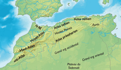
A map of northern
Algeria showing the location of the
554:
492:
212:as they dry. The largest of such lakes is the
478:
169:area consisting of undulating, steppe-like
485:
471:
578:Geography of Bordj Bou Arréridj Province
100:
18:Natural region in Algeria and NE Morocco
555:
369:Magdi Masgidi & Shafi Noor Islam,
466:
618:Geography of Oum El Bouaghi Province
126:
13:
538:
231:The main towns of the plateau are
14:
654:
412:
643:Geography of Tissemsilt Province
384:"Chott el-Hodna (lake, Algeria)"
63:
40:
598:Geography of Khenchela Province
593:Geography of El Bayadh Province
224:lies at the eastern end of the
201:The plateau area is covered by
603:Geography of Laghouat Province
398:
376:
362:
351:
1:
633:Geography of Tébessa Province
405:Les hautes plaines steppiques
345:
638:Geography of Tiaret Province
608:Geography of M'Sila Province
588:Geography of Djelfa Province
184:
157:direction from northeastern
95:1,000 m (3,000 ft)
7:
628:Geography of Sétif Province
623:Geography of Saïda Province
613:Geography of Naâma Province
583:Geography of Batna Province
563:Cultural regions of Algeria
494:Cultural regions of Algeria
328:
129:), also known in French as
10:
659:
573:Natural regions of Africa
536:
500:
386:. Encyclopædia Britannica
91:
77:
62:
46:Landscape of the eastern
39:
32:
23:
56:Oum el Bouaghi Province
544:
114:
542:
104:
568:Geography of Algeria
335:Geography of Algeria
443: /
545:
261:Bordj Bou Arreridj
233:Bordj Bou Arreridj
173:lying between the
115:
550:
549:
220:region, with the
214:Chott Ech Chergui
99:
98:
650:
487:
480:
473:
464:
463:
458:
457:
455:
454:
453:
448:
447:34.000°N 0.500°E
444:
441:
440:
439:
436:
407:
402:
396:
395:
393:
391:
380:
374:
366:
360:
355:
128:
121:("High Plains",
67:
44:
21:
20:
658:
657:
653:
652:
651:
649:
648:
647:
553:
552:
551:
546:
543:Flag of Algeria
534:
496:
491:
451:
449:
445:
442:
437:
434:
432:
430:
429:
415:
410:
403:
399:
389:
387:
382:
381:
377:
367:
363:
356:
352:
348:
331:
187:
171:alluvial plains
165:. It is a high
143:Atlas Mountains
141:located in the
73:
58:
35:
28:
19:
12:
11:
5:
656:
646:
645:
640:
635:
630:
625:
620:
615:
610:
605:
600:
595:
590:
585:
580:
575:
570:
565:
548:
547:
537:
535:
533:
532:
527:
522:
520:Hautes Plaines
517:
512:
507:
501:
498:
497:
490:
489:
482:
475:
467:
427:
426:
421:
414:
413:External links
411:
409:
408:
397:
375:
361:
349:
347:
344:
343:
342:
337:
330:
327:
319:
318:
301:Western part:
299:
282:Central part:
280:
277:Oum El Bouaghi
226:Hautes Plaines
222:Chott el Hodna
191:Hautes Plaines
186:
183:
155:west southwest
151:east northeast
139:natural region
131:Hauts Plateaux
119:Hautes Plaines
107:Hautes Plaines
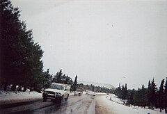
105:Winter in the
97:
96:
93:
89:
88:
79:
75:
74:
71:Hautes Plaines
68:
60:
59:
48:Hautes Plaines
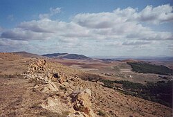
45:
37:
36:
34:Natural region
33:
30:
29:
26:Hautes Plaines
24:
17:
9:
6:
4:
3:
2:
655:
644:
641:
639:
636:
634:
631:
629:
626:
624:
621:
619:
616:
614:
611:
609:
606:
604:
601:
599:
596:
594:
591:
589:
586:
584:
581:
579:
576:
574:
571:
569:
566:
564:
561:
560:
558:
541:
531:
528:
526:
523:
521:
518:
516:
515:Constantinois
513:
511:
508:
506:
503:
502:
499:
495:
488:
483:
481:
476:
474:
469:
468:
465:
461:
459:
456:
452:34.000; 0.500
425:
422:
420:
417:
416:
406:
401:
385:
379:
373:
372:
365:
359:
354:
350:
341:
338:
336:
333:
332:
326:
324:
316:
312:
308:
304:
300:
297:
293:
289:
285:
281:
278:
274:
270:
266:
262:
258:
254:
253:
252:
250:
246:
242:
238:
234:
229:
227:
223:
219:
215:
211:
206:
204:
199:
197:
192:
182:
180:
179:Saharan Atlas
176:
172:
168:
164:
160:
156:
152:
148:
144:
140:
136:
132:
127:الهضاب العليا
124:
120:
112:
108:
103:
94:
90:
87:
83:
80:
76:
72:
66:
61:
57:
53:
49:
43:
38:
31:
27:
22:
16:
519:
460:
428:
400:
388:. Retrieved
378:
370:
364:
353:
320:
230:
225:
207:
200:
190:
188:
145:in northern
130:
118:
116:
111:Aïn Babouche
106:
70:
47:
25:
15:
450: /
557:Categories
346:References
317:provinces.
298:provinces.
296:Tissemsilt
210:salt flats
52:Ksar Sbahi
315:El Bayadh
269:Khenchela
185:Geography
92:Elevation
510:Algérois
329:See also
288:Laghouat
203:alluvial
181:ranges.
525:Kabylia
505:Oranais
435:34°00′N
390:21 June
273:Tébessa
167:plateau
161:to the
159:Morocco
147:Algeria
133:, is a
86:Morocco
84:and NE
82:Algeria
78:Country
438:0°30′E
323:barley
303:Tiaret
292:M’Sila
284:Djelfa
249:M'sila
245:Djelfa
241:Tiaret
196:Sahara
137:-like
135:steppe
123:Arabic
530:Aurès
340:Hodna
311:Naâma
307:Saida
265:Batna
257:Sétif
237:Sétif
218:Hodna
163:Aures
109:near
50:near
392:2013
313:and
294:and
275:and
247:and
189:The
177:and
175:Tell
117:The
559::
325:.
309:,
305:,
290:,
286:,
271:,
267:,
263:,
259:,
243:,
239:,
235:,
228:.
198:.
153:–
125::
54:,
486:e
479:t
472:v
394:.
279:.
113:.
Text is available under the Creative Commons Attribution-ShareAlike License. Additional terms may apply.


