19:
937:, 90%, or some three million acres (12,000 km²), have been drained for agriculture in the Minnesota River basin. Most of the prairies are now farm fields. Due to the quaternary and bedrock geology of the region, as well as the reduced precipitation in the region, groundwater resources are neither plentiful nor widely distributed, unlike most other areas of the state. Given these constraints, this rural area hosts a vast network of water pipelines which transports groundwater from the few localized areas with productive groundwater wells to much of the region's population.
1064:
184:. Precambrian bedrock has been mined for metallic minerals, including iron ore, on which the economy of Northeast Minnesota was built. Archaen granites and gneisses, and later limestones and sandstones, are quarried for structural stone and monuments. Glacial deposits are mined for aggregates, glacial till and lacustrine deposits formed the parent soil for the state's farmlands, and glacial lakes are the backbone of Minnesota's tourist industry. These economic assets have in turn dictated the
455:
4061:
1175:
586:
206:
745:. Topsoils are thin and poor and their parent soils derived from the rock beneath or nearby rather than from glacial till, which is sparse. Many of this region's lakes are located in depressions formed by the differential erosion of tilted layers of bedded rock of the Canadian Shield; the crevasses thereby formed have filled with water to create many of the thousands of lakes and swamps of the
946:
1151:
214:
761:. In the remainder of the region, lakes provide recreation, forests are managed for pulpwood, and the underlying bedrock is mined for valuable ores deposited in Precambrian times. While copper and nickel ores have been mined, the principal metallic mineral is iron. Three of Minnesota's four iron ranges are in the region, including the
1142:, all relics from recent glaciation. In the multitude of glacier-formed depressions are wetlands and many of the state's "10,000 lakes", which make the area prime vacation territory. The glacial deposits are a source of aggregate, and underneath the glacial till are high-quality granites which are quarried for buildings and monuments.
849:
1024:. Sansome attaches this moraine to her description of West-Central Minnesota, given its similarity in glacial features to that region. Under Sansome's classification (followed here), Southeastern Minnesota is generally coterminous with the Paleozoic Plateau Section of the Eastern Broadleaf Forest Province.
368:
thousands of meters further south. While the crustal tectonic plates continued their slow drift over the surface of the planet, meeting and separating in the successive collision and sundering of continents, the North
American craton remained stable. Although now free of folding and faulting caused by
818:
times this bedrock had been covered by clayey glacial drift scoured and transported south from sedimentary rocks in
Manitoba. The bottomland is undissected and essentially flat, but imperceptibly declines from about 400 meters at the southern beaches of Lake Agassiz to 335 meters along the Rainy
616:
by
Ojakangas and Matsch. These authorities generally agree on areal borders, but the regions as defined by Ojakangas and Matsch are more geographical in their approximations of areas of similar geology, while Sansome's divisions are more irregular in shape in order to include within a region all
1078:
of the St. Croix River (2) the basin of the
Mississippi River above its confluence with the Minnesota, (3) those parts of the Minnesota and Red River basins on the glacial uplands forming the divides of those two basins with that of the Mississippi, (4) the Owatonna Moraine atop a strip of land
672:
367:
The mountain-building and rifting events left areas of high relief above the low basin of the
Midcontinent rift. Over the next 1,100 million years, the uplands were worn down and the rift filled with sediments, forming rock ranging in thickness from several hundred meters near Lake Superior to
765:, which has supplied over 90% of the state's historic output, including most of the natural ores pure enough to be fed directly into furnaces. The state's iron mines have produced over three and a half billion metric tons of ore. While high-grade ores have now been exhausted, lower-grade
595:
Contemporary
Minnesota is much quieter geologically than in the past. Outcroppings of lava flows and magma intrusions are the only remaining traces of the volcanism that ended over 1,100 mya. Landlocked within the continent, the state is far from the seas that once covered it, and the
576:
than the sedimentary bedrock first encountered in many other regions, and glacial till is relatively sparse. While the effects of glacial erosion are clearly present and there are some areas of glacial till, older rocks and landforms remain unburied and exposed across much of the region.
1256:
remains as a picturesque and informative relic of River Warren Falls, and the limestone-over-sandstone construction is readily apparent in its small gorge. At St. Anthony Falls, the
Mississippi dropped 50 feet (15 m) over a limestone ledge; these waterfalls were used to drive the
375:
Five hundred fifty million years ago, the state was repeatedly inundated with water of a shallow sea that grew and receded through several cycles. The land mass of what is now North
America ran along the equator, and Minnesota had a tropical climate. Small marine creatures such as
958:
617:
areas of similar geology, with particular emphasis on the effects of recent glaciation. As glaciation and its residue has largely dictated regional surface geology and topography, Sansome's divisions are often coextensive with ecological provinces, sections, and subsections.
827:
of the land after recession of the last ice sheet. In the western part of the region in the Red River Valley, fine-grained glacial lake deposits and decayed organic materials up to 50 meters in depth form rich, well-textured, and moisture-retentive, yet well-drained soils
752:
In post-glacial times
Northeastern Minnesota was covered by forest broken only by these interconnected lakes and wetlands. Much of the area has been little changed by human activity, as there are substantial forest and wilderness preserves, most notably the
607:
and geological history, which in turn has affected
Minnesota's settlement patterns, human history, and economic development. These diverse geological regions can be classified several ways. The classification used here principally derives from Sansome's
699:
for its shape, this region shows the most visible evidence of the state's violent past. There are surface exposures of rocks first formed in volcanic activity some 2,700 mya during construction of the Archaen-Superior province, including Ely
285:
rock of today's state had already formed nearly a billion years earlier, but lay underneath the sea. Except for an area where islands appeared in what is now the northern part of the state, most of the region remained underwater.
2106:
While Sansome places the north bank of the Minnesota River in this region, this article follows Ojakangas and Matsch in assigning the lowlands along the north bank to Southwest Minnesota, and the uplands to Central Minnesota.
132:
The state's geologic history can be divided into three periods. The first period was a lengthy period of geologic instability from the origin of the planet until roughly 1,100 million years ago. During this time, the state's
1774:, at p. 201. The upland portions of the Red River watershed atop the moraine are different in character, with gravelly soil, lakes, and other glacial landforms, and therefore are assigned to the Central Minnesota region.
1110:
sediments, and underlying the eastern part of the region (and the southerly extension to Iowa) are the Late Precambrian Keweenawan volcanics of the Midcontinent Rift, overlaid by thousands of meters of sedimentary rocks.
4097:
1236:, a new waterfall was created where that river entered the much-lower River Warren. The new falls receded upstream on the Mississippi, migrating eight miles (13 km) over 9600 years to where
895:
divides the Minnesota and Missouri River valleys, and is a striking landform created by the bifurcation of different lobes of glacial advance. On the Minnesota side of the coteau is a feature known as
788:. In the northeast, the Glacial Lake Agassiz plain transitions into the forests of the Arrowhead. The region includes the lowland portions of the Red River watershed and the western half of the
819:
River. There is almost no relief, except for benches or beaches where Glacial Lake Agassiz stabilized for a time before it receded to a lower level. In contrast to the lakebed, these beaches
58:
bedrock that were formed in shallow tropical seas that covered southern and south-central Minnesota during that time. The geology of the southwest includes old rocks, the 3.6 billion year old
796:. In ecological terms, it includes the Northern Minnesota Peatlands of the Laurentian Mixed Forest, the Tallgrass Aspen Parklands, and the Red River Valley Section of the Prairie Parklands.
1047:. The last glaciation did not cover this region (halting at the Des Moines terminal lobe mentioned above), so there is no glacial drift to form subsoils, giving the region the name of the
470:
across the region. The ice retreated for the last time about 12,500 years ago. Melting glaciers formed many of the state's lakes and etched its river valleys. They also formed a number of
661:
564:, this region presents a widespread and highly dissected aspect absent from other parts of the state. Northeastern Minnesota was subject to glaciation and its effects, but its hard
549:
were much larger than today. The glaciers continued to retreat and the climate became warmer over the next few millennia; the giant creatures died out about 9,000 years ago.
289:
In Middle Precambrian time, about 2,000 mya, the land rose above the water. Heavy mineral deposits containing iron had collected on the shores of the receding sea to form the
4090:
1217:
metropolitan area. The region has the same types of glacial landforms as the remainder of Central Minnesota, but is distinguished by its bedrock valleys, both active and buried.
4083:
2559:
2303:
1657:
1346:
1039:
especially prevalent near the surface. It is highly dissected, and local tributaries of the Mississippi have cut deep valleys into the bedrock. It is an area of
2607:
Morey, G. B. (February 1999). "High-grade iron ore deposits of the Mesabi Range, Minnesota; product of a continental-scale Proterozoic ground-water flow system".
1729:
Morey, G. B. (February 1999). "High-grade iron ore deposits of the Mesabi Range, Minnesota; product of a continental-scale Proterozoic ground-water flow system".
3029:
458:
Northern hemisphere glaciation during the last ice ages. The creation of 3 to 4 km thick ice sheets caused a global sea level drop of about 120 m.
2484:
2396:
2293:
922:
is the site of historic Native American quarries of catlinite, which is more commonly known as "pipestone". Another notable outcrop in the region is the
861:
781:
420:
eras other land animals followed as the dinosaurs disappeared, but much of the physical evidence from this era has been scraped away or buried by recent
961:
Relief map of Southeastern Minnesota: Owatonna Moraine on extreme west; junction of the state's principal rivers in Central Minnesota in the north; the
552:
This glaciation has drastically remodeled most of Minnesota, and all but two of the state's regions are covered with deep layers of glacial till. The
2896:
1999:
993:
3240:
3061:
2351:
2268:
1586:
683:, once part of a single mountain range, were split when the center was engulfed by magma blistering up during the Midcontinent Rift, creating the
985:
4462:
3019:
2371:
2208:
2707:
1896:
2530:
1513:
4418:
1084:
653:
2920:
1170:
enters from northeast. East Central Minnesota is composed of the eastern half and all territory on the image north of the Mississippi.
3155:
2428:
2336:
1875:
1840:
1013:
966:
1945:
3071:
4408:
2754:
2636:
1432:
1378:
840:. At marginally higher elevations within these wetlands are areas of black spruce, tamarack, and other water-tolerant species.
2826:
3103:
3024:
514:, in the basin of Lake Superior, was dammed by a glacier; it drained down the ancient course of the Midcontinental Rift to the
4467:
3113:
2697:
1206:
1167:
754:
515:
246:
2509:
2238:
4428:
628:
is an irregularly-shaped region composed of the northeasternmost part of the state north of Lake Superior, the area around
3806:
2989:
2951:
2583:
2567:
1354:
2314:
1652:
649:
3056:
727:
and North Shore Volcanic Group, created by magma and lava which upwelled and hardened about 1,100 mya during the
4046:
3118:
2866:
2743:
2678:
2417:
1000:. Ojakangas and Matsch extend the region west past the moraine to a line running north from the Iowa border between
26:
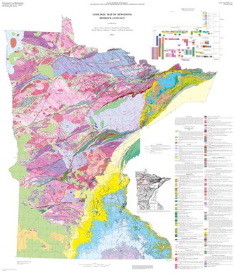
illustrating the main geologic regions of Minnesota. Igneous bodies lie across the northern half of the state, with
4390:
3343:
1220:
The valleys now hold three of Minnesota's largest rivers, which join here. The St. Croix joins the Mississippi at
665:
4166:
3796:
3250:
3145:
789:
708:
formations created about 1,900 mya that gave the area most of its mineral riches; and more recent intrusive
188:
and settlement patterns, and the trade and supply routes along the waterways, valleys and plains have become the
3478:
3091:
603:
While the state no longer has true mountain ranges or oceans, there is a fair amount of regional diversity in
4457:
4351:
3791:
3608:
3140:
3098:
3086:
2409:
1284:
899:, where wind speeds average 16 mph (26 km/h). This windy plateau has been developed for commercial
471:
2904:
2007:
1268:
lie deep beneath till deposited by the glaciers which created them, but can be traced in many places by the
910:
atop varying depths of glacial till. In the extreme southwest portion of the state, bedrock outcroppings of
891:, a much larger torrent that drained Lake Agassiz while outlets to the north were blocked by glaciers. The
687:. Lava from the rift formed dense volcanic rocks which sank, creating the Lake Superior basin, edged by the
4106:
4021:
3896:
3891:
3851:
3696:
3686:
3646:
3036:
1978:
1269:
449:
2925:. Minnesota Geological Survey, Educational Series 7. St. Paul: University of Minnesota. ISSN 0544-3083.
2774:
1637:
1403:
518:
and the Mississippi. When the glaciers receded, the lake was able to drain through the Great Lakes to the
4382:
4276:
3966:
3956:
3906:
3781:
3721:
3701:
3641:
3378:
3333:
3167:
3108:
3013:
3004:
1524:
479:
298:
189:
2355:
1590:
1193:
is that part of Central Minnesota near the junction of three of the state's great rivers. Included are
823:
from the south to the north and east at a gradient of approximately 1:5000; this rise resulted from the
596:
continental glacier has receded entirely from North America. Minnesota's landscape is a relatively flat
4026:
4001:
3936:
3926:
3871:
3856:
3831:
3826:
3811:
3746:
3731:
3726:
3671:
3631:
3413:
3368:
3280:
3076:
1198:
1017:
929:
Drier than most of the rest of the state, the region is a transition zone between the prairies and the
688:
738:
formed by this activity has been eroded but remains at or close to the surface over much of the area.
4436:
4398:
4316:
4281:
4075:
4006:
3986:
3976:
3931:
3886:
3816:
3786:
3776:
3771:
3756:
3751:
3736:
3716:
3676:
3656:
3568:
3213:
3198:
780:
is a vast plain in the bed of Glacial Lake Agassiz. This plain extends north and northwest from the
18:
4356:
4261:
4221:
4041:
4036:
4031:
4016:
4011:
3981:
3971:
3951:
3921:
3881:
3876:
3866:
3846:
3841:
3836:
3766:
3761:
3706:
3661:
3636:
3626:
3616:
3443:
3418:
3235:
1194:
746:
336:
161:
of successive layers of sediment from runoff and repeated incursions of the sea. In the third and
39:
2903:. National Resources Conservation Service, United States Department of Agriculture. Archived from
2216:
2182:
2006:. National Resources Conservation Service, United States Department of Agriculture. Archived from
926:, a Sioux Quartzite outcropping with numerous petroglyphs which may be up to 7000–9000 years old.
4321:
4311:
4306:
4286:
3991:
3961:
3861:
3741:
3711:
3651:
3621:
3458:
3393:
2944:
2719:
1908:
1528:
1233:
1043:
topography, with thin topsoils lying atop porous limestones, leading to formation of caverns and
815:
758:
704:, metamorphosed and highly folded volcanics once thought to be the oldest exposed rock on earth;
914:
are common, with less common interbedded outcrops of an associated metamorphosed mudstone named
4413:
4236:
4151:
3996:
3946:
3941:
3916:
3911:
3901:
3821:
3801:
3691:
3681:
3666:
3493:
3438:
3408:
3208:
3041:
2541:
2429:"Forest Sites, Bog Processes, and Peatland Types in the Glacial Lake Agassiz Region, Minnesota"
1532:
1214:
1202:
1009:
950:
934:
832:), which are ideal for agriculture. To the north and east, much of the land is poorly drained
600:; its highest and lowest points are separated by only 518 metres (1,699 ft) of elevation.
499:
4271:
4266:
4141:
3573:
3533:
3508:
3428:
3423:
3313:
3260:
3255:
3228:
3223:
3183:
3125:
3081:
3051:
2971:
2478:
1872:
Forest Sites, Bog Processes, and Peatland Types in the Glacial Lake Agassiz Region, Minnesota
1837:
Forest Sites, Bog Processes, and Peatland Types in the Glacial Lake Agassiz Region, Minnesota
467:
433:
278:
4361:
4326:
4206:
3588:
3563:
3558:
3553:
3548:
3543:
3498:
3483:
3468:
3270:
3203:
3188:
3130:
3066:
3009:
2999:
2994:
2981:
2789:
2616:
2443:
2273:
Geology of Ice Age National Scientific Reserve of Wisconsin, NPS Scientific Monograph No. 2
2213:
Geology of Ice Age National Scientific Reserve of Wisconsin, NPS Scientific Monograph No. 2
1738:
997:
919:
888:
857:
629:
519:
483:
309:
185:
181:
2876:
2031:
1870:
1835:
556:
of Southeastern Minnesota was untouched by the most recent glaciation. In the absence of
474:, which contributed to the state's topography and soils. Principal among these lakes was
388:
lived in the sea. The shells of the tiny animals sank to the bottom, and are preserved in
261:(million years ago) — roughly 80% the age of the planet. About 2,700 mya, the first
8:
4346:
4296:
4251:
4241:
4226:
4216:
4201:
4181:
4156:
4146:
4136:
3598:
3583:
3528:
3523:
3513:
3363:
3308:
3265:
3150:
1949:
1288:
1221:
923:
892:
865:
641:
511:
226:
2801:
2793:
2620:
2447:
1742:
1244:
in 1680. Due to its value as a power source, this waterfall determined the location of
1095:
and their waters were redirected through the lower Saint Louis River to Lake Superior.
482:
combined. Dammed by the northern ice sheet, this lake's immense flow found an outlet in
4366:
4341:
4246:
4186:
4161:
4131:
4121:
3518:
3488:
3473:
3388:
3245:
3193:
3135:
2937:
2855:
2658:
2513:
2459:
2242:
1229:
1005:
157:. In the second period, many layers of sedimentary rock were formed by deposition and
78:
35:
2640:
1382:
4301:
4256:
4196:
4171:
4126:
3593:
3578:
3538:
3448:
3433:
3403:
3398:
3303:
2862:
2838:
2739:
2693:
2674:
2413:
2390:
2287:
1296:
1295:
here contains the southernmost surface exposure of the Precambrian lava flows of the
1241:
1224:, Wisconsin. Upstream, the Mississippi is joined by the Minnesota River at historic
1155:
1115:
1096:
970:
824:
728:
495:
463:
408:
slid through the water, and fossil shark teeth have been found on the uplands of the
348:
238:
173:
over most of the state, and created the beds and valleys of modern lakes and rivers.
27:
1063:
4376:
4331:
4211:
4176:
4065:
3463:
3453:
3353:
3348:
3288:
3218:
2805:
2797:
2624:
2451:
1746:
989:
884:
811:
696:
222:
177:
142:
98:
74:
63:
1970:
557:
4403:
4336:
4291:
4191:
3338:
3328:
3293:
3160:
2493:
2081:
1879:
1844:
1809:
1784:
1661:
1624:
1292:
1253:
1252:, receded only a few hundred yards from one of the channels of the Mississippi.
1249:
1183:
1159:
1080:
1036:
911:
876:
853:
742:
701:
645:
637:
491:
437:
369:
274:
270:
242:
230:
218:
146:
94:
90:
66:
2304:"A Geophysical Investigation of the Ely Greenstone Belt in the Soudan Area, 4–5"
1796:
1573:
868:. The rough-appearing areas to the north and east are part of Central Minnesota.
3318:
2736:
Minnesota Underfoot: A Field Guide to the State's Outstanding Geologic Features
2628:
1750:
1237:
1075:
1048:
880:
724:
684:
680:
553:
546:
302:
234:
150:
110:
46:
in the northeast. In the southeast along the Mississippi River, up through the
31:
2591:
2378:. Anoka County Conservation District. Archived from the original on 2008-11-22
2154:
Ojakangas and Matsch attach the metropolitan area to Southeastern Minnesota.
1201:, and the region north of the Mississippi but south of an east-west line from
4451:
3298:
1265:
1225:
1135:
1092:
1088:
1052:
1021:
896:
657:
633:
344:
158:
59:
43:
2332:
1611:
1145:
1672:
of Southeast Minnesota) and Greenland and Labrador. Ojakangas and Matsch,
1163:
930:
793:
785:
762:
676:
561:
487:
475:
409:
294:
290:
170:
82:
23:
573:
3503:
1654:
A Geophysical Investigation of the Ely Greenstone Belt in the Soudan Area
1245:
1100:
848:
843:
732:
705:
569:
332:
134:
47:
2883:. Minnesota River Basin Data Center, Minnesota State University, Mankato
2038:. Minnesota River Basin Data Center, Minnesota State University, Mankato
1067:
Map of soils and sediments constituting Quaternary geology of Minnesota.
792:
watershed within the state, at approximately the level of Lake Agassiz’
3323:
2708:"Patterned peatlands near Ludlow Lookout, Northern Beltrami County, MN"
2566:. U.S. Geological Survey, Cascades Volcanic Observatory. Archived from
2463:
1897:"Patterned peatlands near Ludlow Lookout, Northern Beltrami County, MN"
1353:. U.S. Geological Survey, Cascades Volcanic Observatory. Archived from
1258:
1139:
1107:
1016:. This moraine runs south from the Twin Cities in the general area of
1012:, then encompassing the latter metropolis with a broad arc east to the
900:
503:
454:
429:
424:. The rock units that remain in Minnesota from this time period are of
305:
258:
166:
162:
129:, including their formation, development, distribution, and condition.
122:
70:
55:
4105:
2540:. Minnesota Geological Survey, University of Minnesota. Archived from
1174:
940:
3358:
2961:
2929:
1283:
from the last ice age. Along the eastern edge of the region are the
1210:
1044:
1032:
1028:
962:
915:
829:
804:
720:
713:
604:
597:
507:
401:
393:
389:
377:
356:
266:
138:
126:
2810:
2455:
1051:. As the topsoils are shallower and poorer than those to the west,
372:, the region continued to experience gradual subsidence and uplift.
30:
throughout the northwest and basalts and other igneous rocks of the
1770:
at p. 173, with image showing Herman Beach at Ojakanas and Matsch,
1123:
1119:
1091:
which once drained to the Mississippi before they were captured by
808:
766:
671:
538:
425:
417:
413:
340:
205:
114:
51:
2496:. Minnesota Geological Survey, University of Minnesota. 2003-12-01
1106:
The bedrock ranges in age from Archean granites to Upper Mesozoic
362:
355:. The rifting stopped before the land could become two separate
2275:. National Park Service. Archived from the original on 2008-02-08
1280:
1158:
enters from northwest and crosses diagonally to the southeast;
1114:
At the surface, the entire region is "Moraine terrain", with the
1001:
907:
800:
735:
716:
565:
534:
421:
262:
154:
86:
1150:
585:
478:, a massive lake with a volume rivaling that of all the present
351:
area, and south through eastern Minnesota down into what is now
2761:. Burke Museum of History and Culture, University of Washington
1439:. Burke Museum of History and Culture, University of Washington
1179:
1055:
rather than cash crops is the principal agricultural activity.
709:
526:
352:
282:
254:
253:
Minnesota contains some of the oldest rocks on Earth, granitic
225:
in the northwest, Central Minnesota's irregular landscape, the
957:
769:
continues to supply a large proportion of the nation's needs.
359:. About 100 million years later, the last volcano went quiet.
1668:, p. 3. Older rocks have since been found in Minnesota (the
1261:
that were the foundation for the city's 19th century growth.
1127:
1058:
1040:
405:
397:
385:
381:
317:
169:
eroded previous rock formations and deposited deep layers of
118:
1381:. Minnesota Dept. of Natural Resources. 2007. Archived from
945:
836:, often organized in rare and distinctive patterns known as
2715:
1904:
1131:
833:
530:
328:
324:
313:
1083:
south to the Iowa border, and (5) the upper valley of the
772:
620:
436:
at the bottom of the sequence of sedimentary rocks to the
1687:
Minnesota Underfoot: A Field Guide to Minnesota's Geology
1146:
East Central Minnesota: bedrock valleys and outwash plain
610:
Minnesota Underfoot: A Field Guide to Minnesota's Geology
542:
213:
2692:. Missoula, Montana: Mountain Press Publishing Company.
852:
Relief map of Southwestern Minnesota, transected by the
636:
basin southwest of Duluth, and much of the area east of
312:, Canada. These regions also showed the first signs of
2512:. University of Wisconsin at Eau Claire. Archived from
2241:. University of Wisconsin at Eau Claire. Archived from
2180:
2772:
2752:
2639:. Minnesota Dept. of Natural Resources. Archived from
2590:. The American Wind Energy Association. Archived from
1948:. The American Wind Energy Association. Archived from
1272:
in Minneapolis and lakes and dry valleys in St. Paul.
1154:
Relief map of the eastern part of Central Minnesota:
844:
Southwestern Minnesota: glacial river and glacial till
269:
began to rise up out of an ancient ocean, forming the
1430:
652:, the latter now occupied by the upper valley of the
1299:, providing a glimpse of Minnesota's volcanic past.
2406:
The Boundary Waters Canoe Area Wilderness Ecosystem
1248:. One tributary of the river coming from the west,
941:
Southeastern Minnesota: bluffs, caves and sinkholes
2854:
2657:
2837:. United States Geological Survey. Archived from
2831:Monographs of the United States Geological Survey
2669:Ojakangas, Richard W.; Matsch, Charles L (1982).
2510:"Interstate State Park, A Brief Geologic History"
2239:"Interstate State Park, A Brief Geologic History"
4449:
2483:: CS1 maint: bot: original URL status unknown (
2395:: CS1 maint: bot: original URL status unknown (
2292:: CS1 maint: bot: original URL status unknown (
1785:Northern Minnesota and Ontario Peatlands Section
1232:receded past the confluence of the much smaller
980:is separated from Southwestern Minnesota by the
741:The entire area is the raw southern edge of the
233:in the southwest, and the southeast's dissected
2753:Townsend, Catherine L.; Figge, John T. (2002).
2668:
2352:"Elevations and Distances in the United States"
1587:"Elevations and Distances in the United States"
864:; the triangular wedge in the southwest is the
466:starting about two million years ago, glaciers
363:Late Precambrian and Paleozoic sedimentary rock
85:, and is continuous across much of the western
2861:. Minneapolis: University of Minnesota Press.
2673:. Minneapolis: University of Minnesota Press.
2269:"Chapter 10: St. Croix Dalles Interstate Park"
2209:"Chapter 10: St. Croix Dalles Interstate Park"
1589:. U.S. Geological Survey. 2005. Archived from
1431:Townsend, Catherine L.; John T. Figge (2002).
1087:and the valley of its principal tributary the
887:. The Minnesota River lies in the bed of the
4091:
2945:
2782:Annual Review of Earth and Planetary Sciences
2615:(1). Society of Economic Geologists: 133–42.
2442:(4). Ecological Society of America: 327–374.
2313:. Minnesota Geological Survey. Archived from
784:, beyond Minnesota's borders into Canada and
498:. Eventually, the ice sheet melted, and the
2773:Van Schmus, W. R.; Hinze, W. J. (May 1985).
2494:"Mineral Potential and Geology of Minnesota"
2174:
400:from this era. Later, creatures resembling
2664:. Saint Paul: Minnesota Historical Society.
906:Between the river and the plateau are flat
537:were 14 feet (4.3 m) high at the
506:. As the lake drained away its bed became
502:gave Lake Agassiz a northern outlet toward
331:emerged from cracks along the edges of the
180:have been the historical foundation of the
4098:
4084:
2952:
2938:
2466:. Archived from the original on 2009-03-24
2426:
2403:
2230:
1570:Mineral Potential and Geology of Minnesota
1507:
1505:
1059:Central Minnesota: knob and kettle country
2809:
2687:
2376:Guide to Anoka County's Natural Resources
2372:"Geologic History of the Anoka Sandplain"
2337:Minnesota Department of Natural Resources
2187:Guide to Anoka County's Natural Resources
2183:"Geologic History of the Anoka Sandplain"
1373:
1371:
2354:. U.S. Geological Survey. Archived from
2301:
2026:
2024:
1704:The Boundary Waters Wilderness Ecosystem
1612:Ecological Land Classification Hierarchy
1173:
1149:
1062:
956:
944:
860:. To the northwest, the faint U-shaped
847:
670:
584:
580:
490:through the valleys now occupied by the
453:
308:from the center of the state north into
212:
204:
93:. Central Minnesota contains an ancient
17:
2897:"Wetlands Component Assessment Regions"
2733:
2637:"Natural History - Minnesota's Geology"
2528:
2215:. National Park Service. Archived from
2200:
1946:"U.S. Wind Energy Projects — Minnesota"
1689:, pp. 19, 30, 36; Ojakagas and Matsch,
1511:
1502:
1379:"Natural History - Minnesota's Geology"
1099:are the common characteristics of this
773:Northwestern Minnesota: glacial lakebed
621:Northeastern Minnesota: ancient bedrock
273:. This craton later assembled into the
145:and then modified by processes such as
73:sedimentary sequence that includes the
4450:
2959:
2852:
1368:
1275:North of the metropolitan area is the
200:
165:starting about 1.8 million years ago,
4463:Geology of the United States by state
4079:
2933:
2824:
2734:Sansome, Constance Jefferson (1983).
2606:
2266:
2206:
2115:at p. 109, with Ojakanas and Matsch,
2021:
2004:Wetlands Component Assessment Regions
1728:
1722:
755:Boundary Waters Canoe Area Wilderness
660:. This area is coextensive with the
644:. Excluded are parts of the beds of
339:extended from the lower peninsula of
195:
2922:Geologic History of Minnesota Rivers
2655:
2427:Heinselman, Miron L. (Autumn 1963).
1579:
1424:
347:, southwest through the lake to the
2857:The Streams and Rivers of Minnesota
2802:10.1146/annurev.ea.13.050185.002021
2584:"Minnesota Wind Energy Development"
2507:
2236:
13:
2738:. Stillwater, MN: Voyageur Press.
2491:Jirsa, Mark and Southwick, David.
2333:"Ecological Classification System"
2080:Ecological Classification System,
1808:Ecological Classification System,
1797:Tallgrass Aspen Parklands Province
1795:Ecological Classification System,
1783:Ecological Classification System,
1623:Ecological Classification System,
1610:Ecological Classification System,
1287:, a deep gorge cut by runoff from
933:. Once rich in wetlands known as
814:along the western border. By late
14:
4479:
2730:(Date of photograph: 1991-04-25.)
1625:Northern Superior Uplands Section
1213:border. It includes much of the
799:Bedrock in this region is mainly
662:Northern Superior Uplands Section
510:and a fertile plain. Similarly,
486:, which drained south across the
4059:
2132:, p. 9 ("Bedrock Geologic Map").
1178:Limestone over sandstone in the
265:rocks that would later underlie
209:Map of Minnesota bedrock by age.
2755:"Dance of the Giant Continents"
2564:America’s Volcanic Past: Places
2525:(Date of webpage = 2005-04-01.)
2298:(Date of webpage - 2005-04-01.)
2161:
2148:
2135:
2122:
2100:
2087:
2074:
2061:
2049:
1992:
1963:
1938:
1921:
1889:
1863:
1850:
1828:
1825:, p. 9 ("Bedrock Geology Map").
1815:
1802:
1789:
1777:
1757:
1709:
1696:
1679:
1645:
1630:
1617:
1604:
1562:
1549:
1489:
1476:
1433:"Dance of the Giant Continents"
1351:America’s Volcanic Past: Places
525:Giant animals roamed the area.
241:below its confluences with the
2892:(Date of webpage: 2004-11-15.)
2775:"The Midcontinent Rift System"
2688:Ojakangas, Richard W. (2009).
2603:Date of webpage: (2007-03-31.)
2579:(Date of webpage: 2003-01-26.)
2302:Chandler, Val W (2005-08-03).
1463:
1450:
1411:
1396:
1339:
1326:
1313:
1:
3369:Twin Cities metropolitan area
2690:Roadside Geology of Minnesota
2410:University of Minnesota Press
2367:(Date of webpage: 2005-04-29)
2181:Anoka Conservation District.
1302:
1285:Dalles of the St. Croix River
640:that runs between Duluth and
572:rocks were more resistant to
89:to the eastern slopes of the
4468:Natural history of Minnesota
4107:Geology of the United States
2531:"Quaternary Glacial Geology"
2508:Jol, Harry M. (2006-12-06).
1979:Minnesota Historical Society
1639:The Midcontinent Rift System
1514:"Quaternary Glacial Geology"
1405:The Midcontinent Rift System
984:, the eastern branch of the
949:Limestone bluffs cut by the
875:is in the watersheds of the
803:, with small areas of Lower
612:, but is also influenced by
450:Glacial history of Minnesota
320:grew in the shallow waters.
257:that formed some 3,600
7:
1525:Minnesota Geological Survey
443:
277:, which became part of the
221:in the northeast, the flat
10:
4484:
2916:(Date of map: April 2007.)
2853:Waters, Thomas F. (1977).
2827:"The Glacial Lake Agassiz"
2629:10.2113/gsecongeo.94.1.133
2404:Heinselman, Miron (1996).
2259:
1751:10.2113/gsecongeo.94.1.133
1660:November 28, 2007, at the
1574:Glacial cover in Minnesota
1027:The bedrock here is lower
1018:Minnesota State Highway 13
689:North Shore Volcanic Group
447:
281:. Much of the underlying
4427:
4389:
4375:
4114:
4055:
3607:
3377:
3279:
3176:
3020:Colleges and universities
2980:
2968:
2267:Black, Robert F. (2005).
2207:Black, Robert F. (2005).
2111:regional map at Sansome,
2082:Paleozoic Plateau Section
1766:regional map at Sansome,
249:in East Central Minnesota
4409:Northern Mariana Islands
2656:Nute, Grace Lee (1950).
2652:(Date of webpage: 2007.)
1810:Red River Valley Section
1693:, pp. 37–40, 50–55, 191.
1307:
1031:sedimentary rocks, with
747:Superior National Forest
337:Midcontinent Rift System
40:Midcontinent Rift System
3025:Congressional districts
2788:. Annual Reviews: 348.
2720:Microsoft Research Maps
1909:Microsoft Research Maps
1882:, pp. 354–61; Sansome,
1529:University of Minnesota
1291:into ancient bedrock.
1279:, a flat area of sandy
1240:first saw it and named
1234:Upper Mississippi River
1166:enters from the south;
1074:is composed of (1) the
1008:to the latitude of the
759:Voyageurs National Park
666:Laurentian Mixed Forest
323:Over 1,100 mya, a
3329:Minnesota River Valley
2919:Wright, W. E. (1990).
2825:Upham, Warren (1896).
2588:Wind Project Data Base
2529:Lusardi, B.A. (1997).
2237:Jol, Harry M. (2006).
2167:Ojakangas and Matsch,
2141:Ojakangas and Matsch,
1927:Ojakangas and Matsch,
1715:Ojakangas and Matsch,
1555:Ojakangas and Matsch,
1512:Lusardi, B.A. (1997).
1495:Ojakangas and Matsch,
1482:Ojakangas and Matsch,
1469:Ojakangas and Matsch,
1456:Ojakangas and Matsch,
1417:Ojakangas and Matsch,
1332:Ojakangas and Matsch,
1319:Ojakangas and Matsch,
1191:East Central Minnesota
1186:
1171:
1068:
978:Southeastern Minnesota
974:
954:
873:Southwestern Minnesota
869:
778:Northwestern Minnesota
692:
656:and its tributary the
626:Northeastern Minnesota
592:
468:expanded and retreated
459:
250:
210:
190:state's transportation
141:and the deposition of
137:bedrock was formed by
102:
4109:by political division
3314:Dissected Till Plains
2538:Minnesota at a Glance
2436:Ecological Monographs
2311:Open File Report 05-1
1568:Jirsa and Southwick,
1521:Minnesota at a Glance
1177:
1153:
1079:running from western
1066:
960:
948:
856:in the valley of the
851:
674:
588:
581:Contemporary features
457:
434:Mount Simon Sandstone
343:north to the current
279:North American craton
217:Shaded relief image:
216:
208:
50:, canyons carve into
21:
4458:Geology of Minnesota
4066:Minnesota portal
3062:Historical Landmarks
998:Wisconsin glaciation
920:Pipestone, Minnesota
889:glacial River Warren
858:glacial River Warren
691:along the lakeshore.
630:Jay Cooke State Park
541:and weighed 10
520:Saint Lawrence River
484:glacial River Warren
310:Northwestern Ontario
107:geology of Minnesota
4419:U.S. Virgin Islands
3479:Inver Grove Heights
3309:Coteau des Prairies
3156:Tourist attractions
3072:Indian reservations
2794:1985AREPS..13..345V
2671:Minnesota's Geology
2660:Rainy River Country
2643:on October 10, 2006
2621:1999EcGeo..94..133M
2448:1963EcoM...33..327H
2169:Minnesota’s Geology
2156:Minnesota’s Geology
2143:Minnesota’s Geology
2130:Minnesota Underfoot
2117:Minnesota’s Geology
2113:Minnesota Underfoot
2095:Minnesota Underfoot
2069:Minnesota Underfoot
2056:Minnesota’s Geology
1975:Jeffers Petroglyphs
1933:Minnesota Underfoot
1931:, p. 223; Sansome,
1929:Minnesota’s Geology
1884:Minnesota Underfoot
1858:Minnesota Underfoot
1823:Minnesota Underfoot
1772:Minnesota’s Geology
1768:Minnesota Underfoot
1743:1999EcGeo..94..133M
1717:Minnesota’s Geology
1691:Minnesota's Geology
1674:Minnesota's Geology
1666:Rainy River Country
1636:Van Schmus et al.,
1557:Minnesota’s Geology
1497:Minnesota’s Geology
1484:Minnesota's Geology
1471:Minnesota’s Geology
1458:Minnesota’s Geology
1419:Minnesota’s Geology
1402:Van Schmus et al.,
1385:on October 10, 2006
1334:Minnesota's Geology
1321:Minnesota's Geology
1289:Glacial Lake Duluth
924:Jeffers Petroglyphs
893:Coteau des Prairies
866:Coteau des Prairies
642:International Falls
614:Minnesota's Geology
512:Glacial Lake Duluth
227:Coteau des Prairies
201:Precambrian bedrock
1878:2007-07-23 at the
1843:2007-07-23 at the
1719:, pp. 185, 190–91.
1230:River Warren Falls
1187:
1172:
1069:
975:
971:Mississippi Rivers
955:
870:
838:patterned peatland
693:
593:
496:Mississippi Rivers
460:
251:
211:
196:Geological history
178:geologic resources
163:most recent period
103:
79:Niobrara Formation
69:, overlain by the
36:Beaver Bay Complex
4445:
4444:
4073:
4072:
3807:Lake of the Woods
3104:Political parties
2759:Northwest Origins
2712:Aerial photograph
2699:978-0-87842-562-4
1901:Aerial photograph
1664:, pp. 4–5; Nute,
1437:Northwest Origins
1297:Midcontinent Rift
1242:St. Anthony Falls
1189:The subregion of
1162:in the valley of
1156:Mississippi River
1116:glacial landforms
1097:Glacial landforms
1085:Saint Louis River
1072:Central Minnesota
965:border along the
953:in Olmsted County
862:Big Stone Moraine
825:isostatic rebound
812:sedimentary rocks
782:Big Stone Moraine
729:Midcontinent Rift
654:Saint Louis River
529:were the size of
464:Quaternary Period
239:Mississippi River
4475:
4429:Outlying islands
4383:Washington, D.C.
4377:Federal district
4100:
4093:
4086:
4077:
4076:
4064:
4063:
4062:
3381:pop. over 25,000
3354:Red River Valley
3114:School districts
3087:Local government
2954:
2947:
2940:
2931:
2930:
2915:
2913:
2912:
2891:
2889:
2888:
2872:
2860:
2849:
2847:
2846:
2821:
2819:
2818:
2813:
2779:
2769:
2767:
2766:
2749:
2729:
2727:
2726:
2703:
2684:
2665:
2663:
2651:
2649:
2648:
2632:
2609:Economic Geology
2602:
2600:
2599:
2578:
2576:
2575:
2555:
2553:
2552:
2546:
2535:
2524:
2522:
2521:
2504:
2502:
2501:
2488:
2482:
2474:
2472:
2471:
2433:
2423:
2400:
2394:
2386:
2384:
2383:
2366:
2364:
2363:
2347:
2345:
2344:
2328:
2326:
2325:
2319:
2308:
2297:
2291:
2283:
2281:
2280:
2254:
2253:
2251:
2250:
2234:
2228:
2227:
2225:
2224:
2204:
2198:
2197:
2195:
2194:
2178:
2172:
2165:
2159:
2152:
2146:
2139:
2133:
2126:
2120:
2104:
2098:
2091:
2085:
2078:
2072:
2065:
2059:
2053:
2047:
2046:
2044:
2043:
2028:
2019:
2018:
2016:
2015:
1996:
1990:
1989:
1987:
1985:
1967:
1961:
1960:
1958:
1957:
1952:on April 5, 2008
1942:
1936:
1925:
1919:
1918:
1916:
1915:
1893:
1887:
1867:
1861:
1854:
1848:
1832:
1826:
1819:
1813:
1806:
1800:
1793:
1787:
1781:
1775:
1761:
1755:
1754:
1731:Economic Geology
1726:
1720:
1713:
1707:
1700:
1694:
1683:
1677:
1649:
1643:
1634:
1628:
1621:
1615:
1608:
1602:
1601:
1599:
1598:
1583:
1577:
1566:
1560:
1553:
1547:
1546:
1544:
1543:
1537:
1531:. Archived from
1518:
1509:
1500:
1493:
1487:
1480:
1474:
1467:
1461:
1454:
1448:
1447:
1445:
1444:
1428:
1422:
1415:
1409:
1400:
1394:
1393:
1391:
1390:
1375:
1366:
1365:
1363:
1362:
1343:
1337:
1330:
1324:
1317:
990:terminal moraine
982:Owatonna Moraine
935:prairie potholes
885:Des Moines River
590:Geologic regions
558:glacial scouring
472:proglacial lakes
223:Red River Valley
143:sedimentary rock
99:Penokean orogeny
97:system from the
75:Dakota Sandstone
64:Paleoproterozoic
4483:
4482:
4478:
4477:
4476:
4474:
4473:
4472:
4448:
4447:
4446:
4441:
4423:
4385:
4371:
4110:
4104:
4074:
4069:
4060:
4058:
4051:
4047:Yellow Medicine
3603:
3414:Brooklyn Center
3380:
3373:
3339:Northwest Angle
3294:Boundary Waters
3275:
3172:
3161:Mall of America
2976:
2964:
2958:
2928:
2910:
2908:
2895:
2886:
2884:
2875:
2869:
2844:
2842:
2816:
2814:
2777:
2764:
2762:
2746:
2724:
2722:
2706:
2700:
2681:
2646:
2644:
2635:
2597:
2595:
2582:
2573:
2571:
2558:
2550:
2548:
2544:
2533:
2519:
2517:
2499:
2497:
2492:
2476:
2475:
2469:
2467:
2456:10.2307/1950750
2431:
2420:
2408:. Minneapolis:
2388:
2387:
2381:
2379:
2370:
2361:
2359:
2350:
2342:
2340:
2331:
2323:
2321:
2317:
2306:
2285:
2284:
2278:
2276:
2262:
2257:
2248:
2246:
2235:
2231:
2222:
2220:
2205:
2201:
2192:
2190:
2179:
2175:
2166:
2162:
2158:, p. 232 (map).
2153:
2149:
2140:
2136:
2127:
2123:
2105:
2101:
2092:
2088:
2079:
2075:
2066:
2062:
2058:, p. 222 (map).
2054:
2050:
2041:
2039:
2030:
2029:
2022:
2013:
2011:
1998:
1997:
1993:
1983:
1981:
1969:
1968:
1964:
1955:
1953:
1944:
1943:
1939:
1926:
1922:
1913:
1911:
1895:
1894:
1890:
1880:Wayback Machine
1868:
1864:
1855:
1851:
1845:Wayback Machine
1833:
1829:
1820:
1816:
1807:
1803:
1794:
1790:
1782:
1778:
1762:
1758:
1727:
1723:
1714:
1710:
1701:
1697:
1684:
1680:
1662:Wayback Machine
1650:
1646:
1635:
1631:
1622:
1618:
1609:
1605:
1596:
1594:
1585:
1584:
1580:
1567:
1563:
1554:
1550:
1541:
1539:
1535:
1516:
1510:
1503:
1494:
1490:
1481:
1477:
1468:
1464:
1455:
1451:
1442:
1440:
1429:
1425:
1416:
1412:
1408:, pp. 345, 349.
1401:
1397:
1388:
1386:
1377:
1376:
1369:
1360:
1358:
1345:
1344:
1340:
1331:
1327:
1318:
1314:
1310:
1305:
1293:Interstate Park
1277:Anoka Sandplain
1254:Minnehaha Falls
1250:Minnehaha Creek
1207:St. Croix River
1199:Hennepin County
1184:Minnehaha Creek
1160:Minnesota River
1148:
1081:Hennepin County
1061:
1014:St. Croix River
994:Des Moines lobe
943:
912:Sioux Quartzite
877:Minnesota River
854:Minnesota River
846:
775:
743:Canadian Shield
681:Gunflint Ranges
638:U.S. Highway 53
623:
591:
583:
574:glacial erosion
516:St. Croix River
452:
446:
438:Maquoketa Group
370:plate tectonics
365:
275:Canadian shield
271:Superior craton
231:Minnesota River
219:Superior Upland
203:
198:
186:state's history
182:state's economy
91:Rocky Mountains
67:Sioux Quartzite
12:
11:
5:
4481:
4471:
4470:
4465:
4460:
4443:
4442:
4440:
4439:
4437:Howland Island
4433:
4431:
4425:
4424:
4422:
4421:
4416:
4411:
4406:
4401:
4399:American Samoa
4395:
4393:
4387:
4386:
4381:
4379:
4373:
4372:
4370:
4369:
4364:
4359:
4354:
4349:
4344:
4339:
4334:
4329:
4324:
4319:
4317:South Carolina
4314:
4309:
4304:
4299:
4294:
4289:
4284:
4282:North Carolina
4279:
4274:
4269:
4264:
4259:
4254:
4249:
4244:
4239:
4234:
4229:
4224:
4219:
4214:
4209:
4204:
4199:
4194:
4189:
4184:
4179:
4174:
4169:
4164:
4159:
4154:
4149:
4144:
4139:
4134:
4129:
4124:
4118:
4116:
4112:
4111:
4103:
4102:
4095:
4088:
4080:
4071:
4070:
4056:
4053:
4052:
4050:
4049:
4044:
4039:
4034:
4029:
4024:
4019:
4014:
4009:
4004:
3999:
3994:
3989:
3984:
3979:
3974:
3969:
3964:
3959:
3954:
3949:
3944:
3939:
3934:
3929:
3924:
3919:
3914:
3909:
3904:
3899:
3894:
3889:
3884:
3879:
3874:
3869:
3864:
3859:
3854:
3849:
3844:
3839:
3834:
3829:
3824:
3819:
3814:
3809:
3804:
3799:
3794:
3789:
3784:
3779:
3774:
3769:
3764:
3759:
3754:
3749:
3744:
3739:
3734:
3729:
3724:
3719:
3714:
3709:
3704:
3699:
3694:
3689:
3684:
3679:
3674:
3669:
3664:
3659:
3654:
3649:
3644:
3639:
3634:
3629:
3624:
3619:
3613:
3611:
3605:
3604:
3602:
3601:
3596:
3591:
3586:
3581:
3576:
3571:
3569:St. Louis Park
3566:
3561:
3556:
3551:
3546:
3541:
3536:
3531:
3526:
3521:
3516:
3511:
3506:
3501:
3496:
3491:
3486:
3481:
3476:
3471:
3466:
3461:
3456:
3451:
3446:
3441:
3436:
3431:
3426:
3421:
3416:
3411:
3406:
3401:
3396:
3391:
3385:
3383:
3379:Largest cities
3375:
3374:
3372:
3371:
3366:
3361:
3356:
3351:
3346:
3341:
3336:
3331:
3326:
3321:
3319:Driftless Area
3316:
3311:
3306:
3301:
3296:
3291:
3285:
3283:
3277:
3276:
3274:
3273:
3268:
3263:
3258:
3253:
3248:
3243:
3238:
3233:
3232:
3231:
3226:
3216:
3211:
3206:
3201:
3196:
3191:
3186:
3180:
3178:
3174:
3173:
3171:
3170:
3168:Transportation
3165:
3164:
3163:
3153:
3148:
3143:
3138:
3133:
3128:
3123:
3122:
3121:
3111:
3106:
3101:
3096:
3095:
3094:
3084:
3079:
3074:
3069:
3064:
3059:
3054:
3049:
3044:
3039:
3034:
3033:
3032:
3022:
3017:
3014:Climate change
3007:
3002:
3000:Biking/Cycling
2997:
2992:
2986:
2984:
2978:
2977:
2969:
2966:
2965:
2957:
2956:
2949:
2942:
2934:
2927:
2926:
2917:
2893:
2873:
2867:
2850:
2822:
2770:
2750:
2744:
2731:
2704:
2698:
2685:
2679:
2666:
2653:
2633:
2604:
2580:
2556:
2526:
2505:
2489:
2424:
2418:
2401:
2368:
2348:
2329:
2299:
2263:
2261:
2258:
2256:
2255:
2229:
2199:
2189:. Anoka County
2173:
2160:
2147:
2134:
2121:
2099:
2086:
2073:
2060:
2048:
2020:
1991:
1962:
1937:
1920:
1888:
1862:
1860:, p. 174, 181.
1849:
1827:
1814:
1801:
1788:
1776:
1756:
1721:
1708:
1695:
1678:
1644:
1629:
1616:
1603:
1578:
1561:
1548:
1501:
1499:, pp. 97, 108.
1488:
1475:
1462:
1449:
1423:
1410:
1395:
1367:
1338:
1325:
1311:
1309:
1306:
1304:
1301:
1270:Chain of Lakes
1266:tunnel valleys
1264:Other bedrock
1238:Louis Hennepin
1147:
1144:
1136:outwash plains
1103:-like region.
1076:drainage basin
1060:
1057:
1049:Driftless area
996:from the last
942:
939:
881:Missouri River
845:
842:
774:
771:
725:Duluth Complex
685:Duluth Complex
622:
619:
589:
582:
579:
554:driftless area
445:
442:
432:age, from the
412:. During the
364:
361:
235:Driftless Area
202:
199:
197:
194:
109:comprises the
32:Duluth Complex
9:
6:
4:
3:
2:
4480:
4469:
4466:
4464:
4461:
4459:
4456:
4455:
4453:
4438:
4435:
4434:
4432:
4430:
4426:
4420:
4417:
4415:
4412:
4410:
4407:
4405:
4402:
4400:
4397:
4396:
4394:
4392:
4388:
4384:
4380:
4378:
4374:
4368:
4365:
4363:
4360:
4358:
4357:West Virginia
4355:
4353:
4350:
4348:
4345:
4343:
4340:
4338:
4335:
4333:
4330:
4328:
4325:
4323:
4320:
4318:
4315:
4313:
4310:
4308:
4305:
4303:
4300:
4298:
4295:
4293:
4290:
4288:
4285:
4283:
4280:
4278:
4275:
4273:
4270:
4268:
4265:
4263:
4262:New Hampshire
4260:
4258:
4255:
4253:
4250:
4248:
4245:
4243:
4240:
4238:
4235:
4233:
4230:
4228:
4225:
4223:
4222:Massachusetts
4220:
4218:
4215:
4213:
4210:
4208:
4205:
4203:
4200:
4198:
4195:
4193:
4190:
4188:
4185:
4183:
4180:
4178:
4175:
4173:
4170:
4168:
4165:
4163:
4160:
4158:
4155:
4153:
4150:
4148:
4145:
4143:
4140:
4138:
4135:
4133:
4130:
4128:
4125:
4123:
4120:
4119:
4117:
4113:
4108:
4101:
4096:
4094:
4089:
4087:
4082:
4081:
4078:
4068:
4067:
4054:
4048:
4045:
4043:
4040:
4038:
4035:
4033:
4030:
4028:
4025:
4023:
4020:
4018:
4015:
4013:
4010:
4008:
4005:
4003:
4000:
3998:
3995:
3993:
3990:
3988:
3985:
3983:
3980:
3978:
3975:
3973:
3970:
3968:
3965:
3963:
3960:
3958:
3955:
3953:
3950:
3948:
3945:
3943:
3940:
3938:
3935:
3933:
3930:
3928:
3925:
3923:
3920:
3918:
3915:
3913:
3910:
3908:
3905:
3903:
3900:
3898:
3895:
3893:
3890:
3888:
3885:
3883:
3880:
3878:
3875:
3873:
3870:
3868:
3865:
3863:
3860:
3858:
3855:
3853:
3850:
3848:
3845:
3843:
3840:
3838:
3835:
3833:
3830:
3828:
3825:
3823:
3820:
3818:
3815:
3813:
3810:
3808:
3805:
3803:
3800:
3798:
3797:Lac qui Parle
3795:
3793:
3790:
3788:
3785:
3783:
3780:
3778:
3775:
3773:
3770:
3768:
3765:
3763:
3760:
3758:
3755:
3753:
3750:
3748:
3745:
3743:
3740:
3738:
3735:
3733:
3730:
3728:
3725:
3723:
3720:
3718:
3715:
3713:
3710:
3708:
3705:
3703:
3700:
3698:
3695:
3693:
3690:
3688:
3685:
3683:
3680:
3678:
3675:
3673:
3670:
3668:
3665:
3663:
3660:
3658:
3655:
3653:
3650:
3648:
3645:
3643:
3640:
3638:
3635:
3633:
3630:
3628:
3625:
3623:
3620:
3618:
3615:
3614:
3612:
3610:
3606:
3600:
3597:
3595:
3592:
3590:
3587:
3585:
3582:
3580:
3577:
3575:
3572:
3570:
3567:
3565:
3562:
3560:
3557:
3555:
3552:
3550:
3547:
3545:
3542:
3540:
3537:
3535:
3532:
3530:
3527:
3525:
3522:
3520:
3517:
3515:
3512:
3510:
3507:
3505:
3502:
3500:
3497:
3495:
3492:
3490:
3487:
3485:
3482:
3480:
3477:
3475:
3472:
3470:
3467:
3465:
3462:
3460:
3457:
3455:
3452:
3450:
3447:
3445:
3444:Cottage Grove
3442:
3440:
3437:
3435:
3432:
3430:
3427:
3425:
3422:
3420:
3419:Brooklyn Park
3417:
3415:
3412:
3410:
3407:
3405:
3402:
3400:
3397:
3395:
3392:
3390:
3387:
3386:
3384:
3382:
3376:
3370:
3367:
3365:
3362:
3360:
3357:
3355:
3352:
3350:
3347:
3345:
3342:
3340:
3337:
3335:
3332:
3330:
3327:
3325:
3322:
3320:
3317:
3315:
3312:
3310:
3307:
3305:
3302:
3300:
3299:Buffalo Ridge
3297:
3295:
3292:
3290:
3287:
3286:
3284:
3282:
3278:
3272:
3269:
3267:
3264:
3262:
3259:
3257:
3254:
3252:
3249:
3247:
3244:
3242:
3241:Movies and TV
3239:
3237:
3234:
3230:
3227:
3225:
3222:
3221:
3220:
3217:
3215:
3212:
3210:
3207:
3205:
3202:
3200:
3197:
3195:
3192:
3190:
3187:
3185:
3182:
3181:
3179:
3175:
3169:
3166:
3162:
3159:
3158:
3157:
3154:
3152:
3149:
3147:
3144:
3142:
3139:
3137:
3134:
3132:
3129:
3127:
3124:
3120:
3117:
3116:
3115:
3112:
3110:
3107:
3105:
3102:
3100:
3097:
3093:
3090:
3089:
3088:
3085:
3083:
3080:
3078:
3075:
3073:
3070:
3068:
3065:
3063:
3060:
3058:
3055:
3053:
3050:
3048:
3045:
3043:
3040:
3038:
3035:
3031:
3028:
3027:
3026:
3023:
3021:
3018:
3015:
3011:
3008:
3006:
3003:
3001:
2998:
2996:
2993:
2991:
2988:
2987:
2985:
2983:
2979:
2974:
2973:
2967:
2963:
2955:
2950:
2948:
2943:
2941:
2936:
2935:
2932:
2924:
2923:
2918:
2907:on 2007-11-30
2906:
2902:
2898:
2894:
2882:
2878:
2874:
2870:
2868:0-8166-0821-0
2864:
2859:
2858:
2851:
2841:on 2009-05-23
2840:
2836:
2832:
2828:
2823:
2812:
2807:
2803:
2799:
2795:
2791:
2787:
2783:
2776:
2771:
2760:
2756:
2751:
2747:
2745:0-89658-036-9
2741:
2737:
2732:
2721:
2717:
2713:
2709:
2705:
2701:
2695:
2691:
2686:
2682:
2680:0-8166-0953-5
2676:
2672:
2667:
2662:
2661:
2654:
2642:
2638:
2634:
2630:
2626:
2622:
2618:
2614:
2610:
2605:
2594:on 2007-09-27
2593:
2589:
2585:
2581:
2570:on 2009-01-10
2569:
2565:
2561:
2557:
2547:on 2007-02-03
2543:
2539:
2532:
2527:
2516:on 2012-12-15
2515:
2511:
2506:
2495:
2490:
2486:
2480:
2465:
2461:
2457:
2453:
2449:
2445:
2441:
2437:
2430:
2425:
2421:
2419:0-8166-2804-1
2415:
2411:
2407:
2402:
2398:
2392:
2377:
2373:
2369:
2358:on 2008-06-01
2357:
2353:
2349:
2338:
2334:
2330:
2320:on 2007-11-28
2316:
2312:
2305:
2300:
2295:
2289:
2274:
2270:
2265:
2264:
2245:on 2012-12-15
2244:
2240:
2233:
2219:on 2007-05-13
2218:
2214:
2210:
2203:
2188:
2184:
2177:
2170:
2164:
2157:
2151:
2144:
2138:
2131:
2125:
2118:
2114:
2110:
2103:
2096:
2090:
2083:
2077:
2070:
2064:
2057:
2052:
2037:
2033:
2027:
2025:
2010:on 2007-03-14
2009:
2005:
2001:
1995:
1980:
1976:
1972:
1966:
1951:
1947:
1941:
1935:, pp. 110–11.
1934:
1930:
1924:
1910:
1906:
1902:
1898:
1892:
1886:, pp. 191–93.
1885:
1881:
1877:
1874:
1873:
1866:
1859:
1853:
1846:
1842:
1839:
1838:
1831:
1824:
1818:
1811:
1805:
1798:
1792:
1786:
1780:
1773:
1769:
1765:
1760:
1752:
1748:
1744:
1740:
1737:(1): 133–42.
1736:
1732:
1725:
1718:
1712:
1705:
1699:
1692:
1688:
1682:
1675:
1671:
1670:Morton gneiss
1667:
1663:
1659:
1656:
1655:
1648:
1641:
1640:
1633:
1626:
1620:
1613:
1607:
1593:on 2008-06-01
1592:
1588:
1582:
1575:
1571:
1565:
1559:, pp. 116–18.
1558:
1552:
1538:on 2007-02-03
1534:
1530:
1526:
1522:
1515:
1508:
1506:
1498:
1492:
1485:
1479:
1472:
1466:
1459:
1453:
1438:
1434:
1427:
1420:
1414:
1407:
1406:
1399:
1384:
1380:
1374:
1372:
1357:on 2009-01-10
1356:
1352:
1348:
1342:
1335:
1329:
1322:
1316:
1312:
1300:
1298:
1294:
1290:
1286:
1282:
1278:
1273:
1271:
1267:
1262:
1260:
1255:
1251:
1247:
1243:
1239:
1235:
1231:
1227:
1226:Fort Snelling
1223:
1218:
1216:
1212:
1208:
1204:
1200:
1196:
1195:Dakota County
1192:
1185:
1181:
1176:
1169:
1165:
1161:
1157:
1152:
1143:
1141:
1137:
1133:
1129:
1125:
1121:
1117:
1112:
1109:
1104:
1102:
1098:
1094:
1093:stream piracy
1090:
1089:Cloquet River
1086:
1082:
1077:
1073:
1065:
1056:
1054:
1053:dairy farming
1050:
1046:
1042:
1038:
1034:
1030:
1025:
1023:
1022:Interstate 35
1019:
1015:
1011:
1007:
1003:
999:
995:
991:
987:
986:Bemis Moraine
983:
979:
972:
968:
964:
959:
952:
947:
938:
936:
932:
927:
925:
921:
917:
913:
909:
904:
902:
898:
897:Buffalo Ridge
894:
890:
886:
882:
878:
874:
867:
863:
859:
855:
850:
841:
839:
835:
831:
826:
822:
817:
813:
810:
806:
802:
797:
795:
791:
787:
783:
779:
770:
768:
764:
760:
756:
750:
748:
744:
739:
737:
734:
730:
726:
722:
718:
715:
711:
707:
703:
698:
695:Known as the
690:
686:
682:
678:
673:
669:
667:
663:
659:
655:
651:
647:
646:glacial lakes
643:
639:
635:
634:Nemadji River
631:
627:
618:
615:
611:
606:
601:
599:
587:
578:
575:
571:
567:
563:
559:
555:
550:
548:
544:
540:
536:
532:
528:
523:
521:
517:
513:
509:
505:
501:
497:
493:
489:
485:
481:
477:
473:
469:
465:
456:
451:
441:
439:
435:
431:
427:
423:
419:
415:
411:
407:
403:
399:
395:
391:
387:
383:
379:
373:
371:
360:
358:
354:
350:
346:
345:Lake Superior
342:
338:
334:
330:
326:
321:
319:
315:
311:
307:
304:
300:
296:
292:
287:
284:
280:
276:
272:
268:
264:
260:
256:
248:
244:
240:
236:
232:
228:
224:
220:
215:
207:
193:
191:
187:
183:
179:
174:
172:
168:
164:
160:
159:lithification
156:
152:
148:
144:
140:
136:
130:
128:
124:
120:
116:
112:
108:
100:
96:
92:
88:
84:
80:
76:
72:
68:
65:
61:
60:Morton Gneiss
57:
53:
49:
45:
44:Lake Superior
41:
37:
33:
29:
25:
20:
16:
4414:Puerto Rico
4322:South Dakota
4312:Rhode Island
4307:Pennsylvania
4287:North Dakota
4231:
4057:
3459:Eden Prairie
3394:Apple Valley
3214:Homelessness
3199:Demographics
3119:High schools
3046:
2970:
2921:
2909:. Retrieved
2905:the original
2900:
2885:. Retrieved
2880:
2856:
2843:. Retrieved
2839:the original
2834:
2830:
2815:. Retrieved
2785:
2781:
2763:. Retrieved
2758:
2735:
2723:. Retrieved
2711:
2689:
2670:
2659:
2645:. Retrieved
2641:the original
2612:
2608:
2596:. Retrieved
2592:the original
2587:
2572:. Retrieved
2568:the original
2563:
2549:. Retrieved
2542:the original
2537:
2518:. Retrieved
2514:the original
2498:. Retrieved
2479:cite journal
2468:. Retrieved
2439:
2435:
2405:
2380:. Retrieved
2375:
2360:. Retrieved
2356:the original
2341:. Retrieved
2322:. Retrieved
2315:the original
2310:
2277:. Retrieved
2272:
2247:. Retrieved
2243:the original
2232:
2221:. Retrieved
2217:the original
2212:
2202:
2191:. Retrieved
2186:
2176:
2168:
2163:
2155:
2150:
2142:
2137:
2129:
2124:
2119:, at p. 222.
2116:
2112:
2108:
2102:
2097:, p. 129-31.
2094:
2089:
2076:
2068:
2063:
2055:
2051:
2040:. Retrieved
2035:
2012:. Retrieved
2008:the original
2003:
1994:
1982:. Retrieved
1974:
1965:
1954:. Retrieved
1950:the original
1940:
1932:
1928:
1923:
1912:. Retrieved
1900:
1891:
1883:
1871:
1869:Heinselman,
1865:
1857:
1852:
1836:
1834:Heinselman,
1830:
1822:
1817:
1804:
1791:
1779:
1771:
1767:
1763:
1759:
1734:
1730:
1724:
1716:
1711:
1706:, pp. 13–14.
1703:
1702:Heinselman,
1698:
1690:
1686:
1681:
1673:
1669:
1665:
1653:
1647:
1638:
1632:
1619:
1606:
1595:. Retrieved
1591:the original
1581:
1569:
1564:
1556:
1551:
1540:. Retrieved
1533:the original
1520:
1496:
1491:
1486:, pp. 91–93.
1483:
1478:
1473:, pp. 65–95.
1470:
1465:
1457:
1452:
1441:. Retrieved
1436:
1426:
1421:, pp. 57–59.
1418:
1413:
1404:
1398:
1387:. Retrieved
1383:the original
1359:. Retrieved
1355:the original
1350:
1341:
1336:, pp. 25–32.
1333:
1328:
1320:
1315:
1276:
1274:
1263:
1219:
1190:
1188:
1164:River Warren
1113:
1105:
1071:
1070:
1026:
981:
977:
976:
973:to the east.
931:Great Plains
928:
905:
872:
871:
837:
820:
798:
794:Herman Beach
786:North Dakota
777:
776:
763:Mesabi Range
751:
740:
694:
648:Agassiz and
625:
624:
613:
609:
602:
594:
551:
524:
488:Traverse Gap
476:Lake Agassiz
461:
440:at the top.
410:Mesabi Range
374:
366:
322:
288:
252:
176:Minnesota's
175:
171:glacial till
131:
106:
104:
83:Pierre Shale
24:geologic map
15:
4391:Territories
4237:Mississippi
4152:Connecticut
3957:Saint Louis
3792:Koochiching
3504:Minneapolis
3494:Maple Grove
3439:Coon Rapids
3409:Bloomington
3344:North Woods
3334:North Shore
3141:State parks
3082:Legislature
3030:Delegations
2881:Fact Sheets
2560:"Minnesota"
2036:Fact Sheets
1347:"Minnesota"
1259:flour mills
1246:Minneapolis
1215:Twin Cities
1203:Saint Cloud
1140:till plains
1101:gerrymander
1010:Twin Cities
816:Wisconsinan
790:Rainy River
733:Precambrian
706:Proterozoic
570:Proterozoic
480:Great Lakes
333:rift valley
327:formed and
306:iron ranges
192:corridors.
135:Precambrian
48:Twin Cities
4452:Categories
4352:Washington
4272:New Mexico
4267:New Jersey
4142:California
4022:Washington
3897:Pennington
3892:Otter Tail
3852:Mille Lacs
3697:Cottonwood
3687:Clearwater
3647:Blue Earth
3574:Saint Paul
3534:Prior Lake
3509:Minnetonka
3429:Chanhassen
3424:Burnsville
3324:Iron Range
3251:Newspapers
3131:State fair
2972:Saint Paul
2911:2007-12-15
2887:2007-12-15
2877:"Wetlands"
2845:2009-04-16
2817:2007-06-30
2765:2007-12-15
2725:2007-12-15
2647:2007-12-15
2598:2007-12-15
2574:2007-12-15
2551:2007-06-30
2520:2007-12-15
2500:2008-04-13
2470:2007-06-30
2382:2007-12-15
2362:2007-12-15
2343:2008-05-03
2324:2007-06-30
2279:2007-12-15
2249:2007-06-30
2223:2007-06-30
2193:2007-04-03
2042:2007-06-30
2032:"Wetlands"
2014:2007-06-30
1984:15 January
1956:2008-04-07
1914:2007-06-30
1651:Chandler,
1597:2007-06-30
1542:2007-06-30
1443:2007-04-02
1389:2007-06-30
1361:2007-06-30
1303:References
1197:, eastern
1108:Cretaceous
951:Root River
901:wind power
883:, and the
807:and Upper
702:greenstone
504:Hudson Bay
448:See also:
430:Ordovician
422:glaciation
402:crocodiles
394:sandstones
390:limestones
378:trilobites
357:continents
237:along the
167:glaciation
123:U.S. state
71:Cretaceous
56:Ordovician
42:bordering
28:intrusions
4362:Wisconsin
4327:Tennessee
4232:Minnesota
4207:Louisiana
3967:Sherburne
3907:Pipestone
3782:Kandiyohi
3722:Faribault
3702:Crow Wing
3642:Big Stone
3589:Shoreview
3564:St. Cloud
3559:Roseville
3554:Rosemount
3549:Rochester
3544:Richfield
3499:Maplewood
3484:Lakeville
3469:Elk River
3364:Southeast
3359:Siouxland
3349:Pipestone
3289:Arrowhead
3209:Education
3151:Territory
3092:Townships
3042:Geography
2975:(capital)
2962:Minnesota
2960:State of
2128:Sansome,
2093:Sansome,
2071:, p. 110.
2067:Sansome,
1971:"History"
1856:Sansome,
1847:, p. 331.
1821:Sansome,
1685:Sansome,
1642:, p. 348.
1211:Wisconsin
1168:St. Croix
1045:sinkholes
1033:limestone
1029:Paleozoic
967:St. Croix
963:Wisconsin
916:catlinite
830:mollisols
805:Paleozoic
721:rhyolites
714:extrusive
697:Arrowhead
605:landforms
598:peneplain
508:peatlands
500:Red River
492:Minnesota
299:Vermilion
267:Minnesota
247:St. Croix
243:Minnesota
139:volcanism
127:Minnesota
38:from the
4347:Virginia
4297:Oklahoma
4277:New York
4252:Nebraska
4242:Missouri
4227:Michigan
4217:Maryland
4202:Kentucky
4182:Illinois
4157:Delaware
4147:Colorado
4137:Arkansas
4027:Watonwan
4002:Traverse
3937:Renville
3927:Red Lake
3872:Nicollet
3857:Morrison
3832:Marshall
3827:Mahnomen
3812:Le Sueur
3747:Hennepin
3732:Freeborn
3727:Fillmore
3672:Chippewa
3632:Beltrami
3609:Counties
3599:Woodbury
3584:Shakopee
3529:Plymouth
3524:Owatonna
3514:Moorhead
3261:Religion
3256:Politics
3224:Cannabis
3184:Abortion
3136:Statutes
3126:Scouting
3052:Governor
2901:Map 9726
2811:1808/104
2391:cite web
2288:cite web
2171:, p. 236
2145:, p. 59.
1876:Archived
1841:Archived
1676:, p. 24.
1658:Archived
1460:, p. 65.
1323:, p. 23.
1228:. When
1222:Prescott
1124:drumlins
1120:moraines
1037:dolomite
908:prairies
809:Mesozoic
767:taconite
632:and the
539:shoulder
535:mammoths
444:Ice ages
426:Cambrian
418:Cenozoic
414:Mesozoic
341:Michigan
303:Gunflint
263:volcanic
255:gneisses
147:faulting
115:minerals
62:and the
52:Cambrian
22:Bedrock
4367:Wyoming
4342:Vermont
4247:Montana
4187:Indiana
4167:Georgia
4162:Florida
4132:Arizona
4122:Alabama
4007:Wabasha
3987:Stevens
3977:Stearns
3932:Redwood
3887:Olmsted
3817:Lincoln
3787:Kittson
3777:Kanabec
3772:Jackson
3757:Hubbard
3752:Houston
3737:Goodhue
3717:Douglas
3677:Chisago
3657:Carlton
3519:Oakdale
3489:Mankato
3474:Fridley
3389:Andover
3304:Central
3281:Regions
3271:Theater
3204:Economy
3189:Culture
3177:Society
3146:Symbols
3067:History
3047:Geology
3037:Ecology
3010:Climate
2995:Outline
2790:Bibcode
2617:Bibcode
2464:1950750
2444:Bibcode
2260:Sources
2109:Compare
1764:Compare
1739:Bibcode
1281:outwash
1209:on the
1205:to the
1006:New Ulm
1002:Mankato
992:of the
801:Archean
736:bedrock
731:. The
723:of the
717:basalts
664:of the
658:Cloquet
566:Archaen
547:buffalo
545:. Even
527:Beavers
462:In the
335:. This
155:erosion
151:folding
121:of the
87:Midwest
4302:Oregon
4257:Nevada
4197:Kansas
4172:Hawaii
4127:Alaska
4115:States
4042:Wright
4037:Winona
4032:Wilkin
4017:Waseca
4012:Wadena
3982:Steele
3972:Sibley
3952:Roseau
3922:Ramsey
3882:Norman
3877:Nobles
3867:Murray
3847:Meeker
3842:McLeod
3837:Martin
3767:Itasca
3762:Isanti
3707:Dakota
3662:Carver
3637:Benton
3627:Becker
3617:Aitkin
3594:Winona
3579:Savage
3539:Ramsey
3449:Duluth
3434:Chaska
3404:Blaine
3399:Austin
3266:Sports
3109:Rivers
3099:People
3057:Hiking
3005:Cities
2982:Topics
2865:
2742:
2696:
2677:
2462:
2416:
2339:. 2008
1128:eskers
879:, the
710:gabbro
677:Mesabi
533:, and
406:sharks
398:shales
396:, and
386:snails
384:, and
353:Kansas
349:Duluth
301:, and
295:Cuyuna
291:Mesabi
283:gneiss
117:, and
81:, and
4332:Texas
4212:Maine
4177:Idaho
3992:Swift
3962:Scott
3862:Mower
3742:Grant
3712:Dodge
3652:Brown
3622:Anoka
3464:Edina
3454:Eagan
3246:Music
3194:Crime
3077:Lakes
2990:Index
2778:(PDF)
2545:(PDF)
2534:(PDF)
2460:JSTOR
2432:(PDF)
2318:(PDF)
2307:(PDF)
2000:"Map"
1536:(PDF)
1517:(PDF)
1308:Notes
1180:gorge
1132:kames
1041:karst
650:Upham
562:drift
531:bears
382:coral
318:algae
119:soils
95:fault
4404:Guam
4337:Utah
4292:Ohio
4192:Iowa
3997:Todd
3947:Rock
3942:Rice
3917:Pope
3912:Polk
3902:Pine
3822:Lyon
3802:Lake
3692:Cook
3682:Clay
3667:Cass
3236:LGBT
3229:Guns
2863:ISBN
2740:ISBN
2718:via
2716:USGS
2694:ISBN
2675:ISBN
2485:link
2414:ISBN
2397:link
2294:link
1986:2011
1907:via
1905:USGS
1138:and
1035:and
1020:and
1004:and
988:, a
969:and
834:peat
821:rise
757:and
719:and
712:and
679:and
675:The
568:and
560:and
543:tons
494:and
428:and
416:and
404:and
329:lava
325:rift
314:life
245:and
229:and
153:and
111:rock
105:The
54:and
34:and
3219:Law
2835:XXV
2806:hdl
2798:doi
2625:doi
2452:doi
1747:doi
1182:of
1118:of
316:as
259:mya
125:of
4454::
2899:.
2879:.
2833:.
2829:.
2804:.
2796:.
2786:13
2784:.
2780:.
2757:.
2714:.
2710:.
2623:.
2613:94
2611:.
2586:.
2562:.
2536:.
2481:}}
2477:{{
2458:.
2450:.
2440:33
2438:.
2434:.
2412:.
2393:}}
2389:{{
2374:.
2335:.
2309:.
2290:}}
2286:{{
2271:.
2211:.
2185:.
2034:.
2023:^
2002:.
1977:.
1973:.
1903:.
1899:.
1745:.
1735:94
1733:.
1572:,
1527:,
1523:.
1519:.
1504:^
1435:.
1370:^
1349:.
1134:,
1130:,
1126:,
1122:,
918:.
903:.
749:.
668:.
522:.
392:,
380:,
297:,
293:,
149:,
113:,
77:,
4099:e
4092:t
4085:v
3016:)
3012:(
2953:e
2946:t
2939:v
2914:.
2890:.
2871:.
2848:.
2820:.
2808::
2800::
2792::
2768:.
2748:.
2728:.
2702:.
2683:.
2650:.
2631:.
2627::
2619::
2601:.
2577:.
2554:.
2523:.
2503:.
2487:)
2473:.
2454::
2446::
2422:.
2399:)
2385:.
2365:.
2346:.
2327:.
2296:)
2282:.
2252:.
2226:.
2196:.
2084:.
2045:.
2017:.
1988:.
1959:.
1917:.
1812:.
1799:.
1753:.
1749::
1741::
1627:.
1614:.
1600:.
1576:.
1545:.
1446:.
1392:.
1364:.
828:(
101:.
Text is available under the Creative Commons Attribution-ShareAlike License. Additional terms may apply.