219:
43:
276:
208:
282:
287:
91:
574:"}},"text\/plain":{"en":{"":"copyright license"}}},"{\"value\":{\"entity-type\":\"item\",\"numeric-id\":14946043,\"id\":\"Q14946043\"},\"type\":\"wikibase-entityid\"}":{"text\/html":{"en":{"P275":"
530:"}},"text\/plain":{"en":{"":"copyright status"}}},"{\"value\":{\"entity-type\":\"item\",\"numeric-id\":50423863,\"id\":\"Q50423863\"},\"type\":\"wikibase-entityid\"}":{"text\/html":{"en":{"P6216":"
526:
947:
328:– You must give appropriate credit, provide a link to the license, and indicate if changes were made. You may do so in any reasonable manner, but not in any way that suggests the licensor endorses you or your use.
772:
575:
531:
527:
571:
57:
53:
47:
102:
70:
762:
411:
243:
213:
403:== {{int:filedesc}} == {{Information |Description={{en|Relief map of ]}} ], N/S stretching 150 %. Geographic limits of the map: * N: 55.1° N *
170:
578:"}},"text\/plain":{"en":{"P275":"Creative Commons Attribution-ShareAlike 3.0 Unported"}}}}": -->
927:
917:
471:== Beschreibung == {{Information |Description= {{de|Karte der ] nach dem System des [[:de:Bundesamt für Naturschutz|Bundesamtes f
601:
557:
1017:
742:
1080:
This file contains additional information, probably added from the digital camera or scanner used to create or digitize it.
335:
541:
585:
516:
398:
388:
378:
238:
371:
234:
202:
174:
297:
157:, N/S stretching 150 %. Geographic limits of the map: * N: 55.1° N * S: 47.2° N * W: 5.5° E * E: 15.5° E
1083:
If the file has been modified from its original state, some details may not fully reflect the modified file.
655:
650:
61:
42:
154:
334:– If you remix, transform, or build upon the material, you must distribute your contributions under the
682:
534:"}},"text\/plain":{"en":{"P6216":"copyrighted"}}}}": -->
897:
695:
The following pages on the
English Knowledge use this file (pages on other projects are not listed):
827:
110:
1047:
857:
218:
480:
294:
1027:
8:
466:
457:
448:
438:
428:
418:
247:
257:
97:
506:
727:
666:
166:
150:
732:
699:
678:
251:
595:
551:
207:
1067:
977:
673:== {{int:filedesc}} == {{Information |Description={{en|Relief map of
812:
146:
623:
Click on a date/time to view the file as it appeared at that time.
674:
186:
887:
877:
704:
987:
907:
752:
967:
847:
822:
367:
This image is a derivative work of the following images:
85:
1007:
997:
957:
937:
867:
837:
802:
792:
782:
1037:
722:
75:(1,000 × 1,185 pixels, file size: 1.48 MB, MIME type:
693:
713:
621:
602:
Creative
Commons Attribution-ShareAlike 3.0 Unported
576:
Creative
Commons Attribution-ShareAlike 3.0 Unported
109:
Commons is a freely licensed media file repository.
1057:
412:File:Deutschland_Naturraeumliche_Grossregionen.png
345:https://creativecommons.org/licenses/by-sa/3.0
90:
685:, N/S stretching 150 %. Geographic limits ...
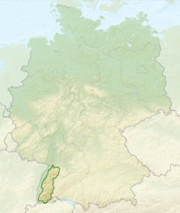
351:Creative Commons Attribution-Share Alike 3.0
275:
244:Deutschland_Naturraeumliche_Grossregionen.png
214:Deutschland Naturraeumliche Grossregionen.png
182:
132:
228:
193:
14:
311:– to copy, distribute and transmit the work
828:Ŝablono:Informkesto geografiaĵo/ekzemploj2
715:The following other wikis use this file:
171:Naturräumlichen Großregionen Deutschlands
135:Relief Map of Germany, Black Forest.png
728:Knowledge:Voorbladartikel week 52 2017
362:
121:
298:Attribution-Share Alike 3.0 Unported
614:
286:
281:
13:
1078:
505:
499:
272:
165:Deutschlandkarte mit Umrissen des
159:
139:
122:
68:
1112:
1085:
504:
414:licensed with Cc-by-sa-3.0, GFDL
694:
490:
322:Under the following conditions:
293:This file is licensed under the
285:
280:
274:
217:
206:
89:
31:
21:
733:Knowledge:Voorbladartikels 2017
500:The Black Forest within Germany
487:
140:
710:
618:
486:
372:File:Relief_Map_of_Germany.png
160:
26:
1:
948:ബ്ലാക്ക് ഫോറസ്റ്റ് (പർവത വനം)
198:This file was derived from:
36:
690:
512:Items portrayed in this file
268:
7:
1075:
984:Usage on sco.wikipedia.org
964:Usage on pl.wikivoyage.org
904:Usage on it.wikivoyage.org
749:Usage on ast.wikipedia.org
739:Usage on arz.wikipedia.org
374:licensed with Cc-by-sa-3.0
175:Bundesamtes für Naturschutz
10:
1117:
1064:Usage on zh.wikipedia.org
1054:Usage on www.wikidata.org
1044:Usage on ur.wikipedia.org
1034:Usage on tr.wikipedia.org
1024:Usage on th.wikipedia.org
1014:Usage on ta.wikipedia.org
1004:Usage on sl.wikipedia.org
994:Usage on sk.wikipedia.org
974:Usage on ro.wikipedia.org
954:Usage on pl.wikipedia.org
944:Usage on ml.wikipedia.org
934:Usage on lb.wikipedia.org
924:Usage on ka.wikipedia.org
914:Usage on ja.wikipedia.org
894:Usage on he.wikipedia.org
884:Usage on ga.wikipedia.org
874:Usage on fr.wikipedia.org
864:Usage on fi.wikipedia.org
854:Usage on fa.wikipedia.org
844:Usage on eu.wikipedia.org
834:Usage on es.wikipedia.org
819:Usage on eo.wikipedia.org
809:Usage on de.wikipedia.org
799:Usage on da.wikipedia.org
789:Usage on cs.wikipedia.org
779:Usage on ca.wikipedia.org
769:Usage on bn.wikipedia.org
759:Usage on bh.wikipedia.org
719:Usage on af.wikipedia.org
683:Equirectangular projection
469:1979x2321 (5766960 Bytes)
460:1979x2322 (5753037 Bytes)
451:1980x2322 (5911072 Bytes)
441:1826x2318 (5615307 Bytes)
431:1826x2318 (5641169 Bytes)
421:1826x2318 (5659071 Bytes)
401:1000x1185 (1766531 Bytes)
391:1000x1185 (1733013 Bytes)
381:1000x1185 (1796090 Bytes)
336:same or compatible license
155:Equirectangular projection
129:
124:
615:
235:Relief_Map_of_Germany.png
203:Relief Map of Germany.png
16:
489:
302:
96:This is a file from the
41:
813:Benutzer:Triplec85/BW-1
672:
185:
100:. Information from its
103:description page there
46:Size of this preview:
1089:Horizontal resolution
677:with outlines of the
465:2008-06-11T19:04:47Z
456:2008-06-12T09:03:16Z
447:2008-06-12T10:16:41Z
437:2011-09-14T18:57:42Z
427:2011-09-22T18:51:25Z
417:2011-09-29T17:01:59Z
397:2010-08-28T12:03:54Z
387:2010-08-28T16:40:16Z
377:2010-08-28T17:48:23Z
149:with outlines of the
173:nach dem System des
62:1,000 × 1,185 pixels
1097:Vertical resolution
773:কালো বন পর্বতশ্রেণী
651:02:40, 28 July 2013
363:Original upload log
317:– to adapt the work
187:28 July 2013, 02:27
52:Other resolutions:
393:мелкие исправления
237:: derivative work
1104:
1103:
888:An Fhoraois Dhubh
711:Global file usage
688:
586:copyright license
572:copyright license
498:
265:
264:
256:derivative work:
118:
117:
98:Wikimedia Commons
32:Global file usage
1108:
1086:
663:
625:
542:copyright status
528:copyright status
496:
358:
355:
352:
349:
346:
338:as the original.
295:Creative Commons
289:
288:
284:
283:
278:
277:
221:
210:
188:
164:
144:
136:
130:
114:
93:
92:
86:
80:
78:
65:
58:405 × 480 pixels
54:202 × 240 pixels
48:506 × 600 pixels
1116:
1115:
1111:
1110:
1109:
1107:
1106:
1105:
1074:
709:
696:
689:
669:
661:
617:
616:
613:
612:
611:
610:
609:
608:
607:
606:
604:
592:
591:
590:
588:
569:
568:
567:
566:
565:
564:
563:
562:
560:
548:
547:
546:
544:
525:
524:
523:
522:
521:
519:
503:
502:
501:
365:
360:
359:
356:
353:
350:
347:
344:
343:
301:
290:
271:
266:
178:
158:
134:
127:
120:
119:
108:
107:
106:is shown below.
82:
76:
74:
67:
66:
51:
12:
11:
5:
1114:
1102:
1101:
1098:
1094:
1093:
1090:
1077:
1073:
1072:
1071:
1070:
1062:
1061:
1060:
1052:
1051:
1050:
1042:
1041:
1040:
1032:
1031:
1030:
1022:
1021:
1020:
1012:
1011:
1010:
1002:
1001:
1000:
992:
991:
990:
982:
981:
980:
978:Pădurea Neagră
972:
971:
970:
962:
961:
960:
952:
951:
950:
942:
941:
940:
932:
931:
930:
922:
921:
920:
912:
911:
910:
902:
901:
900:
892:
891:
890:
882:
881:
880:
872:
871:
870:
862:
861:
860:
852:
851:
850:
842:
841:
840:
832:
831:
830:
825:
817:
816:
815:
807:
806:
805:
797:
796:
795:
787:
786:
785:
777:
776:
775:
767:
766:
765:
757:
756:
755:
747:
746:
745:
743:الغابة السوداء
737:
736:
735:
730:
725:
712:
708:
707:
702:
692:
687:
686:
671:
667:
664:
660:1,000 × 1,185
658:
653:
648:
644:
643:
640:
637:
634:
631:
628:
620:
605:
600:
598:
597:
596:
594:
593:
589:
584:
582:
581:
580:
579:
577:
573:
561:
556:
554:
553:
552:
550:
549:
545:
540:
538:
537:
536:
535:
533:
529:
520:
515:
513:
510:
509:
508:
507:
495:
494:
491:
488:
479:Uploaded with
476:
475:
474:
473:
463:
454:
445:
435:
425:
408:
407:
406:
405:
395:
385:
364:
361:
342:
341:
340:
339:
329:
320:
319:
318:
312:
305:You are free:
292:
291:
273:
270:
267:
263:
262:
261:
260:
254:
241:
230:
226:
225:
224:
223:
211:
195:
191:
190:
184:
180:
179:
145:Relief map of
137:
128:
126:
123:
116:
115:
94:
84:
83:
45:
40:
39:
34:
29:
24:
19:
9:
6:
4:
3:
2:
1113:
1099:
1096:
1095:
1091:
1088:
1087:
1084:
1081:
1069:
1066:
1065:
1063:
1059:
1056:
1055:
1053:
1049:
1046:
1045:
1043:
1039:
1036:
1035:
1033:
1029:
1026:
1025:
1023:
1019:
1016:
1015:
1013:
1009:
1006:
1005:
1003:
999:
996:
995:
993:
989:
986:
985:
983:
979:
976:
975:
973:
969:
966:
965:
963:
959:
956:
955:
953:
949:
946:
945:
943:
939:
936:
935:
933:
929:
926:
925:
923:
919:
916:
915:
913:
909:
906:
905:
903:
899:
896:
895:
893:
889:
886:
885:
883:
879:
876:
875:
873:
869:
866:
865:
863:
859:
856:
855:
853:
849:
846:
845:
843:
839:
836:
835:
833:
829:
826:
824:
821:
820:
818:
814:
811:
810:
808:
804:
801:
800:
798:
794:
791:
790:
788:
784:
781:
780:
778:
774:
771:
770:
768:
764:
763:ब्लैक फॉरेस्ट
761:
760:
758:
754:
751:
750:
748:
744:
741:
740:
738:
734:
731:
729:
726:
724:
721:
720:
718:
717:
716:
706:
703:
701:
698:
697:
684:
680:
676:
670:
665:
659:
657:
654:
652:
649:
646:
645:
641:
638:
635:
632:
629:
627:
626:
624:
603:
599:
587:
583:
559:
555:
543:
539:
518:
514:
511:
492:
485:
484:
483:
482:
472:
468:
464:
462:
459:
455:
453:
450:
446:
444:
440:
436:
434:
430:
426:
424:
420:
416:
415:
413:
410:
409:
404:
400:
396:
394:
390:
386:
384:
380:
376:
375:
373:
370:
369:
368:
348:CC BY-SA 3.0
337:
333:
330:
327:
324:
323:
321:
316:
313:
310:
307:
306:
304:
303:
299:
296:
279:
259:
255:
253:
250:, shading by
249:
245:
242:
240:
236:
233:
232:
231:
227:
222:
220:
215:
212:
209:
204:
201:
200:
199:
196:
192:
181:
176:
172:
168:
163:
156:
152:
148:
143:
138:
131:
112:
105:
104:
99:
95:
88:
87:
81:
72:
71:Original file
63:
59:
55:
49:
44:
38:
35:
33:
30:
28:
25:
23:
20:
18:
15:
1082:
1079:
988:Black Forest
908:Foresta Nera
848:Oihan Beltza
823:Nigra Arbaro
753:Selva Prieta
714:
700:Black Forest
679:Black Forest
622:
619:File history
481:derivativeFX
478:
477:
470:
467:NordNordWest
461:
458:NordNordWest
452:
449:NordNordWest
442:
439:NordNordWest
432:
429:NordNordWest
422:
419:NordNordWest
402:
392:
382:
366:
331:
325:
314:
308:
248:NordNordWest
197:
167:Schwarzwalds
161:
151:Black Forest
141:
111:You can help
101:
69:
22:File history
1008:Schwarzwald
998:Schwarzwald
968:Schwarzwald
958:Schwarzwald
938:Schwarzwald
878:Forêt-Noire
868:Schwarzwald
838:Selva Negra
803:Schwarzwald
793:Schwarzwald
783:Selva Negra
668:Sitacuisses
558:copyrighted
532:copyrighted
332:share alike
326:attribution
258:Sitacuisses
133:Description
1038:Kara Orman
928:შვარცვალდი
918:シュヴァルツヴァルト
898:היער השחור
691:File usage
636:Dimensions
383:Рельеф дна
27:File usage
1100:33.01 dpc
1092:33.01 dpc
1048:سیاہ جنگل
1018:கருங்காடு
858:جنگل سیاه
723:Swartwoud
662:(1.48 MB)
633:Thumbnail
630:Date/Time
269:Licensing
162:Deutsch:
142:English:
77:image/png
1076:Metadata
493:Captions
399:Виктор В
389:Виктор В
379:Виктор В
315:to remix
309:to share
300:license.
239:Виктор_В
37:Metadata
675:Germany
647:current
642:Comment
517:depicts
497:English
433:ergänzt
216::
205::
147:Germany
125:Summary
73:
443:update
252:Lencer
229:Author
194:Source
177:(BfN).
169:gemäß
1058:Q4204
1028:ป่าดำ
705:Bross
189:(UTC)
639:User
357:true
354:true
183:Date
17:File
1068:黑林山
423:upd
681:.
246::
153:.
60:|
56:|
50:.
113:.
79:)
64:.
Text is available under the Creative Commons Attribution-ShareAlike License. Additional terms may apply.


