239:
733:"}},"text\/plain":{"en":{"":"inception"}}},"{\"value\":{\"time\":\"+2012-03-06T00:00:00Z\",\"timezone\":0,\"before\":0,\"after\":0,\"precision\":11,\"calendarmodel\":\"http:\\\/\\\/www.wikidata.org\\\/entity\\\/Q1985727\"},\"type\":\"time\"}":{"text\/html":{"en":{"P571":"6 March 2012"}},"text\/plain":{"en":{"P571":"6 March 2012"}}}}": -->
43:
534:
334:
339:
201:
91:
546:"}},"text\/plain":{"en":{"P2699":"https:\/\/commons.wikimedia.org\/wiki\/user:Nzeemin"}}},"{\"value\":{\"entity-type\":\"property\",\"numeric-id\":2093,\"id\":\"P2093\"},\"type\":\"wikibase-entityid\"}":{"text\/html":{"en":{"":"
554:"}},"text\/plain":{"en":{"P2093":"Nzeemin","P4174":"Nzeemin"}}},"{\"value\":{\"entity-type\":\"property\",\"numeric-id\":4174,\"id\":\"P4174\"},\"type\":\"wikibase-entityid\"}":{"text\/html":{"en":{"":"
957:
689:"}},"text\/plain":{"en":{"":"copyright license"}}},"{\"value\":{\"entity-type\":\"item\",\"numeric-id\":19068220,\"id\":\"Q19068220\"},\"type\":\"wikibase-entityid\"}":{"text\/html":{"en":{"P275":"
645:"}},"text\/plain":{"en":{"":"copyright status"}}},"{\"value\":{\"entity-type\":\"item\",\"numeric-id\":50423863,\"id\":\"Q50423863\"},\"type\":\"wikibase-entityid\"}":{"text\/html":{"en":{"P6216":"
470:"}},"text\/plain":{"en":{"":"depicts"}}},"{\"value\":{\"entity-type\":\"item\",\"numeric-id\":61868351,\"id\":\"Q61868351\"},\"type\":\"wikibase-entityid\"}":{"text\/html":{"en":{"P180":"
538:"}},"text\/plain":{"en":{"":"creator"}}},"{\"value\":{\"entity-type\":\"property\",\"numeric-id\":2699,\"id\":\"P2699\"},\"type\":\"wikibase-entityid\"}":{"text\/html":{"en":{"":"
474:"}},"text\/plain":{"en":{"P180":"map"}}},"{\"value\":{\"entity-type\":\"item\",\"numeric-id\":1875,\"id\":\"Q1875\"},\"type\":\"wikibase-entityid\"}":{"text\/html":{"en":{"P180":"
641:
809:
550:"}},"text\/plain":{"en":{"":"author name string"}}},"{\"value\":\"Nzeemin\",\"type\":\"string\"}":{"text\/html":{"en":{"P2093":"Nzeemin","P4174":"
542:"}},"text\/plain":{"en":{"":"URL"}}},"{\"value\":\"https:\\\/\\\/commons.wikimedia.org\\\/wiki\\\/user:Nzeemin\",\"type\":\"string\"}":{"text\/html":{"en":{"P2699":"
997:
987:
380:– You must give appropriate credit, provide a link to the license, and indicate if changes were made. You may do so in any reasonable manner, but not in any way that suggests the licensor endorses you or your use.
972:
551:
912:
1211:
690:
646:
471:
543:
642:
555:
547:
539:
475:
730:
686:
535:
467:
932:
57:
53:
47:
102:
874:
70:
869:
177:
693:"}},"text\/plain":{"en":{"P275":"Creative Commons Attribution-ShareAlike 2.0 Generic"}}}}": -->
312:
967:
902:
937:
716:
672:
504:
1222:
This file contains additional information, probably added from the digital camera or scanner used to create or digitize it.
952:
387:
1077:
656:
620:
607:
592:
521:
740:
700:
565:
488:
1142:
1082:
942:
627:
349:
1225:
If the file has been modified from its original state, some details may not fully reflect the modified file.
892:
808:
803:
61:
42:
478:"}},"text\/plain":{"en":{"P180":"Arkhangelsk Oblast"}}}}": -->
386:– If you remix, transform, or build upon the material, you must distribute your contributions under the
558:"}},"text\/plain":{"en":{"":"Wikimedia username"}}}}": -->
649:"}},"text\/plain":{"en":{"P6216":"copyrighted"}}}}": -->
1107:
835:
The following pages on the
English Knowledge use this file (pages on other projects are not listed):
110:
1122:
1047:
1007:
1052:
599:
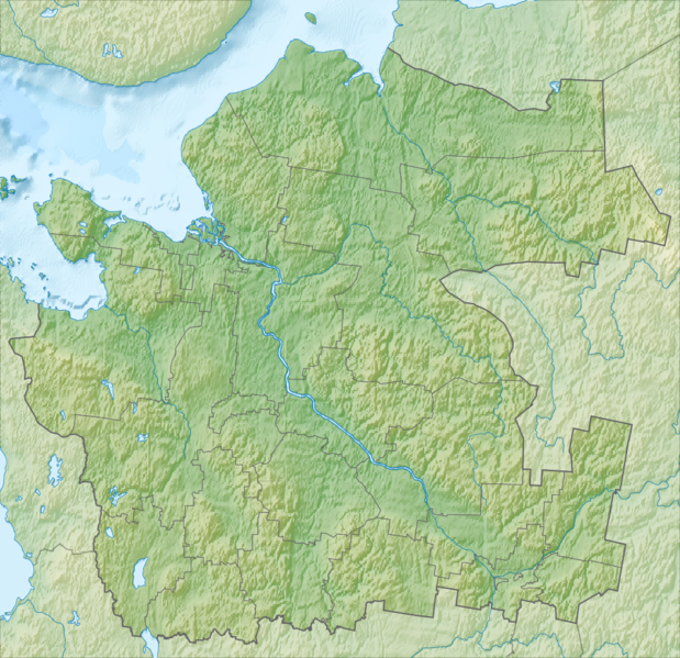
145:Физическая карта Архангельской области (только основная часть, без Ненецкого АО и островов).
238:
1202:
1157:
346:
273:
This map may be incomplete, and may contain errors. Don't rely solely on it for navigation.
8:
1017:
1162:
1037:
977:
962:
927:
207:
1167:
854:
320:
97:
421:
1253:
922:
1197:
844:
268:
1187:
1152:
859:
839:
224:
819:
750:
710:
666:
575:
515:
498:
864:
849:
1182:
1147:
1137:
1062:
211:
1172:
1067:
1022:
776:
Click on a date/time to view the file as it appeared at that time.
200:
1078:
Wikiproyecto:Ilustración/Taller de
Cartografía/Realizaciones/Asia
958:Шаблон:На карце/Расія Архангельская вобласць (мацерыковая частка)
291:
1192:
1177:
1143:
Modèle:Géolocalisation/Oblast d'Arkhangelsk (continental)
1112:
903:Şablon:Yer xəritəsi Rusiya Arxangelsk vilayəti (materik hissə)
1087:
1102:
1092:
1072:
165:
85:
1032:
1132:
918:Ҡалып:ПозКарта Рәсәй Архангельск өлкәһе (материк өлөшө)
452:
Add a one-line explanation of what this file represents
430:
If inappropriate please set warp_status = skip to hide.
875:
833:
1083:
Plantilla:Mapa de localización de Óblast de Arcángel
883:
774:
109:
Commons is a freely licensed media file repository.
998:টেমপ্লেট:অবস্থান মানচিত্র Russia Arkhangelsk Oblast
717:
Creative
Commons Attribution-ShareAlike 2.0 Generic
691:
Creative
Commons Attribution-ShareAlike 2.0 Generic
544:
https:\/\/commons.wikimedia.org\/wiki\/user:Nzeemin
416:
323:Attribution-ShareAlike 2.0 license (CC-BY-SA 2.0).
319:OpenStreetMap data and maps are licensed under the
1123:Vorlage:Positionskarte Russland Oblast Archangelsk
1048:Vorlage:Positionskarte Russland Oblast Archangelsk
870:Module:Location map/data/Russia Arkhangelsk Oblast
75:(994 × 962 pixels, file size: 977 KB, MIME type:
1053:Knowledge:Kartenwerkstatt/Positionskarten/Europa
1008:Plantilya:Location map Russia Arkhangelsk Oblast
178:File:Outline Map Archangelsk Oblast mainland.svg
397:https://creativecommons.org/licenses/by-sa/2.0
90:
1108:Malline:Sijaintikartta Venäjä Arkangelin alue
403:Creative Commons Attribution-Share Alike 2.0
327:
307:
279:
259:
161:
132:
297:
287:
230:
220:
171:
14:
893:قالب:Location map Russia Arkhangelsk Oblast
363:– to copy, distribute and transmit the work
1038:Skabelon:Kortpositioner Arkhangelsk oblast
600:https://commons.wikimedia.org/user:Nzeemin
271:project data, collected by the community.
262:Relief Map Archangelsk Oblast mainland.png
256:
135:Relief Map Archangelsk Oblast mainland.png
885:The following other wikis use this file:
151:Координаты для GMT: -R35.7/50.7/60.5/66.9
424:Georeference the map in Wikimaps Warper
1198:Prigorodny (oblast d'Arkhangelsk)
460:Физическая карта Архангельской области
121:
1203:Oussatchiovskaïa (raïon de Kargopol)
1158:Morchtchikhinskaïa (Petchnikovskoïe)
988:Шаблон:ПК Русия Архангелска област 2
1153:Goujovo (oblast d'Arkhangelsk)
767:
350:Attribution-Share Alike 2.0 Generic
338:
333:
185:GSHHS for rivers, lakes and the sea
13:
1220:
1018:Šablona:LocMap Archangelská oblast
465:
459:
451:
324:
205:
139:
122:
68:
1270:
1227:
464:
1163:Morchtchikhinskaïa (Pavlovskoïe)
973:Уфцюга (прыток Паўночнай Дзвіны)
834:
442:
374:Under the following conditions:
345:This file is licensed under the
337:
332:
326:
237:
199:
190:ETOPO1 for relief and bathymetry
89:
31:
21:
439:
182:OpenStreetMap for region bounds
140:
1168:Fominskaïa (raïon de Kargopol)
880:
771:
438:
26:
1:
422:
36:
830:
484:Items portrayed in this file
251:
7:
1217:
1119:Usage on frr.wikipedia.org
1004:Usage on ceb.wikipedia.org
267:This map was created from
10:
1275:
1129:Usage on fr.wikipedia.org
1099:Usage on fi.wikipedia.org
1059:Usage on es.wikipedia.org
1044:Usage on de.wikipedia.org
1029:Usage on da.wikipedia.org
1014:Usage on cs.wikipedia.org
994:Usage on bn.wikipedia.org
984:Usage on bg.wikipedia.org
949:Usage on be.wikipedia.org
913:Юрас (Кузнечиха ҡушылдығы)
909:Usage on ba.wikipedia.org
899:Usage on az.wikipedia.org
889:Usage on ar.wikipedia.org
388:same or compatible license
302:OpenStreetMap contributors
154:Инструменты: GMT, Inkscape
129:
124:
1138:Parc national du Kenozero
768:
193:
16:
441:
354:
96:This is a file from the
41:
1188:Bolchaïa Kondratovskaïa
933:Кома (Мезень ҡушылдығы)
825:
164:
100:. Information from its
103:description page there
46:Size of this preview:
1231:Horizontal resolution
1183:Pogost (Oukhotskoïe)
1239:Vertical resolution
804:17:34, 6 March 2012
369:– to adapt the work
52:Other resolutions:
1178:Pogost Navolotchny
1173:Niz (Ochevenskoïe)
968:Вель (прыток Вагі)
621:Wikimedia username
608:author name string
556:Wikimedia username
548:author name string
522:Arkhangelsk Oblast
476:Arkhangelsk Oblast
283:(see file history)
148:Проекция: Меркатор
1262:
1261:
1212:more global usage
1113:Arkangelin satama
881:Global file usage
855:Lake Lyokshmozero
828:
701:copyright license
687:copyright license
458:
450:
435:
434:
431:
316:
313:Reusing this file
292:openstreetmap.org
274:
248:
247:
210:was created with
118:
117:
98:Wikimedia Commons
32:Global file usage
1266:
1256:
1254:www.inkscape.org
1228:
816:
778:
657:copyright status
643:copyright status
630:
625:
615:
612:
602:
597:
456:
448:
429:
428:
426:
425:
410:
407:
404:
401:
398:
390:as the original.
347:Creative Commons
341:
340:
336:
335:
330:
329:
321:Creative Commons
310:
272:
263:
257:
241:
203:
195:
167:
144:
136:
130:
114:
93:
92:
86:
80:
78:
65:
62:994 × 962 pixels
58:496 × 480 pixels
54:248 × 240 pixels
48:619 × 599 pixels
1274:
1273:
1269:
1268:
1267:
1265:
1264:
1263:
1252:
1216:
1148:Bolchoï Khalouï
1103:Arkangelin alue
938:Кысская Рассоха
879:
836:
829:
822:
814:
770:
769:
766:
765:
764:
763:
762:
761:
760:
759:
757:
747:
746:
745:
743:
728:
727:
726:
725:
724:
723:
722:
721:
719:
707:
706:
705:
703:
684:
683:
682:
681:
680:
679:
678:
677:
675:
663:
662:
661:
659:
640:
639:
638:
637:
636:
635:
634:
633:
632:
631:
626:
623:
617:
616:
613:
610:
604:
603:
598:
595:
586:
585:
584:
582:
572:
571:
570:
568:
533:
532:
531:
530:
529:
528:
527:
526:
524:
513:
512:
511:
510:
509:
507:
495:
494:
493:
491:
463:
462:
461:
454:
453:
436:
423:
420:
412:
411:
408:
405:
402:
399:
396:
395:
353:
342:
303:
275:
261:
254:
249:
242:
216:
215:
157:
134:
127:
120:
119:
108:
107:
106:is shown below.
82:
76:
74:
67:
66:
51:
12:
11:
5:
1272:
1260:
1259:
1258:
1257:
1248:
1244:
1243:
1240:
1236:
1235:
1232:
1219:
1214:of this file.
1208:
1207:
1206:
1205:
1200:
1195:
1190:
1185:
1180:
1175:
1170:
1165:
1160:
1155:
1150:
1145:
1140:
1135:
1127:
1126:
1125:
1117:
1116:
1115:
1110:
1105:
1097:
1096:
1095:
1090:
1085:
1080:
1075:
1070:
1065:
1063:Bahía de Dviná
1057:
1056:
1055:
1050:
1042:
1041:
1040:
1035:
1027:
1026:
1025:
1020:
1012:
1011:
1010:
1002:
1001:
1000:
992:
991:
990:
982:
981:
980:
975:
970:
965:
960:
955:
953:Дзвінская губа
947:
946:
945:
940:
935:
930:
925:
920:
915:
907:
906:
905:
897:
896:
895:
882:
878:
877:
872:
867:
862:
857:
852:
847:
845:Lake Kozhozero
842:
832:
827:
826:
824:
820:
817:
811:
806:
801:
797:
796:
793:
790:
787:
784:
781:
773:
758:
755:
753:
752:
751:
749:
748:
744:
739:
737:
736:
735:
734:
732:
720:
715:
713:
712:
711:
709:
708:
704:
699:
697:
696:
695:
694:
692:
688:
676:
671:
669:
668:
667:
665:
664:
660:
655:
653:
652:
651:
650:
648:
644:
619:
618:
606:
605:
591:
590:
589:
588:
587:
583:
580:
578:
577:
576:
574:
573:
569:
564:
562:
561:
560:
559:
557:
553:
549:
545:
541:
537:
525:
520:
518:
517:
516:
514:
508:
503:
501:
500:
499:
497:
496:
492:
487:
485:
482:
481:
480:
479:
477:
473:
469:
455:
447:
446:
443:
440:
433:
432:
418:
417:Georeferencing
414:
413:
394:
393:
392:
391:
381:
372:
371:
370:
364:
357:You are free:
344:
343:
325:
317:
305:
304:
301:
299:
295:
294:
289:
285:
284:
281:
277:
276:
266:
264:
255:
253:
250:
246:
245:
244:
243:
236:
232:
231:Other versions
228:
227:
222:
218:
217:
198:
197:
196:
191:
188:
187:
186:
183:
173:
169:
168:
163:
159:
158:
156:
155:
152:
149:
137:
128:
126:
123:
116:
115:
94:
84:
83:
45:
40:
39:
34:
29:
24:
19:
9:
6:
4:
3:
2:
1271:
1255:
1251:
1250:
1249:
1247:Software used
1246:
1245:
1241:
1238:
1237:
1233:
1230:
1229:
1226:
1223:
1215:
1213:
1204:
1201:
1199:
1196:
1194:
1193:Stoletovskaïa
1191:
1189:
1186:
1184:
1181:
1179:
1176:
1174:
1171:
1169:
1166:
1164:
1161:
1159:
1156:
1154:
1151:
1149:
1146:
1144:
1141:
1139:
1136:
1134:
1131:
1130:
1128:
1124:
1121:
1120:
1118:
1114:
1111:
1109:
1106:
1104:
1101:
1100:
1098:
1094:
1093:Lago Undozero
1091:
1089:
1086:
1084:
1081:
1079:
1076:
1074:
1071:
1069:
1066:
1064:
1061:
1060:
1058:
1054:
1051:
1049:
1046:
1045:
1043:
1039:
1036:
1034:
1031:
1030:
1028:
1024:
1021:
1019:
1016:
1015:
1013:
1009:
1006:
1005:
1003:
999:
996:
995:
993:
989:
986:
985:
983:
979:
976:
974:
971:
969:
966:
964:
961:
959:
956:
954:
951:
950:
948:
944:
941:
939:
936:
934:
931:
929:
926:
924:
921:
919:
916:
914:
911:
910:
908:
904:
901:
900:
898:
894:
891:
890:
888:
887:
886:
876:
873:
871:
868:
866:
863:
861:
860:Lake Undozero
858:
856:
853:
851:
848:
846:
843:
841:
840:Lake Kenozero
838:
837:
823:
818:
812:
810:
807:
805:
802:
799:
798:
794:
791:
788:
785:
782:
780:
779:
777:
754:
742:
738:
718:
714:
702:
698:
674:
670:
658:
654:
629:
622:
609:
601:
594:
579:
567:
563:
523:
519:
506:
502:
490:
486:
483:
444:
437:
427:
419:
415:
400:CC BY-SA 2.0
389:
385:
382:
379:
376:
375:
373:
368:
365:
362:
359:
358:
356:
355:
351:
348:
331:
322:
318:
314:
309:
306:
300:
296:
293:
290:
286:
282:
278:
270:
269:OpenStreetMap
265:
258:
240:
235:
234:
233:
229:
226:
223:
219:
213:
209:
202:
192:
189:
184:
181:
180:
179:
176:
175:
174:
170:
160:
153:
150:
147:
146:
143:
138:
131:
112:
105:
104:
99:
95:
88:
87:
81:
72:
71:Original file
63:
59:
55:
49:
44:
38:
35:
33:
30:
28:
25:
23:
20:
18:
15:
1224:
1221:
1209:
1068:Río Víchegda
1023:Mroží ostrov
943:Төньяҡ Двина
884:
775:
772:File history
756:6 March 2012
383:
377:
366:
360:
166:6 March 2012
141:
111:You can help
101:
69:
22:File history
1088:Río Vayenga
1033:Jula (flod)
673:copyrighted
647:copyrighted
384:share alike
378:attribution
260:Description
133:Description
1133:Kholmogory
865:Lake Varsh
850:Lake Lacha
831:File usage
813:994 × 962
789:Dimensions
581:some value
308:Permission
206:This PNG
27:File usage
1242:35.43 dpc
1234:35.43 dpc
786:Thumbnail
783:Date/Time
741:inception
731:inception
252:Licensing
142:Русский:
77:image/png
1218:Metadata
1073:Río Peza
815:(977 KB)
445:Captions
367:to remix
361:to share
352:license.
212:Inkscape
194:Own work
37:Metadata
978:Ваеньга
963:Віледзь
928:Домгиль
821:Nzeemin
800:current
795:Comment
628:Nzeemin
614:Nzeemin
566:creator
552:Nzeemin
536:creator
489:depicts
468:depicts
457:Russian
449:English
298:Creator
225:Nzeemin
208:graphic
125:Summary
73:
923:Васина
288:Source
221:Author
204:
172:Source
1210:View
792:User
409:true
406:true
280:Date
162:Date
17:File
593:URL
540:URL
505:map
472:map
624::
611::
596::
60:|
56:|
50:.
315:)
311:(
214:.
113:.
79:)
64:.

