583:"}},"text\/plain":{"en":{"":"inception"}}},"{\"value\":{\"time\":\"+2012-04-21T00:00:00Z\",\"timezone\":0,\"before\":0,\"after\":0,\"precision\":11,\"calendarmodel\":\"http:\\\/\\\/www.wikidata.org\\\/entity\\\/Q1985727\"},\"type\":\"time\"}":{"text\/html":{"en":{"P571":"21 April 2012"}},"text\/plain":{"en":{"P571":"21 April 2012"}}}}": -->
250:
33:
299:
305:
310:
85:
539:"}},"text\/plain":{"en":{"":"copyright license"}}},"{\"value\":{\"entity-type\":\"item\",\"numeric-id\":14946043,\"id\":\"Q14946043\"},\"type\":\"wikibase-entityid\"}":{"text\/html":{"en":{"P275":"
495:"}},"text\/plain":{"en":{"":"copyright status"}}},"{\"value\":{\"entity-type\":\"item\",\"numeric-id\":50423863,\"id\":\"Q50423863\"},\"type\":\"wikibase-entityid\"}":{"text\/html":{"en":{"P6216":"
491:
413:{{Information |Description=Map of Preston, Lancashire, UK with electoral wards shown. Equirectangular map projection on WGS 84 datum, with N/S stretched 165% Geographic limits: *West: 2.83W *East: 2.59W *North: 53.90N *Sout
357:– You must give appropriate credit, provide a link to the license, and indicate if changes were made. You may do so in any reasonable manner, but not in any way that suggests the licensor endorses you or your use.
540:
496:
492:
580:
536:
59:
55:
51:
47:
43:
37:
543:"}},"text\/plain":{"en":{"P275":"Creative Commons Attribution-ShareAlike 3.0 Unported"}}}}": -->
96:
68:
401:
263:
244:
566:
522:
364:
506:
590:
550:
481:
320:
363:– If you remix, transform, or build upon the material, you must distribute your contributions under the
209:
702:
685:
499:"}},"text\/plain":{"en":{"P6216":"copyrighted"}}}}": -->
698:
The following pages on the
English Knowledge use this file (pages on other projects are not listed):
442:
219:
658:
653:
104:
32:
707:
422:
198:
194:
317:
8:
681:
677:
249:
91:
471:
292:
I, the copyright holder of this work, hereby publish it under the following license:
408:
267:
274:
669:
600:
560:
516:
117:
118:
684:, in Lancashire, England in 1950. *{{color||{{0|00}}|bg=#f5c6ff}}
626:
Click on a date/time to view the file as it appeared at that time.
436:
Geographia plan of the County
Borough of Preston & Fulwood U.D.
232:
676:== {{int:filedesc}} == {{Information |Description={{en|Map of
397:
This image is a derivative work of the following images:
79:
73:(SVG file, nominally 758 × 492 pixels, file size: 54 KB)
465:
Add a one-line explanation of what this file represents
696:
624:
567:
Creative
Commons Attribution-ShareAlike 3.0 Unported
541:
Creative
Commons Attribution-ShareAlike 3.0 Unported
103:
Commons is a freely licensed media file repository.
374:https://creativecommons.org/licenses/by-sa/3.0
84:
380:Creative Commons Attribution-Share Alike 3.0
298:
228:
180:
257:
239:
14:
340:– to copy, distribute and transmit the work
36:Size of this PNG preview of this SVG file:
402:File:Preston_UK_ward_map_2010_(blank).svg
150:
124:
392:
115:
321:Attribution-Share Alike 3.0 Unported
270:, created using Ordnance Survey data
264:Preston_UK_ward_map_2010_(blank).svg
245:Preston UK ward map 2010 (blank).svg
617:
309:
304:
13:
470:
464:
295:
291:
201:, in Lancashire, England in 1950.
187:
119:
116:
66:
719:
469:
120:
697:
455:
351:Under the following conditions:
316:This file is licensed under the
308:
303:
297:
248:
83:
21:
452:
214:
204:
188:
183:Preston and Fulwood in 1950.svg
160:
688:*{{color||{{0|00}}|bg=#cdff...
621:
451:
447:, Ordnance Survey, Southampton
140:
26:
1:
428:
243:This file was derived from:
693:
686:en:County Borough of Preston
477:Items portrayed in this file
285:
130:
7:
404:licensed with Cc-by-sa-3.0
10:
724:
365:same or compatible license
177:
172:
703:County Borough of Preston
618:
411:1187x1305 (329725 Bytes)
210:County Borough of Preston
16:
454:
444:OS 1-inch map of Preston
438:, Geographia Ltd, London
331:
90:This is a file from the
31:
675:
231:
94:. Information from its
708:Fulwood Urban District
682:en:Fulwood, Lancashire
678:en:Preston, Lancashire
220:Fulwood Urban District
97:description page there
434:Thorpe, P.H. (1950),
407:2011-04-24T22:48:11Z
654:14:11, 21 April 2012
233:21 April 2012, 13:51
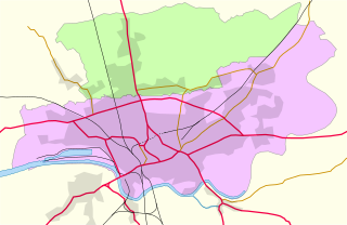
60:2,560 × 1,662 pixels
393:Original upload log
346:– to adapt the work
155:Original upload log
42:Other resolutions:
56:1,280 × 831 pixels
52:1,024 × 665 pixels
691:
551:copyright license
537:copyright license
463:
282:
281:
273:derivative work:
125:
112:
111:
92:Wikimedia Commons
715:
666:
628:
507:copyright status
493:copyright status
461:
387:
384:
381:
378:
375:
367:as the original.
329:
318:Creative Commons
312:
311:
307:
306:
301:
300:
252:
234:
218:
217:
208:
207:
192:
184:
178:
166:
163:
156:
153:
146:
143:
136:
133:
126:
108:
87:
86:
80:
74:
63:
48:640 × 415 pixels
44:320 × 208 pixels
38:758 × 492 pixels
723:
722:
718:
717:
716:
714:
713:
712:
699:
692:
672:
664:
620:
619:
616:
615:
614:
613:
612:
611:
610:
609:
607:
597:
596:
595:
593:
578:
577:
576:
575:
574:
573:
572:
571:
569:
557:
556:
555:
553:
534:
533:
532:
531:
530:
529:
528:
527:
525:
513:
512:
511:
509:
490:
489:
488:
487:
486:
484:
468:
467:
466:
431:
395:
390:
389:
388:
385:
382:
379:
376:
373:
372:
330:
327:
324:
313:
294:
293:
288:
283:
224:
215:
205:
182:
175:
170:
164:
161:
154:
151:
144:
141:
134:
131:
127:
123:
114:
113:
102:
101:
100:is shown below.
76:
72:
65:
64:
41:
12:
11:
5:
721:
711:
710:
705:
695:
690:
689:
674:
670:
667:
661:
656:
651:
647:
646:
643:
640:
637:
634:
631:
623:
608:
605:
603:
602:
601:
599:
598:
594:
589:
587:
586:
585:
584:
582:
570:
565:
563:
562:
561:
559:
558:
554:
549:
547:
546:
545:
544:
542:
538:
526:
521:
519:
518:
517:
515:
514:
510:
505:
503:
502:
501:
500:
498:
494:
485:
480:
478:
475:
474:
473:
472:
460:
459:
456:
453:
449:
448:
439:
430:
427:
421:Uploaded with
418:
417:
416:
415:
394:
391:
371:
370:
369:
368:
358:
349:
348:
347:
341:
334:You are free:
325:
315:
314:
296:
290:
289:
287:
284:
280:
279:
278:
277:
271:
259:
255:
254:
241:
237:
236:
230:
226:
225:
223:
222:
212:
185:
176:
174:
171:
169:
168:
158:
148:
138:
122:
110:
109:
88:
78:
77:
35:
30:
29:
24:
19:
9:
6:
4:
3:
2:
720:
709:
706:
704:
701:
700:
687:
683:
679:
673:
668:
662:
660:
657:
655:
652:
649:
648:
644:
641:
638:
635:
632:
630:
629:
627:
606:21 April 2012
604:
592:
588:
568:
564:
552:
548:
524:
520:
508:
504:
483:
479:
476:
457:
450:
446:
445:
440:
437:
433:
432:
426:
425:
424:
414:
410:
406:
405:
403:
400:
399:
398:
377:CC BY-SA 3.0
366:
362:
359:
356:
353:
352:
350:
345:
342:
339:
336:
335:
333:
332:
326:Attribution:
322:
319:
302:
276:
272:
269:
265:
262:
261:
260:
256:
253:
251:
246:
242:
238:
227:
221:
213:
211:
203:
202:
200:
196:
191:
186:
179:
167:
159:
157:
149:
147:
139:
137:
129:
128:
106:
99:
98:
93:
89:
82:
81:
75:
70:
69:Original file
61:
57:
53:
49:
45:
39:
34:
28:
25:
23:
20:
18:
15:
625:
622:File history
443:
435:
423:derivativeFX
420:
419:
412:
396:
360:
354:
343:
337:
189:
105:You can help
95:
67:
22:File history
523:copyrighted
497:copyrighted
441:(1953-55),
361:share alike
355:attribution
181:Description
694:File usage
663:758 × 492
639:Dimensions
429:References
165:References
27:File usage
636:Thumbnail
633:Date/Time
591:inception
581:inception
409:Nilfanion
286:Licensing
268:Nilfanion
190:English:
145:Licensing
458:Captions
344:to remix
338:to share
323:license.
121:Contents
671:Dr Greg
665:(54 KB)
650:current
645:Comment
482:depicts
462:English
328:Dr Greg
275:Dr Greg
247::
199:Fulwood
195:Preston
193:Map of
173:Summary
135:Summary
71:
258:Author
240:Source
235:(UTC)
680:and
642:User
386:true
383:true
229:Date
197:and
17:File
266::
216:00
206:00
58:|
54:|
50:|
46:|
40:.
162:4
152:3
142:2
132:1
107:.
62:.
Text is available under the Creative Commons Attribution-ShareAlike License. Additional terms may apply.

.svg)