38:
321:
253:
219:
98:
491:
361:
If the
Information Provider does not provide a specific attribution statement, or if you are using Information from several information providers and multiple attributions are not practical for your product or application, you must use the following attribution
569:
238:
According to Public Works and
Government Services Canada / Travaux publics et Services gouvernementaux Canada, Canada has no intention of renewing expired Crown Copyright works in any country, and consequently the
68:
64:
60:
56:
52:
48:
42:
109:
77:
358:
Acknowledge the source of the
Information by including any attribution statement specified by the Information Provider(s) and, where possible, provide a link to this licence;
244:
152:
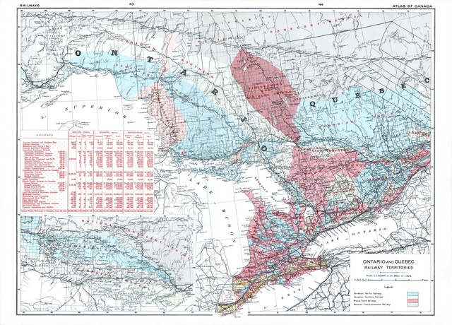
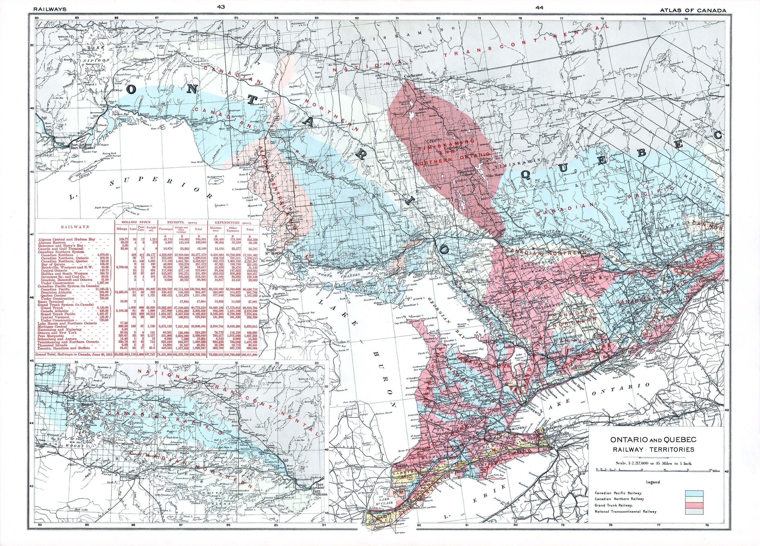
Railway map of
Ontario and Western Quebec. Published by the Government of Canada in 1915. Shows the territories for assigned to each railway.
348:
Copy, modify, publish, translate, adapt, distribute or otherwise use the
Information in any medium, mode or format for any lawful purpose.
172:
533:
This file contains additional information, probably added from the digital camera or scanner used to create or digitize it.
522:
490:
485:
240:
37:
406:
Information subject to other intellectual property rights, including patents, trade-marks and official marks.
302:
536:
If the file has been modified from its original state, some details may not fully reflect the modified file.
518:
The following pages on the
English Knowledge use this file (pages on other projects are not listed):
427:
117:
329:
233:
173:
http://geogratis.gc.ca/api/en/nrcan-rncan/ess-sst/8ef1e0ce-ad93-501f-85e4-8c342ad1908e.html
8:
229:
104:
398:
394:
292:
391:
the names, crests, logos, or other official symbols of the
Information Provider
501:
320:
283:
274:
265:
368:"Contains information licensed under the Open Government Licence – Canada."
388:
third party rights the
Information Provider is not authorized to license;
315:
458:
Click on a date/time to view the file as it appeared at that time.
422:
418:
414:
225:
92:
439:
http://open.canada.ca/en/open-government-licence-canada
171:
Atlas of Canada, 2nd
Edition, 1915. Immediate source:
82:(3,577 × 2,568 pixels, file size: 2.13 MB, MIME type:
516:
456:
116:
Commons is a freely licensed media file repository.
161:
142:
Ontario and Quebec
Railway Territories 1915 map.pdf
236:and was first published before December 31, 1973.
579:Acrobat 5.0 Image Conversion Plug-in for Windows
570:Acrobat 5.0 Image Conversion Plug-in for Windows
182:Government of Canada; Department of the Interior
97:
157:
139:
178:
167:
14:
41:Size of this JPG preview of this PDF file:
243:does not apply. An email is on record at
354:You must, where you do any of the above:
261:
218:
128:
433:Open Government Licence – Canada 2.0
330:Open Government Licence - Canada 2.0
232:worldwide because it was subject to
213:
508:User created page with UploadWizard
13:
531:
319:
251:
146:
129:
75:
615:
538:
523:National Transcontinental Railway
517:
328:This file is licensed under the
217:
96:
21:
558:Date metadata was last modified
147:
453:
26:
1:
293:
31:
513:
189:
7:
550:Date and time of digitizing
528:
381:grant you any right to use:
10:
620:
136:
131:
542:File change date and time
318:
16:
284:
275:
266:
103:This is a file from the
36:
561:06:16, 21 December 2014
545:06:16, 21 December 2014
507:
486:16:21, 21 December 2014
245:ticket:2013122310013986
160:
107:. Information from its
324:
256:
110:description page there
600:Version of PDF format
393:(n.b.: including the
385:Personal Information;
323:
255:
595:1717.44 x 1233.6 pts
69:3,577 × 2,568 pixels
65:2,560 × 1,838 pixels
553:10:23, 10 June 2003
47:Other resolutions:
576:Conversion program
325:
257:
61:1,280 × 919 pixels
57:1,024 × 735 pixels
607:
606:
511:
450:
449:
430:
311:
310:
305:
212:
211:
186:
185:
125:
124:
105:Wikimedia Commons
611:
539:
498:
460:
443:
440:
437:
434:
431:
426:
344:You are free to:
316:
306:
301:
254:
221:
220:
214:
208:
205:
202:
199:
194:
193:
163:
151:
143:
137:
121:
100:
99:
93:
87:
85:
72:
53:640 × 459 pixels
49:320 × 230 pixels
43:800 × 574 pixels
619:
618:
614:
613:
612:
610:
609:
608:
527:
519:
512:
504:
496:
452:
451:
441:
438:
435:
432:
413:
399:Canada Wordmark
295:
286:
277:
268:
264:
252:
234:Crown copyright
228:work is in the
206:
203:
200:
197:
192:
187:
153:
141:
134:
127:
126:
115:
114:
113:is shown below.
89:
84:application/pdf
83:
81:
74:
73:
46:
12:
11:
5:
617:
605:
604:
601:
597:
596:
593:
589:
588:
585:
581:
580:
577:
573:
572:
567:
563:
562:
559:
555:
554:
551:
547:
546:
543:
530:
526:
525:
515:
510:
509:
506:
502:
499:
495:3,577 × 2,568
493:
488:
483:
479:
478:
475:
472:
469:
466:
463:
455:
448:
447:
445:
410:
409:
408:
407:
404:
395:Arms of Canada
389:
386:
373:
372:
371:
370:
364:
363:
359:
351:
350:
349:
338:
337:
334:
333:
326:
309:
308:
259:
258:
249:
222:
210:
209:
191:
188:
184:
183:
180:
176:
175:
169:
165:
164:
159:
155:
154:
144:
135:
133:
130:
123:
122:
101:
91:
90:
40:
35:
34:
29:
24:
19:
9:
6:
4:
3:
2:
616:
602:
599:
598:
594:
591:
590:
586:
583:
582:
578:
575:
574:
571:
568:
566:Software used
565:
564:
560:
557:
556:
552:
549:
548:
544:
541:
540:
537:
534:
524:
521:
520:
505:
500:
494:
492:
489:
487:
484:
481:
480:
476:
473:
470:
467:
464:
462:
461:
459:
446:
444:
429:
424:
420:
416:
411:
405:
402:
400:
396:
390:
387:
384:
383:
382:
380:
377:This licence
375:
374:
369:
366:
365:
360:
357:
356:
355:
352:
347:
346:
345:
342:
341:
340:
339:
336:
335:
331:
327:
322:
317:
314:
313:
307:
304:
300:
296:
291:
287:
282:
278:
273:
269:
262:
260:
250:
248:
246:
242:
235:
231:
230:public domain
227:
223:
216:
215:
201:Public domain
198:Public domain
196:
195:
181:
177:
174:
170:
166:
156:
150:
145:
138:
119:
112:
111:
106:
102:
95:
94:
88:
79:
78:Original file
70:
66:
62:
58:
54:
50:
44:
39:
33:
30:
28:
25:
23:
20:
18:
15:
535:
532:
457:
454:File history
412:
392:
378:
376:
367:
353:
343:
312:
298:
289:
280:
271:
263:
237:
148:
118:You can help
108:
76:
22:File history
140:Description
514:File usage
471:Dimensions
362:statement:
27:File usage
592:Page size
584:Encrypted
503:Oaktree b
497:(2.13 MB)
468:Thumbnail
465:Date/Time
436:OGL-C 2.0
190:Licensing
149:English:
529:Metadata
425: |
421: |
419:français
417: |
397:and the
379:does not
226:Canadian
32:Metadata
482:current
477:Comment
415:English
267:English
132:Summary
80:
297:
294:中文(简体)
288:
279:
276:മലയാളം
270:
179:Author
168:Source
403:; and
224:This
207:false
204:false
474:User
442:true
241:URAA
162:1915
158:Date
17:File
603:1.4
428:+/−
303:+/−
285:한국어
587:no
423:中文
332:.
247:.
67:|
63:|
59:|
55:|
51:|
45:.
401:)
299:∙
290:∙
281:∙
272:∙
120:.
86:)
71:.
Text is available under the Creative Commons Attribution-ShareAlike License. Additional terms may apply.

.svg)