43:
580:"}},"text\/plain":{"en":{"":"inception"}}},"{\"value\":{\"time\":\"+2016-06-02T00:00:00Z\",\"timezone\":0,\"before\":0,\"after\":0,\"precision\":11,\"calendarmodel\":\"http:\\\/\\\/www.wikidata.org\\\/entity\\\/Q1985727\"},\"type\":\"time\"}":{"text\/html":{"en":{"P571":"2 June 2016"}},"text\/plain":{"en":{"P571":"2 June 2016"}}}}": -->
797:
381:
260:
401:","P2093":"Addicted04"}},"text\/plain":{"en":{"P4174":"Addicted04","P2093":"Addicted04"}}},"{\"value\":{\"entity-type\":\"property\",\"numeric-id\":2093,\"id\":\"P2093\"},\"type\":\"wikibase-entityid\"}":{"text\/html":{"en":{"":"
265:
99:
393:"}},"text\/plain":{"en":{"P2699":"https:\/\/commons.wikimedia.org\/wiki\/user:Addicted04"}}},"{\"value\":{\"entity-type\":\"property\",\"numeric-id\":4174,\"id\":\"P4174\"},\"type\":\"wikibase-entityid\"}":{"text\/html":{"en":{"":"
536:"}},"text\/plain":{"en":{"":"copyright license"}}},"{\"value\":{\"entity-type\":\"item\",\"numeric-id\":18199165,\"id\":\"Q18199165\"},\"type\":\"wikibase-entityid\"}":{"text\/html":{"en":{"P275":"
492:"}},"text\/plain":{"en":{"":"copyright status"}}},"{\"value\":{\"entity-type\":\"item\",\"numeric-id\":50423863,\"id\":\"Q50423863\"},\"type\":\"wikibase-entityid\"}":{"text\/html":{"en":{"P6216":"
686:
716:
385:"}},"text\/plain":{"en":{"":"creator"}}},"{\"value\":{\"entity-type\":\"property\",\"numeric-id\":2699,\"id\":\"P2699\"},\"type\":\"wikibase-entityid\"}":{"text\/html":{"en":{"":"
488:
389:"}},"text\/plain":{"en":{"":"URL"}}},"{\"value\":\"https:\\\/\\\/commons.wikimedia.org\\\/wiki\\\/user:Addicted04\",\"type\":\"string\"}":{"text\/html":{"en":{"P2699":"
1231:
397:"}},"text\/plain":{"en":{"":"Wikimedia username"}}},"{\"value\":\"Addicted04\",\"type\":\"string\"}":{"text\/html":{"en":{"P4174":"
1486:
798:
Cneoridium dumosum (Nuttall) Hooker F. Collected March 26, 1960, at an
Elevation of about 1450 Meters on Cerro Quemazón, 15 Miles South of Bahía de Los Angeles, Baja California, México, Apparently for a Southeastward Range Extension of Some 140
306:– You must give appropriate credit, provide a link to the license, and indicate if changes were made. You may do so in any reasonable manner, but not in any way that suggests the licensor endorses you or your use.
398:
1183:
1193:
1188:
1178:
1173:
1168:
1163:
1158:
1153:
1148:
1143:
1138:
1133:
1466:
968:
537:
493:
390:
1520:
231:
489:
402:
394:
386:
577:
533:
382:
69:
73:
65:
61:
57:
53:
47:
1481:
973:
1023:
110:
1213:
82:
1198:
540:"}},"text\/plain":{"en":{"P275":"Creative Commons Attribution-ShareAlike 4.0 International"}}}}": -->
1208:
983:
777:
1063:
1456:
998:
1008:
1476:
1203:
1033:
715:
710:
685:
680:
563:
519:
988:
1043:
1013:
1531:
This file contains additional information, probably added from the digital camera or scanner used to create or digitize it.
1506:
313:
503:
469:
454:
439:
1471:
587:
547:
412:
371:
1018:
772:
1058:
792:
461:
1068:
958:
908:
275:
200:
1381:
1103:
1534:
If the file has been modified from its original state, some details may not fully reflect the modified file.
978:
1128:
993:
813:
762:
757:
752:
747:
655:
650:
42:
312:– If you remix, transform, or build upon the material, you must distribute your contributions under the
405:"}},"text\/plain":{"en":{"":"author name string"}}}}": -->
923:
818:
1038:
823:
767:
496:"}},"text\/plain":{"en":{"P6216":"copyrighted"}}}}": -->
1003:
743:
The following pages on the
English Knowledge use this file (pages on other projects are not listed):
1331:
118:
1446:
446:
1113:
938:
918:
853:
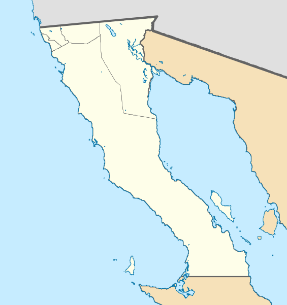
838:
1118:
1078:
963:
1496:
808:
696:
666:
272:
1366:
8:
1123:
1083:
863:
1073:
1511:
1251:
1108:
1028:
208:
105:
361:
247:
I, the copyright holder of this work, hereby publish it under the following license:
154:
833:
828:
803:
221:
1326:
893:
873:
726:
1336:
1093:
898:
883:
1457:
Wikiproyecto:Ilustración/Taller de
Cartografía/Realizaciones/América del Norte
1053:
943:
933:
878:
858:
782:
1321:
1266:
888:
868:
159:
597:
557:
513:
422:
1048:
928:
903:
843:
1271:
1316:
1184:
User:Ty654/List of earthquakes from 2000-present exceeding magnitude 7+
787:
1286:
948:
913:
848:
1194:
User:Ty654/List of earthquakes from 2010-2014 exceeding magnitude 6+
1189:
User:Ty654/List of earthquakes from 2005-2009 exceeding magnitude 6+
1179:
User:Ty654/List of earthquakes from 1980-1984 exceeding magnitude 6+
1174:
User:Ty654/List of earthquakes from 1975-1979 exceeding magnitude 6+
1169:
User:Ty654/List of earthquakes from 1965-1969 exceeding magnitude 6+
1164:
User:Ty654/List of earthquakes from 1960-1964 exceeding magnitude 6+
1159:
User:Ty654/List of earthquakes from 1955-1959 exceeding magnitude 6+
1154:
User:Ty654/List of earthquakes from 1950-1999 exceeding magnitude 7+
1149:
User:Ty654/List of earthquakes from 1950-1954 exceeding magnitude 6+
1144:
User:Ty654/List of earthquakes from 1940-1949 exceeding magnitude 6+
1139:
User:Ty654/List of earthquakes from 1930-1939 exceeding magnitude 6+
1134:
User:Ty654/List of earthquakes from 1900-1949 exceeding magnitude 7+
953:
623:
Click on a date/time to view the file as it appeared at that time.
1098:
1401:
1382:
Sustainability and Sense of Place in the
Sonoran Desert/Vizcaino
1296:
1436:
1416:
1411:
1088:
1431:
1441:
1361:
1346:
1391:
1371:
1306:
1301:
1351:
1341:
1276:
1261:
232:
File:Mexico Baja
California location map (urban areas).svg
1311:
564:
Creative
Commons Attribution-ShareAlike 4.0 International
538:
Creative
Commons Attribution-ShareAlike 4.0 International
186:
93:
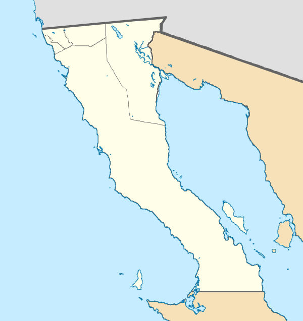
87:(SVG file, nominally 600 × 637 pixels, file size: 1.2 MB)
1291:
673:
correct north-south stretching (correcting file mistake)
969:
Misión
Nuestra Señora del Santísimo Rosario de Viñadaco
355:
Add a one-line explanation of what this file represents
391:
https:\/\/commons.wikimedia.org\/wiki\/user:Addicted04
1426:
1396:
1356:
1332:
Knowledge:Kartenwerkstatt/Positionskarten/Nordamerika
1281:
1256:
1241:
741:
1421:
1246:
1222:
621:
117:
Commons is a freely licensed media file repository.
1406:
1214:
Module:Location map/data/Mexico Baja
California/doc
1199:File talk:Mexico Baja California location map.svg
1209:Module:Location map/data/Mexico Baja California
1024:Misión de Nuestra Señora de Guadalupe del Norte
1447:Ŝablono:Situo sur mapo Meksiko Baja California
323:https://creativecommons.org/licenses/by-sa/4.0
98:
1497:Vorlage:Positionskarte Mexiko Baja California
1367:Vorlage:Positionskarte Mexiko Baja California
974:Misión San Fernando Rey de España de Velicatá
778:Cathedral of Our Lady of Guadalupe (Ensenada)
447:https://commons.wikimedia.org/user:Addicted04
329:Creative Commons Attribution-Share Alike 4.0
253:
182:
140:
1064:San Lorenzo Marine Archipelago National Park
227:
217:
192:
14:
289:– to copy, distribute and transmit the work
46:Size of this PNG preview of this SVG file:
1232:Кеп:Меттиган карта Мексика Лаха Калифорни
1224:The following other wikis use this file:
984:Misión San Miguel Arcángel de la Frontera
276:Attribution-Share Alike 4.0 International
1204:Module:Location map/data/Baja California
1034:Pilot Knob (Imperial County, California)
143:Mexico Baja California location map.svg
1487:پارک ملی مجمعالجزایر دریایی سن لورنزو
999:Misión Santa Catarina Virgen y Mártir
129:
1327:Valle de Guadalupe (Baja California)
1337:Niederkalifornien-Erdbeben von 2010
1044:Puerto Santo Tomás, Baja California
1014:Misión Santo Domingo de la Frontera
733:User created page with UploadWizard
703:more correct north-south stretching
614:
264:
259:
13:
1529:
360:
354:
250:
246:
147:
130:
80:
1563:
1536:
1009:Misión Santa María de los Ángeles
989:Misión San Pedro Mártir de Verona
359:
1059:San Felipe International Airport
742:
345:
300:Under the following conditions:
271:This file is licensed under the
263:
258:
252:
162:, Geographic limits of the map:
97:
31:
21:
793:Ciudad Morelos, Baja California
342:
148:
1322:Punta Prieta (Baja California)
1219:
959:Mexicali International Airport
909:Isla Partida (Baja California)
618:
341:
26:
1:
1104:Tijuana International Airport
203:Marco Geoestadístico Nacional
36:
1467:سان کوئنتین (باخا کالیفرنیا)
1129:User:DarkNight0917/Creations
1069:San Quintín, Baja California
1019:Misión Santo Tomás de Aquino
773:Bahía de los Ángeles Airport
738:
367:Items portrayed in this file
240:
7:
1526:
1493:Usage on frr.wikipedia.org
1272:Vicente Guerrero (Mexicali)
1252:Bahía de Sebastián Vizcaíno
814:El Rosario, Baja California
10:
1568:
1503:Usage on he.wikipedia.org
1463:Usage on fa.wikipedia.org
1453:Usage on es.wikipedia.org
1388:Usage on eo.wikipedia.org
1378:Usage on en.wikibooks.org
1317:El Morro (Baja California)
1238:Usage on de.wikipedia.org
1228:Usage on ce.wikipedia.org
979:Misión San Francisco Borja
314:same or compatible license
137:
132:
1039:Progreso, Baja California
994:Misión San Vicente Ferrer
824:Ensenada, Baja California
615:
16:
1287:Tecate (Baja California)
344:
280:
104:This is a file from the
41:
924:Isla Ángel de la Guarda
819:Emilio López Zamora dam
763:2022–23 Liga TDP season
758:2021–22 Liga TDP season
753:2020–21 Liga TDP season
748:2019–20 Liga TDP season
732:
702:
672:
185:
108:. Information from its
1004:Misión Santa Gertrudis
939:Laguna Salada (Mexico)
919:Isla de Cedros Airport
854:Isla Cabeza de Caballo
839:Guerrero Negro Airport
111:description page there
1482:سد امیلیو لوپز زامورا
1079:Sierra de La Asamblea
681:15:02, 18 August 2023
651:15:04, 18 August 2023
1267:Bahía de los Ángeles
809:El Carrizo Reservoir
768:Bahía de los Ángeles
209:Free use of the data
160:EPSG:3857 projection
70:1,929 × 2,048 pixels
1402:Mexicali (komunumo)
1124:Visita de San Telmo
1119:Visita de Calamajué
1084:Sierra de San Borja
864:Isla Cardonosa Este
295:– to adapt the work
52:Other resolutions:
1437:Insuloj San Benito
1417:Playas de Rosarito
1412:Tijuana (komunumo)
1109:Valle de Guadalupe
1029:Picacho del Diablo
964:Misión El Descanso
711:00:26, 3 June 2016
470:author name string
455:Wikimedia username
403:author name string
395:Wikimedia username
66:964 × 1,024 pixels
1555:
1554:
1521:more global usage
1432:Insuloj Koronadoj
1220:Global file usage
1114:Villa Jesús María
736:
548:copyright license
534:copyright license
353:
237:
236:
126:
125:
106:Wikimedia Commons
32:Global file usage
1559:
1537:
1477:پیکاچو دل دیابلو
1442:Insulo Natividad
1362:Estadio Caliente
1347:Islas San Benito
1074:Sierra de Juárez
834:Guadalupe Island
829:Ensenada Airport
804:Coronado Islands
723:
693:
663:
625:
504:copyright status
490:copyright status
477:
474:
464:
459:
449:
444:
351:
336:
333:
330:
327:
324:
316:as the original.
273:Creative Commons
267:
266:
262:
261:
256:
255:
198:Sources of data:
188:
153:Location map of
152:
144:
138:
122:
101:
100:
94:
88:
77:
74:600 × 637 pixels
62:723 × 768 pixels
58:452 × 480 pixels
54:226 × 240 pixels
48:565 × 600 pixels
1567:
1566:
1562:
1561:
1560:
1558:
1557:
1556:
1525:
1392:Baja California
1372:Estadio Chevron
1218:
894:Isla La Ventana
874:Isla Coloradito
744:
737:
729:
721:
699:
698:GrandEscogriffe
691:
669:
668:GrandEscogriffe
661:
617:
616:
613:
612:
611:
610:
609:
608:
607:
606:
604:
594:
593:
592:
590:
575:
574:
573:
572:
571:
570:
569:
568:
566:
554:
553:
552:
550:
531:
530:
529:
528:
527:
526:
525:
524:
522:
510:
509:
508:
506:
487:
486:
485:
484:
483:
482:
481:
480:
479:
478:
475:
472:
466:
465:
460:
457:
451:
450:
445:
442:
433:
432:
431:
429:
419:
418:
417:
415:
380:
379:
378:
377:
376:
374:
358:
357:
356:
339:
338:
337:
334:
331:
328:
325:
322:
321:
279:
268:
249:
248:
243:
238:
178:
155:Baja California
142:
135:
128:
127:
116:
115:
114:is shown below.
90:
86:
79:
78:
51:
12:
11:
5:
1565:
1553:
1552:
1549:
1545:
1544:
1541:
1528:
1523:of this file.
1517:
1516:
1515:
1514:
1509:
1507:באחה קליפורניה
1501:
1500:
1499:
1491:
1490:
1489:
1484:
1479:
1474:
1469:
1461:
1460:
1459:
1451:
1450:
1449:
1444:
1439:
1434:
1429:
1424:
1419:
1414:
1409:
1404:
1399:
1394:
1386:
1385:
1384:
1376:
1375:
1374:
1369:
1364:
1359:
1354:
1349:
1344:
1339:
1334:
1329:
1324:
1319:
1314:
1309:
1307:Isla de Cedros
1304:
1302:Islas Coronado
1299:
1297:Ejido Eréndira
1294:
1289:
1284:
1279:
1274:
1269:
1264:
1259:
1254:
1249:
1244:
1236:
1235:
1234:
1221:
1217:
1216:
1211:
1206:
1201:
1196:
1191:
1186:
1181:
1176:
1171:
1166:
1161:
1156:
1151:
1146:
1141:
1136:
1131:
1126:
1121:
1116:
1111:
1106:
1101:
1096:
1094:Tecate Airport
1091:
1086:
1081:
1076:
1071:
1066:
1061:
1056:
1051:
1046:
1041:
1036:
1031:
1026:
1021:
1016:
1011:
1006:
1001:
996:
991:
986:
981:
976:
971:
966:
961:
956:
951:
946:
941:
936:
931:
926:
921:
916:
911:
906:
901:
899:Isla Lagartija
896:
891:
886:
884:Isla El Muerto
881:
876:
871:
866:
861:
856:
851:
846:
841:
836:
831:
826:
821:
816:
811:
806:
801:
795:
790:
785:
780:
775:
770:
765:
760:
755:
750:
740:
735:
734:
731:
727:
724:
718:
713:
708:
705:
704:
701:
697:
694:
688:
683:
678:
675:
674:
671:
667:
664:
658:
653:
648:
644:
643:
640:
637:
634:
631:
628:
620:
605:
602:
600:
599:
598:
596:
595:
591:
586:
584:
583:
582:
581:
579:
567:
562:
560:
559:
558:
556:
555:
551:
546:
544:
543:
542:
541:
539:
535:
523:
518:
516:
515:
514:
512:
511:
507:
502:
500:
499:
498:
497:
495:
491:
468:
467:
453:
452:
438:
437:
436:
435:
434:
430:
427:
425:
424:
423:
421:
420:
416:
411:
409:
408:
407:
406:
404:
400:
396:
392:
388:
384:
375:
370:
368:
365:
364:
363:
362:
350:
349:
346:
343:
320:
319:
318:
317:
307:
298:
297:
296:
290:
283:You are free:
270:
269:
251:
245:
244:
242:
239:
235:
234:
229:
228:Other versions
225:
224:
219:
215:
214:
213:
212:
194:
190:
189:
184:
180:
179:
177:
176:
173:
170:
167:
145:
136:
134:
131:
124:
123:
102:
92:
91:
45:
40:
39:
34:
29:
24:
19:
9:
6:
4:
3:
2:
1564:
1550:
1547:
1546:
1542:
1539:
1538:
1535:
1532:
1524:
1522:
1513:
1510:
1508:
1505:
1504:
1502:
1498:
1495:
1494:
1492:
1488:
1485:
1483:
1480:
1478:
1475:
1473:
1472:ایسلا کرونادو
1470:
1468:
1465:
1464:
1462:
1458:
1455:
1454:
1452:
1448:
1445:
1443:
1440:
1438:
1435:
1433:
1430:
1428:
1425:
1423:
1420:
1418:
1415:
1413:
1410:
1408:
1405:
1403:
1400:
1398:
1395:
1393:
1390:
1389:
1387:
1383:
1380:
1379:
1377:
1373:
1370:
1368:
1365:
1363:
1360:
1358:
1355:
1353:
1352:Isla Coronado
1350:
1348:
1345:
1343:
1342:Isla Montague
1340:
1338:
1335:
1333:
1330:
1328:
1325:
1323:
1320:
1318:
1315:
1313:
1310:
1308:
1305:
1303:
1300:
1298:
1295:
1293:
1290:
1288:
1285:
1283:
1280:
1278:
1277:Ejido Tabasco
1275:
1273:
1270:
1268:
1265:
1263:
1260:
1258:
1255:
1253:
1250:
1248:
1245:
1243:
1240:
1239:
1237:
1233:
1230:
1229:
1227:
1226:
1225:
1215:
1212:
1210:
1207:
1205:
1202:
1200:
1197:
1195:
1192:
1190:
1187:
1185:
1182:
1180:
1177:
1175:
1172:
1170:
1167:
1165:
1162:
1160:
1157:
1155:
1152:
1150:
1147:
1145:
1142:
1140:
1137:
1135:
1132:
1130:
1127:
1125:
1122:
1120:
1117:
1115:
1112:
1110:
1107:
1105:
1102:
1100:
1097:
1095:
1092:
1090:
1087:
1085:
1082:
1080:
1077:
1075:
1072:
1070:
1067:
1065:
1062:
1060:
1057:
1055:
1054:Punta Colonet
1052:
1050:
1047:
1045:
1042:
1040:
1037:
1035:
1032:
1030:
1027:
1025:
1022:
1020:
1017:
1015:
1012:
1010:
1007:
1005:
1002:
1000:
997:
995:
992:
990:
987:
985:
982:
980:
977:
975:
972:
970:
967:
965:
962:
960:
957:
955:
952:
950:
947:
945:
944:Los Algodones
942:
940:
937:
935:
934:Laguna Hanson
932:
930:
927:
925:
922:
920:
917:
915:
912:
910:
907:
905:
902:
900:
897:
895:
892:
890:
887:
885:
882:
880:
879:Isla Coronado
877:
875:
872:
870:
867:
865:
862:
860:
859:Isla Calavera
857:
855:
852:
850:
847:
845:
842:
840:
837:
835:
832:
830:
827:
825:
822:
820:
817:
815:
812:
810:
807:
805:
802:
800:
796:
794:
791:
789:
786:
784:
783:Cedros Island
781:
779:
776:
774:
771:
769:
766:
764:
761:
759:
756:
754:
751:
749:
746:
745:
730:
725:
719:
717:
714:
712:
709:
707:
706:
700:
695:
689:
687:
684:
682:
679:
677:
676:
670:
665:
659:
657:
654:
652:
649:
646:
645:
641:
638:
635:
632:
629:
627:
626:
624:
601:
589:
585:
565:
561:
549:
545:
521:
517:
505:
501:
471:
463:
456:
448:
441:
426:
414:
410:
373:
369:
366:
347:
340:
326:CC BY-SA 4.0
315:
311:
308:
305:
302:
301:
299:
294:
291:
288:
285:
284:
282:
281:
277:
274:
257:
233:
230:
226:
223:
220:
216:
210:
206:
204:
199:
197:
196:
195:
191:
181:
174:
171:
168:
165:
164:
163:
161:
156:
151:
146:
139:
120:
113:
112:
107:
103:
96:
95:
89:
84:
83:Original file
75:
71:
67:
63:
59:
55:
49:
44:
38:
35:
33:
30:
28:
25:
23:
20:
18:
15:
1533:
1530:
1518:
1312:Cedros (Ort)
1223:
889:Isla Granito
869:Isla Cerraja
622:
619:File history
309:
303:
292:
286:
202:
158:
149:
119:You can help
109:
81:
22:File history
1292:El Aguajito
1049:Punta Banda
929:La Rumorosa
904:Isla Mitlan
844:Hardy River
603:2 June 2016
520:copyrighted
494:copyrighted
310:share alike
304:attribution
187:2 June 2016
169:S: 27.54° N
166:N: 33.04° N
141:Description
788:Cerro Bola
739:File usage
728:Addicted04
720:512 × 478
690:600 × 637
660:600 × 637
636:Dimensions
476:Addicted04
462:Addicted04
428:some value
399:Addicted04
222:Addicted04
27:File usage
949:Maneadero
914:Isla Pata
849:Isla Bota
633:Thumbnail
630:Date/Time
588:inception
578:inception
241:Licensing
175:E: 112° W
172:W: 118° W
150:English:
1527:Metadata
1427:Mexicali
1397:Ensenada
1357:Rosarito
1282:El Junco
1262:Cataviña
1257:Ensenada
1242:Mexicali
954:Mexicali
722:(1.2 MB)
692:(1.2 MB)
662:(1.2 MB)
348:Captions
293:to remix
287:to share
278:license.
37:Metadata
1512:טיחואנה
1422:Tijuana
1247:Tijuana
1099:Tijuana
647:current
642:Comment
413:creator
383:creator
372:depicts
352:English
201:INEGI,
133:Summary
85:
1551:637.37
1548:Height
1407:Tecate
1089:Tecate
218:Author
205:, 2014
193:Source
1540:Width
1519:View
799:Miles
639:User
335:true
332:true
183:Date
17:File
1543:600
440:URL
387:URL
207:. (
473::
458::
443::
157:.
72:|
68:|
64:|
60:|
56:|
50:.
211:)
121:.
76:.

.svg)