1012:"}},"text\/plain":{"en":{"":"coordinates of the point of view"}}},"{\"value\":{\"latitude\":50.732222,\"longitude\":14.98527,\"altitude\":null,\"precision\":1.0e-6,\"globe\":\"http:\\\/\\\/www.wikidata.org\\\/entity\\\/Q2\"},\"type\":\"globecoordinate\"}":{"text\/html":{"en":{"P1259":"50\u00b043'55.999"N, 14\u00b059'6.972"E"}},"text\/plain":{"en":{"P1259":"50\u00b043'55.999\"N, 14\u00b059'6.972\"E"}}}}": -->
1050:"}},"text\/plain":{"en":{"":"inception"}}},"{\"value\":{\"time\":\"+2002-02-17T00:00:00Z\",\"timezone\":0,\"before\":0,\"after\":0,\"precision\":11,\"calendarmodel\":\"http:\\\/\\\/www.wikidata.org\\\/entity\\\/Q1985727\"},\"type\":\"time\"}":{"text\/html":{"en":{"P571":"17 February 2002"}},"text\/plain":{"en":{"P571":"17 February 2002"}}}}": -->
268:
395:
221:
409:
274:
432:
95:
951:"}},"text\/plain":{"en":{"P275":"GNU Free Documentation License, version 1.2 or later"}}},"{\"value\":{\"entity-type\":\"item\",\"numeric-id\":14946043,\"id\":\"Q14946043\"},\"type\":\"wikibase-entityid\"}":{"text\/html":{"en":{"P275":"
279:
43:
839:"}},"text\/plain":{"en":{"P180":"Je\u0161t\u011bd Tower"}}},"{\"value\":{\"entity-type\":\"item\",\"numeric-id\":148998,\"id\":\"Q148998\"},\"type\":\"wikibase-entityid\"}":{"text\/html":{"en":{"P180":"
947:"}},"text\/plain":{"en":{"":"copyright license"}}},"{\"value\":{\"entity-type\":\"item\",\"numeric-id\":50829104,\"id\":\"Q50829104\"},\"type\":\"wikibase-entityid\"}":{"text\/html":{"en":{"P275":"
903:"}},"text\/plain":{"en":{"":"copyright status"}}},"{\"value\":{\"entity-type\":\"item\",\"numeric-id\":50423863,\"id\":\"Q50423863\"},\"type\":\"wikibase-entityid\"}":{"text\/html":{"en":{"P6216":"
835:"}},"text\/plain":{"en":{"":"depicts"}}},"{\"value\":{\"entity-type\":\"item\",\"numeric-id\":1129608,\"id\":\"Q1129608\"},\"type\":\"wikibase-entityid\"}":{"text\/html":{"en":{"P180":"
1008:
1293:
1156:
1126:
327:– You must give appropriate credit, provide a link to the license, and indicate if changes were made. You may do so in any reasonable manner, but not in any way that suggests the licensor endorses you or your use.
392:
1205:
1268:
952:
948:
904:
836:
840:
1009:
900:
386:
1047:
944:
832:
749:
238:
1173:
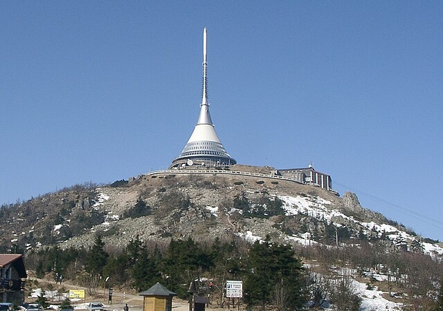
Ještěd mountain, north of the Czech
Republic *Source: photo taken on February 17, 2002 *Author: Bernd Gutte *License: GNU FDL (transwikied from
1253:
955:"}},"text\/plain":{"en":{"P275":"Creative Commons Attribution-ShareAlike 3.0 Unported"}}}}": -->
1278:
236:; with no Invariant Sections, no Front-Cover Texts, and no Back-Cover Texts. A copy of the license is included in the section entitled
208:
1223:
995:
978:
930:
402:
1368:
869:
1298:
1588:
This file contains additional information, probably added from the digital camera or scanner used to create or digitize it.
1558:
1458:
886:
334:
1378:
1338:
1019:
914:
1548:
228:
1333:
1057:
962:
853:
1577:
288:
1403:
1591:
If the file has been modified from its original state, some details may not fully reflect the modified file.
233:
1283:
843:"}},"text\/plain":{"en":{"P180":"Je\u0161t\u011bd"}}}}": -->
440:
1518:
1443:
333:– If you remix, transform, or build upon the material, you must distribute your contributions under the
1233:
1155:
1150:
907:"}},"text\/plain":{"en":{"P6216":"copyrighted"}}}}": -->
1191:
The following pages on the
English Knowledge use this file (pages on other projects are not listed):
61:
736:
703:
686:
669:
652:
639:
614:
602:
572:
559:
542:
516:
499:
486:
461:
57:
53:
47:
445:
114:
106:
1528:
1398:
74:
1178:
348:
226:
Permission is granted to copy, distribute and/or modify this document under the terms of the
188:
1388:
1478:
285:
1513:
8:
1624:
1493:
1358:
1483:
1563:
1273:
1174:
408:
184:
1200:
101:
1263:
794:
782:
766:
753:
585:
528:
Mynydd Ještěd yn y
Weriniaeth Tsiec. Mae gwesty a thrawsyrrydd ar gopa'r mynydd.
1363:
778:
699:
665:
538:
512:
426:
153:
1166:
1125:
1120:
798:
732:
716:
682:
598:
555:
482:
457:
65:
42:
1373:
1136:
1206:
User:Mike Rosoft/List of national cultural monuments of the Czech
Republic
1639:
1195:
720:
1067:
1029:
989:
972:
924:
880:
863:
1543:
215:
1523:
1468:
1093:
Click on a date/time to view the file as it appeared at that time.
1538:
1308:
1448:
394:
1408:
1323:
347:
This licensing tag was added to this file as part of the GFDL
1488:
1433:
1348:
545:. Es befindet sich eine Antenne und ein Hotel auf dem Gipfel.
387:
50° 43′ 56″ N, 14° 59′ 06.97″ E
1423:
1318:
1353:
173:
89:
825:
Add a one-line explanation of what this file represents
689:. No topo da montanha existe um transmissor e um hotel.
672:. Na szczycie znajduje się hotel oraz stacja nadawcza.
625:
Deversorium et instrumentum emissorium ad cacumen sunt.
1444:
Anexo:Patrimonio de la
Humanidad en la República Checa
588:, un relais hertzien et un hôtel en occupent le sommet
79:(1,449 × 1,018 pixels, file size: 1.19 MB, MIME type:
1428:
1243:
1189:
1569:Չեխիայում ՅՈՒՆԵՍԿՕ-ի Համաշխարհային ժառանգության ցանկ
1503:
1418:
1214:
1091:
996:
Creative
Commons Attribution-ShareAlike 3.0 Unported
979:
953:
Creative
Commons Attribution-ShareAlike 3.0 Unported
949:
232:, Version 1.2 or any later version published by the
113:
Commons is a freely licensed media file repository.
1369:
Seznam národních kulturních památek České republiky
1294:Списък на обекти на световното наследство в Чехия
562:. There is a transmitter and a hotel at the top.
502:. Un adkaser hag ul leti zo war al lein anezhañ.
464:. There is a transmitter and a hotel at the top.
1389:Liste der Nationalen Kulturdenkmale Tschechiens
756:. На вершине находится передатчик и гостиница.
354:http://creativecommons.org/licenses/by-sa/3.0/
94:
1379:Seznam vrcholů v Ještědsko-kozákovském hřbetu
267:
203:
169:
131:
1549:Csehország javasolt világörökségi helyszínei
769:บนยอดเขามีสายอากาศส่งสัญญาณและโรงแรมตั้งอยู่
642:met een transmitter en een hotel op de top.
360:Creative Commons Attribution-Share Alike 3.0
195:
179:
164:Ještěd mountain, north of the Czech Republic
14:
310:– to copy, distribute and transmit the work
431:
1479:Wikipédia:Image du jour/19 septembre 2005
1216:The following other wikis use this file:
739:. Vuoren huipulla on TV-torni ja hotelli.
605:. Hai un transmisor e un hotel no cumio.
1494:Liste du patrimoine mondial en Tchéquie
575:. Hay una antena y un hotel en la cima.
489:. Bi ha una entena y un otel en a tuca.
1519:Předłoha:Infokašćik hora/Dokumentacija
1484:Wikipédia:Image du jour/septembre 2005
1404:Pśedłoga:Infokašćik góra/Dokumentacija
401:View this and other nearby images on:
156:nahe Reichenberg im Norden Tschechiens
125:
377:
289:Attribution-Share Alike 3.0 Unported
262:
244:http://www.gnu.org/copyleft/fdl.html
1143:one degree counterclockwise rotated
1084:
278:
273:
13:
1586:
830:
824:
787:
771:
758:
741:
725:
708:
691:
674:
657:
655:med radiomast og hotell på toppen.
644:
627:
607:
590:
577:
564:
547:
530:
521:
504:
491:
474:
450:
158:
146:
138:
126:
72:
1656:
1593:
829:
706:. Na vrchole je vysielač a hotel.
1190:
1020:coordinates of the point of view
1010:coordinates of the point of view
815:
723:. Na vrhu sta oddajnik in hotel.
519:. Na vrcholu je vysílač a hotel.
430:
407:
393:
321:Under the following conditions:
284:This file is licensed under the
277:
272:
266:
220:
219:
93:
31:
21:
812:
451:
159:
1529:Předłoha:Infokašćik hora/testy
1211:
1088:
811:
448:. It was captioned as follows:
250:GNU Free Documentation License
239:GNU Free Documentation License
229:GNU Free Documentation License
147:
26:
1:
1035:50°43'55.999"N, 14°59'6.972"E
139:
36:
1186:
849:Items portrayed in this file
7:
1583:
1510:Usage on hsb.wikipedia.org
1395:Usage on dsb.wikipedia.org
1315:Usage on ceb.wikipedia.org
1250:Usage on azb.wikipedia.org
1240:Usage on ast.wikipedia.org
1230:Usage on arz.wikipedia.org
438:This image was selected as
10:
1661:
1555:Usage on hy.wikipedia.org
1535:Usage on hu.wikipedia.org
1500:Usage on hr.wikipedia.org
1475:Usage on fr.wikipedia.org
1465:Usage on fi.wikipedia.org
1455:Usage on fa.wikipedia.org
1440:Usage on es.wikipedia.org
1415:Usage on eo.wikipedia.org
1385:Usage on de.wikipedia.org
1345:Usage on cs.wikipedia.org
1330:Usage on ce.wikipedia.org
1305:Usage on ca.wikipedia.org
1290:Usage on bg.wikipedia.org
1269:Эльбскія Пясчанікавыя горы
1260:Usage on be.wikipedia.org
1220:Usage on ar.wikipedia.org
335:same or compatible license
128:
1631:File change date and time
1085:
788:
772:
759:
742:
726:
709:
692:
675:
658:
645:
628:
608:
591:
578:
565:
548:
531:
522:
505:
492:
475:
444:on Wikimedia Commons for
420:
293:
265:
16:
1514:Předłoha:Infokašćik hora
1399:Pśedłoga:Infokašćik góra
1364:Seznam tisícovek v Česku
1359:Ještěd (hotel a vysílač)
814:
437:
234:Free Software Foundation
100:This is a file from the
41:
1634:10:23, 1 September 2011
1172:
1142:
1121:08:31, 1 September 2011
172:
104:. Information from its
837:Je\u0161t\u011bd Tower
413:50.732222; 14.985270
107:description page there
46:Size of this preview:
1605:Horizontal resolution
1179:de:Benutzer:Zaufatsch
189:de:Benutzer:Zaufatsch
1374:Koruna českých Sudet
1309:Districte de Liberec
1177:, original uploader
187:, original uploader
66:1,449 × 1,018 pixels
1625:Adobe Photoshop 7.0
1613:Vertical resolution
1449:Distrito de Liberec
1151:09:47, 5 April 2005
737:Tšekin tasavallassa
571:Monte Ještěd en la
316:– to adapt the work
52:Other resolutions:
670:Republice Czeskiej
586:République tchèque
584:Le mont Ještěd en
441:picture of the day
183:(transwikied from
62:1,024 × 719 pixels
1648:
1647:
1578:more global usage
1279:Шаблон:Горы Чэхіі
1212:Global file usage
1184:
963:copyright license
945:copyright license
823:
809:
808:
651:Fjellet Ještěd i
446:19 September 2005
418:
417:
375:
374:
371:
370:
261:
260:
212:
209:Reusing this file
122:
121:
102:Wikimedia Commons
32:Global file usage
1652:
1594:
1539:Libereci kerület
1254:لیبرتس بؤلگهسی
1163:
1133:
1095:
1073:17 February 2002
915:copyright status
901:copyright status
841:Je\u0161t\u011bd
821:
801:,山顶有一座电视发射塔和一个旅店
793:
777:
764:
747:
731:
714:
697:
680:
663:
650:
633:
613:
596:
583:
570:
553:
536:
527:
510:
498:Menez Ještěd er
497:
480:
470:
469:Other languages:
455:
434:
433:
427:
414:
411:
397:
396:
390:
389:
378:
367:
364:
361:
358:
355:
352:
349:licensing update
337:as the original.
286:Creative Commons
281:
280:
276:
275:
270:
269:
263:
257:
254:
251:
248:
245:
223:
222:
216:
206:
175:
174:17 February 2002
163:
151:
143:
135:
129:
118:
97:
96:
90:
84:
82:
69:
58:640 × 450 pixels
54:320 × 225 pixels
48:800 × 562 pixels
1660:
1659:
1655:
1654:
1653:
1651:
1650:
1649:
1582:
1424:Regiono Liberec
1339:Либерец (кӀошт)
1299:Окръзи на Чехия
1224:مقاطعة ليبيريتس
1210:
1192:
1185:
1169:
1161:
1139:
1131:
1087:
1086:
1083:
1082:
1081:
1080:
1079:
1078:
1077:
1076:
1074:
1064:
1063:
1062:
1060:
1045:
1044:
1043:
1042:
1041:
1040:
1039:
1038:
1036:
1026:
1025:
1024:
1022:
1007:
1006:
1005:
1004:
1003:
1002:
1001:
1000:
998:
987:
986:
985:
984:
983:
981:
969:
968:
967:
965:
942:
941:
940:
939:
938:
937:
936:
935:
933:
921:
920:
919:
917:
898:
897:
896:
895:
894:
893:
892:
891:
889:
878:
877:
876:
875:
874:
872:
860:
859:
858:
856:
828:
827:
826:
805:
804:
803:
802:
791:
786:
775:
770:
765:ยอดเขาเย็ชเทดใน
762:
757:
745:
740:
729:
724:
712:
707:
695:
690:
687:República Checa
678:
673:
661:
656:
648:
643:
631:
626:
611:
606:
603:República Checa
594:
589:
581:
576:
573:República Checa
568:
563:
551:
546:
534:
529:
525:
520:
508:
503:
495:
490:
487:Republica Checa
478:
471:
468:
465:
449:
423:
412:
385:
384:
381:Camera location
376:
365:
362:
359:
356:
353:
346:
255:
252:
249:
246:
243:
165:
157:
145:
133:
124:
123:
112:
111:
110:is shown below.
86:
80:
78:
71:
70:
51:
12:
11:
5:
1658:
1646:
1645:
1642:
1636:
1635:
1632:
1628:
1627:
1622:
1618:
1617:
1614:
1610:
1609:
1606:
1602:
1601:
1598:
1585:
1580:of this file.
1574:
1573:
1572:
1571:
1566:
1561:
1559:Լիբերեցի շրջան
1553:
1552:
1551:
1546:
1544:Libereci járás
1541:
1533:
1532:
1531:
1526:
1521:
1516:
1508:
1507:
1506:
1498:
1497:
1496:
1491:
1486:
1481:
1473:
1472:
1471:
1463:
1462:
1461:
1459:شهرستان لیبرتس
1453:
1452:
1451:
1446:
1438:
1437:
1436:
1431:
1426:
1421:
1413:
1412:
1411:
1406:
1401:
1393:
1392:
1391:
1383:
1382:
1381:
1376:
1371:
1366:
1361:
1356:
1351:
1343:
1342:
1341:
1336:
1328:
1327:
1326:
1321:
1313:
1312:
1311:
1303:
1302:
1301:
1296:
1288:
1287:
1286:
1281:
1276:
1271:
1266:
1258:
1257:
1256:
1248:
1247:
1246:
1238:
1237:
1236:
1228:
1227:
1226:
1213:
1209:
1208:
1203:
1198:
1188:
1183:
1182:
1171:
1167:
1164:
1160:1,467 × 1,044
1158:
1153:
1148:
1145:
1144:
1141:
1137:
1134:
1130:1,449 × 1,018
1128:
1123:
1118:
1114:
1113:
1110:
1107:
1104:
1101:
1098:
1090:
1075:
1072:
1070:
1069:
1068:
1066:
1065:
1061:
1056:
1054:
1053:
1052:
1051:
1049:
1037:
1034:
1032:
1031:
1030:
1028:
1027:
1023:
1018:
1016:
1015:
1014:
1013:
1011:
999:
994:
992:
991:
990:
988:
982:
977:
975:
974:
973:
971:
970:
966:
961:
959:
958:
957:
956:
954:
950:
946:
934:
929:
927:
926:
925:
923:
922:
918:
913:
911:
910:
909:
908:
906:
902:
890:
885:
883:
882:
881:
879:
873:
868:
866:
865:
864:
862:
861:
857:
852:
850:
847:
846:
845:
844:
842:
838:
834:
820:
819:
816:
813:
807:
806:
789:
781:山頂にあるテレビ塔とホテル(
773:
760:
743:
727:
710:
693:
676:
659:
646:
629:
609:
592:
579:
566:
560:Czech Republic
549:
532:
523:
506:
500:Republik Tchek
493:
476:
473:
472:
467:
466:
462:Czech Republic
435:
422:
419:
416:
415:
405:
399:
382:
373:
372:
369:
368:
343:
342:
341:
340:
339:
338:
328:
319:
318:
317:
311:
304:You are free:
299:
298:
295:
294:
292:
282:
259:
258:
224:
213:
201:
200:
197:
193:
192:
181:
177:
176:
171:
167:
166:
136:
127:
120:
119:
98:
88:
87:
45:
40:
39:
34:
29:
24:
19:
9:
6:
4:
3:
2:
1657:
1643:
1641:
1638:
1637:
1633:
1630:
1629:
1626:
1623:
1621:Software used
1620:
1619:
1615:
1612:
1611:
1607:
1604:
1603:
1599:
1596:
1595:
1592:
1589:
1581:
1579:
1570:
1567:
1565:
1562:
1560:
1557:
1556:
1554:
1550:
1547:
1545:
1542:
1540:
1537:
1536:
1534:
1530:
1527:
1525:
1522:
1520:
1517:
1515:
1512:
1511:
1509:
1505:
1502:
1501:
1499:
1495:
1492:
1490:
1487:
1485:
1482:
1480:
1477:
1476:
1474:
1470:
1467:
1466:
1464:
1460:
1457:
1456:
1454:
1450:
1447:
1445:
1442:
1441:
1439:
1435:
1432:
1430:
1427:
1425:
1422:
1420:
1417:
1416:
1414:
1410:
1407:
1405:
1402:
1400:
1397:
1396:
1394:
1390:
1387:
1386:
1384:
1380:
1377:
1375:
1372:
1370:
1367:
1365:
1362:
1360:
1357:
1355:
1354:Okres Liberec
1352:
1350:
1347:
1346:
1344:
1340:
1337:
1335:
1334:Чехин кӀошташ
1332:
1331:
1329:
1325:
1322:
1320:
1319:Okres Liberec
1317:
1316:
1314:
1310:
1307:
1306:
1304:
1300:
1297:
1295:
1292:
1291:
1289:
1285:
1282:
1280:
1277:
1275:
1272:
1270:
1267:
1265:
1262:
1261:
1259:
1255:
1252:
1251:
1249:
1245:
1242:
1241:
1239:
1235:
1232:
1231:
1229:
1225:
1222:
1221:
1219:
1218:
1217:
1207:
1204:
1202:
1199:
1197:
1194:
1193:
1180:
1176:
1170:
1165:
1159:
1157:
1154:
1152:
1149:
1147:
1146:
1140:
1135:
1129:
1127:
1124:
1122:
1119:
1116:
1115:
1111:
1108:
1105:
1102:
1099:
1097:
1096:
1094:
1071:
1059:
1055:
1033:
1021:
1017:
997:
993:
980:
976:
964:
960:
932:
928:
916:
912:
888:
884:
871:
867:
855:
851:
848:
817:
810:
800:
796:
784:
780:
768:
767:สาธารณรัฐเช็ก
755:
751:
738:
734:
722:
718:
705:
701:
688:
684:
671:
667:
654:
647:Norsk nynorsk
641:
637:
624:
620:
616:
604:
600:
587:
574:
561:
557:
544:
540:
518:
514:
501:
488:
484:
463:
459:
454:
447:
443:
442:
436:
429:
428:
425:
410:
406:
404:
403:OpenStreetMap
400:
398:
388:
383:
380:
379:
350:
345:
344:
336:
332:
329:
326:
323:
322:
320:
315:
312:
309:
306:
305:
303:
302:
301:
300:
297:
296:
290:
287:
283:
271:
264:
241:
240:
235:
231:
230:
225:
218:
217:
214:
210:
205:
202:
198:
194:
190:
186:
182:
178:
168:
162:
155:
150:
142:
137:
130:
116:
109:
108:
103:
99:
92:
91:
85:
76:
75:Original file
67:
63:
59:
55:
49:
44:
38:
35:
33:
30:
28:
25:
23:
20:
18:
15:
1644:Uncalibrated
1590:
1587:
1575:
1469:Ještěd-torni
1215:
1201:Ještěd Tower
1092:
1089:File history
870:Ještěd Tower
681:Montanha de
635:
622:
618:
617:mons nomine
452:
439:
424:
357:CC BY-SA 3.0
330:
324:
313:
307:
237:
227:
160:
148:
140:
115:You can help
105:
73:
22:File history
1640:Color space
1597:Orientation
1284:Рудныя горы
1181:) {{GFDL}}
931:copyrighted
905:copyrighted
711:Slovenščina
331:share alike
325:attribution
199:Bernd Gutte
144:Hora Ještěd
132:Description
1234:جبل چيستيد
1187:File usage
1106:Dimensions
694:Slovenčina
630:Nederlands
623:Jeschken).
621:(Germanis
543:Tschechien
204:Permission
134:Jested.jpg
81:image/jpeg
27:File usage
1132:(1.19 MB)
1103:Thumbnail
1100:Date/Time
1058:inception
1048:inception
677:Português
554:Mountain
494:Brezhoneg
456:Mountain
453:English:
291:license.
161:English:
149:Deutsch:
141:Čeština:
1584:Metadata
1429:IJK 2009
1168:Mormegil
1162:(786 KB)
818:Captions
653:Tsjekkia
640:Tsjechië
634:De berg
615:Bohemiae
580:Français
481:Montaña
477:Aragonés
314:to remix
308:to share
154:Jeschken
37:Metadata
1564:Լիբերեց
1504:Liberec
1419:Liberec
1274:Ліберац
1244:Liberec
1138:Lindi44
1117:current
1112:Comment
854:depicts
833:depicts
822:English
779:イェシュチェド
744:Русский
735:-vuori
704:Čechách
597:Mounte
567:Español
558:in the
550:English
533:Deutsch
524:Cymraeg
507:Čeština
460:in the
77:
1616:20 dpi
1608:20 dpi
1600:Normal
1524:Jěšćed
1489:Ještěd
1434:Ještěd
1409:Ještěd
1349:Ještěd
1324:Ještěd
1264:Шумава
1196:Ještěd
887:Ještěd
750:Йештед
733:Ještěd
721:Češkem
717:Ještěd
700:Ještěd
683:Ještěd
666:Ještěd
660:Polski
636:Ještěd
619:Ještěd
610:Latina
599:Ještěd
593:Galego
556:Ještěd
539:Ještěd
513:Ještěd
483:Ještěd
458:Ještěd
421:Awards
391:
196:Author
180:Source
1576:View
754:Чехии
748:Гора
728:Suomi
715:Gora
698:Hora
664:Góra
537:Berg
517:Česku
511:Hora
485:en a
1109:User
799:捷斯台山
366:true
363:true
256:true
253:true
247:GFDL
170:Date
152:Der
17:File
1175:de:
783:チェコ
774:日本語
761:ไทย
719:na
685:na
638:in
601:na
541:in
185:de:
795:捷克
790:中文
752:в
746::
730::
713::
702:v
696::
679::
668:w
662::
649::
632::
612::
595::
582::
569::
552::
535::
526::
515:v
509::
496::
479::
64:|
60:|
56:|
50:.
797:的
792::
785:)
776::
763::
351:.
242:.
211:)
207:(
191:)
117:.
83:)
68:.
Text is available under the Creative Commons Attribution-ShareAlike License. Additional terms may apply.
