38:
805:"}},"text\/plain":{"en":{"":"inception"}}},"{\"value\":{\"time\":\"+2009-03-02T00:00:00Z\",\"timezone\":0,\"before\":0,\"after\":0,\"precision\":11,\"calendarmodel\":\"http:\\\/\\\/www.wikidata.org\\\/entity\\\/Q1985727\"},\"type\":\"time\"}":{"text\/html":{"en":{"P571":"2 March 2009"}},"text\/plain":{"en":{"P571":"2 March 2009"}}}}": -->
435:
562:
446:
574:","P2093":"Kbh3rd"}},"text\/plain":{"en":{"P4174":"Kbh3rd","P2093":"Kbh3rd"}}},"{\"value\":{\"entity-type\":\"property\",\"numeric-id\":2093,\"id\":\"P2093\"},\"type\":\"wikibase-entityid\"}":{"text\/html":{"en":{"":"
94:
843:"}},"text\/plain":{"en":{"":"media type"}}},"{\"value\":\"image\\\/svg+xml\",\"type\":\"string\"}":{"text\/html":{"en":{"P1163":"image\/svg+xml"}},"text\/plain":{"en":{"P1163":"image\/svg+xml"}}}}": -->
717:"}},"text\/plain":{"en":{"":"copyright license"}}},"{\"value\":{\"entity-type\":\"item\",\"numeric-id\":14946043,\"id\":\"Q14946043\"},\"type\":\"wikibase-entityid\"}":{"text\/html":{"en":{"P275":"
673:"}},"text\/plain":{"en":{"":"copyright status"}}},"{\"value\":{\"entity-type\":\"item\",\"numeric-id\":50423863,\"id\":\"Q50423863\"},\"type\":\"wikibase-entityid\"}":{"text\/html":{"en":{"P6216":"
761:"}},"text\/plain":{"en":{"":"source of file"}}},"{\"value\":{\"entity-type\":\"item\",\"numeric-id\":66458942,\"id\":\"Q66458942\"},\"type\":\"wikibase-entityid\"}":{"text\/html":{"en":{"P7482":"
578:"}},"text\/plain":{"en":{"":"author name string"}}},"{\"value\":{\"entity-type\":\"property\",\"numeric-id\":2699,\"id\":\"P2699\"},\"type\":\"wikibase-entityid\"}":{"text\/html":{"en":{"":"
980:
949:
566:"}},"text\/plain":{"en":{"":"creator"}}},"{\"value\":{\"entity-type\":\"property\",\"numeric-id\":4174,\"id\":\"P4174\"},\"type\":\"wikibase-entityid\"}":{"text\/html":{"en":{"":"
839:
919:
247:
Data were drawn from
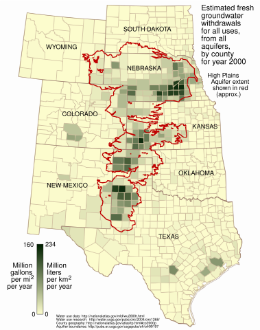
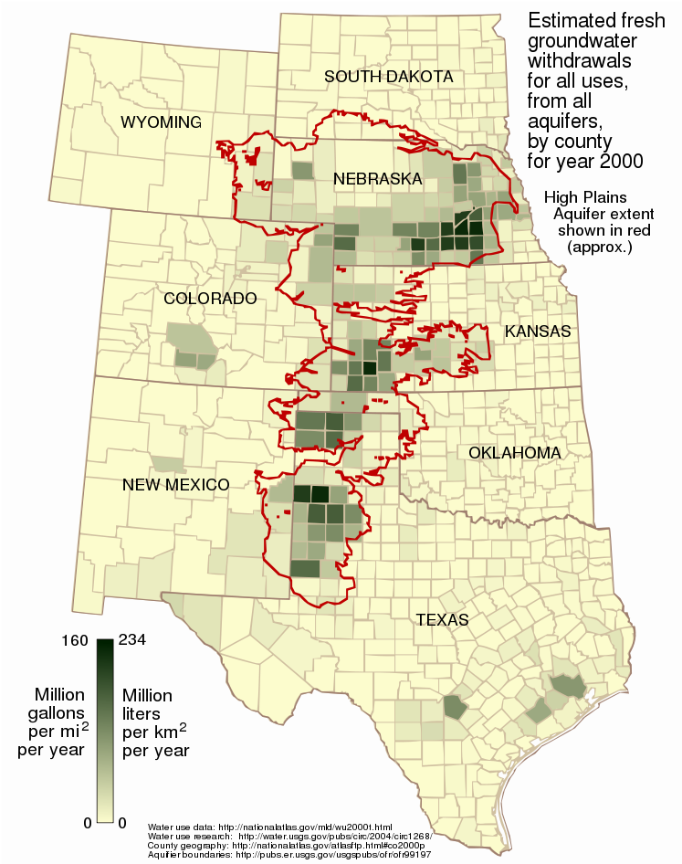
Circular 1268 which serves as one of the few sources of information about regional or national trends in water withdrawals. Circular 1268 provides information on eight categories of water use: public supply, domestic, irrigation, livestock, aquaculture, industrial, mining, and
582:"}},"text\/plain":{"en":{"":"URL"}}},"{\"value\":\"https:\\\/\\\/commons.wikimedia.org\\\/wiki\\\/user:Kbh3rd\",\"type\":\"string\"}":{"text\/html":{"en":{"P2699":"
272:
The estimated total ground water withdrawals of fresh water for all categories, in millions of gallons per day. Totals may include null values (unknowns) for domestic, livestock, or mining use. These categories generally represent negligible amounts of water use for a
570:"}},"text\/plain":{"en":{"":"Wikimedia username"}}},"{\"value\":\"Kbh3rd\",\"type\":\"string\"}":{"text\/html":{"en":{"P4174":"
1118:
487:– You must give appropriate credit, provide a link to the license, and indicate if changes were made. You may do so in any reasonable manner, but not in any way that suggests the licensor endorses you or your use.
966:
The map said "acre" while the data, as noted on the image description page, correctly said "square mile". I have fixed that and made some minor esthetic adjustments of the state name
571:
412:
762:
718:
674:
997:{{Information |Description={{en|1=This map shows the estimated fresh water usage per square mile in the year 2000 for counties in the eight states underlain in part by the
64:
583:
68:
60:
56:
52:
48:
42:
840:
758:
670:
579:
575:
567:
802:
714:
563:
105:
77:
154:
Usage is for all purposes -- public supply, industrial, irrigation, mining, livestock, and thermoelectric power -- from all underground sources,
1053:
721:"}},"text\/plain":{"en":{"P275":"Creative Commons Attribution-ShareAlike 3.0 Unported"}}}}": -->
586:"}},"text\/plain":{"en":{"P2699":"https:\/\/commons.wikimedia.org\/wiki\/user:Kbh3rd"}}}}": -->
285:
The data is supplied as million gallons per day, by county. To arrive at an annual amount per square mile per year, the usage value from
148:
This map shows the estimated fresh water usage per square mile in the year 2000 for counties in the eight states underlain in part by the
979:
974:
948:
943:
363:
788:
744:
700:
1025:
367:
494:
850:
772:
684:
648:
635:
620:
765:"}},"text\/plain":{"en":{"P7482":"original creation by uploader"}}}}": -->
1138:
812:
728:
593:
552:
1078:
918:
913:
456:
37:
627:
1168:
1148:
289:
was multiplied by 365 and divided by the number of square miles in the county as given in the 2000 county
493:– If you remix, transform, or build upon the material, you must distribute your contributions under the
229:
168:
677:"}},"text\/plain":{"en":{"P6216":"copyrighted"}}}}": -->
1011:
The following pages on the
English Knowledge use this file (pages on other projects are not listed):
165:
113:
655:
453:
8:
152:, presented as million gallons per square mile and million liters per square kilometer.
1035:
149:
100:
542:
428:
I, the copyright holder of this work, hereby publish it under the following license:
1030:
998:
249:
358:
371:
1088:
373:), the central meridian and latitude of which align nicely with the aquifer.
1015:
402:
1020:
990:
959:
929:
860:
822:
782:
738:
694:
603:
348:
290:
1068:
1128:
171:
230:
http://nationalatlas.gov/atlasftp.html?openChapters=chpwater#chpwater
886:
Click on a date/time to view the file as it appeared at that time.
413:
File:Ogallala area freshwater ground withdrawals all aquifers.png
161:
Water usage data for the year 2000 was taken from the datafile
183:
U.S. Geological Survey, Water
Resources of the United States
248:
thermoelectric power. The complete report can be found at
82:(SVG file, nominally 747 × 946 pixels, file size: 1.48 MB)
1063:
382:
88:
536:
Add a one-line explanation of what this file represents
1099:Жер астындағы суды өндірістік мұқтаждар үшін пайдалану
1108:
1009:
1158:
1044:
884:
745:
Creative
Commons Attribution-ShareAlike 3.0 Unported
719:
Creative
Commons Attribution-ShareAlike 3.0 Unported
112:
Commons is a freely licensed media file repository.
584:https:\/\/commons.wikimedia.org\/wiki\/user:Kbh3rd
357:Aquifer boundaries taken from Fischer and McGuire
195:Estimated Use of Water in the United States, 2000
504:https://creativecommons.org/licenses/by-sa/3.0
250:http://water.usgs.gov/pubs/circ/2004/circ1268/
93:
510:Creative Commons Attribution-Share Alike 3.0
434:
378:
257:The attribute used in this map is described:
135:
408:
398:
388:
138:High plains fresh groundwater usage 2000.svg
14:
470:– to copy, distribute and transmit the work
320:2000 County Boundaries of the United States
41:Size of this PNG preview of this SVG file:
1046:The following other wikis use this file:
656:https://commons.wikimedia.org/user:Kbh3rd
364:Lambert azimuthal equal-area projection
936:corrected metric conversion - see talk
349:http://nationalatlas.gov/atlasftp.html
1026:List of aquifers in the United States
124:
457:Attribution-Share Alike 3.0 Unported
877:
445:
440:
337:National Atlas of the United States
308:National Atlas of the United States
279:National Atlas of the United States
218:National Atlas of the United States
13:
541:
535:
431:
427:
142:
125:
75:
1182:
540:
198:Geospatial_Data_Presentation_Form
170:. Citation information from the
1010:
526:
481:Under the following conditions:
452:This file is licensed under the
444:
439:
433:
158:just from the Ogallala Aquifer.
92:
31:
21:
1089:Grutte Flakten (Noard-Amearika)
523:
143:
1041:
999:High Plains (Ogallala) Aquifer
881:
522:
150:High Plains (Ogallala) Aquifer
26:
1:
789:original creation by uploader
763:original creation by uploader
1006:
1001:, presented as million milli
548:Items portrayed in this file
421:
7:
1075:Usage on ckb.wikipedia.org
276:Attribute_Definition_Source
10:
1187:
1165:Usage on zh.wikipedia.org
1155:Usage on www.wikidata.org
1145:Usage on vi.wikipedia.org
1135:Usage on sr.wikipedia.org
1125:Usage on pt.wikipedia.org
1115:Usage on ml.wikipedia.org
1105:Usage on kw.wikipedia.org
1095:Usage on kk.wikipedia.org
1085:Usage on fy.wikipedia.org
1069:Usuari:Vallue/Great Plains
1060:Usage on ca.wikipedia.org
1050:Usage on ar.wikipedia.org
495:same or compatible license
362:The map is presented in a
167:from the US National Atlas
132:
127:
878:
392:
296:from the National Atlas:
16:
525:
461:
244:Supplemental_Information
99:This is a file from the
36:
996:
965:
935:
381:
323:Publication_Information
204:Publication_Information
103:. Information from its
1149:Đại Bình nguyên Bắc Mỹ
106:description page there
1129:Aquífero de Ogallala
1119:ഒഗാല്ലല ഭൂഗർഭജലശേഖരം
300:Citation_Information
269:Attribute_Definition
65:1,617 × 2,048 pixels
975:23:40, 2 March 2009
944:01:28, 3 March 2009
914:23:13, 9 March 2009
476:– to adapt the work
47:Other resolutions:
1054:خزان أوجالا الجوفي
1036:User:Kbh3rd/Images
636:author name string
621:Wikimedia username
576:author name string
568:Wikimedia username
61:808 × 1,024 pixels
1042:Global file usage
1004:
729:copyright license
715:copyright license
534:
418:
417:
328:Publication_Place
209:Publication_Place
121:
120:
101:Wikimedia Commons
32:Global file usage
1178:
1031:Ogallala Aquifer
987:
956:
926:
888:
685:copyright status
671:copyright status
658:
653:
643:
640:
630:
625:
532:
517:
514:
511:
508:
505:
497:as the original.
454:Creative Commons
448:
447:
443:
442:
437:
436:
394:
384:
311:Publication_Date
186:Publication_Date
147:
139:
133:
117:
96:
95:
89:
83:
72:
69:747 × 946 pixels
57:606 × 768 pixels
53:379 × 480 pixels
49:189 × 240 pixels
43:473 × 599 pixels
1186:
1185:
1181:
1180:
1179:
1177:
1176:
1175:
1040:
1012:
1005:
993:
985:
962:
954:
932:
924:
880:
879:
876:
875:
874:
873:
872:
871:
870:
869:
867:
857:
856:
855:
853:
838:
837:
836:
835:
834:
833:
832:
831:
829:
819:
818:
817:
815:
800:
799:
798:
797:
796:
795:
794:
793:
791:
779:
778:
777:
775:
756:
755:
754:
753:
752:
751:
750:
749:
747:
735:
734:
733:
731:
712:
711:
710:
709:
708:
707:
706:
705:
703:
691:
690:
689:
687:
668:
667:
666:
665:
664:
663:
662:
661:
660:
659:
654:
651:
645:
644:
641:
638:
632:
631:
626:
623:
614:
613:
612:
610:
600:
599:
598:
596:
561:
560:
559:
558:
557:
555:
539:
538:
537:
520:
519:
518:
515:
512:
509:
506:
503:
502:
460:
449:
430:
429:
424:
419:
374:
366:as used in the
263:Attribute_Label
174:for that file:
137:
130:
123:
122:
111:
110:
109:is shown below.
85:
81:
74:
73:
46:
12:
11:
5:
1184:
1174:
1173:
1172:
1171:
1163:
1162:
1161:
1153:
1152:
1151:
1143:
1142:
1141:
1133:
1132:
1131:
1123:
1122:
1121:
1113:
1112:
1111:
1103:
1102:
1101:
1093:
1092:
1091:
1083:
1082:
1081:
1073:
1072:
1071:
1066:
1058:
1057:
1056:
1043:
1039:
1038:
1033:
1028:
1023:
1018:
1008:
1003:
1002:
995:
991:
988:
982:
977:
972:
969:
968:
964:
960:
957:
951:
946:
941:
938:
937:
934:
930:
927:
921:
916:
911:
907:
906:
903:
900:
897:
894:
891:
883:
868:
865:
863:
862:
861:
859:
858:
854:
849:
847:
846:
845:
844:
842:
830:
827:
825:
824:
823:
821:
820:
816:
811:
809:
808:
807:
806:
804:
792:
787:
785:
784:
783:
781:
780:
776:
773:source of file
771:
769:
768:
767:
766:
764:
760:
759:source of file
748:
743:
741:
740:
739:
737:
736:
732:
727:
725:
724:
723:
722:
720:
716:
704:
699:
697:
696:
695:
693:
692:
688:
683:
681:
680:
679:
678:
676:
672:
647:
646:
634:
633:
619:
618:
617:
616:
615:
611:
608:
606:
605:
604:
602:
601:
597:
592:
590:
589:
588:
587:
585:
581:
577:
573:
569:
565:
556:
551:
549:
546:
545:
544:
543:
531:
530:
527:
524:
501:
500:
499:
498:
488:
479:
478:
477:
471:
464:You are free:
451:
450:
432:
426:
425:
423:
420:
416:
415:
410:
409:Other versions
406:
405:
400:
396:
395:
390:
386:
385:
380:
376:
375:
368:National Atlas
355:
354:
353:
352:
345:
344:Online_Linkage
341:
340:
339:
338:
335:
332:
329:
324:
321:
318:
315:
312:
309:
306:
301:
283:
282:
281:
280:
277:
274:
270:
267:
264:
255:
254:
253:
252:
245:
238:Additionally:
236:
235:
234:
233:
226:
225:Online_Linkage
222:
221:
220:
219:
216:
213:
210:
205:
202:
199:
196:
193:
190:
187:
184:
181:
140:
131:
129:
126:
119:
118:
97:
87:
86:
40:
35:
34:
29:
24:
19:
9:
6:
4:
3:
2:
1183:
1170:
1167:
1166:
1164:
1160:
1157:
1156:
1154:
1150:
1147:
1146:
1144:
1140:
1139:Подземне воде
1137:
1136:
1134:
1130:
1127:
1126:
1124:
1120:
1117:
1116:
1114:
1110:
1107:
1106:
1104:
1100:
1097:
1096:
1094:
1090:
1087:
1086:
1084:
1080:
1077:
1076:
1074:
1070:
1067:
1065:
1062:
1061:
1059:
1055:
1052:
1051:
1049:
1048:
1047:
1037:
1034:
1032:
1029:
1027:
1024:
1022:
1019:
1017:
1014:
1013:
1000:
994:
989:
983:
981:
978:
976:
973:
971:
970:
963:
958:
952:
950:
947:
945:
942:
940:
939:
933:
928:
922:
920:
917:
915:
912:
909:
908:
904:
901:
898:
895:
892:
890:
889:
887:
866:image/svg+xml
864:
852:
848:
826:
814:
810:
790:
786:
774:
770:
746:
742:
730:
726:
702:
698:
686:
682:
657:
650:
637:
629:
622:
607:
595:
591:
554:
550:
547:
528:
521:
507:CC BY-SA 3.0
496:
492:
489:
486:
483:
482:
480:
475:
472:
469:
466:
465:
463:
462:
458:
455:
438:
414:
411:
407:
404:
401:
397:
391:
387:
377:
372:
369:
365:
361:
359:
350:
346:
343:
342:
336:
333:
330:
327:
326:
325:
322:
319:
316:
313:
310:
307:
304:
303:
302:
299:
298:
297:
295:
292:
288:
278:
275:
271:
268:
265:
262:
261:
260:
259:
258:
251:
246:
243:
242:
241:
240:
239:
231:
227:
224:
223:
217:
214:
211:
208:
207:
206:
203:
200:
197:
194:
191:
188:
185:
182:
179:
178:
177:
176:
175:
173:
169:
166:
164:
159:
157:
151:
146:
141:
134:
115:
108:
107:
102:
98:
91:
90:
84:
79:
78:Original file
70:
66:
62:
58:
54:
50:
44:
39:
33:
30:
28:
25:
23:
20:
18:
15:
1079:ئاوی ژێرزەوی
1064:Grans Planes
1045:
1016:Great Plains
885:
882:File history
828:2 March 2009
490:
484:
473:
467:
383:2 March 2009
356:
293:
286:
284:
256:
237:
162:
160:
155:
153:
144:
114:You can help
104:
76:
22:File history
1021:Groundwater
701:copyrighted
675:copyrighted
491:share alike
485:attribution
287:wu2000t.dbf
163:wu2000t.dbf
136:Description
1007:File usage
984:747 × 946
967:locations.
953:747 × 946
923:747 × 946
899:Dimensions
851:media type
841:media type
609:some value
370:(EPSG:2163
331:Reston, VA
305:Originator
294:co2000p020
212:Reston, VA
180:Originator
27:File usage
986:(1.48 MB)
955:(1.48 MB)
925:(1.48 MB)
896:Thumbnail
893:Date/Time
813:inception
803:inception
422:Licensing
334:Publisher
291:shapefile
215:Publisher
145:English:
1109:Dowr dor
529:Captions
474:to remix
468:to share
459:license.
393:Own work
266:To-wgwfr
201:Database
172:metadata
1169:奥加拉拉蓄水层
1159:Q444161
910:current
905:Comment
594:creator
564:creator
553:depicts
533:English
273:county.
128:Summary
80:
992:Kbh3rd
961:Kbh3rd
931:Kbh3rd
642:Kbh3rd
628:Kbh3rd
572:Kbh3rd
403:Kbh3rd
399:Author
389:Source
314:200506
189:200509
317:Title
192:Title
902:User
516:true
513:true
379:Date
351:>
347:<
232:>
228:<
17:File
649:URL
580:URL
156:not
652::
639::
624::
360:.
67:|
63:|
59:|
55:|
51:|
45:.
116:.
71:.
Text is available under the Creative Commons Attribution-ShareAlike License. Additional terms may apply.
