617:"}},"text\/plain":{"en":{"":"checksum"}}},"{\"value\":\"896675eca039da6c6b13bbf5b5cdee4aaf84055b\",\"type\":\"string\"}":{"text\/html":{"en":{"P4092":"896675eca039da6c6b13bbf5b5cdee4aaf84055b"}},"text\/plain":{"en":{"P4092":"896675eca039da6c6b13bbf5b5cdee4aaf84055b"}}},"{\"value\":{\"entity-type\":\"property\",\"numeric-id\":459,\"id\":\"P459\"},\"type\":\"wikibase-entityid\"}":{"text\/html":{"en":{"":"
541:"}},"text\/plain":{"en":{"":"inception"}}},"{\"value\":{\"time\":\"+2010-09-26T00:00:00Z\",\"timezone\":0,\"before\":0,\"after\":0,\"precision\":11,\"calendarmodel\":\"http:\\\/\\\/www.wikidata.org\\\/entity\\\/Q1985727\"},\"type\":\"time\"}":{"text\/html":{"en":{"P571":"26 September 2010"}},"text\/plain":{"en":{"P571":"26 September 2010"}}}}": -->
38:
253:
613:
264:
94:
579:"}},"text\/plain":{"en":{"":"media type"}}},"{\"value\":\"image\\\/svg+xml\",\"type\":\"string\"}":{"text\/html":{"en":{"P1163":"image\/svg+xml"}},"text\/plain":{"en":{"P1163":"image\/svg+xml"}}}}": -->
621:"}},"text\/plain":{"en":{"":"determination method"}}},"{\"value\":{\"entity-type\":\"item\",\"numeric-id\":13414952,\"id\":\"Q13414952\"},\"type\":\"wikibase-entityid\"}":{"text\/html":{"en":{"P459":"
684:"}},"text\/plain":{"en":{"":"data size"}}},"{\"value\":{\"amount\":\"+2150659\",\"unit\":\"http:\\\/\\\/www.wikidata.org\\\/entity\\\/Q8799\"},\"type\":\"quantity\"}":{"text\/html":{"en":{"P3575":"2,150,659
497:"}},"text\/plain":{"en":{"":"copyright license"}}},"{\"value\":{\"entity-type\":\"item\",\"numeric-id\":14946043,\"id\":\"Q14946043\"},\"type\":\"wikibase-entityid\"}":{"text\/html":{"en":{"P275":"
453:"}},"text\/plain":{"en":{"":"copyright status"}}},"{\"value\":{\"entity-type\":\"item\",\"numeric-id\":50423863,\"id\":\"Q50423863\"},\"type\":\"wikibase-entityid\"}":{"text\/html":{"en":{"P6216":"
729:"}},"text\/plain":{"en":{"":"height"}}},"{\"value\":{\"amount\":\"+1345\",\"unit\":\"http:\\\/\\\/www.wikidata.org\\\/entity\\\/Q355198\"},\"type\":\"quantity\"}":{"text\/html":{"en":{"P2048":"1,345
774:"}},"text\/plain":{"en":{"":"width"}}},"{\"value\":{\"amount\":\"+1140\",\"unit\":\"http:\\\/\\\/www.wikidata.org\\\/entity\\\/Q355198\"},\"type\":\"quantity\"}":{"text\/html":{"en":{"P2049":"1,140
389:"}},"text\/plain":{"en":{"P180":"Cumbria"}}},"{\"value\":{\"entity-type\":\"item\",\"numeric-id\":368740,\"id\":\"Q368740\"},\"type\":\"wikibase-entityid\"}":{"text\/html":{"en":{"P180":"
385:"}},"text\/plain":{"en":{"":"depicts"}}},"{\"value\":{\"entity-type\":\"item\",\"numeric-id\":23066,\"id\":\"Q23066\"},\"type\":\"wikibase-entityid\"}":{"text\/html":{"en":{"P180":"
770:
1426:
311:– You must give appropriate credit, provide a link to the license, and indicate if changes were made. You may do so in any reasonable manner, but not in any way that suggests the licensor endorses you or your use.
878:, UK with the following information shown: *Administrative borders *Coastline, lakes and rivers *Roads and railways *Urban areas Equirectangular map projection on WGS 84 datum, with N/S stretched 170
622:
498:
454:
390:
386:
771:
726:
681:
614:
576:
450:
618:
538:
494:
382:
1398:
889:
1690:
501:"}},"text\/plain":{"en":{"P275":"Creative Commons Attribution-ShareAlike 3.0 Unported"}}}}": -->
68:
64:
60:
56:
52:
48:
42:
242:
351:
105:
77:
666:
524:
480:
436:
1356:
318:
419:
785:
740:
695:
632:
586:
464:
971:
659:
548:
508:
403:
1066:
981:
946:
1206:
213:
274:
1141:
1281:
888:
More than 100 pages use this file. The following list shows the first 100 pages that use this file only. A
1416:
688:"}},"text\/plain":{"en":{"P3575":"2,150,659 byte"}}}}": -->
317:– If you remix, transform, or build upon the material, you must distribute your contributions under the
1391:
1161:
1131:
1346:
1011:
778:"}},"text\/plain":{"en":{"P2049":"1,140 pixel"}}}}": -->
733:"}},"text\/plain":{"en":{"P2048":"1,345 pixel"}}}}": -->
457:"}},"text\/plain":{"en":{"P6216":"copyrighted"}}}}": -->
1046:
1376:
1251:
199:
926:
113:
1271:
1121:
1036:
916:
393:"}},"text\/plain":{"en":{"P180":"Millom"}}}}": -->
625:"}},"text\/plain":{"en":{"P459":"SHA-1"}}}}": -->
1246:
961:
951:
911:
856:
851:
37:
1466:
1436:
1086:
271:
8:
1336:
1291:
1331:
1071:
1006:
966:
936:
1301:
1171:
1156:
1111:
1106:
1061:
1031:
1021:
941:
100:
1216:
1136:
1051:
976:
196:
1316:
1256:
1176:
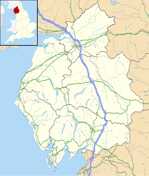
1146:
901:
230:
1326:
1151:
1091:
1076:
1056:
1001:
867:
217:
1366:
1231:
1041:
1371:
1351:
1306:
1226:
1201:
1166:
1101:
795:
750:
705:
642:
596:
558:
518:
474:
430:
413:
1361:
1286:
1221:
1016:
159:
Equirectangular map projection on WGS 84 datum, with N/S stretched 170%
1381:
1321:
1311:
1241:
1236:
1191:
1126:
956:
1621:
1341:
1211:
991:
906:
206:
Administrative borders and coastline data from
Boundary-Line product.
1536:
1261:
1196:
1181:
1096:
1081:
986:
931:
824:
Click on a date/time to view the file as it appeared at that time.
139:
1681:
282:
Contains
Ordnance Survey data © Crown copyright and database right
1486:
1476:
1296:
1276:
1026:
996:
921:
896:
875:
1386:
1186:
1116:
1636:
1566:
1541:
1516:
82:(SVG file, nominally 1,140 × 1,345 pixels, file size: 2.05 MB)
1586:
1551:
1526:
1471:
1511:
1266:
1611:
1481:
185:
88:
1601:
1546:
1671:
1656:
1501:
1676:
1651:
1606:
1576:
1531:
1521:
1506:
1491:
1661:
1646:
1626:
1616:
1581:
1556:
1456:
1446:
886:
1666:
1596:
1591:
1571:
1561:
1496:
1461:
1407:
822:
525:
Creative
Commons Attribution-ShareAlike 3.0 Unported
499:
Creative
Commons Attribution-ShareAlike 3.0 Unported
112:
Commons is a freely licensed media file repository.
1631:
1641:
209:All other geographic data from Meridian 2 product.
328:https://creativecommons.org/licenses/by-sa/3.0
93:
1437:Plantilya:Location map United Kingdom Cumbria
334:Creative Commons Attribution-Share Alike 3.0
252:
237:
181:
130:
347:
226:
191:
14:
775:
730:
685:
294:– to copy, distribute and transmit the work
142:, UK with the following information shown:
41:Size of this PNG preview of this SVG file:
1467:Plantilla:Mapa de localización de Cumbria
1409:The following other wikis use this file:
1417:قالب:Location map United Kingdom Cumbria
648:896675eca039da6c6b13bbf5b5cdee4aaf84055b
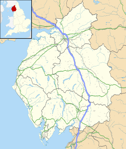
352:File:Cumbria UK district map (blank).svg
124:
1357:Vickers Shipbuilding and Engineering
275:Attribution-Share Alike 3.0 Unported
233:, created using Ordnance Survey data
815:
263:
258:
13:
982:Cark & Cartmel railway station
972:Brampton railway station (Cumbria)
874:{{Information |Description=Map of
380:
374:
249:
125:
75:
1702:
1067:Grange-over-Sands railway station
947:Barrow-in-Furness railway station
379:
1427:Шаблон:ПК Великобритания Къмбрия
365:
305:Under the following conditions:
270:This file is licensed under the
262:
257:
251:
92:
31:
21:
362:
1404:
1207:Orton, Westmorland and Furness
1142:King Arthur's Round Table
819:
361:
26:
1:
1282:Skelton Transmitting Station
883:
399:Items portrayed in this file
7:
1443:Usage on en.wiktionary.org
1433:Usage on ceb.wikipedia.org
149:Coastline, lakes and rivers
133:Cumbria UK location map.svg
10:
1707:
1453:Usage on es.wikipedia.org
1423:Usage on bg.wikipedia.org
1413:Usage on ar.wikipedia.org
1392:Windermere, Cumbria (town)
1162:Long Meg and Her Daughters
1132:Kents Bank railway station
1047:Devil's Grinding Mill
319:same or compatible license
127:
1622:Great Broughton (Cumbria)
1347:Ulverston railway station
1012:Civil parishes in Cumbria
816:
16:
1377:Wetheral railway station
1252:Seascale railway station
852:18:45, 26 September 2010
364:
285:
214:England location map.svg
99:This is a file from the
36:
927:Arnside railway station
873:
184:
103:. Information from its
1537:Appleby-in-Westmorland
1272:Sheep Island (England)
1122:Kendal railway station
1037:Dalton railway station
917:Appleby-in-Westmorland
146:Administrative borders
106:description page there
1682:Bowness-on-Windermere
1247:Roose railway station
962:Bowness-on-Windermere
952:Birkrigg stone circle
912:Anthorn Radio Station
1487:Penrith (Inglaterra)
1477:Allhallows (Cumbria)
1087:Hardknott Roman Fort
660:determination method
619:determination method
69:1,140 × 1,345 pixels
65:1,736 × 2,048 pixels
1337:Time from NPL (MSF)
1292:Southwaite Services
300:– to adapt the work
212:Inset derived from
162:Geographic limits:
47:Other resolutions:
1332:Thornhill, Cumbria
1072:Grasmere (village)
1007:Cataract of Lodore
967:Brampton, Carlisle
937:Banna (Birdoswald)
375:Map of Cumbria, UK
152:Roads and railways
61:868 × 1,024 pixels
1691:more global usage
1637:Lindal in Furness
1567:Dalton-in-Furness
1542:Clifton (Cumbria)
1517:Grange-over-Sands
1405:Global file usage
1302:Staveley, Cumbria
1172:Longtown, Cumbria
1157:Lakeside, Cumbria
1112:Houghton, Cumbria
1107:Hill Top, Cumbria
1062:Grange-over-Sands
1032:Dalton-in-Furness
1022:Coupland, Cumbria
942:Barrow-in-Furness
881:
777:
732:
687:
564:26 September 2010
509:copyright license
495:copyright license
373:
358:
357:
246:
243:Reusing this file
186:26 September 2010
121:
120:
101:Wikimedia Commons
32:Global file usage
1698:
1587:Askam in Furness
1552:Crosby (Cumbria)
1527:Burton-in-Kendal
1472:Colton (Cumbria)
1217:Penrith, Cumbria
1137:Keswick, Cumbria
1052:Eskdale, Cumbria
977:Burton-in-Kendal
864:
826:
804:
759:
714:
669:
664:
465:copyright status
451:copyright status
371:
341:
338:
335:
332:
329:
321:as the original.
283:
272:Creative Commons
266:
265:
261:
260:
255:
254:
240:
187:
134:
128:
117:
96:
95:
89:
83:
72:
57:651 × 768 pixels
53:407 × 480 pixels
49:203 × 240 pixels
43:508 × 599 pixels
1706:
1705:
1701:
1700:
1699:
1697:
1696:
1695:
1403:
1317:Swarthmoor Hall
1257:Seaton, Cumbria
1177:Lorton, Cumbria
1147:Kirkby Lonsdale
902:Alston, Cumbria
882:
870:
862:
818:
817:
814:
813:
812:
811:
810:
809:
808:
807:
805:
802:
792:
791:
790:
788:
769:
768:
767:
766:
765:
764:
763:
762:
760:
757:
747:
746:
745:
743:
724:
723:
722:
721:
720:
719:
718:
717:
715:
712:
702:
701:
700:
698:
679:
678:
677:
676:
675:
674:
673:
672:
671:
670:
665:
662:
653:
652:
651:
649:
639:
638:
637:
635:
612:
611:
610:
609:
608:
607:
606:
605:
603:
593:
592:
591:
589:
574:
573:
572:
571:
570:
569:
568:
567:
565:
555:
554:
553:
551:
536:
535:
534:
533:
532:
531:
530:
529:
527:
515:
514:
513:
511:
492:
491:
490:
489:
488:
487:
486:
485:
483:
471:
470:
469:
467:
448:
447:
446:
445:
444:
443:
442:
441:
439:
428:
427:
426:
425:
424:
422:
410:
409:
408:
406:
378:
377:
376:
359:
343:
342:
339:
336:
333:
330:
327:
326:
284:
281:
278:
267:
197:Ordnance Survey
132:
123:
122:
111:
110:
109:is shown below.
85:
81:
74:
73:
46:
12:
11:
5:
1704:
1693:of this file.
1687:
1686:
1685:
1684:
1679:
1674:
1669:
1664:
1659:
1654:
1649:
1644:
1639:
1634:
1629:
1624:
1619:
1614:
1609:
1604:
1599:
1594:
1589:
1584:
1579:
1574:
1569:
1564:
1559:
1554:
1549:
1544:
1539:
1534:
1529:
1524:
1519:
1514:
1512:Burgh by Sands
1509:
1504:
1499:
1494:
1489:
1484:
1479:
1474:
1469:
1464:
1459:
1451:
1450:
1449:
1441:
1440:
1439:
1431:
1430:
1429:
1421:
1420:
1419:
1406:
1401:to this file.
1395:
1394:
1389:
1384:
1379:
1374:
1369:
1364:
1359:
1354:
1349:
1344:
1339:
1334:
1329:
1327:Tebay Services
1324:
1319:
1314:
1309:
1304:
1299:
1294:
1289:
1284:
1279:
1274:
1269:
1264:
1259:
1254:
1249:
1244:
1239:
1234:
1229:
1224:
1219:
1214:
1209:
1204:
1199:
1194:
1189:
1184:
1179:
1174:
1169:
1164:
1159:
1154:
1152:Kirkby Stephen
1149:
1144:
1139:
1134:
1129:
1124:
1119:
1114:
1109:
1104:
1099:
1094:
1092:Hartley Castle
1089:
1084:
1079:
1077:Great Langdale
1074:
1069:
1064:
1059:
1057:Foulney Island
1054:
1049:
1044:
1039:
1034:
1029:
1024:
1019:
1014:
1009:
1004:
1002:Cartmel Priory
999:
994:
989:
984:
979:
974:
969:
964:
959:
954:
949:
944:
939:
934:
929:
924:
919:
914:
909:
904:
899:
892:is available.
885:
880:
879:
872:
868:
865:
861:1,140 × 1,345
859:
854:
849:
845:
844:
841:
838:
835:
832:
829:
821:
806:
800:
798:
797:
796:
794:
793:
789:
784:
782:
781:
780:
779:
773:
761:
755:
753:
752:
751:
749:
748:
744:
739:
737:
736:
735:
734:
728:
716:
710:
708:
707:
706:
704:
703:
699:
694:
692:
691:
690:
689:
683:
658:
657:
656:
655:
654:
650:
647:
645:
644:
643:
641:
640:
636:
631:
629:
628:
627:
626:
624:
620:
616:
604:
601:
599:
598:
597:
595:
594:
590:
585:
583:
582:
581:
580:
578:
566:
563:
561:
560:
559:
557:
556:
552:
547:
545:
544:
543:
542:
540:
528:
523:
521:
520:
519:
517:
516:
512:
507:
505:
504:
503:
502:
500:
496:
484:
479:
477:
476:
475:
473:
472:
468:
463:
461:
460:
459:
458:
456:
452:
440:
435:
433:
432:
431:
429:
423:
418:
416:
415:
414:
412:
411:
407:
402:
400:
397:
396:
395:
394:
392:
388:
384:
370:
369:
366:
363:
356:
355:
349:
348:Other versions
345:
344:
325:
324:
323:
322:
312:
303:
302:
301:
295:
288:You are free:
279:
269:
268:
250:
247:
235:
234:
228:
224:
223:
222:
221:
210:
207:
193:
189:
188:
183:
179:
178:
177:
176:
173:
170:
167:
157:
156:
153:
150:
147:
135:
126:
119:
118:
97:
87:
86:
40:
35:
34:
29:
24:
19:
9:
6:
4:
3:
2:
1703:
1694:
1692:
1683:
1680:
1678:
1675:
1673:
1670:
1668:
1665:
1663:
1660:
1658:
1655:
1653:
1650:
1648:
1645:
1643:
1640:
1638:
1635:
1633:
1630:
1628:
1625:
1623:
1620:
1618:
1615:
1613:
1612:Great Clifton
1610:
1608:
1605:
1603:
1600:
1598:
1595:
1593:
1590:
1588:
1585:
1583:
1580:
1578:
1575:
1573:
1570:
1568:
1565:
1563:
1560:
1558:
1555:
1553:
1550:
1548:
1545:
1543:
1540:
1538:
1535:
1533:
1530:
1528:
1525:
1523:
1520:
1518:
1515:
1513:
1510:
1508:
1505:
1503:
1500:
1498:
1495:
1493:
1490:
1488:
1485:
1483:
1480:
1478:
1475:
1473:
1470:
1468:
1465:
1463:
1460:
1458:
1455:
1454:
1452:
1448:
1445:
1444:
1442:
1438:
1435:
1434:
1432:
1428:
1425:
1424:
1422:
1418:
1415:
1414:
1412:
1411:
1410:
1402:
1400:
1393:
1390:
1388:
1385:
1383:
1380:
1378:
1375:
1373:
1370:
1368:
1367:Walney Island
1365:
1363:
1360:
1358:
1355:
1353:
1350:
1348:
1345:
1343:
1340:
1338:
1335:
1333:
1330:
1328:
1325:
1323:
1320:
1318:
1315:
1313:
1310:
1308:
1305:
1303:
1300:
1298:
1295:
1293:
1290:
1288:
1285:
1283:
1280:
1278:
1275:
1273:
1270:
1268:
1265:
1263:
1260:
1258:
1255:
1253:
1250:
1248:
1245:
1243:
1240:
1238:
1235:
1233:
1232:RAF Spadeadam
1230:
1228:
1225:
1223:
1220:
1218:
1215:
1213:
1210:
1208:
1205:
1203:
1200:
1198:
1195:
1193:
1190:
1188:
1185:
1183:
1180:
1178:
1175:
1173:
1170:
1168:
1165:
1163:
1160:
1158:
1155:
1153:
1150:
1148:
1145:
1143:
1140:
1138:
1135:
1133:
1130:
1128:
1125:
1123:
1120:
1118:
1115:
1113:
1110:
1108:
1105:
1103:
1100:
1098:
1095:
1093:
1090:
1088:
1085:
1083:
1080:
1078:
1075:
1073:
1070:
1068:
1065:
1063:
1060:
1058:
1055:
1053:
1050:
1048:
1045:
1043:
1042:Dent, Cumbria
1040:
1038:
1035:
1033:
1030:
1028:
1025:
1023:
1020:
1018:
1015:
1013:
1010:
1008:
1005:
1003:
1000:
998:
995:
993:
990:
988:
985:
983:
980:
978:
975:
973:
970:
968:
965:
963:
960:
958:
955:
953:
950:
948:
945:
943:
940:
938:
935:
933:
930:
928:
925:
923:
920:
918:
915:
913:
910:
908:
905:
903:
900:
898:
895:
894:
893:
891:
877:
871:
866:
860:
858:
855:
853:
850:
847:
846:
842:
839:
836:
833:
830:
828:
827:
825:
799:
787:
783:
754:
742:
738:
709:
697:
693:
668:
661:
646:
634:
630:
602:image/svg+xml
600:
588:
584:
562:
550:
546:
526:
522:
510:
506:
482:
478:
466:
462:
438:
434:
421:
417:
405:
401:
398:
367:
360:
353:
350:
346:
331:CC BY-SA 3.0
320:
316:
313:
310:
307:
306:
304:
299:
296:
293:
290:
289:
287:
286:
280:Attribution:
276:
273:
256:
248:
244:
239:
236:
232:
229:
225:
219:
215:
211:
208:
205:
204:
203:
201:
198:
194:
190:
180:
175:South: 54.02N
174:
172:North: 55.20N
171:
168:
165:
164:
163:
160:
154:
151:
148:
145:
144:
143:
141:
136:
129:
115:
108:
107:
102:
98:
91:
90:
84:
79:
78:Original file
70:
66:
62:
58:
54:
50:
44:
39:
33:
30:
28:
25:
23:
20:
18:
15:
1688:
1482:Cleator Moor
1408:
1396:
1372:Wasdale Head
1352:Vale of Eden
1307:Stonethwaite
1227:RAF Carlisle
1202:Newby Bridge
1167:Longsleddale
1102:Haverthwaite
887:
823:
820:File history
314:
308:
297:
291:
195:
161:
158:
137:
114:You can help
104:
76:
22:File history
1602:Great Corby
1547:Cockermouth
1362:Vickerstown
1287:Solway Moss
1222:Piel Island
1017:Cockermouth
481:copyrighted
455:copyrighted
354:- Blank map
315:share alike
309:attribution
169:East: 2.10W
166:West: 3.80W
155:Urban areas
131:Description
1672:Backbarrow
1657:Distington
1502:Workington
1399:more links
1382:Whitehaven
1322:Tallentire
1312:Swarthmoor
1242:Roa Island
1237:Ravenglass
1192:Milnthorpe
1127:Kents Bank
957:Borrowdale
884:File usage
837:Dimensions
711:2,150,659
587:media type
577:media type
238:Permission
27:File usage
1677:Beckermet
1652:Heversham
1607:Greystoke
1577:Ambleside
1532:Abbeytown
1522:Burneside
1507:Helvellyn
1492:Ulverston
1342:Ulverston
1212:Oxenholme
992:Carr Bank
907:Ambleside
890:full list
869:Nilfanion
863:(2.05 MB)
834:Thumbnail
831:Date/Time
696:data size
682:data size
549:inception
539:inception
231:Nilfanion
1662:Aspatria
1647:Maryport
1627:Haverigg
1617:Longtown
1582:Arlecdon
1557:Coniston
1457:Carlisle
1262:Sedbergh
1197:Nenthead
1182:Maryport
1097:Haverigg
1082:Greenodd
987:Carlisle
932:Aspatria
633:checksum
615:checksum
368:Captions
298:to remix
292:to share
277:license.
218:Spischot
200:OpenData
1667:Bigrigg
1597:Lindale
1592:Arnside
1572:Dearham
1562:Dalston
1497:Keswick
1462:Furness
1447:Cumbria
1297:St Bees
1277:Silloth
1027:Cumbria
997:Cartmel
922:Arnside
897:Allonby
876:Cumbria
848:current
843:Comment
420:Cumbria
404:depicts
387:Cumbria
383:depicts
372:English
140:Cumbria
138:Map of
80:
1632:Millom
1387:Wigton
1187:Millom
1117:Kendal
801:1,140
756:1,345
741:height
727:height
437:Millom
391:Millom
227:Author
192:Source
1689:View
1642:Lowca
1397:View
803:pixel
786:width
776:pixel
772:width
758:pixel
731:pixel
667:SHA-1
623:SHA-1
1267:Shap
840:User
713:byte
686:byte
340:true
337:true
182:Date
17:File
216:by
663::
202:.
67:|
63:|
59:|
55:|
51:|
45:.
245:)
241:(
220:.
116:.
71:.

.svg)