750:"}},"text\/plain":{"en":{"":"checksum"}}},"{\"value\":\"17215c97b412a9b8a7ce120a08ad4aab2312d2ad\",\"type\":\"string\"}":{"text\/html":{"en":{"P4092":"17215c97b412a9b8a7ce120a08ad4aab2312d2ad"}},"text\/plain":{"en":{"P4092":"17215c97b412a9b8a7ce120a08ad4aab2312d2ad"}}},"{\"value\":{\"entity-type\":\"property\",\"numeric-id\":459,\"id\":\"P459\"},\"type\":\"wikibase-entityid\"}":{"text\/html":{"en":{"":"
630:"}},"text\/plain":{"en":{"":"coordinates of the point of view"}}},"{\"value\":{\"latitude\":-62.633333,\"longitude\":-61.083333,\"altitude\":null,\"precision\":1.0e-6,\"globe\":\"http:\\\/\\\/www.wikidata.org\\\/entity\\\/Q2\"},\"type\":\"globecoordinate\"}":{"text\/html":{"en":{"P1259":"62\u00b037'59.999"S, 61\u00b04'59.999"W"}},"text\/plain":{"en":{"P1259":"62\u00b037'59.999\"S, 61\u00b04'59.999\"W"}}}}": -->
592:"}},"text\/plain":{"en":{"":"inception"}}},"{\"value\":{\"time\":\"+2019-02-01T00:00:00Z\",\"timezone\":0,\"before\":0,\"after\":0,\"precision\":11,\"calendarmodel\":\"http:\\\/\\\/www.wikidata.org\\\/entity\\\/Q1985727\"},\"type\":\"time\"}":{"text\/html":{"en":{"P571":"1 February 2019"}},"text\/plain":{"en":{"P571":"1 February 2019"}}}}": -->
43:
393:
220:
746:
265:
270:
99:
405:"}},"text\/plain":{"en":{"P2093":"Apcbg","P4174":"Apcbg"}}},"{\"value\":{\"entity-type\":\"property\",\"numeric-id\":4174,\"id\":\"P4174\"},\"type\":\"wikibase-entityid\"}":{"text\/html":{"en":{"":"
754:"}},"text\/plain":{"en":{"":"determination method"}}},"{\"value\":{\"entity-type\":\"item\",\"numeric-id\":13414952,\"id\":\"Q13414952\"},\"type\":\"wikibase-entityid\"}":{"text\/html":{"en":{"P459":"
817:"}},"text\/plain":{"en":{"":"data size"}}},"{\"value\":{\"amount\":\"+1286469\",\"unit\":\"http:\\\/\\\/www.wikidata.org\\\/entity\\\/Q8799\"},\"type\":\"quantity\"}":{"text\/html":{"en":{"P3575":"1,286,469
548:"}},"text\/plain":{"en":{"":"copyright license"}}},"{\"value\":{\"entity-type\":\"item\",\"numeric-id\":18199165,\"id\":\"Q18199165\"},\"type\":\"wikibase-entityid\"}":{"text\/html":{"en":{"P275":"
504:"}},"text\/plain":{"en":{"":"copyright status"}}},"{\"value\":{\"entity-type\":\"item\",\"numeric-id\":50423863,\"id\":\"Q50423863\"},\"type\":\"wikibase-entityid\"}":{"text\/html":{"en":{"P6216":"
712:"}},"text\/plain":{"en":{"":"media type"}}},"{\"value\":\"image\\\/png\",\"type\":\"string\"}":{"text\/html":{"en":{"P1163":"image\/png"}},"text\/plain":{"en":{"P1163":"image\/png"}}}}": -->
668:"}},"text\/plain":{"en":{"":"source of file"}}},"{\"value\":{\"entity-type\":\"item\",\"numeric-id\":66458942,\"id\":\"Q66458942\"},\"type\":\"wikibase-entityid\"}":{"text\/html":{"en":{"P7482":"
409:"}},"text\/plain":{"en":{"":"Wikimedia username"}}},"{\"value\":{\"entity-type\":\"property\",\"numeric-id\":2699,\"id\":\"P2699\"},\"type\":\"wikibase-entityid\"}":{"text\/html":{"en":{"":"
862:"}},"text\/plain":{"en":{"":"height"}}},"{\"value\":{\"amount\":\"+1298\",\"unit\":\"http:\\\/\\\/www.wikidata.org\\\/entity\\\/Q355198\"},\"type\":\"quantity\"}":{"text\/html":{"en":{"P2048":"1,298
907:"}},"text\/plain":{"en":{"":"width"}}},"{\"value\":{\"amount\":\"+1848\",\"unit\":\"http:\\\/\\\/www.wikidata.org\\\/entity\\\/Q355198\"},\"type\":\"quantity\"}":{"text\/html":{"en":{"P2049":"1,848
397:"}},"text\/plain":{"en":{"":"creator"}}},"{\"value\":{\"entity-type\":\"property\",\"numeric-id\":2093,\"id\":\"P2093\"},\"type\":\"wikibase-entityid\"}":{"text\/html":{"en":{"":"
903:
1200:
1170:
1140:
1110:
1080:
1050:
1020:
990:
413:"}},"text\/plain":{"en":{"":"URL"}}},"{\"value\":\"http:\\\/\\\/commons.wikimedia.org\\\/wiki\\\/User:Apcbg\",\"type\":\"string\"}":{"text\/html":{"en":{"P2699":"
401:"}},"text\/plain":{"en":{"":"author name string"}}},"{\"value\":\"Apcbg\",\"type\":\"string\"}":{"text\/html":{"en":{"P2093":"Apcbg","P4174":"
153:
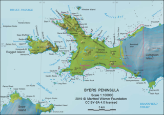
L.L. Ivanov. Antarctia: Byers
Peninsula. Scale 1:100000 topographic map. Manfred Wörner Foundation, 2019. Revised and updated version of the relevant fragment of the author’s 2010 map of Livingston Island and Greenwich, Robert, Snow and Smith
311:– You must give appropriate credit, provide a link to the license, and indicate if changes were made. You may do so in any reasonable manner, but not in any way that suggests the licensor endorses you or your use.
217:
402:
211:
755:
669:
549:
505:
414:
904:
859:
814:
747:
709:
665:
627:
501:
410:
406:
398:
751:
589:
545:
394:
1863:
552:"}},"text\/plain":{"en":{"P275":"Creative Commons Attribution-ShareAlike 4.0 International"}}}}": -->
417:"}},"text\/plain":{"en":{"P2699":"http:\/\/commons.wikimedia.org\/wiki\/User:Apcbg"}}}}": -->
65:
61:
57:
53:
47:
110:
78:
799:
695:
575:
531:
227:
1496:
1599:
1874:
This file contains additional information, probably added from the digital camera or scanner used to create or digitize it.
318:
194:
918:
873:
828:
765:
719:
679:
637:
515:
479:
464:
451:
1229:
1224:
1199:
1194:
1169:
1164:
1139:
1134:
1109:
1104:
1079:
1074:
1049:
1044:
1019:
1014:
672:"}},"text\/plain":{"en":{"P7482":"original creation by uploader"}}}}": -->
792:
599:
559:
424:
383:
1516:
1526:
280:
1877:
If the file has been modified from its original state, some details may not fully reflect the modified file.
471:
821:"}},"text\/plain":{"en":{"P3575":"1,286,469 byte"}}}}": -->
317:– If you remix, transform, or build upon the material, you must distribute your contributions under the
346:
Published by the
Manfred Wörner Foundation, and hereby released by the Foundation’s President and CEO
911:"}},"text\/plain":{"en":{"P2049":"1,848 pixel"}}}}": -->
866:"}},"text\/plain":{"en":{"P2048":"1,298 pixel"}}}}": -->
508:"}},"text\/plain":{"en":{"P6216":"copyrighted"}}}}": -->
1257:
The following pages on the
English Knowledge use this file (pages on other projects are not listed):
350:(Lyubomir Ivanov) for publication under the Creative Commons Attribution ShareAlike 4.0 license.
118:
989:
984:
758:"}},"text\/plain":{"en":{"P459":"SHA-1"}}}}": -->
69:
42:
486:
277:
8:
1629:
233:
1649:
1461:
105:
373:
252:
I, the copyright holder of this work, hereby publish it under the following license:
1486:
1396:
1376:
1341:
1286:
1566:
1551:
1521:
1471:
1316:
1581:
1561:
1536:
1456:
1451:
1431:
1421:
1411:
1306:
1296:
1531:
1674:
1571:
1556:
1386:
1381:
1371:
1366:
1336:
1311:
1301:
1291:
1281:
1276:
1261:
928:
883:
838:
775:
729:
689:
647:
609:
569:
525:
434:
1541:
1506:
1501:
1361:
1356:
1346:
1271:
1266:
347:
183:
1546:
1511:
1491:
1481:
1476:
1466:
1446:
1441:
1436:
1426:
1416:
1406:
1401:
1391:
1326:
1321:
1240:
1210:
1180:
1150:
1120:
1090:
1060:
1030:
1000:
1576:
1351:
1331:
957:
Click on a date/time to view the file as it appeared at that time.
367:
Topographic map of Byers
Peninsula, Livingston Island in Antarctica
1664:
219:
1749:
1854:
1639:
1839:
1834:
1814:
1764:
1659:
1844:
1744:
1704:
1654:
1619:
1609:
1849:
1804:
1784:
1779:
1759:
1754:
1714:
1689:
1644:
1614:
212:
62° 38′ 00″ S, 61° 05′ 00″ W
1829:
1819:
1809:
1719:
1699:
1684:
1679:
576:
Creative
Commons Attribution-ShareAlike 4.0 International
550:
Creative
Commons Attribution-ShareAlike 4.0 International
163:
93:
1824:
1799:
1774:
1669:
1794:
1789:
1769:
1739:
1734:
1729:
1724:
1709:
1694:
1634:
83:(1,848 × 1,298 pixels, file size: 1.23 MB, MIME type:
1255:
1590:
955:
117:
Commons is a freely licensed media file repository.
415:http:\/\/commons.wikimedia.org\/wiki\/User:Apcbg
328:https://creativecommons.org/licenses/by-sa/4.0
98:
334:Creative Commons Attribution-Share Alike 4.0
258:
159:
140:
189:
179:
169:
14:
908:
863:
818:
294:– to copy, distribute and transmit the work
1592:The following other wikis use this file:
281:Attribution-Share Alike 4.0 International
781:17215c97b412a9b8a7ce120a08ad4aab2312d2ad
1630:Rugged Island (Südliche Shetlandinseln)
487:http://commons.wikimedia.org/User:Apcbg
1497:Rugged Island (South Shetland Islands)
226:View this and other nearby images on:
129:
202:
1650:Long Rock (Südliche Shetlandinseln)
1247:User created page with UploadWizard
948:
269:
264:
195:File:Livingston-Island-Map-2010.jpg
13:
1872:
372:
366:
255:
251:
147:
130:
76:
1906:
1879:
1517:South Beaches (Livingston Island)
371:
1256:
638:coordinates of the point of view
628:coordinates of the point of view
357:
305:Under the following conditions:
276:This file is licensed under the
268:
263:
257:
232:
218:
97:
31:
21:
1527:Start Point (Livingston Island)
354:
148:
1675:Start Point (Livingston-Insel)
1587:
952:
353:
26:
1:
696:original creation by uploader
670:original creation by uploader
653:62°37'59.999"S, 61°4'59.999"W
193:Fragment of the Commons file
36:
1252:
379:Items portrayed in this file
245:
143:ASPA-126-Byers-Peninsula.png
7:
1869:
1606:Usage on ceb.wikipedia.org
10:
1911:
1626:Usage on de.wikipedia.org
1596:Usage on bg.wikipedia.org
319:same or compatible license
137:
132:
949:
173:
16:
356:
285:
104:This is a file from the
41:
1246:
1216:
1186:
1156:
1126:
1096:
1066:
1036:
1006:
985:12:14, 13 February 2019
238:-62.633333; -61.083333
162:
108:. Information from its
1225:10:06, 1 February 2019
1195:11:04, 1 February 2019
1165:21:06, 1 February 2019
1135:09:25, 3 February 2019
1105:08:07, 4 February 2019
1075:07:00, 5 February 2019
1045:15:24, 5 February 2019
1015:11:37, 6 February 2019
111:description page there
46:Size of this preview:
1883:Horizontal resolution
1665:New Plymouth (Bucht)
793:determination method
752:determination method
70:1,848 × 1,298 pixels
1891:Vertical resolution
300:– to adapt the work
52:Other resolutions:
465:Wikimedia username
452:author name string
407:Wikimedia username
399:author name string
66:1,280 × 899 pixels
62:1,024 × 719 pixels
1898:
1897:
1864:more global usage
1750:President Beaches
1588:Global file usage
1462:President Beaches
1250:
910:
865:
820:
560:copyright license
546:copyright license
365:
243:
242:
200:
199:
126:
125:
106:Wikimedia Commons
32:Global file usage
1902:
1880:
1855:San Stefano Peak
1600:Пистирос (езеро)
1237:
1207:
1177:
1147:
1117:
1087:
1057:
1027:
997:
959:
937:
892:
847:
802:
797:
516:copyright status
502:copyright status
489:
484:
474:
469:
459:
456:
363:
341:
338:
335:
332:
329:
321:as the original.
278:Creative Commons
272:
271:
267:
266:
261:
260:
239:
236:
222:
221:
215:
214:
203:
175:
165:
152:
144:
138:
122:
101:
100:
94:
88:
86:
73:
58:640 × 450 pixels
54:320 × 225 pixels
48:800 × 562 pixels
1910:
1909:
1905:
1904:
1903:
1901:
1900:
1899:
1868:
1840:Battenberg Hill
1815:Baba Tonka Cove
1765:Robbery Beaches
1660:Byers-Halbinsel
1586:
1487:Robbery Beaches
1397:Limnopolar Lake
1377:Kardzhali Point
1342:Eridanus Stream
1287:Byers Peninsula
1258:
1251:
1243:
1235:
1213:
1205:
1183:
1175:
1153:
1145:
1123:
1115:
1093:
1085:
1063:
1055:
1033:
1025:
1003:
995:
951:
950:
947:
946:
945:
944:
943:
942:
941:
940:
938:
935:
925:
924:
923:
921:
902:
901:
900:
899:
898:
897:
896:
895:
893:
890:
880:
879:
878:
876:
857:
856:
855:
854:
853:
852:
851:
850:
848:
845:
835:
834:
833:
831:
812:
811:
810:
809:
808:
807:
806:
805:
804:
803:
798:
795:
786:
785:
784:
782:
772:
771:
770:
768:
745:
744:
743:
742:
741:
740:
739:
738:
736:
726:
725:
724:
722:
707:
706:
705:
704:
703:
702:
701:
700:
698:
686:
685:
684:
682:
663:
662:
661:
660:
659:
658:
657:
656:
654:
644:
643:
642:
640:
625:
624:
623:
622:
621:
620:
619:
618:
616:
615:1 February 2019
606:
605:
604:
602:
587:
586:
585:
584:
583:
582:
581:
580:
578:
566:
565:
564:
562:
543:
542:
541:
540:
539:
538:
537:
536:
534:
522:
521:
520:
518:
499:
498:
497:
496:
495:
494:
493:
492:
491:
490:
485:
482:
476:
475:
470:
467:
461:
460:
457:
454:
445:
444:
443:
441:
431:
430:
429:
427:
392:
391:
390:
389:
388:
386:
370:
369:
368:
344:
343:
342:
339:
336:
333:
330:
327:
326:
284:
273:
254:
253:
248:
237:
210:
209:
206:Camera location
201:
164:1 February 2019
155:
142:
135:
128:
127:
116:
115:
114:is shown below.
90:
84:
82:
75:
74:
51:
12:
11:
5:
1908:
1896:
1895:
1892:
1888:
1887:
1884:
1871:
1866:of this file.
1860:
1859:
1858:
1857:
1852:
1847:
1845:Dospey Heights
1842:
1837:
1832:
1827:
1822:
1817:
1812:
1807:
1802:
1797:
1792:
1787:
1782:
1777:
1772:
1767:
1762:
1757:
1752:
1747:
1745:Ray Promontory
1742:
1737:
1732:
1727:
1722:
1717:
1712:
1707:
1705:President Head
1702:
1697:
1692:
1687:
1682:
1677:
1672:
1667:
1662:
1657:
1655:Elephant Point
1652:
1647:
1642:
1637:
1632:
1624:
1623:
1622:
1617:
1612:
1604:
1603:
1602:
1589:
1585:
1584:
1579:
1574:
1569:
1567:Volturnus Lake
1564:
1559:
1554:
1552:Varadero Point
1549:
1544:
1539:
1534:
1529:
1524:
1522:Sparadok Point
1519:
1514:
1509:
1504:
1499:
1494:
1489:
1484:
1479:
1474:
1472:Ray Promontory
1469:
1464:
1459:
1454:
1449:
1444:
1439:
1434:
1429:
1424:
1419:
1414:
1409:
1404:
1399:
1394:
1389:
1384:
1379:
1374:
1369:
1364:
1359:
1354:
1349:
1344:
1339:
1334:
1329:
1324:
1319:
1317:Dospey Heights
1314:
1309:
1304:
1299:
1294:
1289:
1284:
1279:
1274:
1269:
1264:
1254:
1249:
1248:
1245:
1241:
1238:
1234:1,848 × 1,298
1232:
1227:
1222:
1219:
1218:
1215:
1211:
1208:
1204:1,848 × 1,298
1202:
1197:
1192:
1189:
1188:
1185:
1181:
1178:
1174:1,848 × 1,298
1172:
1167:
1162:
1159:
1158:
1155:
1151:
1148:
1144:1,848 × 1,298
1142:
1137:
1132:
1129:
1128:
1125:
1121:
1118:
1114:1,848 × 1,298
1112:
1107:
1102:
1099:
1098:
1095:
1091:
1088:
1084:1,848 × 1,298
1082:
1077:
1072:
1069:
1068:
1065:
1061:
1058:
1054:1,848 × 1,298
1052:
1047:
1042:
1039:
1038:
1035:
1031:
1028:
1024:1,848 × 1,298
1022:
1017:
1012:
1009:
1008:
1005:
1001:
998:
994:1,848 × 1,298
992:
987:
982:
978:
977:
974:
971:
968:
965:
962:
954:
939:
933:
931:
930:
929:
927:
926:
922:
917:
915:
914:
913:
912:
906:
894:
888:
886:
885:
884:
882:
881:
877:
872:
870:
869:
868:
867:
861:
849:
843:
841:
840:
839:
837:
836:
832:
827:
825:
824:
823:
822:
816:
791:
790:
789:
788:
787:
783:
780:
778:
777:
776:
774:
773:
769:
764:
762:
761:
760:
759:
757:
753:
749:
737:
734:
732:
731:
730:
728:
727:
723:
718:
716:
715:
714:
713:
711:
699:
694:
692:
691:
690:
688:
687:
683:
680:source of file
678:
676:
675:
674:
673:
671:
667:
666:source of file
655:
652:
650:
649:
648:
646:
645:
641:
636:
634:
633:
632:
631:
629:
617:
614:
612:
611:
610:
608:
607:
603:
598:
596:
595:
594:
593:
591:
579:
574:
572:
571:
570:
568:
567:
563:
558:
556:
555:
554:
553:
551:
547:
535:
530:
528:
527:
526:
524:
523:
519:
514:
512:
511:
510:
509:
507:
503:
478:
477:
463:
462:
450:
449:
448:
447:
446:
442:
439:
437:
436:
435:
433:
432:
428:
423:
421:
420:
419:
418:
416:
412:
408:
404:
400:
396:
387:
382:
380:
377:
376:
375:
374:
362:
361:
358:
355:
325:
324:
323:
322:
312:
303:
302:
301:
295:
288:You are free:
275:
274:
256:
250:
249:
247:
244:
241:
240:
230:
224:
207:
198:
197:
191:
190:Other versions
187:
186:
181:
177:
176:
171:
167:
166:
161:
157:
156:
145:
136:
134:
131:
124:
123:
102:
92:
91:
45:
40:
39:
34:
29:
24:
19:
9:
6:
4:
3:
2:
1907:
1893:
1890:
1889:
1885:
1882:
1881:
1878:
1875:
1867:
1865:
1856:
1853:
1851:
1850:Bakshev Ridge
1848:
1846:
1843:
1841:
1838:
1836:
1833:
1831:
1828:
1826:
1823:
1821:
1818:
1816:
1813:
1811:
1808:
1806:
1805:Villard Point
1803:
1801:
1798:
1796:
1793:
1791:
1788:
1786:
1785:Point Smellie
1783:
1781:
1780:Kap Sheffield
1778:
1776:
1773:
1771:
1768:
1766:
1763:
1761:
1760:Window Island
1758:
1756:
1755:Richards Cove
1753:
1751:
1748:
1746:
1743:
1741:
1738:
1736:
1733:
1731:
1728:
1726:
1723:
1721:
1718:
1716:
1715:Hersilia Cove
1713:
1711:
1708:
1706:
1703:
1701:
1698:
1696:
1693:
1691:
1690:Clark-Nunatak
1688:
1686:
1683:
1681:
1678:
1676:
1673:
1671:
1668:
1666:
1663:
1661:
1658:
1656:
1653:
1651:
1648:
1646:
1645:Morton Strait
1643:
1641:
1638:
1636:
1633:
1631:
1628:
1627:
1625:
1621:
1620:Lloyds Island
1618:
1616:
1613:
1611:
1610:Byers (punta)
1608:
1607:
1605:
1601:
1598:
1597:
1595:
1594:
1593:
1583:
1582:Window Island
1580:
1578:
1575:
1573:
1570:
1568:
1565:
1563:
1562:Villard Point
1560:
1558:
1555:
1553:
1550:
1548:
1545:
1543:
1540:
1538:
1537:Tsamblak Hill
1535:
1533:
1530:
1528:
1525:
1523:
1520:
1518:
1515:
1513:
1510:
1508:
1505:
1503:
1500:
1498:
1495:
1493:
1490:
1488:
1485:
1483:
1480:
1478:
1475:
1473:
1470:
1468:
1465:
1463:
1460:
1458:
1457:Point Smellie
1455:
1453:
1452:Pistiros Lake
1450:
1448:
1445:
1443:
1440:
1438:
1435:
1433:
1432:Nikopol Point
1430:
1428:
1425:
1423:
1422:Nedelya Point
1420:
1418:
1415:
1413:
1412:Montemno Lake
1410:
1408:
1405:
1403:
1400:
1398:
1395:
1393:
1390:
1388:
1385:
1383:
1380:
1378:
1375:
1373:
1370:
1368:
1365:
1363:
1360:
1358:
1355:
1353:
1350:
1348:
1345:
1343:
1340:
1338:
1335:
1333:
1330:
1328:
1325:
1323:
1320:
1318:
1315:
1313:
1310:
1308:
1307:Diomedes Lake
1305:
1303:
1300:
1298:
1297:Clark Nunatak
1295:
1293:
1290:
1288:
1285:
1283:
1280:
1278:
1275:
1273:
1270:
1268:
1265:
1263:
1260:
1259:
1244:
1239:
1233:
1231:
1228:
1226:
1223:
1221:
1220:
1214:
1209:
1203:
1201:
1198:
1196:
1193:
1191:
1190:
1184:
1179:
1173:
1171:
1168:
1166:
1163:
1161:
1160:
1154:
1149:
1143:
1141:
1138:
1136:
1133:
1131:
1130:
1124:
1119:
1113:
1111:
1108:
1106:
1103:
1101:
1100:
1094:
1089:
1083:
1081:
1078:
1076:
1073:
1071:
1070:
1064:
1059:
1053:
1051:
1048:
1046:
1043:
1041:
1040:
1034:
1029:
1023:
1021:
1018:
1016:
1013:
1011:
1010:
1004:
999:
993:
991:
988:
986:
983:
980:
979:
975:
972:
969:
966:
963:
961:
960:
958:
932:
920:
916:
887:
875:
871:
842:
830:
826:
801:
794:
779:
767:
763:
733:
721:
717:
697:
693:
681:
677:
651:
639:
635:
613:
601:
597:
577:
573:
561:
557:
533:
529:
517:
513:
488:
481:
473:
466:
453:
438:
426:
422:
385:
381:
378:
359:
352:
351:
349:
331:CC BY-SA 4.0
320:
316:
313:
310:
307:
306:
304:
299:
296:
293:
290:
289:
287:
286:
282:
279:
262:
235:
231:
229:
228:OpenStreetMap
225:
223:
213:
208:
205:
204:
196:
192:
188:
185:
182:
178:
172:
168:
158:
151:
146:
139:
120:
113:
112:
107:
103:
96:
95:
89:
80:
79:Original file
71:
67:
63:
59:
55:
49:
44:
38:
35:
33:
30:
28:
25:
23:
20:
18:
15:
1876:
1873:
1861:
1830:Voyteh Point
1820:Kukuzel Cove
1810:Amadok Point
1720:Laager Point
1700:Devils Point
1685:Chester Cone
1680:Benson Point
1615:Ivanov Beach
1591:
1572:Voyteh Point
1557:Vardim Rocks
1387:Laager Point
1382:Kianida Reef
1372:Juturna Lake
1367:Ivanov Beach
1337:Enrique Hill
1312:Dometa Point
1302:Devils Point
1292:Chester Cone
1282:Bilyar Point
1277:Bedek Stream
1262:Acheron Lake
956:
953:File history
345:
314:
308:
297:
291:
149:
119:You can help
109:
77:
22:File history
1825:Aglen Point
1800:Vietor Rock
1775:Sealer Hill
1670:Essex Point
1640:Kap Timblón
1542:Urvich Wall
1507:Sevar Point
1502:Sealer Hill
1362:Isbul Point
1357:Fontus Lake
1347:Essex Point
1272:Basalt Lake
1267:Aglen Point
532:copyrighted
506:copyrighted
315:share alike
309:attribution
141:Description
1835:Sàbat Hill
1795:Usnea Plug
1790:Start Hill
1770:Rowe Point
1740:Penca Hill
1735:Ocoa Point
1730:Negro Hill
1725:Midge Lake
1710:Hell Gates
1695:Lair Point
1547:Usnea Plug
1532:Sàbat Hill
1512:Siren Lake
1492:Rowe Point
1482:Ritli Hill
1477:Rish Point
1467:Rame Bluff
1447:Penca Hill
1442:Oread Lake
1437:Ocoa Point
1427:Negro Hill
1417:Naiad Lake
1407:Mneme Lake
1402:Midge Lake
1392:Lair Point
1327:Dryad Lake
1322:Drong Hill
1253:File usage
970:Dimensions
844:1,286,469
720:media type
710:media type
440:some value
27:File usage
1635:Aim Rocks
1577:Wasp Hill
1352:Feya Tarn
1332:Dulo Hill
1236:(1.21 MB)
1206:(1.17 MB)
1176:(1.21 MB)
1146:(1.22 MB)
1116:(1.22 MB)
1086:(1.22 MB)
1056:(1.22 MB)
1026:(1.23 MB)
996:(1.23 MB)
967:Thumbnail
964:Date/Time
829:data size
815:data size
735:image/png
600:inception
590:inception
246:Licensing
150:English:
85:image/png
1894:37.8 dpc
1886:37.8 dpc
1870:Metadata
766:checksum
748:checksum
360:Captions
298:to remix
292:to share
283:license.
174:Own work
154:Islands.
37:Metadata
981:current
976:Comment
425:creator
395:creator
384:depicts
364:English
133:Summary
81:
934:1,848
889:1,298
874:height
860:height
216:
180:Author
170:Source
1862:View
1242:Apcbg
1217:minor
1212:Apcbg
1187:minor
1182:Apcbg
1157:Minor
1152:Apcbg
1127:minor
1122:Apcbg
1097:Minor
1092:Apcbg
1067:Minor
1062:Apcbg
1037:Minor
1032:Apcbg
1007:Minor
1002:Apcbg
936:pixel
919:width
909:pixel
905:width
891:pixel
864:pixel
800:SHA-1
756:SHA-1
472:Apcbg
458:Apcbg
403:Apcbg
348:Apcbg
184:Apcbg
973:User
846:byte
819:byte
340:true
337:true
160:Date
17:File
480:URL
411:URL
796::
483::
468::
455::
68:|
64:|
60:|
56:|
50:.
121:.
87:)
72:.
