329:
153:
160:
127:
120:
31:
75:
399:
370:
394:
152:
119:
363:
389:
61:
68:
356:
283:
266:
336:
262:
8:
328:
344:
56:
250:
217:
278:
340:
210:
383:
90:
77:
229:
193:
254:
202:
197:
189:
30:
269:. This mountain has an elevation of 941 metres above sea level.
46:
303:
258:
381:
35:View of the Creu de Santos (or Xàquera) summit
364:
371:
357:
382:
159:
126:
400:Province of Tarragona geography stubs
323:
261:. The Serra de Cardó is part of the
306:. Institut Cartogràfic de Catalunya
13:
14:
411:
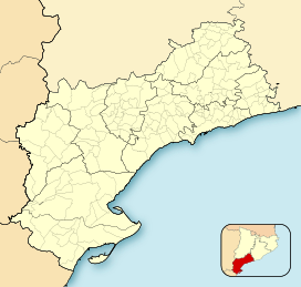
142:Show map of Province of Tarragona
327:
158:
151:
125:
118:
29:
395:Emblematic summits of Catalonia
249:is the highest mountain of the
304:"Mapa Topogràfic de Catalunya"
296:
1:
289:
343:. You can help Knowledge by
7:
272:
10:
416:
322:
172:Creu de Santos (Catalonia)
51:941 m (3,087 ft)
284:Catalan Pre-Coastal Range
267:Catalan Pre-Coastal Range
228:
223:
209:
185:
111:
106:
67:
55:
45:
40:
28:
23:
18:
91:40.9405222°N 0.5860472°E
390:Mountains of Catalonia
339:location article is a
62:Mountains in Catalonia
337:Province of Tarragona
175:Show map of Catalonia
96:40.9405222; 0.5860472
87: /
41:Highest point
352:
351:
240:
239:
407:
373:
366:
359:
331:
324:
317:
315:
313:
311:
300:
232:
213:
176:
162:
161:
155:
143:
129:
128:
122:
102:
101:
99:
98:
97:
92:
88:
85:
84:
83:
80:
33:
16:
15:
415:
414:
410:
409:
408:
406:
405:
404:
380:
379:
378:
377:
321:
320:
309:
307:
302:
301:
297:
292:
275:
263:Massís de Cardó
230:
211:
201:
181:
180:
179:
178:
177:
174:
173:
170:
169:
168:
167:
163:
146:
145:
144:
141:
140:
137:
136:
135:
134:
130:
95:
93:
89:
86:
81:
78:
76:
74:
73:
36:
12:
11:
5:
413:
403:
402:
397:
392:
376:
375:
368:
361:
353:
350:
349:
332:
319:
318:
294:
293:
291:
288:
287:
286:
281:
274:
271:
251:Serra de Cardó
243:Creu de Santos
238:
237:
234:
226:
225:
221:
220:
218:Serra de Cardó
215:
207:
206:
187:
183:
182:
171:
166:Creu de Santos
165:
164:
157:
156:
150:
149:
148:
147:
138:
133:Creu de Santos
132:
131:
124:
123:
117:
116:
115:
114:
113:
112:
109:
108:
104:
103:
71:
65:
64:
59:
53:
52:
49:
43:
42:
38:
37:
34:
26:
25:
21:
20:
19:Creu de Santos
9:
6:
4:
3:
2:
412:
401:
398:
396:
393:
391:
388:
387:
385:
374:
369:
367:
362:
360:
355:
354:
348:
346:
342:
338:
333:
330:
326:
325:
305:
299:
295:
285:
282:
280:
277:
276:
270:
268:
264:
260:
256:
252:
248:
244:
235:
233:
231:Easiest route
227:
222:
219:
216:
214:
208:
204:
199:
195:
191:
188:
184:
154:
121:
110:
105:
100:
79:40°56′25.88″N
72:
70:
66:
63:
60:
58:
54:
50:
48:
44:
39:
32:
27:
22:
17:
345:expanding it
334:
308:. Retrieved
298:
279:Cardó Massif
246:
242:
241:
212:Parent range
94: /
82:0°35′9.77″E
69:Coordinates
384:Categories
290:References
194:Benifallet
255:Catalonia
203:Catalonia
107:Geography
47:Elevation
273:See also
224:Climbing
198:Rasquera
186:Location
139:Location
310:May 22,
253:range,
247:Xàquera
205:, Spain
190:Tivenys
57:Listing
24:Xàquera
196:, and
335:This
259:Spain
341:stub
312:2010
236:Walk
245:or
386::
265:,
257:,
192:,
372:e
365:t
358:v
347:.
316:.
314:.
200:,
Text is available under the Creative Commons Attribution-ShareAlike License. Additional terms may apply.
↑


