172:
179:
146:
113:
139:
106:
29:
294:(4,135 m (13,566 ft)), located in the immediate vicinity (4 km (2.5 mi) away), is the second highest mountain in Turkey. In 1984, the area was closed to civilians. It was not until 2002 that a team of mountaineers was authorized to climb again the Cilo mountains.
61:
171:
409:
399:
404:
384:
359:
138:
105:
414:
54:
316:
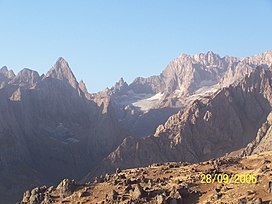
270:. It is 4,116 m (13,504 ft) high and lies in the Hakkâri Dağları chain, located in the eastern
424:
419:
8:
370:
307:
279:
213:
231:
290:
Cilo Dağı is part of Cilo mountain range, which is 30 km (19 mi) long. The
259:
291:
271:
251:
239:
235:
350:
Brockhaus, Enzyklopädie in 30 Bänden, Vol. 28. Mannheim 2006, p. 117, s.v. Türkei.
224:
393:
341:
The New
Encyclopaedia Britannica: Macropaedia. University of Michigan p. 920
303:
76:
63:
275:
208:
321:
28:
267:
217:
44:
311:
391:
392:
410:Mountains of the Armenian Highlands
266:) is the third highest mountain in
255:
13:
14:
436:
378:
194:Show map of West and Central Asia
191:Cilo Dağı (West and Central Asia)
178:
145:
112:
177:
170:
144:
137:
111:
104:
27:
405:Important Bird Areas of Turkey
364:
353:
344:
335:
285:
1:
400:Landforms of Hakkâri Province
329:
49:4,116 m (13,504 ft)
371:Hürriyet, 28. September 2002
7:
317:List of mountains in Turkey
297:
10:
441:
360:www.tuerkei-kultur-info.de
263:
223:
204:
97:
92:
53:
43:
38:
26:
21:
161:Show map of Middle East
158:Cilo Dağı (Middle East)
276:district of Yüksekova
415:Mountains of Turkey
385:Sketch of the range
73: /
128:Show map of Turkey
39:Highest point
16:Mountain in Turkey
245:
244:
77:37.500°N 43.967°E
432:
425:Zagros Mountains
420:Taurus Mountains
373:
368:
362:
357:
351:
348:
342:
339:
280:Hakkâri Province
265:
257:
240:Zagros Mountains
227:
214:Hakkâri Province
195:
181:
180:
174:
162:
148:
147:
141:
129:
115:
114:
108:
88:
87:
85:
84:
83:
78:
74:
71:
70:
69:
66:
31:
19:
18:
440:
439:
435:
434:
433:
431:
430:
429:
390:
389:
381:
376:
369:
365:
358:
354:
349:
345:
340:
336:
332:
300:
288:
225:
212:
200:
199:
198:
197:
196:
193:
192:
189:
188:
187:
186:
182:
165:
164:
163:
160:
159:
156:
155:
154:
153:
149:
132:
131:
130:
127:
126:
123:
122:
121:
120:
116:
81:
79:
75:
72:
67:
64:
62:
60:
59:
34:
17:
12:
11:
5:
438:
428:
427:
422:
417:
412:
407:
402:
388:
387:
380:
379:External links
377:
375:
374:
363:
352:
343:
333:
331:
328:
327:
326:
325:
324:
314:
299:
296:
287:
284:
243:
242:
229:
221:
220:
206:
202:
201:
190:
184:
183:
176:
175:
169:
168:
167:
166:
157:
151:
150:
143:
142:
136:
135:
134:
133:
124:
118:
117:
110:
109:
103:
102:
101:
100:
99:
98:
95:
94:
90:
89:
82:37.500; 43.967
57:
51:
50:
47:
41:
40:
36:
35:
32:
24:
23:
15:
9:
6:
4:
3:
2:
437:
426:
423:
421:
418:
416:
413:
411:
408:
406:
403:
401:
398:
397:
395:
386:
383:
382:
372:
367:
361:
356:
347:
338:
334:
323:
320:
319:
318:
315:
313:
309:
305:
302:
301:
295:
293:
283:
281:
277:
273:
269:
261:
253:
249:
241:
237:
233:
230:
228:
222:
219:
215:
210:
207:
203:
173:
140:
107:
96:
91:
86:
58:
56:
52:
48:
46:
42:
37:
30:
25:
20:
366:
355:
346:
337:
289:
247:
246:
226:Parent range
286:Description
256:Çiyayê Cîlo
80: /
55:Coordinates
394:Categories
330:References
322:Mount Judi
274:, in the
248:Cilo Dağı
209:Yüksekova
185:Cilo Dağı
152:Cilo Dağı
119:Cilo Dağı
93:Geography
45:Elevation
33:Cilo Dağı
22:Cilo Dağı
298:See also
292:Uludoruk
264:Ջողա լեռ
260:Armenian
232:Armenian
205:Location
278:of the
252:Kurdish
68:43°58′E
65:37°30′N
272:Taurus
268:Turkey
236:Taurus
218:Turkey
125:Turkey
312:Noah
310:or
308:Nuh
306:of
304:Ark
282:.
396::
262::
258:;
254::
238:/
234:/
216:,
250:(
211:,
Text is available under the Creative Commons Attribution-ShareAlike License. Additional terms may apply.


