29:
458:
353:
253:
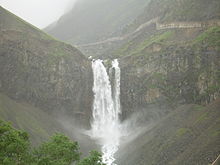
Access to the waterfall is available year-round via a sheltered VIP path up the mountain (visible in photos to the right of the falls). The path is fully enclosed but has windows spaced along the steps. The enclosure protects the path from blockage by snowfall and ice, and is closed during summer.
217:) basin. Tianchi lake is usually frozen over until late June or July. Flow over the waterfall is reduced in winter months but it never completely freezes over since the lake drains from depth below the ice and the water is geothermally heated beneath year-round. The current
65:
228:. The Songhua flows northward into the Amur, forming China's border with Russia, and eventually into the Sea of Okhotsk facing Sakhalin Island and the northern Pacific.
224:
Julong Hot
Springs below the falls create pools full of colorful algae that thrive in the geothermal water upwelling. This contributes headwater flow to the young
241:
Koreans and Jilin residents traditionally consider the waters of the lake to be sacred. Many Korean-speaking natives bring a bottle to capture some
385:
499:
357:
378:
528:
138:
523:
492:
371:
218:
58:
324:
518:
408:
485:
168:
295:
271:
188:
428:
418:
473:
192:
8:
439:
413:
164:
200:
423:
160:
469:
512:
242:
225:
126:
81:
67:
196:
187:
With a drop of 68 m (223 ft), the
Changbai Waterfall is in the
176:
363:
156:
195:. It is most dramatic during the summer snow-melt season from the
43:
28:
352:
221:
passes nearby, through the center of the alpine Lake
Tianchi.
208:
146:
457:
325:"Changbai Waterfall - The Main Waterfall of Changbai Mountain"
465:
172:
51:
47:
319:
317:
315:
312:
510:
272:"Chinese Lakes-Virtual Science Museum of China"
493:
379:
191:as the largest waterfall originating from a
155:) is a 68 m (223 ft)-tall alpine
500:
486:
386:
372:
296:"Mount Changbai Sets Two Guinness Records"
27:
393:
511:
367:
452:
163:, located to the north slope of the
13:
14:
540:
345:
456:
351:
236:
288:
264:
213:
151:
142:
1:
257:
472:. You can help Knowledge by
182:
167:, the tallest summit of the
7:
10:
545:
451:
248:
231:
437:
399:
204:
121:
113:
105:
57:
39:
35:
26:
21:
16:Waterfall in Jilin, China
219:China–North Korea border
82:42.035178°N 128.052184°E
169:Changbai Mountain Range
109:68 m (223 ft)
468:location article is a
189:Guinness World Records
529:Jilin geography stubs
429:Pearl Shoal Waterfall
419:Huangguoshu Waterfall
409:Ban Gioc–Detian Falls
87:42.035178; 128.052184
360:at Wikimedia Commons
193:volcanic crater lake
524:Waterfalls of China
394:Waterfalls of China
329:World of Waterfalls
77: /
519:Landforms of Jilin
440:Geography of China
404:Changbai Waterfall
358:Changbai Waterfall
135:Changbai Waterfall
93:Changbai Waterfall
22:Changbai Waterfall
481:
480:
446:
445:
414:Diaoshuilou Falls
356:Media related to
165:Changbai Mountain
132:
131:
536:
502:
495:
488:
460:
453:
388:
381:
374:
365:
364:
355:
339:
338:
336:
335:
321:
310:
309:
307:
306:
292:
286:
285:
283:
282:
268:
215:
206:
153:
144:
125:Erdaobai River,
101:
100:
98:
97:
96:
94:
89:
88:
83:
78:
75:
74:
73:
70:
31:
19:
18:
544:
543:
539:
538:
537:
535:
534:
533:
509:
508:
507:
506:
449:
447:
442:
433:
424:Hukou Waterfall
395:
392:
348:
343:
342:
333:
331:
323:
322:
313:
304:
302:
294:
293:
289:
280:
278:
276:www.kepu.net.cn
270:
269:
265:
260:
251:
239:
234:
185:
161:Northeast China
114:Number of drops
92:
90:
86:
84:
80:
79:
76:
71:
68:
66:
64:
63:
17:
12:
11:
5:
542:
532:
531:
526:
521:
505:
504:
497:
490:
482:
479:
478:
461:
444:
443:
438:
435:
434:
432:
431:
426:
421:
416:
411:
406:
400:
397:
396:
391:
390:
383:
376:
368:
362:
361:
347:
346:External links
344:
341:
340:
311:
287:
262:
261:
259:
256:
250:
247:
238:
235:
233:
230:
184:
181:
130:
129:
123:
119:
118:
115:
111:
110:
107:
103:
102:
61:
55:
54:
41:
37:
36:
33:
32:
24:
23:
15:
9:
6:
4:
3:
2:
541:
530:
527:
525:
522:
520:
517:
516:
514:
503:
498:
496:
491:
489:
484:
483:
477:
475:
471:
467:
462:
459:
455:
454:
450:
441:
436:
430:
427:
425:
422:
420:
417:
415:
412:
410:
407:
405:
402:
401:
398:
389:
384:
382:
377:
375:
370:
369:
366:
359:
354:
350:
349:
330:
326:
320:
318:
316:
301:
297:
291:
277:
273:
267:
263:
255:
246:
244:
237:Folk religion
229:
227:
226:Songhua river
222:
220:
216:
210:
202:
198:
194:
190:
180:
178:
174:
170:
166:
162:
158:
154:
152:Chángbái Pùbù
148:
140:
136:
128:
127:Songhua River
124:
120:
116:
112:
108:
104:
99:
62:
60:
56:
53:
49:
45:
42:
38:
34:
30:
25:
20:
474:expanding it
463:
448:
403:
332:. Retrieved
328:
303:. Retrieved
300:en.people.cn
299:
290:
279:. Retrieved
275:
266:
252:
243:sacred water
240:
223:
212:
186:
150:
134:
133:
106:Total height
197:Heaven Lake
177:North Korea
122:Watercourse
85: /
72:128°03′08″E
59:Coordinates
513:Categories
334:2020-10-04
305:2020-10-04
281:2020-10-04
258:References
91: (
69:42°02′07″N
183:Geography
157:waterfall
171:between
40:Location
249:Tourism
232:Culture
214:Tiānchí
201:Chinese
139:Chinese
44:Yanbian
211::
209:pinyin
203::
149::
147:pinyin
141::
466:Jilin
464:This
173:China
52:China
48:Jilin
470:stub
175:and
143:长白瀑布
159:in
515::
327:.
314:^
298:.
274:.
245:.
207:;
205:天池
179:.
145:;
50:,
46:,
501:e
494:t
487:v
476:.
387:e
380:t
373:v
337:.
308:.
284:.
199:(
137:(
117:2
95:)
Text is available under the Creative Commons Attribution-ShareAlike License. Additional terms may apply.
