220:
39:
305:(influenced by the presence of mangroves). There are two other types of soil found in the reserve: lomic sandy soil found in the beach areas, and the loamy clay silt found throughout the parts of the forest that are not submerged. All types of soil in the reserve are of high acidity and salinity.
276:
The average annual precipitation in the reserve is 1,312 mm of rain per year, and its average temperatures are of 26.1C. The driest month in the forest is
February and the most humid season is analogous to the wet season between the months of May to September.
378:). A large number of migratory bird species, both breeding and non-breeding populations, can also be found in the reserve. The forest and surrounding maritime areas are also home to the
472:
360:
Mangrove forests such as this are ideal for numerous species of fish, birds and crustaceans. The forest is also home to a large number of bird species such as the Bahama pintail (
259:(DRNA) then designated the remaining portion as an irreplaceable forest reserve based on its biological, cultural and historical importance and legacy through executive order
1069:
256:
106:
263:. After Roosevelt Roads was closed down there have been pushes to integrate sections of the former naval station and of the Punta Figueras area into the state forest.
515:
352:
can be found in the maritime areas of the reserve and it is a source of food and refuge for numerous animal species. Vegetation is rarer in the salt marshes.
1084:
1046:
605:
189:
forests which are habitat to a large number of bird species. Although named Ceiba State Forest, the forest is not home to the large ceiba tree (
595:
219:
1148:
508:
1153:
646:
1128:
532:
501:
248:
816:
881:
577:
524:
199:
it is located in. In addition to the mangrove forests, the reserve also includes coastal zones that comprise sandy beaches and
137:
541:
1123:
631:
1000:
871:
674:
641:
396:
651:
636:
473:"Grupo multisectorial desarrolla plan de acción para evitar perder terrenos traspasados en Ceiba por los federales"
1021:
559:
952:
891:
811:
798:
727:
1138:
942:
886:
289:. Most of the year the soil in the reserve is found under sea water, and most of the soils are classified as
252:
224:
911:
1133:
374:
1051:
742:
368:
235:
proclaimed and designated mora than 800 acres of coastal mangrove forest between the municipalities of
142:
841:
757:
692:
567:
244:
96:
752:
806:
737:
623:
687:
767:
906:
747:
717:
856:
846:
712:
707:
722:
362:
332:
762:
318:
The forest is home to all four types of mangrove forest found in Puerto Rico: red mangrove (
732:
682:
391:
240:
236:
208:
182:
61:
8:
697:
379:
326:
1026:
416:
231:
The forest's ecological value has been recognized since 1918, when Puerto Rico governor
1143:
851:
613:
338:
204:
196:
178:
57:
38:
916:
788:
772:
320:
821:
549:
876:
154:
25:
984:
921:
896:
826:
493:
349:
191:
170:
1005:
968:
947:
836:
344:
448:
1117:
1099:
1086:
901:
861:
590:
298:
382:, the population of which is still classified as endangered in Puerto Rico.
866:
831:
585:
302:
232:
665:
174:
937:
200:
92:
294:
286:
186:
293:
or wetland soil. These types of soil are characterized for being
247:
transferred a large portion of this zone and granted it to the
118:
1070:
Puerto Rico
Department of Natural and Environmental Resources
290:
257:
Puerto Rico
Department of Natural and Environmental Resources
107:
Puerto Rico
Department of Natural and Environmental Resources
285:
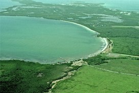
About 95% of the ground in the forest reserve is covered by
185:. The forest extends over 350 acres and is mostly made of
173:and nature reserve located in the eastern coast of
523:
372:) and the endangered yellow-shouldered blackbird (
1115:
223:A portion of the reserve was transferred to the
1047:Parque Nacional de las Cavernas del Río Camuy
1036:
509:
516:
502:
218:
1116:
195:), and it is actually named after the
497:
449:"Bosque estatal de Ceiba Puerto Rico"
336:) and buttonwood or button mangrove (
542:National Estuarine Research Reserves
443:
441:
439:
437:
435:
433:
1149:Protected areas established in 1918
366:), the West Indian whistling duck (
348:) is also very common in the area.
13:
1154:1918 establishments in Puerto Rico
43:Aerial view of Ceiba State Forest.
14:
1165:
1001:La Robleda Natural Protected Area
430:
397:List of Puerto Rico state forests
37:
578:National Wild and Scenic Rivers
1129:Protected areas of Puerto Rico
953:Palmas del Mar Tropical Forest
525:Protected areas of Puerto Rico
465:
409:
1:
1022:Mata de Plátano Field Station
943:Foreman Conservation Easement
887:Northeast Ecological Corridor
402:
253:Roosevelt Roads Naval Station
225:Roosevelt Roads Naval Station
912:San Juan Ecological Corridor
266:
7:
931:Conservation Easement Sites
385:
177:, in the municipalities of
161:), also referred to as the
16:State forest in Puerto Rico
10:
1170:
1052:Julio Enrique Monagas Park
308:
280:
271:
214:
143:Greater Antilles mangroves
1124:Puerto Rico state forests
1064:
1037:
1035:
1014:
993:
977:
961:
930:
797:
781:
673:
664:
624:National Wildlife Refuges
622:
604:
576:
558:
540:
531:
136:
131:
113:
102:
88:
83:
75:
67:
53:
48:
36:
21:
807:Aguas Buenas Cave System
355:
313:
167:Reserva Estatal de Ceiba
79:352 acres (362 cda)
994:Protected Natural Areas
882:Mona and Monito Islands
251:for the development of
245:Puerto Rican government
159:Bosque Estatal de Ceiba
30:Bosque Estatal de Ceiba
857:Humacao Nature Reserve
847:Cuevas Las Cabachuelas
228:
29:
333:Laguncularia racemosa
222:
1139:Fajardo, Puerto Rico
907:San Cristóbal Canyon
392:Aguirre State Forest
71:10 feet (3.0 m)
1096: /
380:West Indian manatee
369:Dendrocygna arborea
330:), white mangrove (
327:Avicennia germinans
324:), black mangrove (
163:Ceiba State Reserve
103:Governing body
1134:Ceiba, Puerto Rico
1038:Parques Nacionales
962:Conservation Zones
872:La Cordillera Reef
867:Inés María Mendoza
852:Hacienda Belvedere
375:Agelaius xanthomus
339:Conocarpus erectus
249:federal government
229:
203:found in both the
151:Ceiba State Forest
138:WWF Classification
22:Ceiba State Forest
1079:
1078:
1060:
1059:
1015:Research Reserves
917:Tortuguero Lagoon
789:Bosque del Pueblo
728:Los Tres Picachos
660:
659:
321:Rhizophora mangle
148:
147:
1161:
1111:
1110:
1108:
1107:
1106:
1101:
1097:
1094:
1093:
1092:
1089:
1040:
1027:Sierra de Jájome
877:Las Bocas Canyon
817:Caño Martín Peña
671:
670:
647:Laguna Cartagena
606:Wilderness Areas
560:National Forests
538:
537:
518:
511:
504:
495:
494:
488:
487:
485:
484:
469:
463:
462:
460:
459:
453:www.prfrogui.com
445:
428:
427:
425:
424:
413:
127:
124:
122:
120:
41:
32:
19:
18:
1169:
1168:
1164:
1163:
1162:
1160:
1159:
1158:
1114:
1113:
1104:
1102:
1100:18.32°N 65.63°W
1098:
1095:
1090:
1087:
1085:
1083:
1082:
1080:
1075:
1056:
1031:
1010:
989:
985:Isla Verde Reef
978:Marine Reserves
973:
957:
926:
922:Tourmaline Reef
897:Puerto Mosquito
892:Planadas-Yeyesa
842:Cueva del Indio
827:Cerro Las Tetas
812:Caja de Muertos
799:Nature Reserves
793:
777:
656:
618:
600:
572:
554:
527:
522:
492:
491:
482:
480:
471:
470:
466:
457:
455:
447:
446:
431:
422:
420:
415:
414:
410:
405:
388:
363:Anas bahamensis
358:
316:
311:
283:
274:
269:
255:. In 1979, the
243:. In 1941, the
217:
192:Ceiba pentandra
171:mangrove forest
117:
44:
24:
23:
17:
12:
11:
5:
1167:
1157:
1156:
1151:
1146:
1141:
1136:
1131:
1126:
1077:
1076:
1074:
1073:
1065:
1062:
1061:
1058:
1057:
1055:
1054:
1049:
1043:
1041:
1033:
1032:
1030:
1029:
1024:
1018:
1016:
1012:
1011:
1009:
1008:
1006:Sierra Pandura
1003:
997:
995:
991:
990:
988:
987:
981:
979:
975:
974:
972:
971:
969:Northern Karst
965:
963:
959:
958:
956:
955:
950:
948:Montes Oscuros
945:
940:
934:
932:
928:
927:
925:
924:
919:
914:
909:
904:
899:
894:
889:
884:
879:
874:
869:
864:
859:
854:
849:
844:
839:
837:Condado Lagoon
834:
829:
824:
822:Caño Tiburones
819:
814:
809:
803:
801:
795:
794:
792:
791:
785:
783:
779:
778:
776:
775:
770:
765:
760:
755:
750:
745:
740:
735:
730:
725:
720:
715:
710:
705:
700:
695:
690:
685:
679:
677:
668:
662:
661:
658:
657:
655:
654:
649:
644:
639:
634:
628:
626:
620:
619:
617:
616:
610:
608:
602:
601:
599:
598:
596:Río de la Mina
593:
588:
582:
580:
574:
573:
571:
570:
564:
562:
556:
555:
553:
552:
550:Bahía de Jobos
546:
544:
535:
529:
528:
521:
520:
513:
506:
498:
490:
489:
464:
429:
407:
406:
404:
401:
400:
399:
394:
387:
384:
357:
354:
345:Batis maritima
315:
312:
310:
307:
282:
279:
273:
270:
268:
265:
216:
213:
146:
145:
140:
134:
133:
129:
128:
115:
111:
110:
104:
100:
99:
90:
86:
85:
84:Administration
81:
80:
77:
73:
72:
69:
65:
64:
55:
51:
50:
46:
45:
42:
34:
33:
15:
9:
6:
4:
3:
2:
1166:
1155:
1152:
1150:
1147:
1145:
1142:
1140:
1137:
1135:
1132:
1130:
1127:
1125:
1122:
1121:
1119:
1112:
1109:
1105:18.32; -65.63
1072:
1071:
1067:
1066:
1063:
1053:
1050:
1048:
1045:
1044:
1042:
1039:
1034:
1028:
1025:
1023:
1020:
1019:
1017:
1013:
1007:
1004:
1002:
999:
998:
996:
992:
986:
983:
982:
980:
976:
970:
967:
966:
964:
960:
954:
951:
949:
946:
944:
941:
939:
936:
935:
933:
929:
923:
920:
918:
915:
913:
910:
908:
905:
903:
902:Punta Petrona
900:
898:
895:
893:
890:
888:
885:
883:
880:
878:
875:
873:
870:
868:
865:
863:
862:Joyuda Lagoon
860:
858:
855:
853:
850:
848:
845:
843:
840:
838:
835:
833:
830:
828:
825:
823:
820:
818:
815:
813:
810:
808:
805:
804:
802:
800:
796:
790:
787:
786:
784:
782:Other Forests
780:
774:
771:
769:
766:
764:
761:
759:
756:
754:
751:
749:
746:
744:
743:Nuevo Milenio
741:
739:
736:
734:
731:
729:
726:
724:
721:
719:
716:
714:
711:
709:
706:
704:
701:
699:
696:
694:
691:
689:
686:
684:
681:
680:
678:
676:
675:State Forests
672:
669:
667:
663:
653:
650:
648:
645:
643:
640:
638:
635:
633:
630:
629:
627:
625:
621:
615:
612:
611:
609:
607:
603:
597:
594:
592:
589:
587:
584:
583:
581:
579:
575:
569:
566:
565:
563:
561:
557:
551:
548:
547:
545:
543:
539:
536:
534:
530:
526:
519:
514:
512:
507:
505:
500:
499:
496:
478:
474:
468:
454:
450:
444:
442:
440:
438:
436:
434:
418:
412:
408:
398:
395:
393:
390:
389:
383:
381:
377:
376:
371:
370:
365:
364:
353:
351:
347:
346:
342:). Saltwort (
341:
340:
335:
334:
329:
328:
323:
322:
306:
304:
300:
296:
292:
288:
278:
264:
262:
258:
254:
250:
246:
242:
238:
234:
226:
221:
212:
210:
206:
202:
198:
194:
193:
188:
184:
180:
176:
172:
168:
164:
160:
156:
152:
144:
141:
139:
135:
130:
126:
116:
112:
108:
105:
101:
98:
94:
91:
87:
82:
78:
74:
70:
66:
63:
59:
56:
52:
47:
40:
35:
31:
27:
20:
1081:
1068:
832:Cibuco Swamp
758:San Patricio
702:
666:Commonwealth
481:. Retrieved
479:. 2015-11-07
476:
467:
456:. Retrieved
452:
421:. Retrieved
419:(in Spanish)
411:
373:
367:
361:
359:
343:
337:
331:
325:
319:
317:
295:argillaceous
284:
275:
260:
233:Arthur Yager
230:
197:municipality
190:
166:
162:
158:
150:
149:
97:Commonwealth
1103: /
738:Monte Choca
591:Río Mameyes
201:coral reefs
175:Puerto Rico
1118:Categories
938:El Rabanal
768:Toro Negro
693:Cambalache
586:Río Icacos
483:2021-10-09
458:2021-10-09
423:2021-10-09
403:References
261:OE-1996-57
211:sections.
165:(Spanish:
1144:Mangroves
753:Río Abajo
713:Guajataca
708:Cerrillos
632:Cabo Rojo
568:El Yunque
267:Geography
123:.gobierno
68:Elevation
49:Geography
723:Guilarte
688:Boquerón
642:Desecheo
386:See also
350:Seagrass
287:mangrove
227:in 1941.
187:mangrove
169:), is a
54:Location
1091:65°38′W
1088:18°19′N
748:Piñones
733:Maricao
718:Guánica
683:Aguirre
652:Vieques
637:Culebra
614:El Toro
533:Federal
417:"Ceiba"
309:Ecology
303:organic
281:Geology
272:Climate
241:Naguabo
237:Fajardo
215:History
209:Fajardo
183:Fajardo
155:Spanish
132:Ecology
114:Website
62:Fajardo
26:Spanish
698:Carite
299:saline
109:(DRNA)
93:Public
89:Status
763:Susúa
703:Ceiba
356:Fauna
314:Flora
291:marsh
205:Ceiba
179:Ceiba
121:.drna
58:Ceiba
773:Vega
477:DRNA
301:and
239:and
207:and
181:and
76:Area
60:and
125:.pr
119:www
1120::
475:.
451:.
432:^
297:,
157::
95:,
28::
517:e
510:t
503:v
486:.
461:.
426:.
153:(
Text is available under the Creative Commons Attribution-ShareAlike License. Additional terms may apply.
.jpg)