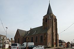
337:
48:
246:
325:
136:
64:
313:
522:
502:
71:
268:. Beerzel was a municipality until 1977, at which time it had an area of 7.83 square kilometres (3.02 sq mi) with 4,971 inhabitants in 1995. At 51.6 metres (169 ft), Antwerp's highest point—the
247:
95:
582:
364:
563:
280:
Pottery from the early Bronze age had been discovered in
Beerzel. The village was first mentioned as Barsale in 1151. Until the
336:
288:
was located at the top of the
Beerzelberg. Beerzel was an independent municipality until 1977 when it merged into Putte.
149:
592:
47:
161:
556:
469:
63:
324:
549:
173:
506:
446:
127:
224:
312:
8:
474:
441:
389:
415:
529:
257:
166:
537:
285:
587:
533:
240:
154:
576:
110:
97:
297:
261:
281:
219:
521:
253:
141:
17:
501:
265:
178:
365:"Bevolking per statistische sector - Sector 12029B"
574:
557:
564:
550:
132:
23:Village in the Flemish Region of Belgium
575:
470:"Hulde aan meesterknecht Jos Huysmans"
382:
359:
357:
239:
583:Populated places in Antwerp Province
516:
354:
193:7.81 km (3.02 sq mi)
13:
14:
604:
494:
291:
520:
500:
335:
323:
311:
300:(1941–2012), road bicycle racer.
134:
69:
62:
46:
70:
462:
434:
408:
272:—is located in Beerzel.
1:
347:
536:. You can help Knowledge by
447:Agentschap Onroerend Erfgoed
420:putter.natuurpuntdeputter.be
394:Agentschap Onroerend Erfgoed
7:
10:
609:
515:
304:
275:
15:
218:
214:790/km (2,100/sq mi)
210:
202:
197:
189:
184:
172:
160:
148:
126:
91:
57:
45:
38:
31:
26:Village in Flemish Region
342:Barn Hof ter Speelbergen
16:Not to be confused with
593:Antwerp geography stubs
532:location article is a
509:at Wikimedia Commons
264:of the municipality
211: • Density
52:Saint Remigus Church
475:Gazet van Antwerpen
107: /
83:Location in Belgium
369:Statistics Belgium
241:[ˈbeːrzəl]
203: • Total
190: • Total
545:
544:
505:Media related to
230:
229:
600:
566:
559:
552:
530:Antwerp Province
524:
517:
504:
488:
487:
485:
483:
466:
460:
459:
457:
455:
438:
432:
431:
429:
427:
412:
406:
405:
403:
401:
386:
380:
379:
377:
375:
361:
339:
327:
315:
258:Antwerp Province
251:
250:
249:
243:
238:
144:
140:
138:
137:
122:
121:
119:
118:
117:
112:
111:51.067°N 4.667°E
108:
105:
104:
103:
100:
73:
72:
66:
50:
29:
28:
608:
607:
603:
602:
601:
599:
598:
597:
573:
572:
571:
570:
513:
497:
492:
491:
481:
479:
468:
467:
463:
453:
451:
440:
439:
435:
425:
423:
414:
413:
409:
399:
397:
388:
387:
383:
373:
371:
363:
362:
355:
350:
343:
340:
331:
330:Farm in Beerzel
328:
319:
316:
307:
294:
278:
245:
244:
236:
135:
133:
115:
113:
109:
106:
101:
98:
96:
94:
93:
87:
86:
85:
84:
81:
80:
79:
78:
74:
53:
41:
34:
27:
24:
21:
12:
11:
5:
606:
596:
595:
590:
585:
569:
568:
561:
554:
546:
543:
542:
525:
511:
510:
496:
495:External links
493:
490:
489:
461:
433:
407:
381:
352:
351:
349:
346:
345:
344:
341:
334:
332:
329:
322:
320:
317:
310:
306:
303:
302:
301:
293:
292:Notable people
290:
277:
274:
228:
227:
222:
216:
215:
212:
208:
207:
204:
200:
199:
195:
194:
191:
187:
186:
182:
181:
176:
170:
169:
164:
158:
157:
155:Flemish Region
152:
146:
145:
130:
124:
123:
89:
88:
82:
76:
75:
68:
67:
61:
60:
59:
58:
55:
54:
51:
43:
42:
39:
36:
35:
32:
25:
22:
9:
6:
4:
3:
2:
605:
594:
591:
589:
586:
584:
581:
580:
578:
567:
562:
560:
555:
553:
548:
547:
541:
539:
535:
531:
526:
523:
519:
518:
514:
508:
503:
499:
498:
477:
476:
471:
465:
449:
448:
443:
437:
421:
417:
416:"Beerzelberg"
411:
395:
391:
385:
370:
366:
360:
358:
353:
338:
333:
326:
321:
314:
309:
308:
299:
296:
295:
289:
287:
283:
273:
271:
267:
263:
259:
255:
248:
242:
234:
226:
223:
221:
217:
213:
209:
205:
201:
196:
192:
188:
183:
180:
177:
175:
171:
168:
165:
163:
159:
156:
153:
151:
147:
143:
131:
129:
125:
120:
116:51.067; 4.667
92:Coordinates:
90:
65:
56:
49:
44:
37:
30:
19:
538:expanding it
527:
512:
480:. Retrieved
473:
464:
452:. Retrieved
445:
436:
424:. Retrieved
419:
410:
398:. Retrieved
393:
384:
372:. Retrieved
368:
318:Clergy house
298:Jos Huysmans
279:
269:
262:deelgemeente
232:
231:
174:Municipality
282:World War I
270:Beerzelberg
256:village in
114: /
577:Categories
482:28 October
478:(in Dutch)
454:28 October
450:(in Dutch)
426:28 October
422:(in Dutch)
400:28 October
396:(in Dutch)
348:References
284:, a large
198:Population
390:"Beerzel"
220:Time zone
162:Province
507:Beerzel
442:"Putte"
305:Gallery
276:History
254:Belgian
252:) is a
233:Beerzel
167:Antwerp
142:Belgium
128:Country
99:51°04′N
77:Beerzel
40:Village
33:Beerzel
18:Beersel
260:and a
237:Dutch:
150:Region
139:
102:4°40′E
588:Putte
528:This
374:9 May
286:beech
266:Putte
206:6,204
179:Putte
534:stub
484:2020
456:2020
428:2020
402:2020
376:2022
185:Area
225:CET
579::
472:.
444:.
418:.
392:.
367:.
356:^
565:e
558:t
551:v
540:.
486:.
458:.
430:.
404:.
378:.
235:(
20:.
Text is available under the Creative Commons Attribution-ShareAlike License. Additional terms may apply.


