306:
276:
291:
459:
29:
45:
52:
245:
has re-assessed the water's quality. In a 2020 report, the "Summer Dry Grade" at the 2nd Street Bridge was "B," and at Mother's Beach "A." "Winter Dry Grades" were "C" and "B," respectively. "Wet
Weather Grades" were both "F."
305:
529:
534:
500:
404:
85:
290:
524:
493:
275:
486:
44:
382:
366:
327:
195:
405:"Alamitos Bay's water quality at risk once again, unless the city spends millions to fix it • Long Beach Post News"
253:
are decommissioned. The city is assessing a replacement for these pumps to maintain the bay's water circulation.
199:
466:
261:
218:
203:
172:
519:
422:
230:
214:. The natural geography has been heavily altered by dredging and landfill subsequent to development.
322:
250:
207:
168:
164:
337:
297:
458:
249:
The water quality of the bay could be diminished in the future if the pumps of the nearby
8:
125:
474:
362:
179:
28:
470:
439:
513:
160:
152:
100:
87:
281:
242:
332:
156:
126:
241:
After efforts to clear contaminated sediment and improve circulation,
264:, a collection of three islands, is entirely within Alamitos Bay.
183:
137:
361:(Fourth ed.). University of California Press. p. 6.
211:
194:
Alamitos Bay is protected by both the natural sand spit
383:"Has a Hurricane Ever Made Landfall in California?"
356:
530:Bodies of water of Los Angeles County, California
511:
78:
398:
396:
535:Los Angeles County, California geography stubs
494:
393:
16:Bay in Long Beach and Seal Beach, California
501:
487:
440:"Alamitos Bay Water Quality Enhancement"
512:
357:Gudde, Erwin; William Bright (2004).
233:, created for Olympic rowing events.
217:The bay was severely impacted by the
453:
51:
525:Geography of Long Beach, California
402:
13:
14:
546:
328:Peninsula, Long Beach, California
457:
304:
289:
274:
236:
50:
43:
27:
467:Los Angeles County, California
432:
415:
375:
350:
219:1939 California tropical storm
1:
423:"2019-2020 Beach Report Card"
343:
473:. You can help Knowledge by
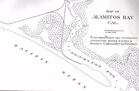
296:1889 map of Alamitos Bay by
189:
7:
316:
10:
551:
452:
267:
256:
175:. It is near Los Angeles.
224:
202:. It is divided from the
178:The bay is named for the
136:
124:
116:
77:
69:
38:
26:
21:
163:, between the cities of
323:Alamitos Bay Yacht Club
171:, at the outlet of the
469:–related article is a
359:California Place Names
251:Alamitos Energy Center
229:Alamitos Bay contains
101:33.74972°N 118.11806°W
73:Long Beach, California
442:. City of Long Beach.
338:Los Cerritos Wetlands
298:Charles Henry Gilbert
200:Long Beach Breakwater
132:Los Cerritos Channel
106:33.74972; -118.11806
151:is an inlet on the
97: /
520:Bays of California
389:. 15 October 2016.
155:coast of southern
33:Alamitos Bay, 2015
482:
481:
204:San Gabriel River
182:word for 'little
173:San Gabriel River
146:
145:
138:Ocean/sea sources
542:
503:
496:
489:
461:
454:
444:
443:
436:
430:
429:
427:
419:
413:
412:
403:Maschke, Alena.
400:
391:
390:
379:
373:
372:
354:
308:
293:
278:
139:
128:
112:
111:
109:
108:
107:
102:
98:
95:
94:
93:
90:
80:
54:
53:
47:
31:
19:
18:
550:
549:
545:
544:
543:
541:
540:
539:
510:
509:
508:
507:
450:
448:
447:
438:
437:
433:
425:
421:
420:
416:
401:
394:
381:
380:
376:
369:
355:
351:
346:
319:
312:
309:
300:
294:
285:
284:at Alamitos Bay
279:
270:
259:
239:
227:
192:
127:Primary inflows
105:
103:
99:
96:
91:
88:
86:
84:
83:
65:
64:
63:
62:
61:
60:
59:
55:
34:
17:
12:
11:
5:
548:
538:
537:
532:
527:
522:
506:
505:
498:
491:
483:
480:
479:
462:
446:
445:
431:
414:
392:
374:
367:
348:
347:
345:
342:
341:
340:
335:
330:
325:
318:
315:
314:
313:
310:
303:
301:
295:
288:
286:
280:
273:
269:
266:
258:
255:
238:
235:
231:Marine Stadium
226:
223:
191:
188:
144:
143:
140:
134:
133:
130:
122:
121:
118:
114:
113:
81:
75:
74:
71:
67:
66:
57:
56:
49:
48:
42:
41:
40:
39:
36:
35:
32:
24:
23:
15:
9:
6:
4:
3:
2:
547:
536:
533:
531:
528:
526:
523:
521:
518:
517:
515:
504:
499:
497:
492:
490:
485:
484:
478:
476:
472:
468:
463:
460:
456:
455:
451:
441:
435:
424:
418:
410:
406:
399:
397:
388:
384:
378:
370:
368:0-520-24217-3
364:
360:
353:
349:
339:
336:
334:
331:
329:
326:
324:
321:
320:
311:1960 postcard
307:
302:
299:
292:
287:
283:
277:
272:
271:
265:
263:
254:
252:
247:
244:
237:Water quality
234:
232:
222:
220:
215:
213:
210:by a pair of
209:
205:
201:
197:
187:
185:
181:
176:
174:
170:
166:
162:
161:United States
158:
154:
153:Pacific Ocean
150:
142:Pacific Ocean
141:
135:
131:
129:
123:
120:Pacific Ocean
119:
115:
110:
82:
76:
72:
68:
46:
37:
30:
25:
20:
475:expanding it
464:
449:
434:
417:
408:
386:
377:
358:
352:
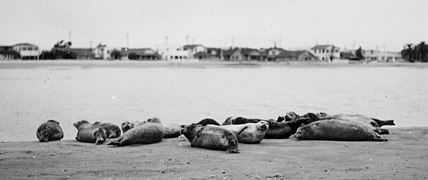
282:Harbor seals
260:
248:
243:Heal the Bay
240:
228:
216:
193:
177:
149:Alamitos Bay
148:
147:
117:Part of
58:Alamitos Bay
22:Alamitos Bay
333:Anaheim Bay
104: /
92:118°07′05″W
79:Coordinates
514:Categories
409:lbpost.com
344:References
208:Seal Beach
169:Seal Beach
165:Long Beach
157:California
89:33°44′59″N
196:Peninsula
190:Geography
317:See also
198:and the
70:Location
268:Gallery
257:Islands
212:jetties
184:poplars
180:Spanish
365:
262:Naples
225:Venues
465:This
426:(PDF)
471:stub
387:KCET
363:ISBN
206:and
167:and
186:'.
516::
407:.
395:^
385:.
221:.
159:,
502:e
495:t
488:v
477:.
428:.
411:.
371:.
Text is available under the Creative Commons Attribution-ShareAlike License. Additional terms may apply.


