53:
93:
29:
100:
60:
299:
in the
Province of Gelderland. As the bordering lakes of Flevoland are strictly speaking one mass of water there are no exact markers on where the Wolderwijd ends and the adjacent lakes start. In the west near Strand Horst the Wolderwijd becomes the
328:, to ensure that the water level of the Veluwe would not drop. The lake receives water from the neighboring Veluwemeer and several streams and sluices. An additional source is low-phosphate water from the Flevopolder to counter
288:
339:
205:
342:
since 29 August 2000. It was designated as such because it held over 1% of relevant biogeographical populations of two bird species, the swan species
407:
301:
147:
52:
452:
377:
92:
335:
The
Wolderwijd lake is used for commercial fishery, boating, shipping traffic, water management, and sand extraction.
447:
246:
472:
467:
295:, in the Province of Flevoland, and on the southern and eastern bank it is encompassed by the municipality of
179:
8:
457:
305:
462:
432:
381:
276:
184:
73:
349:
329:
191:
441:
162:
149:
291:. On the northern and western bank it is encompassed by the municipality of
344:
325:
280:
309:
296:
259:
133:
38:
338:
The lake, together with the
Nuldernauw, has also been designated as a
284:
129:
77:
34:
292:
263:
321:
320:
The lake was created as a buffer between the old land of the
28:
410:. The Ramsar Convention on Wetlands. 12 February 2013
283:, created in 1967 by the gaining of land in Southern
16:Bordering lake in Between Flevoland and Gelderland
372:
370:
368:
439:
140:
365:
408:"The Annotated Ramsar List: The Netherlands"
308:at the provincial road N302 it becomes the
340:Ramsar wetland of international importance
206:Ramsar wetland of international importance
402:
400:
398:
440:
433:Ramsar information sheet on Wolderwijd
395:
13:
99:
59:
14:
484:
426:
237:1.7 m (5 ft 7 in)
98:
91:
58:
51:
27:
453:Ramsar sites in the Netherlands
112:Location within the Netherlands
1:
358:
7:
72:The Wolderwijd amongst the
10:
489:
255:
245:
241:
233:
229:
214:
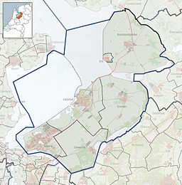
201:
190:
178:
139:
124:
45:
26:
21:
448:Lakes of the Netherlands
33:Wolderwijd as seen from
473:Landforms of Gelderland
304:and in the east at the
115:Show map of Netherlands
468:Landforms of Flevoland
324:and the newly created
315:
289:Veluwe bordering lakes
82:Show map of Flevoland
287:. It is one of four
163:52.34722°N 5.57500°E
251:De Zegge, De Biezen
159: /
76:of the province of
269:
268:
168:52.34722; 5.57500
480:
420:
419:
417:
415:
404:
393:
392:
390:
388:
374:
279:situated in the
225:
223:
210:
174:
173:
171:
170:
169:
164:
160:
157:
156:
155:
152:
142:
116:
102:
101:
95:
83:
62:
61:
55:
37:looking towards
31:
19:
18:
488:
487:
483:
482:
481:
479:
478:
477:
438:
437:
429:
424:
423:
413:
411:
406:
405:
396:
386:
384:
382:Rijkswaterstaat
376:
375:
366:
361:
353:(Aythya ferina)
348:(1.6%) and the
345:Cygnus bewickii
318:
221:
219:
208:
194: countries
167:
165:
161:
158:
153:
150:
148:
146:
145:
120:
119:
118:
117:
114:
113:
110:
109:
108:
107:
103:
86:
85:
84:
81:
80:
74:bordering lakes
70:
69:
68:
67:
63:
41:
17:
12:
11:
5:
486:
476:
475:
470:
465:
460:
455:
450:
436:
435:
428:
427:External links
425:
422:
421:
394:
363:
362:
360:
357:
350:common pochard
330:eutrophication
317:
314:
277:bordering lake
267:
266:
257:
253:
252:
249:
243:
242:
239:
238:
235:
231:
230:
227:
226:
216:
212:
211:
203:
199:
198:
195:
188:
187:
185:Bordering lake
182:
176:
175:
143:
137:
136:
126:
122:
121:
111:
105:
104:
97:
96:
90:
89:
88:
87:
71:
65:
64:
57:
56:
50:
49:
48:
47:
46:
43:
42:
32:
24:
23:
15:
9:
6:
4:
3:
2:
485:
474:
471:
469:
466:
464:
461:
459:
456:
454:
451:
449:
446:
445:
443:
434:
431:
430:
409:
403:
401:
399:
383:
379:
373:
371:
369:
364:
356:
354:
351:
347:
346:
341:
336:
333:
331:
327:
323:
313:
311:
307:
303:
298:
294:
290:
286:
282:
278:
274:
265:
261:
258:
254:
250:
248:
244:
240:
236:
234:Average depth
232:
228:
217:
213:
207:
204:
200:
196:
193:
189:
186:
183:
181:
177:
172:
144:
138:
135:
131:
127:
123:
94:
79:
75:
54:
44:
40:
36:
30:
25:
20:
412:. Retrieved
385:. Retrieved
380:(in Dutch).
378:"Wolderwijd"
352:
343:
337:
334:
319:
272:
270:
326:Flevopolder
281:Netherlands
256:Settlements
202:Designation
197:Netherlands
166: /
141:Coordinates
458:Harderwijk
442:Categories
359:References
310:Veluwemeer
302:Nuldernauw
297:Harderwijk
273:Wolderwijd
260:Harderwijk
151:52°20′50″N
134:Gelderland
106:Wolderwijd
66:Wolderwijd
39:Harderwijk
22:Wolderwijd
285:Flevoland
154:5°34′30″E
130:Flevoland
78:Flevoland
35:Flevoland
463:Zeewolde
355:(2.1%).
306:aqueduct
293:Zeewolde
264:Zeewolde
128:Between
125:Location
247:Islands
220: (
322:Veluwe
209:(2000)
414:7 May
387:7 May
275:is a
215:Built
192:Basin
416:2014
389:2014
271:The
222:1963
218:1963
180:Type
132:and
316:Use
444::
397:^
367:^
332:.
312:.
262:,
418:.
391:.
224:)
Text is available under the Creative Commons Attribution-ShareAlike License. Additional terms may apply.


