31:
224:
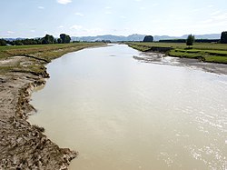
The river has formed the fertile and highly productive
Poverty Bay flats on the edge of Gisborne. The Waipaoa River Flood Control Scheme was built in the 1950s. Stopbanks are to be raised by 2031, as soil erosion, especially from the Waingaromia and Mangatu catchments, has built up the river bed, the
400:
Zeal; Dunbar, Dr Alan Orpin; Dr Alan Palmer; Dr Gavin; Carter, Dr Lionel; Alex, Matthew Wood; Dr Gary Wilson In the USA: Dr Clark; Walsh, Claudia
Venherm; Dr J. P.; Marsaglia, Ben Sumner; Dr Steven Kuehl; Tommy Gerber; Dr Kathleen (1 December 2007).
225:
annual flow of sediment being 15 million tonnes. Despite this pollution, many of the headwaters have indigenous fish. In the lower river, water quality is poor for
92:
375:
427:
245:. The sediment, building up at the rate of several centimetres a year, even many kilometres into Poverty Bay, shows that removal of trees such as
402:
480:
499:
509:
242:
473:
349:
298:
504:
261:
covered areas to farmland by the early 20th century, increased sediment flows by 2 to 3 times the former rate.
466:
182:
254:
323:
250:
246:
178:
8:
238:
214:
186:
454:
446:
421:
202:
226:
198:
170:
64:
450:
277:
493:
218:
206:
194:
190:
107:
94:
166:
230:
174:
149:
85:
258:
234:
210:
30:
209:
rivers. Major settlements along the banks of the river include
185:. The river has several important tributaries, among them the
181:. For about half of this distance its valley is followed by
173:, flowing south for 80 kilometres (50 mi) to reach
399:
376:"Waipaoa River at Matawhero Bridge River Quality"
299:"Environmental monitoring data for Waipaoa River"
491:
474:
165:is a river of the northeast of New Zealand's
426:: CS1 maint: multiple names: authors list (
481:
467:
169:. It rises on the eastern slopes of the
492:
440:
293:
291:
177:and the Pacific Ocean just south of
127:2,165 km (836 sq mi)
13:
445:This article about a river in the
14:
521:
403:"Tracking the Waipaoa out to sea"
288:
380:Land, Air, Water Aotearoa (LAWA)
303:Land, Air, Water Aotearoa (LAWA)
29:
500:Rivers of the Gisborne District
393:
368:
342:
316:
270:
1:
324:"WAIPAOA RIVER CONTROL Press"
264:
51:Physical characteristics
453:. You can help Knowledge by
282:Encyclopaedia of New Zealand
72: • elevation
7:
510:Gisborne Region river stubs
145: • location
10:
526:
439:
76:965 m (3,166 ft)
354:Gisborne District Council
328:paperspast.natlib.govt.nz
155:
143:
135:
131:
123:
84:
80:
70:
59:
55:
50:
42:
37:
28:
23:
350:"Waipaoa Flood Control"
108:38.71331°S 177.94186°E
505:Rivers of New Zealand
257:and then converting
113:-38.71331; 177.94186
16:River in New Zealand
239:ammoniacal nitrogen
104: /
462:
461:
447:Gisborne District
330:. 1 December 1952
159:
158:
517:
483:
476:
469:
441:
432:
431:
425:
417:
415:
413:
397:
391:
390:
388:
386:
372:
366:
365:
363:
361:
346:
340:
339:
337:
335:
320:
314:
313:
311:
309:
295:
286:
285:
274:
243:total phosphorus
146:
119:
118:
116:
115:
114:
109:
105:
102:
101:
100:
97:
73:
33:
21:
20:
525:
524:
520:
519:
518:
516:
515:
514:
490:
489:
488:
487:
437:
435:
419:
418:
411:
409:
398:
394:
384:
382:
374:
373:
369:
359:
357:
356:. 16 March 2023
348:
347:
343:
333:
331:
322:
321:
317:
307:
305:
297:
296:
289:
278:"Waipaoa River"
276:
275:
271:
267:
183:State Highway 2
171:Raukumara Range
144:
112:
110:
106:
103:
98:
95:
93:
91:
90:
71:
65:Raukumara Range
17:
12:
11:
5:
523:
513:
512:
507:
502:
486:
485:
478:
471:
463:
460:
459:
434:
433:
392:
367:
341:
315:
287:
268:
266:
263:
157:
156:
153:
152:
147:
141:
140:
137:
133:
132:
129:
128:
125:
121:
120:
88:
82:
81:
78:
77:
74:
68:
67:
61:
57:
56:
53:
52:
48:
47:
44:
40:
39:
35:
34:
26:
25:
15:
9:
6:
4:
3:
2:
522:
511:
508:
506:
503:
501:
498:
497:
495:
484:
479:
477:
472:
470:
465:
464:
458:
456:
452:
448:
443:
442:
438:
429:
423:
408:
404:
396:
381:
377:
371:
355:
351:
345:
329:
325:
319:
304:
300:
294:
292:
283:
279:
273:
269:
262:
260:
256:
252:
248:
244:
240:
236:
232:
228:
222:
220:
216:
212:
208:
204:
200:
196:
192:
188:
184:
180:
176:
172:
168:
164:
163:Waipaoa River
154:
151:
148:
142:
138:
134:
130:
126:
122:
117:
89:
87:
83:
79:
75:
69:
66:
63:Kererūhuahua
62:
58:
54:
49:
45:
41:
36:
32:
27:
24:Waipaoa River
22:
19:
455:expanding it
444:
436:
410:. Retrieved
406:
395:
383:. Retrieved
379:
370:
358:. Retrieved
353:
344:
332:. Retrieved
327:
318:
306:. Retrieved
302:
281:
272:
223:
167:North Island
162:
160:
18:
203:Waingaromia
175:Poverty Bay
150:Poverty Bay
111: /
99:177°56′31″E
46:New Zealand
494:Categories
265:References
255:kaihikatea
187:Wharekōpae
124:Basin size
96:38°42′48″S
235:turbidity
211:Te Karaka
136:Discharge
422:cite web
412:26 March
385:26 March
360:26 March
334:25 March
308:25 March
219:Pātūtahi
179:Gisborne
38:Location
284:. 1966.
231:clarity
227:E. coli
207:Waihora
199:Te Ārai
195:Mangatu
191:Waikohu
43:Country
217:, and
215:Ormond
139:
60:Source
449:is a
251:matai
86:Mouth
451:stub
428:link
414:2023
407:NIWA
387:2023
362:2023
336:2023
310:2023
259:fern
253:and
247:rimu
241:and
205:and
161:The
496::
424:}}
420:{{
405:.
378:.
352:.
326:.
301:.
290:^
280:.
249:,
237:,
233:,
229:,
221:.
213:,
201:,
197:,
193:,
189:,
482:e
475:t
468:v
457:.
430:)
416:.
389:.
364:.
338:.
312:.
Text is available under the Creative Commons Attribution-ShareAlike License. Additional terms may apply.
