614:
64:
51:
220:
was split off from Urambo
District. That is why the population of Urambo District declined in this period. According to the 2012 Tanzania National Census, the population of Urambo District was 192,781.
575:
503:
191:
404:
346:
655:
269:
425:
455:
674:
679:
496:
365:
648:
489:
380:
203:
641:
213:
According to the 2002 Tanzania
National Census, the population of the Urambo District was 260,322.
241:
408:
551:
512:
127:
33:
8:
629:
76:
481:
186:
In the 19th century, Urambo was a kingdom. It came about under the leadership of King
167:
433:
546:
147:
536:
531:
273:
217:
139:
625:
541:
463:
381:"Urambo (District, Tanzania) - Population Statistics, Charts, Map and Location"
190:, who united the territory of Uyowa, which had been ruler by his father, with
668:
621:
590:
577:
561:
516:
245:
151:
143:
131:
81:
613:
520:
135:
69:
187:
42:
268:
was administratively divided into 26 wards. As of 2012, only 16
50:
253:
249:
234:
230:
155:
347:
Urambo
District Homepage for the 2002 Tanzania National Census
252:- passes through the district. There is a train station in
511:
405:"2002 Population and Housing Census: Tabora: Urambo"
178:, a 19th century kingdom of the Nyamwezi people.
666:
649:
497:
420:
418:
656:
642:
504:
490:
415:
154:. Its administrative seat is the town of
667:
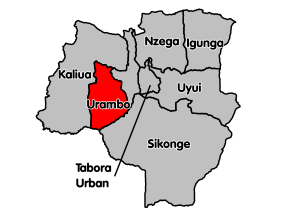
138:. It is bordered to the north by the
485:
96:5,415 km (2,091 sq mi)
608:
19:District in Tabora Region, Tanzania
16:District of Tabora Region, Tanzania
13:
14:
691:
612:
202:Southern Urambo district is the
62:
49:
367:Dictionary of African Biography
208:
448:
397:
373:
359:
150:, and to the southwest by the
1:
430:National Bureau of Statistics
352:
259:
237:passes through the district.
628:. You can help Knowledge by
229:Unpaved Trunk road T18 from
197:
161:
7:
10:
696:
675:Districts of Tabora Region
607:
340:
331:Vumilia (English meaning:
224:
204:Ugalla River National Park
181:
146:, to the southeast by the
41:Etymology: named for King
527:
113:
105:
100:
92:
87:
75:
57:
48:
40:
31:
24:
680:Tanzania geography stubs
279:
216:Between 2002 and 2012,
624:location article is a
117:48/km (120/sq mi)
385:www.citypopulation.de
142:, to the east by the
126:is one of the seven
114: • Density
587: /
166:The name "Urambo" (
176:Home of the Urambo
106: • Total
93: • Total
637:
636:
570:
569:
168:Nyamwezi language
121:
120:
687:
658:
651:
644:
616:
609:
602:
601:
599:
598:
597:
592:
591:5.000°S 31.917°E
588:
585:
584:
583:
580:
552:Tabora Municipal
506:
499:
492:
483:
482:
476:
475:
473:
471:
462:. Archived from
452:
446:
445:
443:
441:
432:. Archived from
422:
413:
412:
407:. Archived from
401:
395:
394:
392:
391:
377:
371:
363:
148:Sikonge District
68:
66:
65:
53:
22:
21:
695:
694:
690:
689:
688:
686:
685:
684:
665:
664:
663:
662:
605:
595:
593:
589:
586:
581:
578:
576:
574:
573:
571:
566:
523:
510:
480:
479:
469:
467:
466:on 3 April 2016
456:"Road Networks"
454:
453:
449:
439:
437:
436:on 5 March 2016
424:
423:
416:
403:
402:
398:
389:
387:
379:
378:
374:
364:
360:
355:
343:
338:
282:
276:was split off.
274:Kaliua District
272:remained after
266:Urambo District
262:
227:
218:Kaliua District
211:
200:
184:
164:
140:Kaliua District
63:
61:
36:
27:
20:
17:
12:
11:
5:
693:
683:
682:
677:
661:
660:
653:
646:
638:
635:
634:
617:
596:-5.000; 31.917
568:
567:
565:
564:
559:
554:
549:
544:
539:
534:
528:
525:
524:
509:
508:
501:
494:
486:
478:
477:
447:
414:
411:on 2008-11-18.
396:
372:
357:
356:
354:
351:
350:
349:
342:
339:
337:
336:
329:
326:
323:
320:
317:
314:
311:
308:
305:
302:
299:
296:
293:
290:
287:
283:
281:
278:
261:
258:
240:The Tanzanian
226:
223:
210:
207:
199:
196:
183:
180:
163:
160:
119:
118:
115:
111:
110:
107:
103:
102:
98:
97:
94:
90:
89:
85:
84:
79:
73:
72:
59:
55:
54:
46:
45:
38:
37:
32:
29:
28:
25:
18:
15:
9:
6:
4:
3:
2:
692:
681:
678:
676:
673:
672:
670:
659:
654:
652:
647:
645:
640:
639:
633:
631:
627:
623:
622:Tabora Region
618:
615:
611:
610:
606:
603:
600:
563:
560:
558:
555:
553:
550:
548:
545:
543:
540:
538:
535:
533:
530:
529:
526:
522:
518:
517:Tabora Region
514:
507:
502:
500:
495:
493:
488:
487:
484:
465:
461:
457:
451:
435:
431:
427:
426:"Census 2012"
421:
419:
410:
406:
400:
386:
382:
376:
370:
368:
362:
358:
348:
345:
344:
334:
330:
327:
324:
321:
318:
315:
312:
309:
306:
303:
300:
297:
294:
291:
288:
285:
284:
277:
275:
271:
267:
257:
255:
251:
247:
246:Dar es Salaam
244:train - from
243:
238:
236:
232:
222:
219:
214:
206:
205:
195:
193:
189:
179:
177:
173:
169:
159:
157:
153:
152:Katavi Region
149:
145:
144:Uyui District
141:
137:
133:
132:Tabora Region
129:
125:
116:
112:
108:
104:
99:
95:
91:
86:
83:
82:Tabora Region
80:
78:
74:
71:
60:
56:
52:
47:
44:
39:
35:
30:
23:
630:expanding it
619:
604:
572:
556:
468:. Retrieved
464:the original
459:
450:
438:. Retrieved
434:the original
429:
409:the original
399:
388:. Retrieved
384:
375:
366:
361:
332:
265:
263:
242:Central Line
239:
228:
215:
212:
209:Demographics
201:
185:
175:
171:
165:
123:
122:
594: /
470:23 February
440:29 February
286:Imalamakoye
669:Categories
390:2024-02-11
353:References
310:Ukondamoyo
304:Songambele
260:Government
192:Ulyankhulu
101:Population
513:Districts
264:In 2002,
198:Geography
162:Etymology
128:districts
521:Tanzania
460:Tanroads
369:, p. 224
333:tolerate
298:Muungano
295:Kiloleni
289:Kapilula
174:meaning
136:Tanzania
70:Tanzania
34:District
582:31°55′E
547:Sikonge
341:Sources
225:Economy
188:Mirambo
182:History
130:of the
109:260,322
58:Country
43:Mirambo
579:5°00′S
557:Urambo
537:Kaliua
532:Igunga
328:Uyumbu
322:Itundu
319:Ussoke
316:Usisya
313:Urambo
307:Ugalla
301:Nsenda
292:Kasisi
256:town.
254:Urambo
250:Kigoma
235:Kigoma
231:Tabora
156:Urambo
124:Urambo
77:Region
67:
26:Urambo
620:This
542:Nzega
325:Uyogo
280:Wards
270:wards
626:stub
562:Uyui
472:2016
442:2016
88:Area
515:of
248:to
233:to
134:of
671::
519:,
458:.
428:.
417:^
383:.
194:.
170::
158:.
657:e
650:t
643:v
632:.
505:e
498:t
491:v
474:.
444:.
393:.
335:)
172:)
Text is available under the Creative Commons Attribution-ShareAlike License. Additional terms may apply.
