38:
334:
50:
262:
The river passes under Ing Bridge as it continues in a southerly direction down the
Troutbeck valley through the tranquil fields of the valley bottom. The hamlets of Town Head and High Green are just to the west of the river as it enters Limefitt Park. On emerging from Limefitt the river is bridged
235:
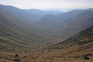
Several tributaries flowing from the crags to the west of the High Street Roman road combine to form the young Trout Beck. The river descends rapidly, more or less in a southerly direction, through
244:
256:
248:
252:
289:
From its source the Trout Beck descends some 1,840 feet (560 m) in a distance of about seven miles (11 km). The river is a
409:
274:
village lies on the west side of the valley. Continuing through a narrow area of mixed woodland the river eventually reaches the
286:. After less than a mile (2 km) the river enters Windermere on its eastern shore at a point close to Calgarth Hall.
259:
at the 460 feet (140 m) contour. This latter tributary drains the fells around the course of the old Roman road.
37:
384:
305:
229:
20:
19:
This article is about the beck which flows into
Windermere. For the tributary of the Glenderamackin, see
458:
448:
283:
271:
91:
453:
255:, is subsumed. The engorged Trout Beck then skirts Hird Wood on its eastern side before subsuming
313:
354:
209:
8:
298:
201:
225:
279:
240:
95:
221:
114:
339:
267:
236:
442:
424:
411:
359:
197:
55:
364:
349:
309:
294:
147:
205:
152:
333:
275:
264:
213:
317:
297:
can be caught. Anglers should enquire locally about licences (an
126:
81:
71:
49:
193:
290:
232:
range, at a height of about 1,970 feet (600 m).
204:. It is one of the main sources of replenishment for
329:
243:. At a height of about 650 feet (200 m) the
440:
312:, and since 1974, has also been in the
220:. The river rises between the peaks of
441:
216:and appears in documents from 1292 as
54:Trout Beck, highlighted in orange, in
377:
304:The Trout Beck is wholly within the
13:
42:Trout Beck from Thresthwaite Mouth
14:
470:
247:, draining the eastern flanks of
332:
48:
36:
212:catchment. Its name comes from
1:
370:
102:Physical characteristics
170: • elevation
134: • elevation
7:
323:
160: • location
122: • location
21:Trout Beck (Glenderamackin)
10:
475:
301:Rod Licence is required).
182:8.3 mi (13.4 km)
138:1,970 ft (600 m)
18:
16:Stream in Cumbria, England
178:
168:
158:
146:
142:
132:
120:
110:
106:
101:
87:
77:
67:
62:
47:
35:
30:
389:Catchment Data Explorer
174:128 ft (39 m)
314:administrative county
208:, and is part of the
391:. Environment Agency
421: /
239:and to the west of
425:54.4128°N 2.9115°W
299:Environment Agency
202:North West England
192:is a fast flowing
459:Beck watercourses
449:Rivers of Cumbria
282:near the town of
226:Thornthwaite Crag
186:
185:
164:Calgarth, Cumbria
466:
436:
435:
433:
432:
431:
430:54.4128; -2.9115
426:
422:
419:
418:
417:
414:
401:
400:
398:
396:
381:
342:
337:
336:
280:Troutbeck Bridge
241:Troutbeck Tongue
135:
123:
96:Troutbeck Bridge
52:
40:
28:
27:
474:
473:
469:
468:
467:
465:
464:
463:
454:Leven catchment
439:
438:
429:
427:
423:
420:
415:
412:
410:
408:
407:
405:
404:
394:
392:
383:
382:
378:
373:
346:
345:
338:
331:
326:
306:historic county
222:Stony Cove Pike
171:
161:
133:
121:
115:Stony Cove Pike
58:
43:
24:
17:
12:
11:
5:
472:
462:
461:
456:
451:
403:
402:
375:
374:
372:
369:
368:
367:
362:
357:
352:
344:
343:
340:Cumbria portal
328:
327:
325:
322:
293:fishery where
268:Kirkstone Pass
237:Troutbeck Park
184:
183:
180:
176:
175:
172:
169:
166:
165:
162:
159:
156:
155:
150:
144:
143:
140:
139:
136:
130:
129:
124:
118:
117:
112:
108:
107:
104:
103:
99:
98:
89:
85:
84:
79:
75:
74:
69:
65:
64:
60:
59:
53:
45:
44:
41:
33:
32:
15:
9:
6:
4:
3:
2:
471:
460:
457:
455:
452:
450:
447:
446:
444:
437:
434:
390:
386:
380:
376:
366:
363:
361:
360:River Brathay
358:
356:
353:
351:
348:
347:
341:
335:
330:
321:
319:
315:
311:
307:
302:
300:
296:
292:
287:
285:
281:
277:
273:
269:
266:
260:
258:
254:
250:
246:
245:Woundale Beck
242:
238:
233:
231:
227:
223:
219:
215:
211:
207:
203:
199:
198:Lake District
195:
191:
181:
177:
173:
167:
163:
157:
154:
151:
149:
145:
141:
137:
131:
128:
125:
119:
116:
113:
109:
105:
100:
97:
93:
90:
86:
83:
80:
76:
73:
70:
66:
61:
57:
56:OpenStreetMap
51:
46:
39:
34:
29:
26:
22:
406:
393:. Retrieved
388:
385:"Trout Beck"
379:
365:River Rothay
303:
288:
261:
234:
217:
189:
187:
25:
428: /
355:River Leven
350:Cunsey Beck
310:Westmorland
295:brown trout
230:High Street
443:Categories
413:54°24′46″N
371:References
284:Windermere
206:Windermere
190:Trout Beck
153:Windermere
31:Trout Beck
416:2°54′41″W
276:A591 road
272:Troutbeck
257:Hagg Gill
249:Broad End
214:Old Norse
92:Troutbeck
395:18 April
324:See also
253:Pike How
218:Trutebyk
88:Villages
63:Location
318:Cumbria
263:by the
228:in the
196:of the
127:Cumbria
82:Cumbria
72:England
68:Country
270:road.
194:stream
179:Length
111:Source
78:County
291:trout
210:Leven
148:Mouth
397:2016
265:A592
251:and
224:and
188:The
316:of
308:of
278:at
200:in
445::
387:.
320:.
94:,
399:.
23:.
Text is available under the Creative Commons Attribution-ShareAlike License. Additional terms may apply.

