313:
352:
towers on either end. The bridge cost $ 120 million, designed by
Hardesty & Hanover LLP of New York City, is 90 feet (27 m) wide and 270 feet (82 m) long with two 30-foot (9.1 m) tower spans and six 100-foot (30 m)-long approach spans. The lift span weighs almost 6,500,000 pounds (2,900,000 kg) with a total load-to-move of 13,000,000 pounds (5,900,000 kg). It provides a channel with 240 feet (73 m) horizontal clearance and 13 feet (4.0 m) vertical clearance when the span is closed, and an additional 62 feet (19 m) vertical clearance when it is open.
31:
552:
95:
336:, it was carrying 30,000 vehicles a day. When closed, clearance under the bridge was 12 feet (3.7 m) at mean high water, ranging from 8–17 feet (2.4–5.2 m) at extreme high tide to extreme low tide. The channel width was 117 feet (36 m), with a total span length between centers of 148 feet (45 m). The builder was the
359:
Securing the bridge's lift piers initially proved difficult because rock elevation and slope differed along the route. To secure the piers, teeth were welded to the tip of 20-in-diameter pile shells that were then drilled into the bedrock. For some piles, an adequate seal was not achieved until the
351:
270 feet (82 m) long and 92 feet (28 m) wide, a significant improvement from the previous (third) bridge's 117-foot (36 m) channel. The mechanism raises the lift span 62 feet (19 m) with 3,000,000-pound (1,400,000 kg) counterweights on each of the two 150-foot (46 m)
300:
The first bridge here was erected in 1797 by Isaac
Tomlinson's group to replace profits from their ferry ruined by a new bridge. This 27-foot (8.2 m)-wide covered wooden truss bridge included a draw to allow vessels through. It has also been described as a "wood and sandstone" bridge.
304:
The second bridge, 1885-1922, was an iron bridge which was never particularly good, having been salvaged from a scrap yard, and not thought well of even before then. By 1913, this bridge was opening 17,000 times a year. Plans for replacement were created during
369:
312:
328:
with its counterweights in a closed pit underneath, built between 1921 and 1924. It was designed by engineer Ernest W. Wiggin of New Haven in the Beaux-Arts style, based on a bascule design by
48:
618:
603:
598:
628:
563:
633:
588:
613:
356:
623:
638:
583:
142:
556:
374:
608:
277:
102:
536:
467:
127:
568:
Tomlinson Bridge, Spanning
Quinnipiac River at Forbes Street (U.S. Route 1), New Haven, New Haven County, CT
41:
98:
341:
269:
414:
337:
265:
123:
593:
285:
238:
157:
8:
281:
370:
List of bridges documented by the
Historic American Engineering Record in Connecticut
329:
30:
273:
261:
113:
325:
577:
214:
Nicholas J. Altebrando, Thomas A. Duffy, Michael D. Hawkins, Timothy J. Noles
64:
50:
272:. The Tomlinson Vertical Lift Bridge carries four lanes of traffic across
348:
306:
131:
567:
419:
333:
570:", 46 photos, 36 data pages, 6 photo caption pages
321:
292:. A sidewalk is present along the southern edge of the bridge.
551:
167:
289:
347:
The current bridge, the fourth one on this site, is a
619:
Bridges of the United States
Numbered Highway System
604:
Historic
American Engineering Record in Connecticut
599:Buildings and structures in New Haven, Connecticut
360:pile had been seated into 5 ft. of bedrock.
575:
462:
460:
458:
410:
357:New Haven Harbor Crossing Improvement Program
276:and a single-track freight line owned by the
408:
406:
404:
402:
400:
398:
396:
394:
392:
390:
455:
629:Vertical lift bridges in the United States
387:
332:. Before the completion of the adjacent
634:Bridges in New Haven County, Connecticut
589:Transportation in New Haven, Connecticut
514:
512:
510:
491:
489:
487:
485:
448:
446:
444:
442:
440:
430:
428:
311:
614:Road-rail bridges in the United States
576:
521:
375:List of movable bridges in Connecticut
280:that connects the waterfront with the
507:
498:
482:
437:
425:
564:Historic American Engineering Record
35:Tomlinson Lift Bridge in August 2022
16:Bridge in Connecticut, United States
537:Tomlinson bridge construction notes
278:Providence & Worcester Railroad
103:Providence & Worcester Railroad
13:
624:Steel bridges in the United States
468:"Cianbro Bridges Quinnipiac River"
14:
650:
639:Providence and Worcester Railroad
545:
550:
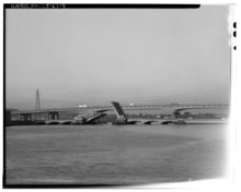
320:The third bridge on-site was a
268:. The bridge forms a segment of
93:
29:
584:Railroad bridges in Connecticut
530:
470:. Construction Equipment Guide
316:Third bridge, partially raised
1:
380:
355:The project was part of the
7:
609:Road bridges in Connecticut
363:
206:Hardesty & Hanover, LLP
10:
655:
342:Philadelphia, Pennsylvania
295:
177:283.5 metres (930 ft)
250:
245:
234:
226:
218:
210:
202:
197:
193:82.3 metres (270 ft)
189:
181:
173:
163:
153:
148:
138:
119:
109:
88:
40:
28:
21:
566:(HAER) No. CT-61, "
65:41.298296°N 72.905292°W
338:Phoenix Bridge Company
317:
266:New Haven, Connecticut
230:1797, 1885, 1924, 2002
185:28 metres (92 ft)
559:at Wikimedia Commons
557:Tomlinson Lift Bridge
415:Tomlinson Lift Bridge
315:
260:is a crossing of the
258:Tomlinson Lift Bridge
211:Engineering design by
76:Tomlinson Lift Bridge
70:41.298296; -72.905292
23:Tomlinson Lift Bridge
158:Vertical-lift bridge
60: /
326:bascule drawbridge
318:
282:Northeast Corridor
219:Construction start
555:Media related to
527:HAER data page 13
330:Joseph B. Strauss
254:
253:
235:Construction cost
646:
554:
539:
534:
528:
525:
519:
518:HAER data page 6
516:
505:
504:HAER data page 7
502:
496:
495:HAER data page 5
493:
480:
479:
477:
475:
464:
453:
452:HAER data page 4
450:
435:
434:HAER data page 2
432:
423:
412:
274:New Haven Harbor
262:Quinnipiac River
227:Construction end
128:New Haven County
114:Quinnipiac River
97:
96:
84:
83:
81:
80:
79:
77:
72:
71:
66:
61:
58:
57:
56:
53:
33:
19:
18:
654:
653:
649:
648:
647:
645:
644:
643:
574:
573:
548:
543:
542:
535:
531:
526:
522:
517:
508:
503:
499:
494:
483:
473:
471:
466:
465:
456:
451:
438:
433:
426:
413:
388:
383:
366:
298:
149:Characteristics
134:, United States
94:
75:
73:
69:
67:
63:
62:
59:
54:
51:
49:
47:
46:
36:
24:
17:
12:
11:
5:
652:
642:
641:
636:
631:
626:
621:
616:
611:
606:
601:
596:
591:
586:
572:
571:
547:
546:External links
544:
541:
540:
529:
520:
506:
497:
481:
454:
436:
424:
385:
384:
382:
379:
378:
377:
372:
365:
362:
297:
294:
252:
251:
248:
247:
243:
242:
236:
232:
231:
228:
224:
223:
220:
216:
215:
212:
208:
207:
204:
200:
199:
195:
194:
191:
187:
186:
183:
179:
178:
175:
171:
170:
165:
161:
160:
155:
151:
150:
146:
145:
140:
136:
135:
121:
117:
116:
111:
107:
106:
92:four lanes of
90:
86:
85:
44:
38:
37:
34:
26:
25:
22:
15:
9:
6:
4:
3:
2:
651:
640:
637:
635:
632:
630:
627:
625:
622:
620:
617:
615:
612:
610:
607:
605:
602:
600:
597:
595:
592:
590:
587:
585:
582:
581:
579:
569:
565:
562:
561:
560:
558:
553:
538:
533:
524:
515:
513:
511:
501:
492:
490:
488:
486:
469:
463:
461:
459:
449:
447:
445:
443:
441:
431:
429:
422:
421:
416:
411:
409:
407:
405:
403:
401:
399:
397:
395:
393:
391:
386:
376:
373:
371:
368:
367:
361:
358:
353:
350:
345:
343:
339:
335:
331:
327:
323:
314:
310:
308:
302:
293:
291:
287:
283:
279:
275:
271:
267:
263:
259:
249:
244:
241:$ 125,000,000
240:
237:
233:
229:
225:
221:
217:
213:
209:
205:
201:
196:
192:
188:
184:
180:
176:
172:
169:
166:
162:
159:
156:
152:
147:
144:
141:
137:
133:
129:
125:
122:
118:
115:
112:
108:
104:
101:, 1 track of
100:
91:
87:
82:
45:
43:
39:
32:
27:
20:
594:U.S. Route 1
549:
532:
523:
500:
472:. Retrieved
418:
354:
346:
324:double-leaf
319:
303:
299:
270:U.S. Route 1
257:
255:
190:Longest span
174:Total length
349:lift bridge
307:World War I
286:Metro North
132:Connecticut
68: /
42:Coordinates
578:Categories
474:16 January
420:Structurae
381:References
105:, sidewalk
74: (
55:72°54′19″W
52:41°17′54″N
322:trunioned
124:New Haven
99:US 1
364:See also
334:Q Bridge
284:line of
246:Location
203:Designer
164:Material
296:History
198:History
143:ConnDOT
110:Crosses
89:Carries
154:Design
120:Locale
182:Width
168:Steel
139:Owner
476:2015
288:and
256:The
222:1922
417:at
340:of
290:CSX
264:in
239:USD
580::
509:^
484:^
457:^
439:^
427:^
389:^
344:.
309:.
130:,
126:,
478:.
78:)
Text is available under the Creative Commons Attribution-ShareAlike License. Additional terms may apply.