29:
41:
393:
The South Fork
Solomon River travels across Graham County roughly following the course of Highway 24. The South Fork Solomon River enters Graham County about ½ mile (0.8 km) south of
189:
575:
555:
580:
560:
590:
585:
550:
112:
570:
534:
481:
565:
457:
433:
441:
383:
375:
98:
387:
379:
494:
422:
8:
175:
426:
406:
398:
326:
517:
U.S. Geological Survey. National
Hydrography Dataset high-resolution flowline data.
482:
U.S. Geological Survey
Geographic Names Information System: South Fork Solomon River
418:
314:
260:
414:
410:
394:
322:
544:
445:
402:
363:
347:
310:
204:
191:
127:
114:
59:
495:"Water-Data Report 2007 - 06873460 South Fork Solomon River at Woodston, KS"
437:
343:
318:
163:
45:
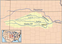
Map of the Smoky Hill drainage basin including the South Fork
Solomon River
28:
518:
158:
351:
359:
40:
397:
and exits Graham County about 5 miles (8.0 km) southwest of
355:
69:
339:
256:
537:at the Solomon Valley Highway 24 Heritage Alliance
417:and Studley, and is impounded eight miles west of
542:
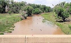
33:South Fork Solomon River above Webster Reservoir
350:. The entire length of the river lies in the
39:
543:
477:
475:
473:
374:The South Fork Solomon River rises in
292:7,260 cu ft/s (206 m/s)
272:40.5 cu ft/s (1.15 m/s)
470:
13:
511:
14:
602:
576:Rivers of Sheridan County, Kansas
556:Rivers of Mitchell County, Kansas
528:
338:is a 292-mile-long (470 km)
581:Rivers of Sherman County, Kansas
561:Rivers of Osborne County, Kansas
282:0 cu ft/s (0 m/s)
27:
591:Tributaries of the Kansas River
586:Rivers of Thomas County, Kansas
551:Rivers of Graham County, Kansas
571:Rivers of Rooks County, Kansas
487:
183: • coordinates
106: • coordinates
16:River in Kansas, United States
1:
463:
378:, and flows eastward through
76:Physical characteristics
369:
222: • elevation
149:3,503 ft (1,068 m)
145: • elevation
7:
451:
252: • location
171: • location
94: • location
10:
607:
484:. Retrieved on 2008-07-22.
288: • maximum
278: • minimum
268: • average
226:1,453 ft (443 m)
521:, accessed March 29, 2011
432:The river then joins the
401:. The river runs through
305:
300:
296:
286:
276:
266:
250:
242:
238:
234:292 mi (470 km)
230:
220:
181:
169:
157:
153:
143:
104:
92:
84:
80:
75:
65:
55:
50:
38:
26:
21:
535:About the Solomon Valley
500:. U.S. Geological Survey
458:List of rivers of Kansas
434:North Fork Solomon River
336:South Fork Solomon River
22:South Fork Solomon River
376:Sherman County, Kansas
128:39.24583°N 101.44611°W
99:Sherman County, Kansas
205:39.47306°N 98.43333°W
133:39.24583; -101.44611
309:South Fork Solomon-
301:Basin features
210:39.47306; -98.43333
201: /
176:Cawker City, Kansas
124: /
425:to form the large
427:Webster Reservoir
332:
331:
598:
566:Rivers of Kansas
522:
519:The National Map
515:
509:
508:
506:
505:
499:
491:
485:
479:
440:in northwestern
419:Stockton, Kansas
289:
279:
269:
253:
216:
215:
213:
212:
211:
206:
202:
199:
198:
197:
194:
146:
139:
138:
136:
135:
134:
129:
125:
122:
121:
120:
117:
107:
95:
43:
31:
19:
18:
606:
605:
601:
600:
599:
597:
596:
595:
541:
540:
531:
526:
525:
516:
512:
503:
501:
497:
493:
492:
488:
480:
471:
466:
454:
442:Mitchell County
372:
342:in the central
287:
277:
267:
251:
223:
209:
207:
203:
200:
195:
192:
190:
188:
187:
184:
172:
144:
132:
130:
126:
123:
118:
115:
113:
111:
110:
105:
93:
46:
34:
17:
12:
11:
5:
604:
594:
593:
588:
583:
578:
573:
568:
563:
558:
553:
539:
538:
530:
529:External links
527:
524:
523:
510:
486:
468:
467:
465:
462:
461:
460:
453:
450:
444:, forming the
386:counties into
371:
368:
330:
329:
307:
303:
302:
298:
297:
294:
293:
290:
284:
283:
280:
274:
273:
270:
264:
263:
254:
248:
247:
244:
240:
239:
236:
235:
232:
228:
227:
224:
221:
218:
217:
185:
182:
179:
178:
173:
170:
167:
166:
161:
155:
154:
151:
150:
147:
141:
140:
108:
102:
101:
96:
90:
89:
86:
82:
81:
78:
77:
73:
72:
67:
63:
62:
57:
53:
52:
48:
47:
44:
36:
35:
32:
24:
23:
15:
9:
6:
4:
3:
2:
603:
592:
589:
587:
584:
582:
579:
577:
574:
572:
569:
567:
564:
562:
559:
557:
554:
552:
549:
548:
546:
536:
533:
532:
520:
514:
496:
490:
483:
478:
476:
474:
469:
459:
456:
455:
449:
447:
446:Solomon River
443:
439:
435:
430:
428:
424:
420:
416:
412:
408:
404:
400:
396:
391:
389:
388:Graham County
385:
381:
377:
367:
365:
364:Solomon River
361:
357:
353:
349:
348:North America
345:
341:
337:
328:
324:
320:
316:
312:
308:
304:
299:
295:
291:
285:
281:
275:
271:
265:
262:
258:
255:
249:
245:
241:
237:
233:
229:
225:
219:
214:
186:
180:
177:
174:
168:
165:
162:
160:
156:
152:
148:
142:
137:
109:
103:
100:
97:
91:
87:
83:
79:
74:
71:
68:
64:
61:
60:United States
58:
54:
49:
42:
37:
30:
25:
20:
513:
502:. Retrieved
489:
438:Waconda Lake
431:
423:Rooks County
392:
373:
344:Great Plains
335:
333:
261:Woodston, KS
259:06873460 at
164:Waconda Lake
327:Mississippi
208: /
131: /
119:101°26′46″W
545:Categories
504:2015-10-20
464:References
358:. It is a
352:U.S. state
315:Smoky Hill
306:Watersheds
196:98°26′00″W
193:39°28′23″N
116:39°14′45″N
407:Hill City
399:Nicodemus
370:Geography
360:tributary
243:Discharge
452:See also
384:Sheridan
323:Missouri
51:Location
415:Morland
411:Penokee
395:Studley
362:of the
311:Solomon
56:Country
380:Thomas
356:Kansas
319:Kansas
246:
231:Length
88:
85:Source
70:Kansas
498:(PDF)
403:Bogue
340:river
159:Mouth
66:State
382:and
334:The
257:USGS
436:at
421:in
354:of
346:of
547::
472:^
448:.
429:.
413:,
409:,
405:,
390:.
366:.
507:.
325:-
321:-
317:-
313:-
Text is available under the Creative Commons Attribution-ShareAlike License. Additional terms may apply.

