315:
355:
343:
327:
131:
374:
32:
299:
purchased the former land grant ranch in 1998 and
Arizona established the "San Rafael State Natural Area" in the valley in 1999 on the southern part of that property. The protected areas are not open to the public. The land grant is privately owned. The State Natural Area is south of the land
314:
444:
326:
459:
354:
342:
204:
42:
100:
72:
305:
79:
86:
432:
57:
68:
197:
464:
469:
273:
253:
240:
387:
269:
392:
93:
333:
53:
8:
257:
189:
296:
265:
184:
135:
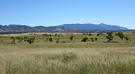
The San Rafael Valley, facing east toward the Canelo Hills and the
Huachuca Mountains.
426:
301:
292:
285:
169:
20:
130:
379:
291:
The San Rafael de la Zanja Land Grant lies in the valley center just north of
453:
219:
206:
149:
49:
261:
179:
412:
31:
320:
View across the San Rafael Valley towards the
Huachuca Mountains.
159:
413:"Arizona State Parks and Trails: San Rafael State Natural Area"
281:
277:
369:
451:
405:
252:is a high intermontane grass valley in eastern
308:as the "San Rafael Ranch Historic District".
58:introducing citations to additional sources
256:. The valley is bounded to the west by the
300:grant, and borders Mexico. In 2008, the
272:. The valley forms the headwaters of the
48:Relevant discussion may be found on the
460:Landforms of Santa Cruz County, Arizona
445:San Rafael State Natural Area – Arizona
452:
19:For the geologic feature in Utah, see
16:Landform in Santa Cruz County, Arizona
348:Cattle grazing in San Rafael Valley.
306:National Register of Historic Places
260:, to the north and northeast by the
25:
13:
14:
481:
372:
353:
341:
325:
313:
129:
41:relies largely or entirely on a
30:
332:The San Rafael Valley with the
304:headquarters was added to the
1:
398:
360:Cattle next to a water tank.
7:
365:
10:
486:
431:: CS1 maint: url-status (
284:just east of the historic
254:Santa Cruz County, Arizona
18:
236:
196:
175:
165:
155:
145:
140:
128:
123:
388:Cienega Valley (Arizona)
276:which flows south into
264:and to the east by the
393:Sulphur Springs Valley
220:31.38333°N 110.58389°W
334:Santa Rita Mountains
225:31.38333; -110.58389
54:improve this article
258:Patagonia Mountains
216: /
190:Patagonia Mountains
69:"San Rafael Valley"
465:Valleys of Arizona
336:in the background.
297:Nature Conservancy
266:Huachuca Mountains
185:Huachuca Mountains
470:Chihuahuan Desert
250:San Rafael Valley
246:
245:
124:San Rafael Valley
119:
118:
104:
477:
437:
436:
430:
422:
420:
419:
409:
382:
377:
376:
375:
357:
345:
329:
317:
302:San Rafael Ranch
274:Santa Cruz River
241:Santa Cruz River
231:
230:
228:
227:
226:
221:
217:
214:
213:
212:
209:
133:
121:
120:
114:
111:
105:
103:
62:
34:
26:
21:San Rafael Swell
485:
484:
480:
479:
478:
476:
475:
474:
450:
449:
441:
440:
424:
423:
417:
415:
411:
410:
406:
401:
378:
373:
371:
368:
361:
358:
349:
346:
337:
330:
321:
318:
224:
222:
218:
215:
210:
207:
205:
203:
202:
188:
183:
136:
115:
109:
106:
63:
61:
47:
35:
24:
17:
12:
11:
5:
483:
473:
472:
467:
462:
448:
447:
439:
438:
403:
402:
400:
397:
396:
395:
390:
384:
383:
380:Arizona portal
367:
364:
363:
362:
359:
352:
350:
347:
340:
338:
331:
324:
322:
319:
312:
270:Cochise County
244:
243:
238:
234:
233:
200:
194:
193:
177:
173:
172:
167:
163:
162:
157:
153:
152:
147:
143:
142:
138:
137:
134:
126:
125:
117:
116:
52:. Please help
38:
36:
29:
15:
9:
6:
4:
3:
2:
482:
471:
468:
466:
463:
461:
458:
457:
455:
446:
443:
442:
434:
428:
414:
408:
404:
394:
391:
389:
386:
385:
381:
370:
356:
351:
344:
339:
335:
328:
323:
316:
311:
310:
309:
307:
303:
298:
294:
289:
287:
283:
279:
275:
271:
267:
263:
259:
255:
251:
242:
239:
235:
229:
201:
199:
195:
191:
186:
181:
178:
174:
171:
168:
164:
161:
158:
154:
151:
150:United States
148:
144:
139:
132:
127:
122:
113:
102:
99:
95:
92:
88:
85:
81:
78:
74:
71: –
70:
66:
65:Find sources:
59:
55:
51:
45:
44:
43:single source
39:This article
37:
33:
28:
27:
22:
416:. Retrieved
407:
290:
262:Canelo Hills
249:
247:
180:Canelo Hills
107:
97:
90:
83:
76:
64:
40:
223: /
198:Coordinates
166:Communities
454:Categories
418:2024-06-15
399:References
288:townsite.
211:110°35′2″W
176:Borders on
80:newspapers
208:31°23′0″N
141:Geography
50:talk page
427:cite web
366:See also
110:May 2024
293:Lochiel
286:Lochiel
232:
170:Lochiel
160:Arizona
146:Country
94:scholar
295:. The
282:Mexico
278:Sonora
96:
89:
82:
75:
67:
237:River
156:State
101:JSTOR
87:books
433:link
248:The
73:news
268:in
56:by
456::
429:}}
425:{{
280:,
192:-W
187:-E
182:-N
435:)
421:.
112:)
108:(
98:·
91:·
84:·
77:·
60:.
46:.
23:.
Text is available under the Creative Commons Attribution-ShareAlike License. Additional terms may apply.
