156:
119:
1077:
75:
20:
151:
is a ridge along the high point of the saddle, as well as between the two peaks and so defines the major reference axis. A saddle can vary from a sharp, narrow gap to a broad, comfortable, sway-backed, shallow valley so long as it is both the high point in the sloping faces which descends to lower
152:
elevations and the low area between the two (or three or four.) flanking summits. Concurrently, along a different axis, it is the low point between two peaks, so as such, is the likely 'optimal' high point in a pass if the saddle is traversed by a track, road or railway.
146:
or peaks) which has two wings which span the divide (the line between the two prominences) by crossing the divide at an angle, and, so is concurrently the local highpoint of the land surface which falls off in the lower direction. That is, the
159:
USGS topographic map of ridges and saddles near
Hazelton, Pennsylvania (closer view). The points -A-, -B-, -C-, -D- and, -E- all represent saddles — relative minimums oriented to two or more nearby peaks, but a local maxima relative to lower
173:
is not universally agreed upon. A col is sometimes defined as the lowest point on a saddle co-linear with the drainage divide that connects the peaks. Whittow describes a saddle as
155:
102:, is the area generally found around the lowest route on which one could pass between the two summits, which includes that point which is a mathematically when graphed a
414:
340:
657:
118:
317:
407:
94:) connecting the peaks. When, and if, the saddle is navigable, even if only on foot, the saddle of a (optimal)
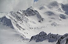
138:(3.768 m, right upper corner). In the diagram top right, the saddle is comparable to the leftmost drawn type.
442:
331:
178:
1111:
1080:
400:
742:
747:
523:
1011:
513:
447:
110:
in the perpendicular axis, simultaneously; that point being by definition the col of the saddle.
195:
1024:
828:
717:
587:
567:
467:
437:
245:
40:
1001:
885:
602:
557:
8:
1034:
910:
895:
872:
868:
647:
572:
472:
457:
198:, an important measure of the independence of its summit. Saddles lie on the line of the
181:
implies that a col is the lowest point on the saddle. Monkhouse describes a saddle as a
1101:
983:
880:
762:
667:
582:
547:
477:
423:
217:
49:
the distance from a prominence which is also a minimum to the point of the same height
1019:
953:
905:
900:
780:
770:
487:
336:
313:
107:
103:
244:
derives its name from the fact that the prototypical example in two dimensions is a
1106:
823:
818:
752:
727:
722:
697:
637:
597:
452:
187:
The term col tends to be associated more with mountain, rather than hill, ranges.
1062:
958:
858:
833:
805:
790:
692:
642:
632:
627:
503:
199:
148:
963:
940:
925:
795:
775:
687:
612:
607:
562:
528:
518:
462:
131:
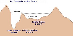
57:) of the right two peaks is not labeled, but is represented by the dashed line.
577:
1095:
853:
261:
95:
848:
508:
482:
235:
87:
1029:
915:
890:
843:
838:
813:
702:
622:
592:
285:
241:
1057:
1044:
552:
191:
143:
135:
30:
662:
993:
973:
968:
948:
930:
920:
732:
677:
539:
392:
221:
1052:
978:
375:
23:
Cross-section diagram of three hills, with two saddles marked by X.
335:, 2nd Ed., revised, Oxford University Press, Oxford, New York, p.
785:
737:
682:
127:
90:, the lowest point on the line tracing the drainage divide (the
652:
617:
257:
220:, a saddle is a depression located along the axial trend of an
99:
74:
672:
86:
between two hills or mountains is the region surrounding the
19:
190:
The height of a summit above its highest saddle (called the
707:
203:
183:"broad, flat col in a ridge between two mountain summits."
170:
91:
329:
Soanes, Catherine and
Stevenson, Angus (ed.) (2005).
142:
A saddle is the lowest area between two highlands (
175:"low point or col on a ridge between two summits"
1093:
39: • The diagram illustrates the
256:in a different direction, resembling a riding
408:
264:between two peaks forming a landform saddle.
126:(lower edge, left from middle) in Tyrolia in
53: • The 'isolation' (German:
59: • "sattel zwischen" means
415:
401:
365:Chambers 21st Century Dictionary, Allied.
25: • There are three peaks (
154:
117:
73:
18:
229:
194:) is effectively a measure of a hill's
63:, so the labeling is saying the saddle
1094:
422:
396:
211:
169:The relationship between saddles and
658:List of tectonic plate interactions
164:
13:
14:
1123:
312:. London: Penguin, 1984, p. 464.
1076:
1075:
376:"Glossary of Structural Geology"
310:Dictionary of Physical Geography
16:Land connecting two high points
368:
359:
346:
323:
302:
274:
130:. It is frequently crossed by
1:
295:
113:
332:Oxford Dictionary of English
179:Oxford Dictionary of English
7:
10:
1128:
233:
1071:
1043:
1010:
992:
939:
867:
804:
761:
743:Thick-skinned deformation
537:
496:
430:
354:A Dictionary of Geography
748:Thin-skinned deformation
524:Stereographic projection
267:
514:Orthographic projection
497:Measurement conventions
443:Lamé's stress ellipsoid
352:Monkhouse, FJ (1965).
308:Whittow, John (1984).
252:in one direction, and
161:
139:
106:along one axis, and a
79:
71:
67:is the same saddle as
1025:Paleostress inversion
718:Strike-slip tectonics
588:Extensional tectonics
568:Continental collision
438:Deformation mechanism
280:See the center image
158:
134:on the way up to the
121:
77:
41:topographic isolation
22:
603:Fold and thrust belt
240:A 'saddle point' in
230:Mathematical saddles
78:Route along a saddle
1035:Section restoration
911:Rock microstructure
573:Convergent boundary
473:Strain partitioning
458:Overburden pressure
448:Mohr–Coulomb theory
35:'A', 'B', & 'C'
1112:Structural geology
1012:Kinematic analysis
668:Mountain formation
583:Divergent boundary
548:Accretionary wedge
424:Structural geology
218:structural geology
212:Structural geology
162:
140:
80:
72:
1089:
1088:
1020:3D fold evolution
906:Pressure solution
901:Oblique foliation
781:Exfoliation joint
771:Columnar jointing
431:Underlying theory
341:978-0-19-861057-1
1119:
1079:
1078:
824:Detachment fault
819:Cataclastic rock
753:Thrust tectonics
723:Structural basin
698:Pull-apart basin
638:Horst and graben
417:
410:
403:
394:
393:
387:
386:
384:
382:
372:
366:
363:
357:
350:
344:
327:
321:
306:
289:
278:
165:Saddles and cols
98:between the two
1127:
1126:
1122:
1121:
1120:
1118:
1117:
1116:
1092:
1091:
1090:
1085:
1067:
1039:
1006:
988:
959:Detachment fold
935:
863:
859:Transform fault
834:Fault mechanics
800:
757:
693:Plate tectonics
643:Intra-arc basin
533:
504:Brunton compass
492:
426:
421:
391:
390:
380:
378:
374:
373:
369:
364:
360:
351:
347:
328:
324:
307:
303:
298:
293:
292:
279:
275:
270:
238:
232:
214:
167:
149:drainage divide
116:
69:between A and B
65:between A and C
58:
52:
38:
24:
17:
12:
11:
5:
1125:
1115:
1114:
1109:
1104:
1087:
1086:
1084:
1083:
1072:
1069:
1068:
1066:
1065:
1060:
1055:
1049:
1047:
1041:
1040:
1038:
1037:
1032:
1027:
1022:
1016:
1014:
1008:
1007:
1005:
1004:
998:
996:
990:
989:
987:
986:
981:
976:
971:
966:
961:
956:
951:
945:
943:
937:
936:
934:
933:
928:
926:Tectonic phase
923:
918:
913:
908:
903:
898:
893:
888:
883:
877:
875:
865:
864:
862:
861:
856:
851:
846:
841:
836:
831:
826:
821:
816:
810:
808:
802:
801:
799:
798:
793:
788:
783:
778:
773:
767:
765:
759:
758:
756:
755:
750:
745:
740:
735:
730:
725:
720:
715:
710:
705:
700:
695:
690:
688:Passive margin
685:
680:
675:
670:
665:
660:
655:
650:
645:
640:
635:
630:
625:
620:
615:
613:Foreland basin
610:
608:Fold mountains
605:
600:
595:
590:
585:
580:
575:
570:
565:
563:Back-arc basin
560:
555:
550:
544:
542:
535:
534:
532:
531:
529:Strike and dip
526:
521:
516:
511:
506:
500:
498:
494:
493:
491:
490:
485:
480:
475:
470:
465:
463:Rock mechanics
460:
455:
450:
445:
440:
434:
432:
428:
427:
420:
419:
412:
405:
397:
389:
388:
367:
358:
345:
322:
300:
299:
297:
294:
291:
290:
272:
271:
269:
266:
234:Main article:
231:
228:
213:
210:
166:
163:
124:Mittelbergjoch
115:
112:
61:saddle between
15:
9:
6:
4:
3:
2:
1124:
1113:
1110:
1108:
1105:
1103:
1100:
1099:
1097:
1082:
1074:
1073:
1070:
1064:
1061:
1059:
1056:
1054:
1051:
1050:
1048:
1046:
1042:
1036:
1033:
1031:
1028:
1026:
1023:
1021:
1018:
1017:
1015:
1013:
1009:
1003:
1000:
999:
997:
995:
991:
985:
982:
980:
977:
975:
972:
970:
967:
965:
962:
960:
957:
955:
952:
950:
947:
946:
944:
942:
938:
932:
929:
927:
924:
922:
919:
917:
914:
912:
909:
907:
904:
902:
899:
897:
894:
892:
889:
887:
884:
882:
879:
878:
876:
874:
870:
866:
860:
857:
855:
854:Transfer zone
852:
850:
847:
845:
842:
840:
837:
835:
832:
830:
827:
825:
822:
820:
817:
815:
812:
811:
809:
807:
803:
797:
794:
792:
789:
787:
784:
782:
779:
777:
774:
772:
769:
768:
766:
764:
760:
754:
751:
749:
746:
744:
741:
739:
736:
734:
731:
729:
726:
724:
721:
719:
716:
714:
711:
709:
706:
704:
701:
699:
696:
694:
691:
689:
686:
684:
681:
679:
676:
674:
671:
669:
666:
664:
661:
659:
656:
654:
651:
649:
646:
644:
641:
639:
636:
634:
631:
629:
626:
624:
621:
619:
616:
614:
611:
609:
606:
604:
601:
599:
596:
594:
591:
589:
586:
584:
581:
579:
576:
574:
571:
569:
566:
564:
561:
559:
556:
554:
551:
549:
546:
545:
543:
541:
536:
530:
527:
525:
522:
520:
517:
515:
512:
510:
507:
505:
502:
501:
499:
495:
489:
486:
484:
481:
479:
476:
474:
471:
469:
466:
464:
461:
459:
456:
454:
453:Mohr's circle
451:
449:
446:
444:
441:
439:
436:
435:
433:
429:
425:
418:
413:
411:
406:
404:
399:
398:
395:
377:
371:
362:
355:
349:
342:
338:
334:
333:
326:
319:
318:0-14-051094-X
315:
311:
305:
301:
287:
286:topographical
283:
277:
273:
265:
263:
262:mountain pass
259:
255:
251:
247:
243:
237:
227:
225:
223:
219:
209:
207:
205:
201:
197:
193:
188:
185:
184:
180:
177:, whilst the
176:
172:
157:
153:
150:
145:
137:
133:
129:
125:
120:
111:
109:
105:
104:relative high
101:
97:
93:
89:
85:
76:
70:
66:
62:
56:
50:
46:
42:
36:
33:shown labeled
32:
28:
21:
849:Thrust fault
712:
538:Large-scale
509:Inclinometer
483:Stress field
379:. Retrieved
370:
361:
353:
348:
330:
325:
309:
304:
281:
276:
253:
249:
239:
236:Saddle point
226:
215:
208:
202:between two
189:
186:
182:
174:
168:
141:
132:mountaineers
123:
108:relative low
88:saddle point
83:
81:
68:
64:
60:
54:
48:
44:
34:
27:Schartenhöhe
26:
1030:Paleostress
916:Slickenside
891:Crenulation
844:Fault trace
839:Fault scarp
829:Disturbance
814:Cataclasite
703:Rift valley
623:Half-graben
593:Fault block
578:Décollement
282:point '-C-'
254:curves down
242:mathematics
144:prominences
122:The saddle
31:prominences
1096:Categories
1058:Pure shear
1045:Shear zone
1002:Competence
886:Compaction
763:Fracturing
558:Autochthon
553:Allochthon
356:, 2nd edn.
296:References
288:map image.
196:prominence
192:key saddle
136:Wildspitze
114:Topography
1102:Landforms
994:Boudinage
974:Monocline
969:Homocline
949:Anticline
931:Tectonite
921:Stylolite
896:Fissility
873:lineation
869:Foliation
733:Syneclise
678:Obduction
648:Inversion
540:tectonics
250:curves up
222:anticline
200:watershed
43:(German:
1081:Category
1053:Mylonite
984:Vergence
979:Syncline
881:Cleavage
806:Faulting
55:Dominanz
45:Dominanz
1107:Oronyms
954:Chevron
941:Folding
786:Fissure
738:Terrane
683:Orogeny
663:Mélange
598:Fenster
488:Tension
284:in the
246:surface
128:Austria
100:massifs
728:Suture
713:Saddle
653:Klippe
618:Graben
478:Stress
468:Strain
381:15 May
339:
316:
258:saddle
84:saddle
1063:Shear
791:Joint
673:Nappe
633:Horst
628:Horse
268:Notes
260:or a
248:that
204:hills
160:land.
29:) or
964:Dome
871:and
796:Vein
776:Dike
708:Rift
519:Rake
383:2016
337:ISBN
314:ISBN
171:cols
96:pass
82:The
216:In
92:col
1098::
224:.
206:.
47:)-
416:e
409:t
402:v
385:.
343:.
320:.
51:.
37:.
Text is available under the Creative Commons Attribution-ShareAlike License. Additional terms may apply.


