54:
70:
77:
216:
The park's area runs for 90 kilometres (56 mi) northwest-to-southeast along the ridge of the mountain, with a width of 30 km that takes in rivers and lakes in the adjoining valleys. Munkh
Kharirkhan's highest peak, Noyon, rises to an elevation of 4,362 meters (14,311 ft) in the
254:
The valleys and low foothills area covered with shrubs, sagebrush and other dry steppe vegetation. Higher elevations support mountain meadows with grasses such as
416:
242:). This climate is characteristic of steppe climates intermediary between desert and humid climates, and typically have precipitation is above
69:
471:
246:. At least one month averages below 0 °C (32 °F). Precipitation in the Munkhkhairkhan region averages 76 – 158 mm/year.
116:
496:
409:
364:
491:
552:
526:
402:
441:
425:
267:
446:
236:
221:. The mountain features glaciers and snowfields, with glacial activity leaving steep slopes of rock and gravel.
516:
436:
39:
521:
239:
476:
451:
466:
193:
547:
481:
456:
511:
258:. The park reports 15 square kilometers of Larch forest along the rivers in the lowest valleys.
197:
96:
53:
461:
8:
339:
486:
243:
185:
27:
231:
204:
in the Mongol-Altai
Mountains of western Mongolia, 15 km from the border with
152:
390:
Park borders, Munkhkhairkhan-Uenchiin khavtsal
National Park, ProtectedPlanet.net
218:
201:
100:
541:
501:
394:
316:
131:
118:
43:
389:
287:
156:
255:
104:
338:
Kottek, M.; Grieser, J.; Beck, C.; Rudolf, B.; Rubel, F. (2006).
196:, the second highest mountain in Mongolia. The park straddles
205:
340:"World Map of Koppen-Geiger Climate Classification Updated"
175:
Ministry of
Environment and Green Development of Mongolia
337:
76:
539:
424:
410:
417:
403:
365:"Dataset - Koppen climate classifications"
311:
309:
307:
305:
224:
357:
302:
280:
540:
398:
319:(in Mongolian). Official park website
13:
331:
268:List of national parks of Mongolia
249:
14:
564:
383:
75:
68:
52:
317:"Munkhkhairkhan National Park"
1:
273:
237:Köppen climate classification
211:
497:Khorgo-Terkhiin Tsagaan Nuur
182:Munkhkhairkhan National Park
22:Munkhkhairkhan National Park
7:
345:. Gebrüder Borntraeger 2006
261:
229:The climate of the area is
10:
569:
553:National parks of Mongolia
426:National parks of Mongolia
217:Mongol-Altai Range of the
432:
189:
171:
163:
147:
110:
92:
63:
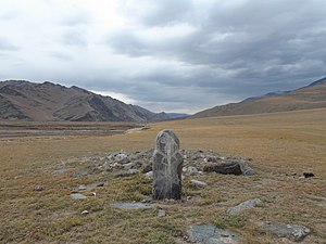
58:Balbal at Munkh-Khairkhan
51:
37:
31:
26:
21:
16:National park in Mongolia
194:Mönkhkhairkhan Mountain
232:Cold semi-arid climate
527:Ulaagchinii Khar Nuur
225:Climate and ecoregion
442:Bulgan Gol-Ikh Ongog
198:Bayan-Ölgii Province
97:Bayan-Ölgii Province
172:Governing body
128: /
447:Gobi Gurvansaikhan
290:. Protected Planet
244:evapotranspiration
535:
534:
288:"Munkh-Khairkhan"
192:) is centered on
179:
178:
153:square kilometres
560:
548:IUCN Category II
517:Tarvagatai Nuruu
437:Altai Tavan Bogd
419:
412:
405:
396:
395:
377:
376:
374:
372:
361:
355:
354:
352:
350:
344:
335:
329:
328:
326:
324:
313:
300:
299:
297:
295:
284:
191:
143:
142:
140:
139:
138:
133:
129:
126:
125:
124:
121:
84:Location of Park
79:
78:
72:
56:
33:
19:
18:
568:
567:
563:
562:
561:
559:
558:
557:
538:
537:
536:
531:
522:Tsambagarav Uul
428:
423:
386:
381:
380:
370:
368:
363:
362:
358:
348:
346:
342:
336:
332:
322:
320:
315:
314:
303:
293:
291:
286:
285:
281:
276:
264:
252:
250:Flora and fauna
227:
219:Altai Mountains
214:
136:
134:
130:
127:
122:
119:
117:
115:
114:
88:
87:
86:
85:
82:
81:
80:
59:
47:
17:
12:
11:
5:
566:
556:
555:
550:
533:
532:
530:
529:
524:
519:
514:
509:
507:Munkhkhairkhan
504:
499:
494:
489:
484:
479:
474:
469:
464:
459:
454:
449:
444:
439:
433:
430:
429:
422:
421:
414:
407:
399:
393:
392:
385:
384:External links
382:
379:
378:
356:
330:
301:
278:
277:
275:
272:
271:
270:
263:
260:
251:
248:
226:
223:
213:
210:
202:Khovd Province
177:
176:
173:
169:
168:
165:
161:
160:
149:
145:
144:
112:
108:
107:
101:Khovd Province
94:
90:
89:
83:
74:
73:
67:
66:
65:
64:
61:
60:
57:
49:
48:
38:
35:
34:
24:
23:
15:
9:
6:
4:
3:
2:
565:
554:
551:
549:
546:
545:
543:
528:
525:
523:
520:
518:
515:
513:
510:
508:
505:
503:
502:Khyargas Nuur
500:
498:
495:
493:
490:
488:
487:Lake Khövsgöl
485:
483:
480:
478:
477:Khangai Nuruu
475:
473:
470:
468:
465:
463:
460:
458:
455:
453:
452:Gorkhi-Terelj
450:
448:
445:
443:
440:
438:
435:
434:
431:
427:
420:
415:
413:
408:
406:
401:
400:
397:
391:
388:
387:
371:September 14,
366:
360:
349:September 14,
341:
334:
318:
312:
310:
308:
306:
289:
283:
279:
269:
266:
265:
259:
257:
247:
245:
241:
238:
234:
233:
222:
220:
209:
207:
203:
199:
195:
187:
183:
174:
170:
166:
162:
158:
154:
150:
146:
141:
113:
109:
106:
102:
98:
95:
91:
71:
62:
55:
50:
45:
44:national park
41:
40:IUCN category
36:
29:
25:
20:
506:
492:Khan Khentii
467:Khar-Us Nuur
369:. Retrieved
367:. World Bank
359:
347:. Retrieved
333:
321:. Retrieved
292:. Retrieved
282:
253:
230:
228:
215:
181:
180:
155:(1,954
482:Khogno Khan
472:Khan-Khokhi
190:Мөнххайрхан
164:Established
135: /
132:47°N 92.5°E
111:Coordinates
32:Мөнххайрхан
542:Categories
457:Gun-Galuut
274:References
212:Topography
157:sq mi
512:Onon-Balj
323:April 18,
294:April 11,
186:Mongolian
28:Mongolian
262:See also
256:Koeleria
137:47; 92.5
105:Mongolia
93:Location
123:92°30′E
120:47°00′N
462:Hustai
151:5,061
343:(PDF)
240:(BSk)
206:China
373:2019
351:2019
325:2020
296:2020
200:and
167:2011
148:Area
99:and
42:II (
208:.
544::
304:^
188::
103:,
30::
418:e
411:t
404:v
375:.
353:.
327:.
298:.
235:(
184:(
159:)
46:)
Text is available under the Creative Commons Attribution-ShareAlike License. Additional terms may apply.

