236:
1055:
22:
1196:
221:
679:
318:
669:
206:
1009:
1067:
610:, which mean 'old woman' and 'peak' or 'summit', respectively. The legend goes that two groups of people were each living on the summit of a hill, one of them named Sau Raha (now Soraha) and the other Sau Lor (now Saulidun). The two groups were engaged separately in their own daily activities, but each was accompanied by one of two
66:, is a useful starting point for translations, but translators must revise errors as necessary and confirm that the translation is accurate, rather than simply copy-pasting machine-translated text into the English Knowledge.
928:
699:
354:
52:
517:
884:
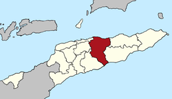
564:, located in the central part of the country. It has a population of 45,541 (Census 2010) and an area of 1,783.3 km. The capital of the municipality is also named
446:
1099:
469:
428:
69:
Do not translate text that appears unreliable or low-quality. If possible, verify the text with references provided in the foreign-language article.
982:
935:
1034:
958:
278:
405:
1092:
649:
to the west. It reaches both the south and north coasts of the island, and is only one of two municipalities to do so (the other is
1013:
1220:
1085:
822:
771:, later to become the nation's first president. He was born in the village of Laleia (19 km East of Manatuto town).
343:
134:
77:
907:
90:
Content in this edit is translated from the existing German
Knowledge article at ]; see its history for attribution.
1215:
1108:
723:
711:
569:
557:
374:
364:
158:
138:
126:
729:
974:
1045:
753:
717:
369:
220:
99:
1164:
705:
359:
310:
85:
505:
1195:
1144:
34:
1159:
650:
1185:
1174:
1139:
638:
634:
106:
205:
957:[Manatuto Municipality: Municipal Strategic Development Plan] (Report) (in Tetum).
8:
1154:
1134:
1124:
749:
630:
541:
379:
330:
177:
954:
1119:
642:
485:
235:
1149:
903:
646:
622:
The borders of the municipality of
Manatuto are identical to those of the council of
81:
1071:
1029:
623:
768:
1054:
833:
654:
588:
1077:
793:
745:
653:
in the far east), and has the most geographical diversity. To the north is the
585:
549:
192:
1209:
830:
Placenames
Australia: Newsletter of the Australian National Placenames Survey
818:
498:
293:
280:
736:
The administrative posts are divided into 29 sucos ("villages") in total.
1059:
599:
678:
561:
481:
323:
257:
88:
to the source of your translation. A model attribution edit summary is
934:(Report). District Administrator, Manatuto. April 2002. Archived from
695:
The municipality's administrative posts (formerly sub-districts) are:
658:
476:
759:, which is designated as a "national language" by the constitution.
565:
493:
335:
130:
1179:
752:), a large part of the population of the municipality speaks the
668:
63:
1129:
1008:
955:
Munisipio
Manatuto: Planu Estartejiku Desenvolvimentu Munisipal
756:
611:
1021:
584:
has been said to be a
Portuguese approximation of the local
858:
528:
1025:– official site (in Tetum with some content in English)
1043:
744:
In addition to the official languages of East Timor (
794:"Sub-national HDI - Area Database - Global Data Lab"
59:
55:
a machine-translated version of the German article.
902:. Lanham, Maryland: Scarecrow Press. p. 124.
1207:
1107:
169:
961:/ Administration of Manatuto Municipality. 2015
767:The municipality is known as the birthplace of
629:The municipality borders the municipalities of
84:accompanying your translation by providing an
46:Click for important translation instructions.
33:expand this article with text translated from
1093:
959:Ministry of State Administration (East Timor)
786:
598:According to another source, the word is a
184:
1100:
1086:
851:
811:
677:
667:
690:
397:1,783.3 km (688.5 sq mi)
1208:
1081:
96:{{Translated|de|Manatuto (Gemeinde)}}
977:[Manatuto District Profile]
817:
15:
900:Historical Dictionary of East Timor
13:
887:. Timor-Leste Ministry of Finance.
14:
1232:
1002:
988:from the original on 3 March 2014
762:
1194:
1065:
1053:
1035:Ministry of State Administration
1007:
897:
861:[Profile: 2. Toponymy].
672:Administrative posts of Manatuto
316:
234:
219:
204:
20:
920:
739:
595:, which means 'pecking birds'.
891:
877:
823:"The placenames of East Timor"
94:You may also add the template
1:
774:
1221:Municipalities of East Timor
1109:Municipalities of East Timor
617:
575:
568:. It is the least populated
139:Manatuto Administrative Post
7:
981:(Report) (in Tetum). 2012.
10:
1237:
754:Malayo-Polynesian language
159:Municipality of East Timor
144:Municipality of East Timor
125:This article is about the
124:
120:Municipality of East Timor
58:Machine translation, like
1192:
1115:
1039:(in Portuguese and Tetum)
929:Manatuto District Profile
898:Gunn, Geoffrey C (2011).
523:
504:
492:
475:
465:
457:
452:
442:
434:
424:
416:
411:
401:
393:
388:
341:
329:
309:
274:
265:
233:
215:
203:
165:
156:
149:
35:the corresponding article
975:Perfil Distritu Manatuto
779:
560:(formerly districts) of
453:Households (2015 census)
1014:Manatuto (Municipality)
885:"Manatuto Suco Reports"
553:
443: • Rank
185:
105:For more guidance, see
1033:– information page on
859:"Perfil: 2. Toponímia"
683:
673:
657:, to the south is the
545:
170:
1216:Manatuto Municipality
1030:Manatuto Municipality
1022:Manatuto Municipality
1016:at Wikimedia Commons
863:Manatuto Municipality
832:: 6–7. Archived from
798:hdi.globaldatalab.org
681:
671:
614:, who were brothers.
529:Manatuto Municipality
438:26/km (68/sq mi)
107:Knowledge:Translation
78:copyright attribution
691:Administrative posts
626:with the same name.
435: • Density
344:Administrative posts
129:. For the city, see
839:on 14 February 2017
602:of the Tetum words
290: /
135:administrative post
684:
682:Cities of Manatuto
674:
554:Munisípiu Manatutu
546:Município Manatuto
458: • Total
417: • Total
394: • Total
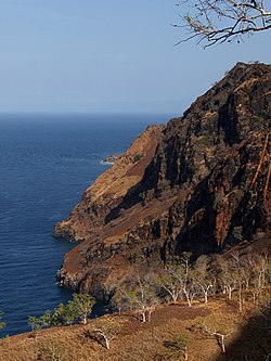
210:Cliffs at Manatuto
186:Munisípiu Manatutu
171:Município Manatuto
86:interlanguage link
1203:
1202:
1012:Media related to
700:Barique-Natarbora
688:
687:
535:
534:
466: • Rank
425: • Rank
402: • Rank
355:Barique-Natarbora
294:8.700°S 125.917°E
118:
117:
47:
43:
1228:
1198:
1102:
1095:
1088:
1079:
1078:
1070:
1069:
1068:
1058:
1057:
1049:
1040:
1032:
1024:
1011:
997:
995:
993:
987:
980:
970:
968:
966:
950:
948:
946:
941:on 28 March 2009
940:
933:
914:
913:
895:
889:
888:
881:
875:
874:
872:
870:
855:
849:
848:
846:
844:
838:
827:
815:
809:
808:
806:
804:
790:
664:
663:
637:to the east and
624:Portuguese Timor
556:) is one of the
531:
515:
346:
322:
320:
319:
305:
304:
302:
301:
300:
295:
291:
288:
287:
286:
283:
255:
253:
245:
243:
238:
223:
208:
196:
188:
181:
173:
147:
146:
97:
91:
64:Google Translate
45:
41:
24:
23:
16:
1236:
1235:
1231:
1230:
1229:
1227:
1226:
1225:
1206:
1205:
1204:
1199:
1190:
1111:
1106:
1076:
1066:
1064:
1052:
1044:
1038:
1028:
1020:
1005:
1000:
991:
989:
985:
978:
973:
964:
962:
953:
944:
942:
938:
931:
927:
923:
918:
917:
910:
896:
892:
883:
882:
878:
868:
866:
857:
856:
852:
842:
840:
836:
825:
816:
812:
802:
800:
792:
791:
787:
782:
777:
765:
742:
693:
655:Strait of Wetar
620:
589:Galoli language
578:
572:of East Timor.
527:
513:
512:
384:
342:
317:
315:
299:-8.700; 125.917
298:
296:
292:
289:
284:
281:
279:
277:
276:
270:
269:
261:
251:
250:
241:
240:
229:
228:
227:
226:
211:
199:
190:
175:
161:
152:
145:
142:
121:
114:
113:
112:
95:
89:
48:
25:
21:
12:
11:
5:
1234:
1224:
1223:
1218:
1201:
1200:
1193:
1191:
1189:
1188:
1183:
1177:
1172:
1167:
1162:
1157:
1152:
1147:
1142:
1137:
1132:
1127:
1122:
1116:
1113:
1112:
1105:
1104:
1097:
1090:
1082:
1075:
1074:
1062:
1042:
1041:
1026:
1004:
1003:External links
1001:
999:
998:
971:
951:
924:
922:
919:
916:
915:
908:
890:
876:
850:
819:Hull, Geoffrey
810:
784:
783:
781:
778:
776:
773:
764:
763:Notable people
761:
741:
738:
734:
733:
727:
721:
715:
709:
703:
692:
689:
686:
685:
675:
619:
616:
577:
574:
558:municipalities
533:
532:
525:
521:
520:
509:
502:
501:
496:
490:
489:
479:
473:
472:
467:
463:
462:
459:
455:
454:
450:
449:
444:
440:
439:
436:
432:
431:
426:
422:
421:
418:
414:
413:
409:
408:
403:
399:
398:
395:
391:
390:
386:
385:
383:
382:
377:
372:
367:
362:
357:
351:
347:
339:
338:
333:
327:
326:
313:
307:
306:
272:
271:
267:
266:
263:
262:
239:
231:
230:
224:
218:
217:
216:
213:
212:
209:
201:
200:
198:
197:
182:
166:
163:
162:
157:
154:
153:
150:
143:
119:
116:
115:
111:
110:
103:
92:
70:
67:
56:
49:
30:
29:
28:
26:
19:
9:
6:
4:
3:
2:
1233:
1222:
1219:
1217:
1214:
1213:
1211:
1197:
1187:
1184:
1181:
1178:
1176:
1173:
1171:
1168:
1166:
1163:
1161:
1158:
1156:
1153:
1151:
1148:
1146:
1143:
1141:
1138:
1136:
1133:
1131:
1128:
1126:
1123:
1121:
1118:
1117:
1114:
1110:
1103:
1098:
1096:
1091:
1089:
1084:
1083:
1080:
1073:
1063:
1061:
1056:
1051:
1050:
1047:
1036:
1031:
1027:
1023:
1019:
1018:
1017:
1015:
1010:
984:
976:
972:
960:
956:
952:
937:
930:
926:
925:
911:
909:9780810867543
905:
901:
894:
886:
880:
864:
860:
854:
835:
831:
824:
821:(June 2006).
820:
814:
799:
795:
789:
785:
772:
770:
769:Xanana Gusmão
760:
758:
755:
751:
747:
737:
731:
728:
726:(pop. 11,500)
725:
722:
719:
716:
714:(pop. 10,100)
713:
710:
707:
704:
701:
698:
697:
696:
680:
676:
670:
666:
665:
662:
660:
656:
652:
648:
644:
640:
636:
632:
627:
625:
615:
613:
609:
605:
601:
596:
594:
590:
587:
583:
573:
571:
567:
563:
559:
555:
551:
547:
543:
539:
530:
526:
522:
519:
510:
507:
503:
500:
497:
495:
494:ISO 3166 code
491:
487:
483:
480:
478:
474:
471:
468:
464:
460:
456:
451:
448:
445:
441:
437:
433:
430:
427:
423:
419:
415:
410:
407:
404:
400:
396:
392:
387:
381:
378:
376:
373:
371:
368:
366:
363:
361:
358:
356:
353:
352:
350:
348:
345:
340:
337:
334:
332:
328:
325:
314:
312:
308:
303:
275:Coordinates:
273:
268:OpenStreetMap
264:
260:
259:
248:
237:
232:
222:
214:
207:
202:
194:
187:
183:
179:
172:
168:
167:
164:
160:
155:
148:
140:
136:
132:
128:
123:
108:
104:
101:
93:
87:
83:
79:
75:
71:
68:
65:
61:
57:
54:
51:
50:
44:
38:
36:
31:You can help
27:
18:
17:
1169:
1006:
990:. Retrieved
963:. Retrieved
943:. Retrieved
936:the original
921:Bibliography
899:
893:
879:
867:. Retrieved
862:
853:
841:. Retrieved
834:the original
829:
813:
803:13 September
801:. Retrieved
797:
788:
766:
743:
740:Demographics
735:
732:(pop. 2,950)
720:(pop. 3,200)
708:(pop. 6,400)
702:(pop. 4,900)
694:
628:
621:
607:
603:
597:
592:
581:
579:
570:municipality
537:
536:
349:
256:
246:
225:Official map
127:municipality
122:
82:edit summary
73:
40:
32:
945:27 February
600:portmanteau
297: /
42:(July 2011)
1210:Categories
865:(in Tetum)
775:References
750:Portuguese
562:East Timor
542:Portuguese
412:Population
324:East Timor
258:East Timor
178:Portuguese
133:. For the
1145:Cova Lima
1072:Geography
659:Timor Sea
618:Geography
586:Tetum and
580:The word
576:Etymology
482:UTC+09:00
477:Time zone
249:in
247:Manatuto
100:talk page
37:in German
1186:Viqueque
1175:Manufahi
1170:Manatuto
1140:Bobonaro
983:Archived
724:Manatuto
712:Laclubar
639:Manufahi
635:Viqueque
593:Manatutu
582:Manatuto
566:Manatuto
538:Manatuto
375:Manatuto
365:Laclubar
336:Manatuto
285:125°55′E
151:Manatuto
131:Manatuto
76:provide
1180:Oecusse
1165:Liquiçá
1046:Portals
992:18 July
965:18 July
869:18 July
730:Soibada
524:Website
380:Soibada
331:Capital
311:Country
98:to the
80:in the
39:.
1160:Lautém
1155:Ermera
1135:Baucau
1130:Atauro
1125:Ainaro
906:
843:4 June
757:Galoli
718:Laleia
651:Lautém
645:, and
631:Baucau
612:Liurai
514:medium
508:(2017)
420:46,619
370:Laleia
321:
282:8°42′S
254:
252:
244:
242:
189:
174:
137:, see
1182:(SAR)
1120:Aileu
1037:site
986:(PDF)
979:(PDF)
939:(PDF)
932:(PDF)
837:(PDF)
826:(PDF)
780:Notes
746:Tetum
706:Laclo
643:Aileu
591:word
550:Tetum
511:0.614
499:TL-MT
461:7,467
360:Laclo
193:Tetum
60:DeepL
1150:Dili
1060:Asia
994:2022
967:2022
947:2022
904:ISBN
871:2022
845:2018
805:2018
748:and
647:Dili
633:and
608:tutu
606:and
604:Mana
470:12th
447:13th
429:13th
389:Area
74:must
72:You
53:View
518:5th
506:HDI
486:TLT
406:2nd
62:or
1212::
828:.
796:.
661:.
641:,
552::
548:,
544::
516:·
1101:e
1094:t
1087:v
1048::
996:.
969:.
949:.
912:.
873:.
847:.
807:.
540:(
488:)
484:(
195:)
191:(
180:)
176:(
141:.
109:.
102:.
Text is available under the Creative Commons Attribution-ShareAlike License. Additional terms may apply.


