125:
70:
179:
98:
45:
60:
618:
856:
873:
848:
826:
748:
105:
1034:
404:
which fused in 1971. In 2021, Kluisbergen had a total population of 6,682. The total area is 30.38 km². The town of Ruien is the largest and has some outdoor facilities. Kluisbergen is also home to the "Kluisbos", a forest which has 2 ancient standing stones, dating back to Roman times.
634:
makes up the northwestern border of
Kluisbergen where the landscape is rather flat. Traveling south or southeast is met with an increasing moderately hilly landscape all the way to the southern border
696:
672:
are known for their steep hills with several of them having forests on their hillsides. Kluisbergen is no exception and is best known for these hills. Their important role in the
422:
929:
368:
432:
203:
191:
524:
676:
make them popular among cyclists. The municipality incorporates its many field trails in hiking routes with hiking tours are also being organized.
788:
922:
599:
718:
646:
539:
638:
1422:
584:
479:
452:
394:
1417:
915:
569:
1391:
383:
141:
781:
227:
907:
621:
Map of
Kluisbergen with its neighbouring towns/municipalities. The yellow markings resemble the most populated areas.
69:
97:
44:
1323:
1042:
774:
1254:
752:
373:
318:
232:
938:
352:
35:
59:
1152:
1107:
962:
294:
679:
Kwaremont has the title of "Artist
Village" because of its numerous painters and art galleries.
1382:
641:
is mainly located on the border of Ruien and Orroir, stretching all the way to
Kwaremont. The
1412:
942:
215:
388:
8:
1016:
884:
603:
588:
573:
124:
1234:
888:
937:
1224:
196:
689:
1348:
1308:
810:
673:
669:
658:
513:
1262:
766:
1209:
1067:
988:
971:
950:
347:
208:
1406:
1219:
1137:
1004:
946:
839:
654:
360:
220:
156:
143:
1354:
1177:
1082:
1061:
977:
1293:
1239:
1229:
1055:
815:
498:
399:
1287:
1214:
1204:
982:
862:
642:
483:
442:
379:
1336:
1267:
1199:
1172:
1132:
1127:
1115:
1092:
1087:
1022:
994:
306:
1360:
1342:
1331:
1277:
1182:
1142:
1077:
1050:
999:
954:
835:
631:
617:
558:
554:
543:
528:
509:
364:
356:
184:
1282:
1187:
1166:
1160:
1072:
1010:
747:
494:
1365:
1313:
1301:
1244:
1193:
1121:
894:
650:
469:
331:
1033:
758:
1097:
697:"Wettelijke Bevolking per gemeente op 1 januari 2018"
16:
Municipality in the
Belgian province of East Flanders
657:. The three hills are the westernmost hills of the
796:
719:"Bevolking per statistische sector - Sector 45060"
1404:
637:There are three main hills in Kluisbergen. The
367:river. The municipality comprises the towns of
923:
782:
645:is located in the middle of Kwaremont. The
930:
916:
789:
775:
21:Municipality in Flemish Community, Belgium
649:is located on the border of Zulzeke and
616:
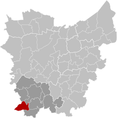
120:Location of Kluisbergen in East Flanders
1405:
1392:municipality with language facilities
911:
770:
346:
268:30.63 km (11.83 sq mi)
252: • Governing party/ies
804:
413:Kluisbergen consists of four towns:
711:
460:Neighbouring towns/municipalities:
104:
13:
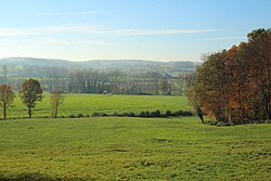
49:Typical Flemish Ardennes landscape
14:
1434:
1423:Populated places in East Flanders
740:
1032:
871:
854:
846:
824:
746:
177:
123:
103:
96:
68:
58:
43:
1418:Municipalities of East Flanders
797:Places adjacent to Kluisbergen
1:
872:
825:
682:
855:
847:
653:and is the highest point of
625:
408:
7:
447:
437:
427:
417:
10:
1439:
664:
451:
441:
431:
421:
1374:
1322:
1253:
1151:
1106:
1041:
1030:
961:
802:
348:[ˈklœyzˌbɛrɣə(n)]
327:
317:
305:
293:
285:
277:
272:
264:
259:
251:
243:
238:
226:
214:
202:
190:
172:
137:
91:
82:
54:
42:
33:
26:
289:210/km (550/sq mi)
85:Location of Kluisbergen
622:
612:
620:
755:at Wikimedia Commons
344:Dutch pronunciation:
286: • Density
117:Location in Belgium
1017:Sint-Lievens-Houtem
153: /
1235:Sint-Martens-Latem
723:Statistics Belgium
623:
332:www.kluisbergen.be
278: • Total
265: • Total
247:Philippe Willequet
244: • Mayor
1400:
1399:
905:
904:
900:
899:
751:Media related to
610:
609:
458:
457:
337:
336:
197:Flemish Community
1430:
1349:Sint-Gillis-Waas
1309:Wortegem-Petegem
1036:
932:
925:
918:
909:
908:
885:Mont-de-l'Enclus
875:
874:
858:
857:
850:
849:
828:
827:
811:Wortegem-Petegem
805:
791:
784:
777:
768:
767:
763:
759:Official website
750:
734:
733:
731:
729:
715:
709:
708:
706:
704:
693:
674:Tour of Flanders
670:Flemish Ardennes
659:Flemish Ardennes
604:Mont-de-l'Enclus
589:Mont-de-l'Enclus
574:Mont-de-l'Enclus
514:Wortegem-Petegem
463:
462:
416:
415:
403:
392:
377:
350:
345:
255:Gemeentebelangen
183:
181:
180:
168:
167:
165:
164:
163:
158:
157:50.783°N 3.517°E
154:
151:
150:
149:
146:
127:
107:
106:
100:
72:
62:
47:
24:
23:
1438:
1437:
1433:
1432:
1431:
1429:
1428:
1427:
1403:
1402:
1401:
1396:
1370:
1318:
1249:
1147:
1102:
1037:
1028:
957:
936:
906:
901:
859:
798:
795:
761:
743:
738:
737:
727:
725:
717:
716:
712:
702:
700:
695:
694:
690:
685:
667:
628:
615:
411:
397:
386:
371:
355:located in the
343:
313:
301:
178:
176:
161:
159:
155:
152:
147:
144:
142:
140:
139:
133:
132:
131:
130:
129:
128:
121:
115:
114:
113:
112:
108:
87:
86:
78:
77:
76:
75:
66:
65:
50:
38:
29:
22:
17:
12:
11:
5:
1436:
1426:
1425:
1420:
1415:
1398:
1397:
1395:
1394:
1385:
1375:
1372:
1371:
1369:
1368:
1363:
1358:
1351:
1346:
1339:
1334:
1328:
1326:
1320:
1319:
1317:
1316:
1311:
1306:
1297:
1290:
1285:
1280:
1275:
1270:
1265:
1259:
1257:
1251:
1250:
1248:
1247:
1242:
1237:
1232:
1227:
1222:
1217:
1212:
1207:
1202:
1197:
1190:
1185:
1180:
1175:
1170:
1163:
1157:
1155:
1149:
1148:
1146:
1145:
1140:
1135:
1130:
1125:
1118:
1112:
1110:
1104:
1103:
1101:
1100:
1095:
1090:
1085:
1080:
1075:
1070:
1065:
1058:
1053:
1047:
1045:
1039:
1038:
1031:
1029:
1027:
1026:
1019:
1014:
1007:
1002:
997:
992:
989:Geraardsbergen
985:
980:
975:
967:
965:
959:
958:
939:Municipalities
935:
934:
927:
920:
912:
903:
902:
898:
897:
892:
882:
879:
878:
876:
869:
866:
865:
860:
845:
843:
832:
831:
829:
822:
819:
818:
813:
808:
803:
800:
799:
794:
793:
786:
779:
771:
765:
764:
756:
742:
741:External links
739:
736:
735:
710:
687:
686:
684:
681:
666:
663:
627:
624:
614:
611:
608:
607:
597:
593:
592:
582:
578:
577:
567:
563:
562:
552:
548:
547:
537:
533:
532:
522:
518:
517:
507:
503:
502:
492:
488:
487:
477:
473:
472:
467:
456:
455:
450:
446:
445:
440:
436:
435:
430:
426:
425:
420:
410:
407:
335:
334:
329:
325:
324:
321:
315:
314:
311:
309:
303:
302:
299:
297:
291:
290:
287:
283:
282:
279:
275:
274:
270:
269:
266:
262:
261:
257:
256:
253:
249:
248:
245:
241:
240:
236:
235:
230:
228:Arrondissement
224:
223:
218:
212:
211:
209:Flemish Region
206:
200:
199:
194:
188:
187:
174:
170:
169:
135:
134:
122:
119:
118:
116:
110:
109:
102:
101:
95:
94:
93:
92:
89:
88:
84:
83:
80:
79:
73:
67:
63:
57:
56:
55:
52:
51:
48:
40:
39:
34:
31:
30:
27:
20:
15:
9:
6:
4:
3:
2:
1435:
1424:
1421:
1419:
1416:
1414:
1411:
1410:
1408:
1393:
1389:
1386:
1384:
1380:
1377:
1376:
1373:
1367:
1364:
1362:
1359:
1357:
1356:
1352:
1350:
1347:
1345:
1344:
1340:
1338:
1335:
1333:
1330:
1329:
1327:
1325:
1321:
1315:
1312:
1310:
1307:
1305:
1304:
1303:
1298:
1296:
1295:
1291:
1289:
1286:
1284:
1281:
1279:
1276:
1274:
1271:
1269:
1266:
1264:
1261:
1260:
1258:
1256:
1252:
1246:
1243:
1241:
1238:
1236:
1233:
1231:
1228:
1226:
1223:
1221:
1220:Moerbeke-Waas
1218:
1216:
1213:
1211:
1208:
1206:
1203:
1201:
1198:
1196:
1195:
1191:
1189:
1186:
1184:
1181:
1179:
1176:
1174:
1171:
1169:
1168:
1164:
1162:
1159:
1158:
1156:
1154:
1150:
1144:
1141:
1139:
1138:Sint-Laureins
1136:
1134:
1131:
1129:
1126:
1124:
1123:
1119:
1117:
1114:
1113:
1111:
1109:
1105:
1099:
1096:
1094:
1091:
1089:
1086:
1084:
1081:
1079:
1076:
1074:
1071:
1069:
1066:
1064:
1063:
1059:
1057:
1054:
1052:
1049:
1048:
1046:
1044:
1040:
1035:
1025:
1024:
1020:
1018:
1015:
1013:
1012:
1008:
1006:
1003:
1001:
998:
996:
993:
991:
990:
986:
984:
981:
979:
976:
974:
973:
969:
968:
966:
964:
960:
956:
952:
948:
947:East Flanders
944:
940:
933:
928:
926:
921:
919:
914:
913:
910:
896:
893:
890:
886:
883:
881:
880:
877:
870:
868:
867:
864:
861:
853:
844:
841:
837:
834:
833:
830:
823:
821:
820:
817:
814:
812:
809:
807:
806:
801:
792:
787:
785:
780:
778:
773:
772:
769:
760:
757:
754:
749:
745:
744:
724:
720:
714:
698:
692:
688:
680:
677:
675:
671:
662:
660:
656:
655:East Flanders
652:
648:
644:
640:
635:
633:
619:
605:
601:
598:
595:
594:
590:
586:
583:
580:
579:
575:
571:
568:
565:
564:
560:
556:
553:
550:
549:
545:
541:
538:
535:
534:
530:
526:
523:
520:
519:
515:
511:
508:
505:
504:
500:
496:
493:
490:
489:
485:
481:
478:
475:
474:
471:
468:
465:
464:
461:
454:
448:
444:
438:
434:
428:
424:
418:
414:
406:
401:
396:
390:
385:
381:
375:
370:
366:
362:
361:East Flanders
358:
354:
349:
341:
333:
330:
326:
322:
320:
316:
310:
308:
304:
298:
296:
292:
288:
284:
280:
276:
271:
267:
263:
258:
254:
250:
246:
242:
237:
234:
231:
229:
225:
222:
221:East Flanders
219:
217:
213:
210:
207:
205:
201:
198:
195:
193:
189:
186:
175:
171:
166:
162:50.783; 3.517
138:Coordinates:
136:
126:
99:
90:
81:
71:
61:
53:
46:
41:
37:
32:
25:
19:
1387:
1378:
1355:Sint-Niklaas
1353:
1341:
1324:Sint-Niklaas
1300:
1299:
1292:
1272:
1192:
1178:Destelbergen
1165:
1120:
1060:
1021:
1009:
987:
970:
851:
726:. Retrieved
722:
713:
701:. Retrieved
691:
678:
668:
636:
629:
459:
412:
363:, along the
359:province of
353:municipality
339:
338:
295:Postal codes
74:Coat of arms
36:Municipality
18:
1413:Kluisbergen
1273:Kluisbergen
1083:Waasmunster
1062:Dendermonde
1043:Dendermonde
978:Denderleeuw
852:Kluisbergen
753:Kluisbergen
600:Russeignies
398: [
387: [
372: [
340:Kluisbergen
160: /
111:Kluisbergen
28:Kluisbergen
1407:Categories
1390:indicates
1381:indicates
1294:Oudenaarde
1255:Oudenaarde
1240:Wachtebeke
1230:Oosterzele
1056:Buggenhout
816:Oudenaarde
762:(in Dutch)
683:References
647:Hotondberg
540:Waarmaarde
499:Oudenaarde
319:Area codes
273:Population
239:Government
233:Oudenaarde
1288:Maarkedal
1215:Merelbeke
1205:Lochristi
983:Erpe-Mere
863:Maarkedal
699:. Statbel
643:Paterberg
639:Kluisberg
626:Landscape
484:Maarkedal
443:Kwaremont
409:Geography
380:Kwaremont
192:Community
1337:Kruibeke
1268:Horebeke
1225:Nazareth
1200:Lievegem
1173:De Pinte
1133:Maldegem
1128:Kaprijke
1116:Assenede
1093:Wichelen
1088:Wetteren
1023:Zottegem
995:Haaltert
951:Flanders
943:Province
585:Amengies
525:Kerkhove
307:NIS code
216:Province
1361:Stekene
1343:Lokeren
1332:Beveren
1278:Kruisem
1183:Evergem
1143:Zelzate
1078:Lebbeke
1051:Berlare
1000:Herzele
955:Belgium
941:in the
836:Avelgem
703:9 March
665:Tourism
632:Scheldt
559:Avelgem
555:Avelgem
544:Avelgem
529:Avelgem
510:Elsegem
480:Nukerke
453:Zulzeke
423:Berchem
395:Zulzeke
369:Berchem
365:Scheldt
357:Belgian
351:) is a
328:Website
185:Belgium
173:Country
148:03°31′E
145:50°47′N
1388:Italic
1383:cities
1283:Lierde
1263:Brakel
1188:Gavere
1167:Deinze
1161:Aalter
1073:Laarne
1011:Ninove
570:Orroir
495:Melden
204:Region
182:
1366:Temse
1314:Zwalm
1302:Ronse
1245:Zulte
1210:Melle
1194:Ghent
1153:Ghent
1122:Eeklo
1108:Eeklo
1068:Hamme
972:Aalst
963:Aalst
895:Ronse
728:9 May
651:Ronse
470:Ronse
433:Ruien
402:]
391:]
384:Ruien
376:]
312:45060
281:6,453
1379:Bold
1098:Zele
1005:Lede
730:2022
705:2019
630:The
393:and
300:9690
260:Area
64:Flag
945:of
889:WHT
840:VWV
613:Map
439:III
323:055
1409::
953:,
949:,
721:.
661:.
606:)
596:j
591:)
581:i
576:)
566:h
561:)
551:g
546:)
536:f
531:)
521:e
516:)
506:d
501:)
491:c
486:)
476:b
466:a
449:IV
429:II
400:nl
389:nl
382:,
378:,
374:nl
931:e
924:t
917:v
891:)
887:(
842:)
838:(
790:e
783:t
776:v
732:.
707:.
602:(
587:(
572:(
557:(
542:(
527:(
512:(
497:(
482:(
419:I
342:(
Text is available under the Creative Commons Attribution-ShareAlike License. Additional terms may apply.


