1025:
48:
442:
78:
200:
31:
108:
180:
642:
489:
115:
85:
55:
773:
Currently the economy of
Keiskammahoek relies mainly on grants from the State. The population has been steadily declining and many villages are still without basic services such as water and sanitation. However, the town still maintains some of the remnants of the historic past and there are a number
769:
Like other church schools, the
Anglican Church withdrew from direct involvement in the school as a result of the 1953 Bantu Education Act. The state bought much of St Matthews' land in 1970, and in 1976 the hospital was taken over by the Ciskei government. It closed ten years later, moving to
770:
Keiskammahoek, where it became known as the SS Gida
Hospital. The high school continues as a state boarding school for girls (with male day students). A small clinic remains on the school site, and the ruins of many of the school's buildings are everywhere evident.
746:
The town was once an important commercial centre for the timber and agricultural industries. The settlement of the area since the 1800s also led to the large-scale exploitation and destruction of the natural environment. The timber industry has moved towards
765:
in 1854, the school was once a particularly thriving educational centre, and the large parish church is a local landmark. A hospital and training facility for nurses was opened at the site in 1923 and the secondary school began in 1926.
1298:
927:
1024:
920:
47:
755:
140:
913:
905:
880:
77:
762:
224:
714:
561:
405:
686:
533:
605:, Eastern Cape. Keiskammahoek is surrounded by a number of villages and peri-urban settlements that support the town.
1207:
733:
693:
580:
540:
430:
212:
671:
518:
30:
896:
107:
937:
700:
667:
663:
602:
547:
514:
510:
217:
284:
1036:
961:
598:
465:
229:
682:
529:
1164:
397:
1085:
974:
1271:
1132:
1119:
969:
952:
826:
192:
1235:
1197:
1127:
1109:
652:
499:
935:
994:
656:
503:
1250:
1215:
984:
594:
1277:
1230:
1225:
1182:
801:
is set in a fictionalised version of
Keiskammahoek and based on life at the mission station.
759:
457:
370:
441:
1192:
1187:
1177:
822:
707:
554:
306:
593:
Keiskammahoek is a small rural town that is situated some forty kilometers to the West of
8:
1220:
321:
310:
1172:
816:
783:
625:
877:
794:
1303:
1070:
884:
860:
609:
418:
613:
348:
339:
1292:
1240:
832:
155:
142:
1154:
941:
810:
461:
205:
185:
1144:
1014:
758:, one of South Africa's historic schools. Founded as a mission school by
748:
1099:
1065:
617:
612:
catchment area. It is located in the centre of four different biomes:
1265:
1245:
1055:
1050:
979:
472:
388:
359:
295:
641:
488:
1149:
1009:
999:
989:
621:
786:, a Provincial government funded hospital for the Amahlathi area.
1260:
1255:
1138:
1044:
601:, which is one of seven local municipalities that constitute the
172:
1104:
1093:
1075:
469:
393:
1060:
825:, born in Keiskammahoek in 1952, a member of Parliament with
774:
of historic buildings to be found such as the Gilead Church.
813:, born in Keiskammahoek in 1861, noted botanical collector
445:
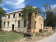
One of the buildings at the old St
Matthews Mission School
835:, born in Keiskammahoek in 1870, international cricketer
819:, born in Keiskammahoek in 1865, international cricketer
751:
and the agricultural production has declined somewhat.
1299:
Populated places in the
Amahlathi Local Municipality
608:
Keiskammahoek is situated near the headlands of the
1290:
899:, Sundayindybooks.blogspot.com. February 2013.
921:
855:
853:
851:
849:
670:. Unsourced material may be challenged and
517:. Unsourced material may be challenged and
928:
914:
846:
734:Learn how and when to remove this message
581:Learn how and when to remove this message
440:
1291:
782:Keiskammahoek houses the medium-sized
1028:Amathole District within South Africa
909:
114:
84:
54:
804:
668:adding citations to reliable sources
635:
515:adding citations to reliable sources
482:
244:15.67 km (6.05 sq mi)
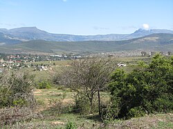
35:View of Keiskammahoek from the hill
16:Place in Eastern Cape, South Africa
13:
1023:
936:Municipalities and communities of
777:
14:
1315:
897:Interview with Marguerite Poland
640:
487:
198:
178:
113:
106:
83:
76:
53:
46:
29:
829:and longtime Minister of Labour
938:Amathole District Municipality
890:
871:
603:Amathole District Municipality
1:
839:
464:. From 1981 until the end of
599:Amahlathi Local Municipality
478:
7:
468:, the town was part of the
10:
1320:
861:"Main Place Keiskammahoek"
631:
252:670 m (2,200 ft)
1206:
1163:
1118:
1084:
1035:
1021:
960:
948:
827:African National Congress
754:Just outside the town is
429:
417:
404:
387:
379:
368:
357:
346:
338:
330:
319:
304:
293:
282:
277:
269:
261:
256:
248:
240:
235:
223:
211:
191:
171:
136:
40:
28:
21:
883:8 September 2009 at the
789:
756:St Matthew's High School
97:Show map of South Africa
67:Show map of Eastern Cape
878:Keiskammahoek Home Page
273:280/km (730/sq mi)
1029:
446:
1027:
760:Bishop of Grahamstown
458:Eastern Cape Province
444:
823:Membathisi Mdladlana
664:improve this section
511:improve this section
278:Racial makeup (2011)
270: • Density
595:King William's Town
456:) is a town in the
152: /
1030:
887:at Amahlathi.co.za
817:William Greenstock
784:S.S. Gida Hospital
626:Afromontane forest
447:
380: • Other
331: • Other
262: • Total
241: • Total
127:Show map of Africa
1286:
1285:
1268: (Mhlangeni)
805:Notable residents
795:Marguerite Poland
744:
743:
736:
718:
591:
590:
583:
565:
439:
438:
156:32.683°S 27.150°E
1311:
930:
923:
916:
907:
906:
900:
894:
888:
875:
869:
868:
857:
739:
732:
728:
725:
719:
717:
676:
644:
636:
586:
579:
575:
572:
566:
564:
523:
491:
483:
204:
202:
201:
184:
182:
181:
167:
166:
164:
163:
162:
157:
153:
150:
149:
148:
145:
128:
117:
116:
110:
98:
87:
86:
80:
68:
57:
56:
50:
33:
19:
18:
1319:
1318:
1314:
1313:
1312:
1310:
1309:
1308:
1289:
1288:
1287:
1282:
1202:
1159:
1141: (Centane)
1114:
1080:
1071:Queensberry Bay
1047: (Chintsa)
1031:
1019:
956:
950:District seat:
944:
934:
904:
903:
895:
891:
885:Wayback Machine
876:
872:
859:
858:
847:
842:
807:
792:
780:
778:Health facility
740:
729:
723:
720:
683:"Keiskammahoek"
677:
675:
661:
645:
634:
610:Keiskamma River
587:
576:
570:
567:
530:"Keiskammahoek"
524:
522:
508:
492:
481:
425:
413:
340:First languages
199:
197:
179:
177:
161:-32.683; 27.150
160:
158:
154:
151:
146:
143:
141:
139:
138:
132:
131:
130:
129:
126:
125:
124:
123:
122:
118:
101:
100:
99:
96:
95:
94:
93:
92:
88:
71:
70:
69:
66:
65:
64:
63:
62:
58:
36:
24:
17:
12:
11:
5:
1317:
1307:
1306:
1301:
1284:
1283:
1281:
1280:
1275:
1269:
1263:
1258:
1253:
1248:
1243:
1238:
1233:
1228:
1223:
1218:
1212:
1210:
1208:Raymond Mhlaba
1204:
1203:
1201:
1200:
1195:
1190:
1185:
1180:
1175:
1169:
1167:
1161:
1160:
1158:
1157:
1152:
1147:
1142:
1136:
1130:
1124:
1122:
1116:
1115:
1113:
1112:
1107:
1102:
1097:
1096: (Dutywa)
1090:
1088:
1082:
1081:
1079:
1078:
1073:
1068:
1063:
1058:
1053:
1048:
1041:
1039:
1033:
1032:
1022:
1020:
1018:
1017:
1012:
1007:
1002:
997:
992:
987:
982:
977:
972:
966:
964:
958:
957:
949:
946:
945:
933:
932:
925:
918:
910:
902:
901:
889:
870:
844:
843:
841:
838:
837:
836:
830:
820:
814:
806:
803:
791:
788:
779:
776:
763:John Armstrong
742:
741:
648:
646:
639:
633:
630:
614:Albany Thicket
589:
588:
495:
493:
486:
480:
477:
452:(also spelled
437:
436:
433:
427:
426:
423:
421:
415:
414:
411:
409:
402:
401:
391:
385:
384:
381:
377:
376:
373:
366:
365:
362:
355:
354:
351:
344:
343:
336:
335:
332:
328:
327:
324:
317:
316:
313:
302:
301:
298:
291:
290:
287:
280:
279:
275:
274:
271:
267:
266:
263:
259:
258:
254:
253:
250:
246:
245:
242:
238:
237:
233:
232:
227:
221:
220:
215:
209:
208:
195:
189:
188:
175:
169:
168:
134:
133:
120:
119:
112:
111:
105:
104:
103:
102:
90:
89:
82:
81:
75:
74:
73:
72:
60:
59:
52:
51:
45:
44:
43:
42:
41:
38:
37:
34:
26:
25:
22:
15:
9:
6:
4:
3:
2:
1316:
1305:
1302:
1300:
1297:
1296:
1294:
1279:
1276:
1274: (Ixesi)
1273:
1270:
1267:
1264:
1262:
1259:
1257:
1254:
1252:
1249:
1247:
1244:
1242:
1241:Fort Beaufort
1239:
1237:
1234:
1232:
1229:
1227:
1224:
1222:
1219:
1217:
1214:
1213:
1211:
1209:
1205:
1199:
1196:
1194:
1191:
1189:
1186:
1184:
1181:
1179:
1176:
1174:
1171:
1170:
1168:
1166:
1162:
1156:
1153:
1151:
1148:
1146:
1143:
1140:
1137:
1135: (Gcuwa)
1134:
1131:
1129:
1126:
1125:
1123:
1121:
1117:
1111:
1108:
1106:
1103:
1101:
1098:
1095:
1092:
1091:
1089:
1087:
1083:
1077:
1074:
1072:
1069:
1067:
1064:
1062:
1059:
1057:
1054:
1052:
1049:
1046:
1043:
1042:
1040:
1038:
1034:
1026:
1016:
1013:
1011:
1008:
1006:
1005:Keiskammahoek
1003:
1001:
998:
996:
993:
991:
988:
986:
983:
981:
978:
976:
973:
971:
968:
967:
965:
963:
959:
955:
954:
947:
943:
939:
931:
926:
924:
919:
917:
912:
911:
908:
898:
893:
886:
882:
879:
874:
866:
862:
856:
854:
852:
850:
845:
834:
833:Henry Taberer
831:
828:
824:
821:
818:
815:
812:
809:
808:
802:
800:
796:
787:
785:
775:
771:
767:
764:
761:
757:
752:
750:
738:
735:
727:
716:
713:
709:
706:
702:
699:
695:
692:
688:
685: –
684:
680:
679:Find sources:
673:
669:
665:
659:
658:
654:
649:This section
647:
643:
638:
637:
629:
627:
623:
619:
615:
611:
606:
604:
600:
596:
585:
582:
574:
563:
560:
556:
553:
549:
546:
542:
539:
535:
532: –
531:
527:
526:Find sources:
520:
516:
512:
506:
505:
501:
496:This section
494:
490:
485:
484:
476:
474:
471:
467:
463:
459:
455:
451:
450:Keiskammahoek
443:
434:
432:
428:
422:
420:
416:
410:
407:
403:
399:
395:
392:
390:
386:
382:
378:
374:
372:
369: •
367:
363:
361:
358: •
356:
352:
350:
347: •
345:
341:
337:
333:
329:
325:
323:
320: •
318:
314:
312:
308:
305: •
303:
299:
297:
294: •
292:
288:
286:
285:Black African
283: •
281:
276:
272:
268:
264:
260:
255:
251:
247:
243:
239:
234:
231:
228:
226:
222:
219:
216:
214:
210:
207:
196:
194:
190:
187:
176:
174:
170:
165:
137:Coordinates:
135:
121:Keiskammahoek
109:
91:Keiskammahoek
79:
61:Keiskammahoek
49:
39:
32:
27:
23:Keiskammahoek
20:
1155:Qolora Mouth
1004:
975:Braunschweig
951:
942:Eastern Cape
892:
873:
864:
811:Alice Pegler
798:
793:
781:
772:
768:
753:
745:
730:
721:
711:
704:
697:
690:
678:
662:Please help
650:
607:
592:
577:
568:
558:
551:
544:
537:
525:
509:Please help
497:
462:South Africa
454:Keiskamahoek
453:
449:
448:
225:Municipality
206:Eastern Cape
186:South Africa
1272:Middledrift
1145:Mazeppa Bay
1133:Butterworth
1015:Stutterheim
970:Border Post
953:East London
865:Census 2011
749:Stutterheim
406:Postal code
159: /
1293:Categories
1236:Calderwood
1198:Wooldridge
1128:Blythswood
1110:Willowvale
1100:Elliotdale
1066:Morgan Bay
840:References
694:newspapers
618:Grasslands
541:newspapers
257:Population
1246:Healdtown
1056:Kei Mouth
1051:Haga Haga
1037:Great Kei
995:Frankfort
980:Burnshill
962:Amahlathi
724:July 2023
651:does not
571:July 2023
498:does not
479:Geography
473:bantustan
466:apartheid
431:Area code
389:Time zone
360:Afrikaans
249:Elevation
230:Amahlathi
1251:Hogsback
1216:Adelaide
1165:Ngqushwa
1150:Nqamakwe
1010:Mnyameni
1000:Kei Road
990:Debe Nek
985:Cathcart
881:Archived
622:Savannah
408:(street)
296:Coloured
218:Amathole
213:District
193:Province
1278:Seymour
1266:Hertzog
1261:Kwezana
1256:Katberg
1231:Bedford
1226:Balfour
1183:Hamburg
1139:Kentani
1094:Idutywa
1086:Mbhashe
708:scholar
672:removed
657:sources
632:History
597:in the
555:scholar
519:removed
504:sources
371:English
173:Country
147:27°09′E
144:32°41′S
1304:Ciskei
1193:Wesley
1188:Peddie
1178:Bodiam
1120:Mnquma
1105:Hobeni
1076:Sihota
1045:Cintsa
799:Shades
710:
703:
696:
689:
681:
557:
550:
543:
536:
528:
470:Ciskei
419:PO box
342:(2011)
307:Indian
203:
183:
1221:Alice
1061:Komga
790:Other
715:JSTOR
701:books
562:JSTOR
548:books
394:UTC+2
353:94.6%
349:Xhosa
322:White
311:Asian
289:97.1%
265:4,429
1173:Bell
687:news
655:any
653:cite
624:and
534:news
502:any
500:cite
424:5670
412:5670
398:SAST
383:2.6%
375:1.1%
364:1.8%
334:1.0%
326:0.3%
315:0.2%
300:1.4%
236:Area
797:'s
666:by
513:by
435:040
1295::
940:,
863:.
848:^
628:.
620:,
616:,
475:.
460:,
929:e
922:t
915:v
867:.
737:)
731:(
726:)
722:(
712:·
705:·
698:·
691:·
674:.
660:.
584:)
578:(
573:)
569:(
559:·
552:·
545:·
538:·
521:.
507:.
400:)
396:(
309:/
Text is available under the Creative Commons Attribution-ShareAlike License. Additional terms may apply.


